Indian National Centre for Ocean Information Services (INCOIS)
- 09 Feb 2026
In News:
The Indian National Centre for Ocean Information Services (INCOIS) will launch three new ocean information services-JellyAIIP, SAMUDRA 2.0 Mobile App, and SIVAS, along with a new institutional logo during its foundation day celebrations.
About INCOIS
- Established: 1999
- Status: Autonomous body
- Ministry: Ministry of Earth Sciences (MoES)
- Headquarters: Hyderabad, Telangana
- Mandate:
- Provide ocean information and advisory services to society, industry, government agencies, and the scientific community
- Based on sustained ocean observations and focused scientific research
- International Role: Permanent member of Intergovernmental Oceanographic Commission (IOC) of UNESCO
- Key Infrastructure:
- Established the Indian Tsunami Early Warning Centre (ITEWC), which issues tsunami alerts within 10 minutes
- Serves India and 28 Indian Ocean countries
Major Existing Initiatives of INCOIS
- SARAT (Search and Rescue Aided Tool): Assists Indian Coast Guard, Navy, and Coastal Security Police in locating persons or objects lost at sea
- SynOPS Platform: A data visualisation and integration system for real-time ocean and weather data, improving coordination during extreme events
Newly Launched Ocean Information Services
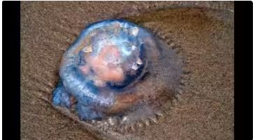
1. JellyAIIP
- Full Form: Jellyfish Aggregation Information Interactive Portal
- Type: National web-based platform
- Purpose: Reporting and visualisation of jellyfish aggregation, swarming, and stranding events along the Indian coast
- Features:
- Geospatial mapping and hotspot analysis
- Multilingual first-aid guidance for jellyfish stings
2. SAMUDRA 2.0 Mobile App
- Nature: Upgraded version of the existing SAMUDRA platform
- Function: Delivers ocean advisories and early warnings
- Target Users: Fishermen and maritime stakeholders
- Key Feature: Multilingual interface for wider accessibility
3. SIVAS
- Full Form: Swell-Surge Inundation Vulnerability Advisory System
- Type: Coastal inundation early warning service
- Function: Provides advance alerts for swell-surge flooding events
- Current Coverage: Operational for the Kerala coast
- Output: Multilingual forecast bulletins
Significance
- Enhances coastal hazard preparedness and marine safety
- Strengthens early warning systems for fishermen and coastal communities
- Supports climate resilience and disaster risk reduction along India’s coastline
INCOIS wave rider buoy washes ashore in Gopalpur (New Indian Express)
- 04 Dec 2023
Why is it in the News?
A wave rider buoy, equipped belonging to the Indian National Centre for Ocean Information Services (INCOIS), with GPS and various weather-related instruments, was found ashore at the Gopalpur Military Station in Ganjam district on Saturday.
About Indian National Centre for Ocean Information Services (INCOIS):
- INCOIS is an autonomous organization under the Ministry of Earth Sciences (MoES).
- It is a unit of the Earth System Science Organization (ESSO), New Delhi.
- It is located in Hyderabad & was established in 1999.
- The ESSO operates as an executive arm of the Ministry of Earth Sciences (MoES) for its policies and programmes.
- It is mandated to provide the best possible ocean information and advisory services to society, industry, government agencies and the scientific community through sustained ocean observations and constant improvement through systematic and focused research.
What is the Earth System Science Organisation (ESSO)?
- Earth System Science Organisation (ESSO) is a virtual organisation set up by the Ministry of Earth Sciences GOI in 2007 and it is the executive arm of MoES.
- It has three major branches of earth sciences viz.,
- Ocean Science & Technology
- Atmospheric Science & Technology
- Geosciences and Technology.
- The overall vision of the ESSO is to excel in knowledge and technology enterprise for the earth system science realm towards the socio-economic benefit of the Indian sub-continent and in the Indian Ocean region.
- The ESSO contributes to the areas of Weather (General) and Weather advisories specific to agriculture, aviation, shipping, sports, etc. Monsoon, Disasters (cyclones, earthquakes, tsunamis, sea level rise), Living and non-living resources (fishery advisory, poly-metallic nodules, gas hydrates, freshwater etc), Coastal and Marine Ecosystems and Climate Change, Underwater Technology.