Brown Trout

- 17 Sep 2025
In News:
- Kashmir is embarking on a significant initiative to revive its brown trout (Salmo trutta) population, a species first introduced to the Valley by the British in 1900.
- Once a hallmark of Kashmir’s cold-water streams and a popular game fish, the brown trout population had declined over decades due to unregulated angling, habitat degradation, and ecological disturbances.
- The Fisheries Department of Jammu & Kashmir plans to reintroduce the species into streams and lakes, aiming to combine conservation with tourism promotion.
About Brown Trout
- The brown trout is a cold-water, salmonid fish native to Europe, northern Africa, and parts of Asia. It prefers cool, well-oxygenated freshwater streams, often residing in crevices between boulders. Typically, individuals grow 15–22 inches in length and weigh 1–5 pounds.
- Brown trout are renowned as a game fish due to their aggressive and elusive nature, which makes angling challenging and rewarding.
- Globally, brown trout have been introduced widely as a game fish, but outside their native range, they are considered one of the world’s worst invasive species.
- In India, their introduction to Kashmir was facilitated by Frank J Mitchel, a British entrepreneur, and earlier attempts during Maharaja Pratap Singh’s era. The fish initially thrived in streams such as Panzagam, Lidder, Bringhi, and Ferozpora, eventually supporting recreational fishing and angling tourism.
Revival Initiative
The current revival project is supported under Pradhan Mantri Matsya Sampada Yojana (PMMSY) and J&K’s Holistic Agricultural Development Programme, enabling the import of 3 lakh pure brown trout eggs from Denmark. These were hatched at the Tchansar Hatchery in Kulgam, marking a milestone as previous efforts primarily focused on rainbow trout for food production rather than wild trout restoration.
Rearing brown trout posed unique challenges:
- They refuse artificial feed, requiring specially formulated diets of crustaceans mixed with cod liver oil.
- They feed in darkness, prompting hatchery modifications to simulate natural conditions and monitor feeding.
The October–November period, coinciding with their breeding season, was chosen for release as brown trout exhibit lower aggression and reduced cannibalism, increasing survival rates. Streams and lakes targeted for reintroduction include Veshav River and Kounsarnag Lake in Kulgam.
Ecological and Socioeconomic Significance
Reintroduction serves multiple purposes:
- Biodiversity restoration: Revives native aquatic fauna and strengthens freshwater ecosystems.
- Tourism enhancement: Brown trout are a draw for anglers, boosting local tourism and allied services.
- Heritage and culture: The initiative reconnects the Valley with a century-old ecological and recreational tradition.
Experts, however, caution that habitat preservation is crucial, emphasizing the need to control illegal riverbed mining and maintain clean, oxygen-rich streams for the trout’s survival.
Conservation Status and Global Context
According to the IUCN Red List, the brown trout is listed as Least Concern, reflecting its wide distribution and adaptability in native ranges. However, localized conservation efforts, such as this reintroduction in Kashmir, are essential to sustain ecologically and economically significant populations in specific regions.
Amrit Sarovar Mission
- 17 Sep 2025
In News:
- The Amrit Sarovar Mission, launched by Prime Minister Narendra Modi in April 2022, is a flagship initiative aimed at addressing water scarcity and promoting sustainable rural development across India.
- The mission seeks to construct or rejuvenate 75 Amrit Sarovars (ponds) in each district, as part of the celebrations of Azadi ka Amrit Mahotsav.
- As of 2025, the government has reported the creation of over 68,000 Amrit Sarovars nationwide, marking a significant milestone in water conservation and community engagement.
Objectives and Significance
The mission’s primary objectives include:
- Water conservation and management in rural areas.
- Enhancement of local livelihoods through irrigation, fisheries, duckery, cultivation of water chestnut, and water-based tourism.
- Promotion of social cohesion by establishing Amrit Sarovars as community gathering points.
- Integration of government initiatives through a “Whole of Government” approach, ensuring convergence of resources and expertise.
Each Amrit Sarovar is designed to have a minimum pondage area of one acre with a water-holding capacity of about 10,000 cubic metres. Surrounding vegetation typically includes trees such as Neem, Peepal, and Banyan, contributing to ecological sustainability and enhancing biodiversity.
Participatory and Institutional Framework
The site selection and supervision of Amrit Sarovars are conducted by Gram Sabhas, with Panchayat representatives overseeing the development. This participatory approach ensures that local communities have ownership and accountability for the maintenance and sustainable use of water resources.
The mission operates on convergence principles, utilizing funds and resources from multiple sources including:
- Mahatma Gandhi NREGS
- 15th Finance Commission Grants
- Pradhan Mantri Krishi Sinchai Yojana (PMKSY) sub-schemes, such as Watershed Development and Har Khet Ko Pani
- State government schemes
There is no separate financial allocation for the mission; rather, it leverages ongoing programs for maximum impact.
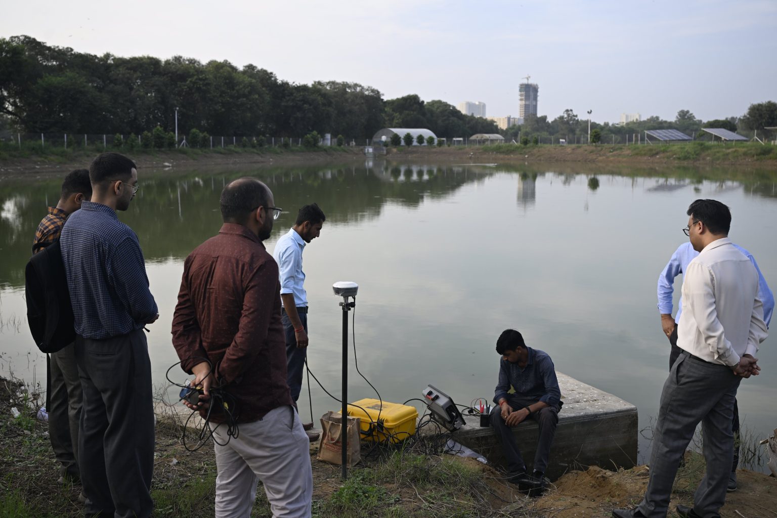
Technology and Monitoring
To ensure efficient implementation and progress tracking, the Bhaskaracharya National Institute for Space Applications and Geo-informatics (BISAG-N) has been engaged as a technical partner. The institute has developed the Amrit Sarovar Portal and Mobile App, which enables real-time monitoring, reporting, and evaluation of district-level activities.
Workshops and Capacity Building
The Ministry of Rural Development organized a national workshop in New Delhi to reinforce the mission’s technical foundations and promote community-driven sustainable practices. Officials from states and Union Territories discussed strategies to enhance technical capacity, innovation, and inter-departmental collaboration, paving the way for the next phase of the mission.
Impact and Prospects
The Amrit Sarovar Mission exemplifies integrated rural development, linking water security, ecological sustainability, and livelihood generation. By reviving traditional water bodies and creating new ponds, it contributes to groundwater recharge, climate resilience, and rural prosperity. The initiative also strengthens people’s participation in natural resource management, ensuring that water resources are used efficiently and sustainably.
As the mission progresses, it is expected to play a critical role in mitigating rural water crises, enhancing agricultural productivity, and fostering inclusive growth in India’s villages.
Erra Matti Dibbalu

- 17 Sep 2025
In News:
Andhra Pradesh has taken a major step towards global heritage recognition with the inclusion of Erra Matti Dibbalu (Red Sand Dunes) near Visakhapatnam and the Natural Heritage of Tirumala Hills in the UNESCO Tentative List of World Heritage Sites. The move reflects India’s growing commitment to protect and preserve sites of geological and ecological importance. Being placed on the Tentative List is a mandatory prerequisite for eventual nomination to the UNESCO World Heritage List, symbolizing international acknowledgment of a site’s Outstanding Universal Value (OUV).
Erra Matti Dibbalu: India’s Rare Coastal Geo-Heritage Site
- Located along the coast near Visakhapatnam, Erra Matti Dibbalu—literally “Red Sand Dunes”—is a unique National Geo-heritage Monument, spread over 1,500 acres.
- The formations consist of sand, silt, and clay, with their deep red hue arising from natural oxidation over thousands of years.
- These dunes exhibit badland topography with striking geomorphic features such as gullies, buried channels, paired terraces, beach ridges, wave-cut terraces, knick points, and waterfalls.
- The site represents the late Quaternary geologic age and provides vital evidence of climatic and sea-level fluctuations over millennia. Dendritic drainage patterns and layered sediments at the site act as a natural archive of environmental changes and coastal evolution.
- First recorded in 1886 by British geologist William King, the site is globally rare — with only two similar formations identified, one in Sri Lanka and another in Tamil Nadu (Teri Sands).
- Additionally, archaeological artefacts discovered here point to Upper Palaeolithic human activity (around 20,000 BCE), making it an important cultural and scientific site.
- Recognizing its geological and historical significance, the Geological Survey of India (GSI) declared Erra Matti Dibbalu a National Geo-heritage Monument in 2016. However, experts warn that unregulated tourism and filming activities pose a threat to its fragile ecosystem, calling for stronger conservation and monitoring mechanisms.
- According to IUCN’s Geological World Heritage (2021) classification, the site may qualify under Theme 2: Tectonic System and Theme 7: Coastal System.
Tirumala Hills: A Geological and Ecological Treasure
- The Tirumala Hills in Tirupati district are celebrated not just for spiritual significance but also for their geological, ecological, and cultural heritage.
- The hills showcase the Eparchaean Unconformity—a rare geological boundary where 2.5-billion-year-old Archean rocks meet younger Proterozoic formations of the Cuddapah Supergroup. This boundary represents a vast time gap in Earth’s geological record, offering critical insights into planetary evolution.
- The site also houses the famous Natural Arch (Silathoranam), a naturally sculpted rock formation estimated to be 1.5 billion years old. The region forms part of the Seshachalam Biosphere Reserve and Venkateswara National Park, both home to rich biodiversity including endangered red sanders (Pterocarpus santalinus), Cycas beddomei, and the elusive Jerdon’s Courser.
- With dense forests, seasonal waterfalls, and unique geological formations, Tirumala Hills qualify under multiple UNESCO criteria related to natural beauty, ecological diversity, and geological significance. As per IUCN (2021), the site aligns with Theme 1: History of Planet Earth and Evolution of Life.
AI-Based Weather Forecasting for Agriculture
- 17 Sep 2025
In News:
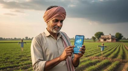
India has launched a pioneering initiative that marks a paradigm shift in agricultural planning and climate risk management. The Ministry of Agriculture and Farmers’ Welfare (MoAFW) has implemented the country’s first-of-its-kind AI-based weather forecasting program aimed at empowering farmers with timely and accurate monsoon information. This initiative has reached 3.8 crore farmers across 13 states, positioning India as a global leader in applying artificial intelligence to agriculture.
Transforming Weather Forecasting through AI
Traditionally, Indian farmers depend heavily on the monsoon for Kharif cultivation — a critical determinant of rural livelihoods. Unpredictable rainfall patterns, intensified by climate change, have often disrupted sowing and crop management decisions. To address this, MoAFW harnessed artificial intelligence (AI) models to provide advance and localized monsoon forecasts, disseminated via SMS through the m-Kisan portal.
These AI-based monsoon forecasts were available up to four weeks earlier than usual, allowing farmers to make informed choices on what, when, and how much to plant. The initiative also ensured weekly forecast updates, especially during the 20-day pause in monsoon progression this year, helping farmers adjust operations accordingly.
AI Models and Technological Backbone
The forecasts were generated using a blend of two open-access AI models:
- Google’s Neural General Circulation Model (Neural GCM), and
- ECMWF’s Artificial Intelligence Forecasting System (AIFS) developed by the European Centre for Medium-Range Weather Forecasts.
Rigorous evaluation showed that these models outperformed traditional meteorological forecasts, particularly in predicting the onset and variability of monsoon rainfall at local levels. The initiative represents the first targeted dissemination of AI-based weather forecasts to farmers anywhere in the world.
m-Kisan Portal
The m-Kisan Portal serves as the digital backbone for this outreach. It enables government agencies and research institutions to deliver customized, location-specific, and language-tailored SMS advisories to farmers. Beyond weather forecasts, it also provides guidance on pest management, crop practices, and government schemes, thus strengthening the digital extension ecosystem in Indian agriculture.
Bairabi–Sairang Project
- 17 Sep 2025
In News:
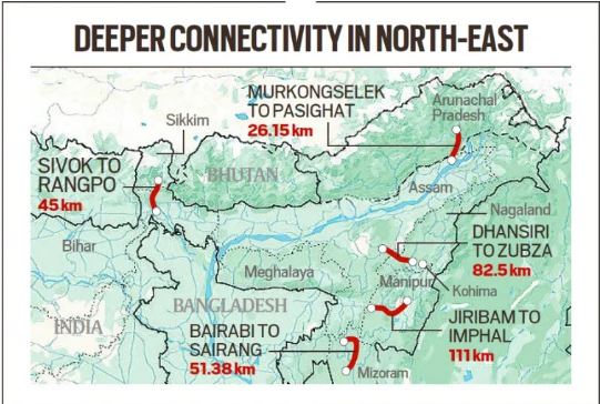
The inauguration of Mizoram’s first-ever railway line — the Bairabi–Sairang Broad-Gauge Project — marks a historic milestone in the state’s connectivity and India’s Act East Policy. Prime Minister Narendra Modi inaugurated the 51.38-km line, constructed at a cost of ?8,070 crore, connecting Mizoram’s capital Aizawl to the national railway network for the first time.
A 15-Year Vision Realised
- Sanctioned in 2008–09 and launched for construction in 2015, the project exemplifies one of the most complex undertakings of the Indian Railways due to Mizoram’s mountainous terrain and fragile geology.
- Nearly 54% of the alignment passes through tunnels and bridges, making it a remarkable feat of engineering. The route comprises 45–48 tunnels, 142 bridges (including 55 major and 87 minor ones), and 10 road overpasses/underpasses.
- Among its iconic structures is Bridge No. 144 (or 196) near Sairang, which stands over 104–114 metres tall, surpassing the height of Delhi’s Qutub Minar and making it India’s tallest pier railway bridge.
- The project also introduced four new stations — Hortoki, Kawnpui, Mualkhang, and Sairang — linking remote communities and enhancing regional mobility.
Connecting Aizawl to the National Network
The line stretches from Bairabi on the Assam–Mizoram border to Sairang, located just 20 km from Aizawl, thereby integrating Mizoram’s capital into India’s railway map. With this, Aizawl becomes the fourth northeastern capital (after Guwahati, Agartala, and Itanagar) to gain direct rail connectivity, strengthening socio-economic linkages between the Northeast and the rest of India.
Boosting Regional Connectivity and Economic Growth
The newly inaugurated line will facilitate safe, efficient, and cost-effective transportation, reducing travel time and improving the movement of goods such as food grains, fertilizers, and essential commodities. It is also expected to stimulate tourism, horticulture, and local industries, generating employment and boosting livelihoods.
The Prime Minister also flagged off three new long-distance train services —
- Sairang–Delhi Rajdhani Express,
- Sairang–Guwahati Express, and
- Sairang–Kolkata Express —further enhancing the state’s integration with major urban centres.
Engineering Challenges and Innovations
Constructing railways across Mizoram’s steep ridges and fragile hills required advanced tunnelling techniques and innovative stabilization methods. Engineers had to solidify loose sand into rock formations before tunnelling. The passenger trains can now run at speeds up to 100 km/h, reflecting the project’s high safety and design standards.
Complementary Infrastructure Initiatives
Alongside the rail inauguration, infrastructure projects worth ?9,000 crore were launched under schemes like PM-DevINE and NESIDS, including:
- Aizawl Bypass Road (45 km),
- Thenzawl–Sialsuk Road, and
- Khankawn–Rongura Road, aimed at improving connectivity for farmers, traders, and industries.
Additionally, the Chhimtuipui Bridge under the Kaladan Multimodal Transit Project, an LPG bottling plant at Mualkhang, sports complexes, and Eklavya residential schools were announced to promote economic growth and human development.
Strategic and Policy Significance
The Bairabi–Sairang line is a critical component of India’s Act East Policy, designed to enhance connectivity and integration of the Northeast with Southeast Asia. It embodies India’s commitment to balanced regional development, national security, and border area empowerment.
By overcoming formidable terrain and logistical hurdles, the project stands as a testament to India’s infrastructural capabilities and its vision for an inclusive, connected, and self-reliant Northeast.