Biomass-based Improved Cookstoves (ICS)
- 19 Apr 2026
In News:
In the wake of recent LPG supply disruptions and rising fuel costs, the conversation around India's energy transition has pivoted toward Modern Biomass-based Improved Cookstoves (ICS). While the Pradhan Mantri Ujjwala Yojana (PMUY) significantly expanded LPG access, many rural households have begun "stacking" fuels or shifting back to traditional firewood due to affordability issues. In this context, ICS emerges not as a step backward, but as a sophisticated, cost-effective bridge to cleaner energy.
The Technology: Redefining Biomass Combustion
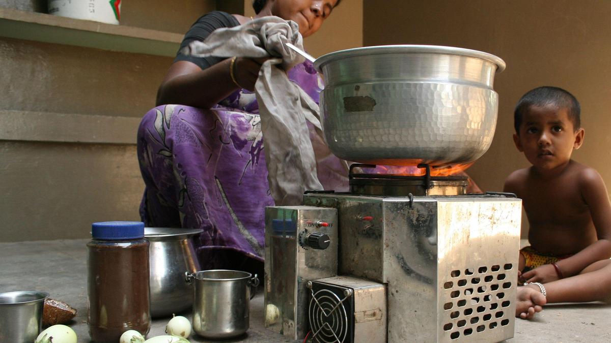
Improved Cookstoves are advanced thermal devices engineered to maximize combustion efficiency while minimizing the release of harmful pollutants. Unlike the traditional mud chulha, which is plagued by poor airflow and massive heat loss, ICS integrates modern thermodynamic principles.
- Efficiency Gains: Traditional stoves operate at a dismal efficiency of roughly 10%. In contrast, ICS achieves an efficiency of 38–45%.
- Secondary Aeration: A key technological feature in ICS is the introduction of secondary air. This process captures soot and volatile gases—which would otherwise escape as smoke—and re-combusts them. This "double burn" significantly improves indoor air quality.
The Economic and Environmental Value Proposition
For a rural household, the transition to ICS offers a compelling alternative to both traditional wood-firing and expensive LPG:
- Cost Efficiency: With firewood priced at approximately ?10/kg compared to LPG costs often exceeding ?100/kg, ICS can offer savings of over 60% for economically vulnerable families.
- Resource Conservation: Due to superior thermal efficiency, ICS can reduce the volume of firewood required by 50–66%, directly reducing the drudgery of fuel collection for women and lessening the pressure on local forests.
- Fuel Versatility: ICS models are increasingly designed to be "fuel-agnostic," capable of burning processed biomass such as pellets and briquettes, as well as raw materials like crop residues and dung cakes.
A Sustainable Financing Model: Carbon Credits
One of the most innovative aspects of modern ICS deployment is its link to the global carbon market. Because these stoves demonstrably reduce CO2 and black carbon emissions, they generate carbon credits. These credits can be traded to:
- Subsidize Upfront Costs: Making the stoves affordable for low-income households.
- Fund CSR Initiatives: Encouraging corporate involvement in rural energy health.
- Support Microfinance: Creating a circular economy where emission reductions pay for the hardware.
Implementation Challenges and the Way Forward
Despite their benefits, the large-scale adoption of ICS faces significant hurdles:
- The "Last-Mile" Logistical Gap: Unlike LPG, which relies on a centralized bottling infrastructure, ICS success depends on decentralized, local distribution networks and robust after-sales support to ensure stoves remain functional.
- Emission Trade-offs: While ICS is significantly cleaner than a traditional chulha, its emissions are generally higher than those of LPG or electric cooking. It is a "transitional" technology rather than an ultimate "zero-emission" solution.
- Awareness and Behavioral Change: Deep-seated cultural cooking habits often act as a barrier to adopting new stove designs, requiring sustained community engagement.
River Basin Management Scheme
- 19 Apr 2026
In News:
Water security is a cornerstone of national stability, supporting agriculture, industry, and ecological health. In India, the complexity of transboundary rivers and diverse climatic zones necessitates a shift from fragmented water use to Integrated Water Resources Management (IWRM). The River Basin Management (RBM) Scheme, a central sector initiative under the Ministry of Jal Shakti, serves as the institutional bedrock for this transition, focusing on the sustainable development of both surface and groundwater.
Overview and Institutional Framework
The RBM Scheme is implemented by the Department of Water Resources, River Development, and Ganga Rejuvenation. It functions through three specialized nodal agencies:
- Central Water Commission (CWC): Focuses on surveys, investigations, and the preparation of Detailed Project Reports (DPRs) for irrigation and hydropower, particularly in the Indus, Brahmaputra, and Teesta basins.
- Brahmaputra Board: Manages flood control, bank erosion, and drainage improvement in the North Eastern Region (NER), including the Brahmaputra and Barak valleys.
- National Water Development Agency (NWDA): Leads the Interlinking of Rivers (ILR) program, conducting feasibility studies for inter-basin water transfers.
Strategic Scope and Financial Outlay
The scheme prioritizes strategically sensitive and water-rich but underdeveloped regions, including the Indus Basin (J&K and Ladakh) and the North Eastern Region.
- 16th Finance Commission Period: The Union Government has approved the continuation of the scheme from 2026–27 to 2030–31.
- Financial Commitment: A fully funded outlay of ?2,183 crore has been allocated, a significant increase from the ?1,276 crore allocated in the previous cycle (2021–26).
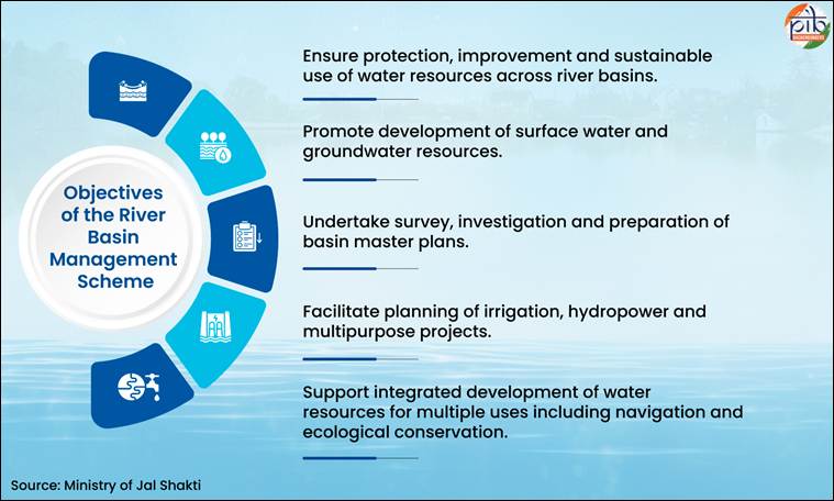
Core Objectives and Action Areas
The RBM framework is designed to move beyond traditional engineering to a holistic "ecosystem approach":
- Basin Planning: Developing and updating Master Plans that act as long-term roadmaps for resource conservation and utilization.
- Modern Survey Techniques: Leveraging advanced technologies such as GIS, Remote Sensing, LiDAR (Light Detection and Ranging), and Drone-based surveys to enhance planning accuracy in difficult terrains.
- Flood and Erosion Management: Implementing critical structural interventions, such as bank revetment and spurs, to protect vulnerable areas like Majuli Island in Assam.
- Community Interventions: Strengthening local resilience through Springshed management and the integration of indigenous water management practices with modern scientific methods.
Measurable Outcomes and Progress (2021–2026)
The scheme has achieved several milestones that bolster India's hydro-diplomacy and internal water security:
- Infrastructure Readiness: Completion of DPRs in remote Himalayan regions, creating a pipeline for future hydropower and irrigation investments.
- Interlinking Progress: The NWDA has identified 30 river links; feasibility reports for 26 and DPRs for 15 (including the Kosi–Mechi link) have been finalized.
- Erosion Control: Successful post-construction bank revetment works (e.g., at Sumoimari, Majuli) have mitigated the devastating impact of the Brahmaputra’s annual floods.
- Capacity Building: Providing technical support to "Special Category" states (Sikkim, Mizoram, Manipur, etc.) that lack the independent financial capacity for large-scale water planning.
Borrowers’ Platform

- 19 Apr 2026
In News:
At the 2026 IMF-World Bank Spring Meetings, developing nations reached a historic milestone by launching the first-ever Borrowers’ Platform. This initiative aims to rebalance a global financial architecture that has traditionally been dominated by creditor interests, such as the Paris Club. By creating a unified front, the platform seeks to address the mounting sovereign debt crisis, which saw the external debt of developing countries reach a staggering $11.7 trillion by 2024.
Objectives and Institutional Framework
The Borrowers’ Platform is designed as a technical and cooperative mechanism rather than a forum for collective bargaining or debt restructuring.
- Peer Learning and Knowledge Exchange: It facilitates a space for finance ministers and central bank governors to share practical experiences in debt management and navigate complex financial instruments like debt swaps.
- Technical Cooperation: Supported by the United Nations Conference on Trade and Development (UNCTAD) as its Secretariat, the platform leverages technical expertise to strengthen the debt-tracking systems of member states.
- Collective Voice: For the first time, borrowing nations have a formal institutional framework to articulate shared positions in global debt discussions, moving away from the "passive standard-setting" imposed by lenders.
Governance and Membership
The platform represents a diverse coalition of the Global South, bridging major economies with vulnerable states.
- Leadership: The platform is currently led by a working group chaired by Egypt, with Pakistan serving as the Vice-Chair.
- Membership: It comprises 30 member nations, including major emerging economies like India and South Africa, alongside countries such as Colombia, Honduras, Nepal, and Zambia.
- Institutional Backing: The initiative was first proposed by the UN Secretary-General’s Expert Group on Debt in 2025 and later codified in the Sevilla Commitment 2025 and the UNCTAD16 Geneva Consensus.
Significance for the Global South
The platform addresses several structural gaps in the international financial system:
- Rebalancing Power Dynamics: Historically, creditors coordinated through the Paris Club or the London Club, leaving borrowers to negotiate in isolation. This platform provides a necessary counterweight.
- Market Signaling: By improving transparency and data accuracy, the platform aims to reduce "perceived risk" among global investors, potentially lowering borrowing costs and interest rates—which are often twice as high for developing nations compared to advanced economies.
- Fiscal Space for Development: With 54 countries currently spending more on debt servicing than on healthcare or education, the platform’s emphasis on sustainable financing is critical for achieving the Sustainable Development Goals (SDGs).
Delhi High Court’s Landmark Ruling on IVF
- 19 Apr 2026
In News:
In a significant judicial intervention that bridges the gap between medical jurisprudence and constitutional rights, the Delhi High Court recently permitted a woman to proceed with In-vitro Fertilization (IVF) using the genetic material of her husband, an Indian Army soldier currently in a vegetative state. The ruling underscores the evolution of Article 21 of the Indian Constitution, expanding the interpretation of reproductive autonomy and the "Right to Life" in extraordinary circumstances.
The Judicial Context: Article 21 and Reproductive Rights
The core of the petitioner’s plea rested on the fundamental right to motherhood and dignity. The court recognized that the right to reproduce is an essential facet of a person's liberty. By invoking Article 21 (Right to Life and Personal Liberty), the court emphasized that reproductive choices are central to an individual’s dignity and autonomy.
In this unique case, the soldier had expressed a prior intent to have a child before entering a permanent vegetative state (a disorder of consciousness). The court held that his current inability to provide "active" consent does not negate his prior intent or the wife's right to pursue motherhood within the marital bond.
Legal Interpretation of the ART Act, 2021
- The primary legal challenge involved the Assisted Reproductive Technology (Regulation) Act, 2021, which typically mandates the written consent of both parties for any ART procedure.
- However, the Delhi High Court adopted a purposive interpretation of the law. It ruled that in this exceptional scenario, the wife's consent could be legally treated as valid consent on behalf of her husband. This ruling prevents a "legal vacuum" where a spouse’s medical tragedy would otherwise permanently extinguish the other spouse’s reproductive rights.
- Despite a medical board’s observation that the chances of retrieving viable sperm were "meagre," the court prioritized the woman’s right to try, rather than the statistical probability of success.
Understanding Assisted Reproductive Technology (ART) and IVF
In-vitro Fertilization (IVF) is a complex series of procedures used to help with fertility or prevent genetic problems and assist with the conception of a child.
- The Process: Mature eggs are collected (retrieved) from ovaries and fertilized by sperm in a laboratory. The fertilized egg (embryo) is then transferred to a uterus. One full cycle of IVF takes about three weeks.
- Regulatory Framework: In India, these procedures are governed by the ART (Regulation) Act, 2021. This Act provides for the regulation and supervision of ART clinics and banks, preventing misuse and ensuring safe and ethical practices.
- Government Support: Recognizing infertility as a significant reproductive health issue, the Central Government Health Scheme (CGHS) provides financial assistance by reimbursing IVF cycles for eligible beneficiaries, thereby increasing accessibility to these expensive technologies.
Delimitation and Women’s Reservation in Legislatures
- 19 Apr 2026
In News:
The Union government has introduced a historic legislative package aimed at reshaping India's parliamentary landscape. Through the Constitution (131st Amendment) Bill, 2026, the Delimitation Bill, 2026, and the Union Territories Laws (Amendment) Bill, 2026, the government seeks to synchronize three critical democratic objectives: the expansion of the Lok Sabha, the conduct of a fresh delimitation exercise based on recent data, and the immediate operationalization of the Nari Shakti Vandan Adhiniyam (33% women’s reservation).
Key Legislative Provisions
1. The Constitution (131st Amendment) Bill, 2026
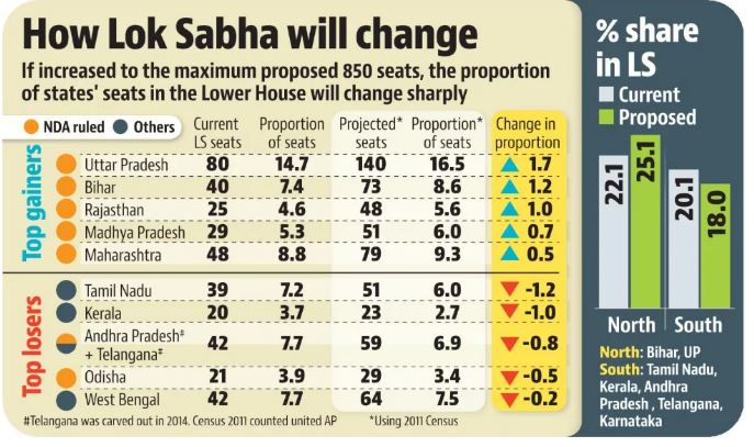
- Expansion of Lok Sabha: The Bill proposes amending Article 81 to increase the maximum strength of the Lok Sabha from 550 to 850 members. This includes 815 representatives from States and 35 from Union Territories.
- Decoupling from the Post-2026 Census: Current provisions under Article 81 and 82 freeze seat allocation based on the 1971 Census until the first census after 2026 is published. The new amendment removes this "delimitation freeze," allowing the government to use the 2011 Census (or any census Parliament decides by law) to redraw boundaries immediately.
- Legislative Hurdles: As a constitutional amendment affecting federal representation, this Bill requires a special majority in both Houses of Parliament and ratification by at least 50% of State Legislatures.
2. The Delimitation Bill, 2026
- The Commission: This Bill replaces the Delimitation Act of 2002 and establishes a new Delimitation Commission. The body will be chaired by a Supreme Court judge and include the Chief Election Commissioner and State Election Commissioners.
- Mandate: The Commission is tasked with redrawing territorial constituencies to ensure they are geographically compact and reflect population shifts, upholding the principle of “one person, one vote, one value.”
- Finality of Orders: Once the Commission’s orders are notified, they carry the force of law and cannot be challenged in any court.
3. The Union Territories Laws (Amendment) Bill, 2026
- This enabling legislation extends the structural changes and women’s reservation to UTs with legislatures, specifically Delhi, Puducherry, and Jammu & Kashmir.
Operationalizing Women’s Reservation
The impending delimitation acts as the "trigger" for the 106th Constitutional Amendment Act, 2023.
- Implementation Timeline: By fast-tracking delimitation, the government aims to implement the 33% quota for women in the 2029 General Elections.
- Quota Dynamics: The reservation includes a sub-quota for SC/ST women but currently lacks a separate provision for OBC women. These seats will be rotated after every delimitation cycle and are subject to a 15-year "sunset clause," unless extended by Parliament.
The Core Conflict: Representation vs. Federalism
While the government emphasizes democratic parity, the move has ignited a debate over India’s federal equilibrium:
Arguments in Favor (Democratic Equity):
- Parity of Representation: Currently, an MP from a high-population state like Uttar Pradesh represents significantly more voters than an MP from a southern state, diluting the democratic weight of citizens in the north.
- Ease of Transition: Expanding the House to 850 seats ensures that while northern states gain more, no state will see a reduction in its absolute number of seats. All states are projected to see a nearly 50% increase in their total seat count.
Arguments Against (Regional Imbalance):
- The "Penalty" for Success: Southern states (Kerala, Tamil Nadu, etc.) argue that they are being punished for their success in population control and socio-economic development. Their relative political weight in the Lok Sabha is set to shrink.
- Financial Disparity: Critics argue that southern states contribute a higher share to the national GDP and tax pool. Reduced political say leads to a "taxation without representation" sentiment.
- Presidential Election Impact: Changing the number of MPs and MLAs will alter the Electoral College, potentially giving northern states a disproportionate influence in electing the President of India.
The Judicial Perspective
Historically, delimitation orders have been immune from judicial interference to prevent election delays. However, in the Kishorchandra Chhanganlal Rathod Case (2024), the Supreme Court clarified that such orders can be reviewed if they are found to be "manifestly arbitrary" or violate core constitutional values.