Keezhadi Excavations
- 24 May 2025
In News:
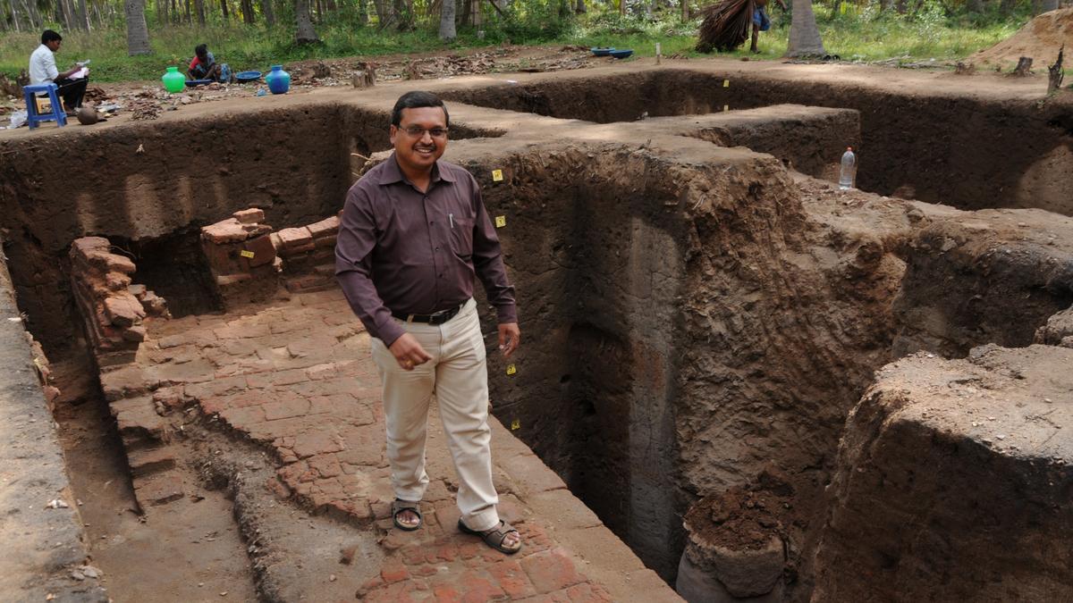
The Keezhadi archaeological site, located near Madurai along the Vaigai River in Tamil Nadu’s Sivaganga district, is a major site of cultural and historical significance. It offers compelling evidence of an urban, literate, and industrialized Tamil civilization dating back to the Sangam Age.
Background and Discovery
- Discovered: Surveys in 2013–14; Excavations began in 2015.
- Excavating Agencies: Initially conducted by the Archaeological Survey of India (ASI) and later by the Tamil Nadu State Archaeology Department.
- Excavated Area: Only 1 out of 100 acres has been explored; over 4,000 artefacts recovered.
Significant Findings
- Carbon Dating (AMS) of charcoal: Indicates urban habitation existed by 200 BCE.
- Key Discoveries: Brick structures, ring wells, pottery with Tamil-Brahmi inscriptions, beads, graffiti, water storage facilities, and a large decorative pot unique to the region.
- Artefacts suggest links with North India and Western trade networks.
Cultural and Historical Significance
- Suggests early urbanization in South India, independent of northern influence.
- Supports theories of a pre-Sangam urban Tamil culture.
- Establishes Keezhadi as a centre of literacy, trade, and craftsmanship.
- Mention of nearby settlements like Manalur and Konthagai in Tamil classics such as Tiruvilayadal Puranam strengthens the site's literary links.
Sangam Period Context
- Spanned approximately 3rd century BCE to 3rd century CE.
- Tamil academies or ‘Sangams’ under the Pandya dynasty produced extensive literature.
- Notable texts: Tolkappiyam, Ettuthogai, Pattupattu, Padinenkilkanakku, and epics like Silappadikaram, Manimekalai, and CivakaCintamani.
- Literature depicts advanced socio-political systems, agriculture, trade, and maritime activities.
Current Issues and ASI Involvement
- The excavation report prepared by archaeologist Amarnath Ramakrishna (submitted in January 2023) has been returned by ASI for revision to ensure:
- Accurate period classification.
- Better stratigraphic and cartographic details.
- Consistency in scientific dating and layer mapping.
- ASI has flagged the need for clearer mapping, missing illustrations, and precise scientific justification for dating claims, especially for Period I (8th to 5th century BCE).
Controversy and Criticism
- Concerns have been raised over delays in publishing excavation reports.
- Critics highlight a perceived bias in the handling of southern archaeological sites, pointing to similar delays with the Adichanallur site report.
- Experts stress the importance of transparent and timely reporting to enhance historical understanding.
National Centre for Polar and Ocean Research (NCPOR)
- 24 May 2025
In News:
To mark its 25th anniversary, the Union Minister of Earth Sciences inaugurated two landmark facilities—Polar Bhavan and Sagar Bhavan—at the NCPOR campus in Vasco da Gama, Goa.
About NCPOR
- Established: 25 May 1998 (originally as the National Centre for Antarctic and Ocean Research – NCAOR).
- Status: Autonomous R&D institute under the Ministry of Earth Sciences (MoES).
- Headquarters: Vasco da Gama, Goa.
- Governing Body: Includes 13 members; the Secretary of MoES serves as the ex-officio Chairman.
Mandate and Key Functions
- Polar Research Leadership:
- Manages India's scientific stations:
- Antarctica: Maitri and Bharati
- Arctic: Himadri
- Himalayas: Himansh
- Coordinates India’s Antarctic, Arctic, Southern Ocean, and Himalayan expeditions.
- Manages India's scientific stations:
- Oceanic Research:
- Implements projects under the Deep Ocean Mission.
- Conducts Exclusive Economic Zone (EEZ) mapping and continental shelf surveys.
- Explores deep-sea minerals, gas hydrates, and metal sulphides.
- Policy Implementation:
- Supports India’s Arctic Policy (2022) and Indian Antarctic Act (2022):
- Antarctic Act: Provides legal framework for governance and environmental protection via CAG-EP (Committee on Antarctic Governance and Environmental Protection).
- Arctic Policy: Based on six pillars—science, environment, development, connectivity, governance, and capacity building.
- Supports India’s Arctic Policy (2022) and Indian Antarctic Act (2022):
- Scientific Logistics and Collaboration:
- Operates research vessels (e.g., ORV Sagar Kanya).
- Engages in international polar networks and climate monitoring programs.
- Maintains India’s Antarctic Data Centre and conducts climate modelling.
New Facilities at NCPOR
Polar Bhavan:
- Area: 11,378 sq. m | Cost: ?55 crore
- Features:
- Advanced polar and ocean research laboratories
- Science on Sphere (SOS) 3D visualization platform
- Accommodation for 55 scientists
- Conference halls, library
- Home to India’s first Polar and Ocean Museum
Sagar Bhavan:
- Area: 1,772 sq. m | Cost: ?13 crore
- Features:
- Two -30°C ice core laboratories
- +4°C storage units for biological and sediment samples
- Class 1000 clean room for trace metal and isotope studies
Significance for India
- Strengthens India’s strategic presence in polar regions.
- Enhances research capacity in ocean and climate sciences.
- Enables India to fulfill international obligations under polar treaties.
- Promotes science diplomacy and public outreach through the upcoming museum.
Guttala Inscription
- 24 May 2025
In News:
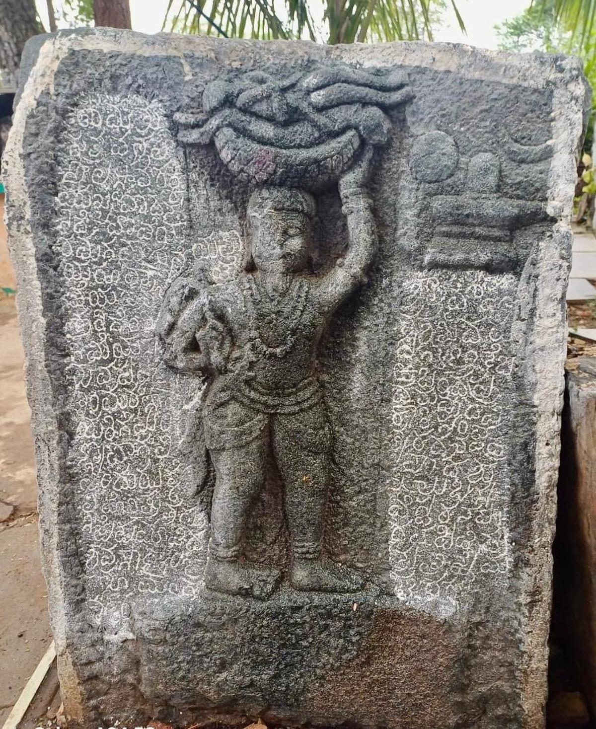
A rare 16th-century sculptural inscription discovered near the Chandrashekara temple in Guttala village, Haveri district, Karnataka, marks the earliest known epigraphic evidence in India of a large-scale humanitarian disaster caused by a natural calamity—a drought (bara) that claimed 6,307 lives in 1539 CE (Saka 1461, August 18).
Key Features of the Inscription:
- Language and Script: Kannada.
- Medium: Stone slab.
- Depiction: A sculpture showing MarulaihOdeya, the son of NanidevaOdeya, carrying a basket containing dead bodies—representing his act of burying the deceased to earn religious merit for the regional ruler, TimmarasaSvami.
- Religious Context: The burial was conducted after paying homage to Basaveshwara, reflecting the spiritual and ritualistic practices of the time.
- Territorial Reference: Mentions the term "seeme", indicating the existence of local administrative divisions.
Significance:
- First explicit historical record in India of deaths caused by a natural disaster, making it an important source for disaster history and epigraphic heritage.
- Offers textual and visual representation of community response to drought.
- Provides insights into local governance, religious customs, and socio-economic conditions of 16th-century Karnataka.
- Adds depth to the study of historical climate events, with potential to track past climatic patterns and their impact on populations.
Broader Context:
- Inscriptions in India, typically engraved on stone or metal, serve as valuable primary sources for understanding royal decrees, battles, donations, and societal events.
- Other notable Karnataka inscriptions include:
- Maski Edict (3rd Century BCE) – First mention of Emperor Ashoka as "Devanampriya".
- Halmidi Inscription (c. 450 CE) – Oldest Kannada inscription referencing Kadamba king Kakusthavarma.
- Aihole Inscription (634 CE) – Chronicles the military achievements of Pulakeshin II.
Recent Epigraphic Developments:
- The Epigraphy Branch of the Archaeological Survey of India (ASI) discovered and documented over 1,000 inscriptions across India during 2024–25, including more than 100 new finds this year alone.
- These discoveries reinforce the role of epigraphy in reconstructing Indian history, especially in areas lacking detailed literary sources.
Weather Balloons and Global Forecasting Concerns
- 24 May 2025
Background:
Weather balloons, crucial for upper atmospheric observations, are facing reduced deployment in the United States due to recent budget cuts. The National Oceanic and Atmospheric Administration (NOAA) has significantly scaled back balloon launches since March 2025 following a 25% budget reduction. This has raised global concerns among meteorologists over the potential decline in forecast accuracy.
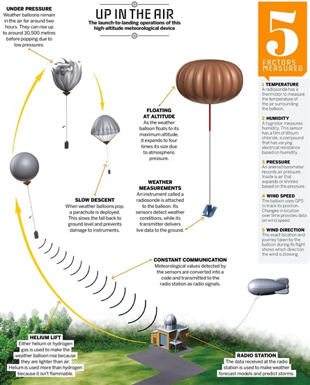
What are Weather Balloons?
- Inventor: Léon Teisserenc de Bort (France), first launched them in 1896; discovered the tropopause and stratosphere.
- Composition: Latex balloons filled with helium or hydrogen.
- Altitude: Can ascend up to 1,15,000 feet (35 km) in approximately 2 hours.
- Instrument Carried: Radiosonde – a small device suspended ~66 feet below the balloon that transmits real-time atmospheric data (temperature, pressure, humidity, wind) via radio signals.
- Technology: Modern radiosondes are lightweight, GPS-enabled, and energy-efficient.
Historical Context:
- Initial upper-air measurements in the 18th century used kites with meteorographs.
- Weather balloons replaced kites due to higher altitude capability and improved data reliability.
- The introduction of radiosondes in the 1930s revolutionized weather forecasting by enabling real-time data transmission.
Importance of Upper Air Observations
- Upper atmosphere (>5,000 feet) plays a vital role in generating surface-level weather conditions like rain, storms, and drought.
- Weather balloons help bridge the data gap between surface stations and satellites by offering vertical atmospheric profiles.
- Twice-daily launches at 0000 UTC and 1200 UTC (~5:30 AM and 5:30 PM IST) are globally coordinated at over 900 stations, including 56 in India.
India’s Scenario
- The India Meteorological Department (IMD) conducts routine balloon launches for weather forecasting.
- The National Balloon Facility (NBF) in Hyderabad, jointly managed by ISRO and TIFR, supports high-altitude atmospheric research.
Impact of Reduced Launches
- NOAA’s scaling down has sparked fears of reduced forecast accuracy globally.
- A similar move by Russia in 2015 led to a measurable decline in forecast quality across Europe, highlighting the critical role radiosondes play.
- NOAA plans to replace some balloon data with AI-powered alternatives developed by private firms to reduce costs.
Why Weather Balloons Still Matter in the Satellite Era
- Satellites provide large-scale imagery but lack the granularity of vertical atmospheric data.
- Weather balloons offer crucial insights into lower- and mid-atmospheric layers where storms and climate dynamics form.
- Radiosonde data is essential for calibrating satellite measurements, ensuring reliability in climate modeling and forecasting systems.
Sagar Mein Samman (SMS) Initiative
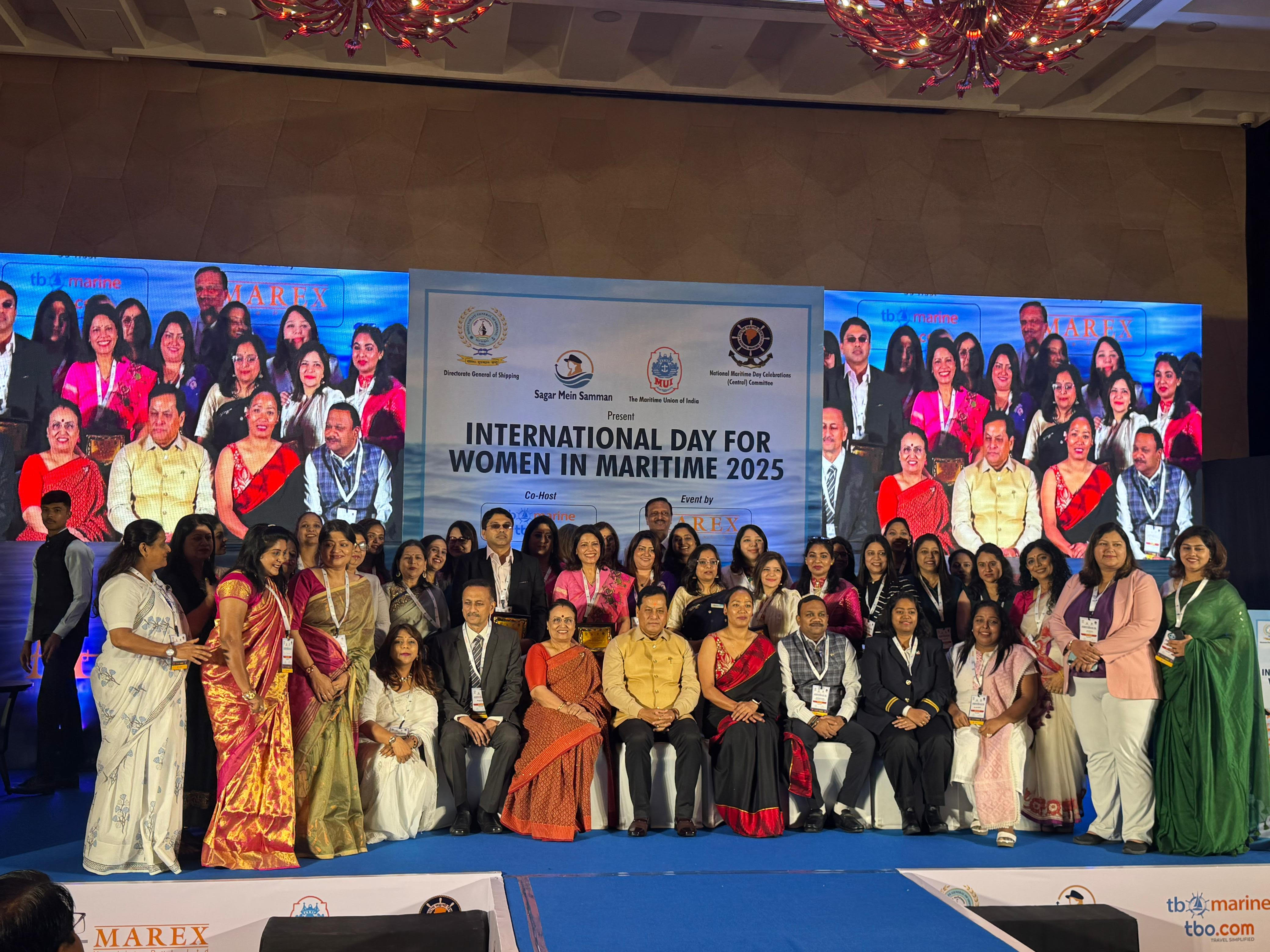
- 24 May 2025
In News:
The Government of India launched the Sagar Mein Samman (SMS) initiative on International Day for Women in Maritime (18 May), observed by the International Maritime Organization (IMO). The 2025 theme is “An Ocean of Opportunities for Women.”
About the Initiative:
- Objective: To build a gender-equitable maritime workforce by promoting inclusivity, safety, skill development, leadership, and equal opportunities for women across seafaring and shore-based maritime operations.
- Alignment:
- IMO’s gender inclusion mandate.
- UN SDG-5 (Gender Equality).
- India’s Diversity, Equity, and Inclusion (DEI) framework.
- Maritime India Vision 2030 and Maritime Amrit Kaal Vision 2047.
Key Features:
- Structured Policy Roadmap covering:
- Planning & strategy.
- Training & development.
- Research & innovation.
- Governance & compliance.
- Outreach & communications.
- Financial Support: ~2,989 women received assistance since 2014.
- Incentives for Industry: Shipping companies are incentivized to hire women; scholarships support training.
Achievements:
- 649% growth in women seafarers:From 341 in 2014 to 2,557 in 2024.
- Rise in financial aid beneficiaries:From 45 in 2014-15 to 732 in 2024-25.
- Female representation target:12% in technical maritime roles by 2030.
- Increasing employment of Indian women on Indian and foreign-flagged ships.
Recognition and Outreach:
- Women Leaders Honoured: Ten outstanding women were felicitated for their contributions to maritime.
- Focus on awareness campaigns, onshore job facilitation, and leadership opportunities.
Significance:
- Aims to dismantle gender-based barriers and promote inclusive economic growth.
- Reinforces India’s commitment to gender equity as a strategic enabler of maritime sustainability and national development.
- Aligns with global maritime norms and India’s broader commitment to SDGs.
Other Key Maritime Initiatives:
- SAGAR (Security and Growth for All in the Region): Maritime security and regional cooperation.
- Maritime India Vision 2030: Long-term strategy for port-led development and gender inclusion.