CJI Calls for National Judicial Policy
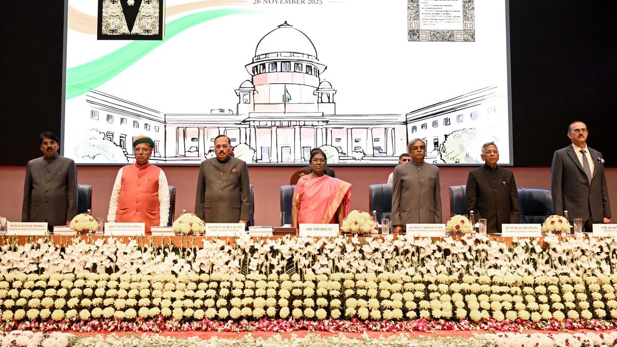
- 28 Nov 2025
In News:
The Chief Justice of India Surya Kant has advocated the formulation of a National Judicial Policy to address growing concerns over divergent judicial interpretations across High Courts and different Benches of the Supreme Court of India. The proposal is aimed at ensuring greater consistency, predictability, and coherence in judicial outcomes across the country.
What is a National Judicial Policy?
A National Judicial Policy would function as a common guiding framework for courts at all levels, laying down uniform standards of interpretation, procedure, and case management. It seeks to ensure that courts across India “speak in one rhythm” on major constitutional and legal questions, without compromising their adjudicatory independence.
Why is such a policy needed?
India’s judicial system faces frequent conflicting rulings by different High Courts on similar legal issues, creating uncertainty for citizens, governments, and institutions. Even within the Supreme Court, multiple Benches sometimes issue inconsistent orders, affecting policy implementation. With nearly 5.4 crore pending cases, the absence of standardised timelines and procedures aggravates delays. Additionally, uneven infrastructure, language barriers, high litigation costs, and geographical distance restrict access to justice, particularly for marginalised groups.
Existing and Supporting Reforms
The judiciary has already initiated several measures aligned with the spirit of a national policy. These include promotion of mediation and alternative dispute resolution, expansion of digital justice tools such as e-filing and virtual hearings, strengthening of arbitration mechanisms, and efforts toward modernising court infrastructure. International judicial cooperation and training exchanges are also being used to adopt global best practices.
Key Challenges
Implementing a national framework faces structural hurdles. India’s federal diversity, reflected in varying state laws and languages, complicates uniformity. There are also concerns that such a policy could dilute judicial independence, especially the constitutional autonomy of High Courts under Articles 225 and 226. Persistent infrastructure gaps, large judicial vacancies, resistance to procedural change, and the digital divide further constrain uniform implementation.
Way Forward
A workable National Judicial Policy must be jointly drafted by the Supreme Court, High Courts, and the Law Ministry, ensuring a balance between uniform standards and constitutional autonomy. Harmonising court procedures, strengthening the lower judiciary, expanding inclusive digital access, scaling up pre-litigation mediation, and improving coordination through regular judicial conferences are essential steps.
India’s Updated Seismic Zonation Map (2025)
- 28 Nov 2025
In News:
India has released an updated Seismic Zonation Map (2025) under the revised Earthquake Design Code (IS 1893), marking a major shift in the country’s approach to earthquake risk assessment and structural safety. The revision replaces the 2016 map and aligns India’s standards with contemporary scientific understanding and international best practices.
Why Was the Update Needed?
- Underestimation of Himalayan Risk: Earlier maps classified the Himalaya largely under Zones IV and V, despite the region being among the most tectonically active belts globally along the Indian–Eurasian plate boundary.
- Outdated Methodology: Previous zonation relied heavily on historical epicentres, past damage, and broad geology, overlooking evolving rupture dynamics.
- Rupture Propagation Ignored: Southward propagation of Himalayan Frontal Thrust ruptures was inadequately captured, underestimating risks in densely populated foothill towns such as Dehradun.
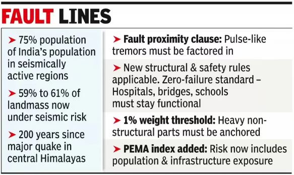
- Rising Exposure: Nearly three-fourths of India’s population now lives in seismically active regions, increasing disaster vulnerability.
- Global Practice Gap: The need to adopt Probabilistic Seismic Hazard Assessment (PSHA), used internationally, became imperative.
What is a Seismic Zonation Map?
A seismic zonation map divides a country into zones based on the expected intensity and frequency of earthquakes.
- Issued by the Bureau of Indian Standards (BIS)
- Integrated into IS 1893 (Earthquake Design Code)
- Forms the basis for urban planning, infrastructure design, and disaster preparedness
Key Features of the Seismic Zonation Map 2025
- Introduction of Zone VI:
- A new highest-risk zone created.
- The entire Himalayan arc from Jammu & Kashmir–Ladakh to Arunachal Pradesh, now falls under Zone VI, reflecting sustained extreme tectonic stress.
- Scientific Basis – PSHA:
- Uses Probabilistic Seismic Hazard Assessment, factoring in:
- Ground-shaking attenuation with distance
- Tectonic regime and fault behaviour
- Underlying lithology
- Uses Probabilistic Seismic Hazard Assessment, factoring in:
- Expanded High-Risk Coverage:
- 61% of India’s landmass now lies in moderate to high hazard zones (up from 59%).
- The Peninsular Plateau shows minor refinements, retaining a relatively stable seismic profile.
- Boundary Rule Enhancement: Towns located along zone boundaries will be assigned to the higher-risk zone.
- Focus on Non-Structural Safety: First-time emphasis on parapets, ceilings, overhead tanks, façade panels, lifts, electrical lines, and suspended fixtures.
- Near-Fault Provisions:
- Mandatory consideration of pulse-like ground motions near active faults.
- Updated limits on displacement, ductility, and energy dissipation.
- Site-Specific Requirements: New norms for liquefaction risk, soil flexibility, and response spectra.
- Critical Infrastructure Standards: Hospitals, schools, bridges, pipelines, and public utilities must remain functional after major earthquakes.
Implementation Challenges
- Retrofitting Existing Infrastructure: High costs, technical complexity, and coordination issues.
- Economic Impact: Stricter norms may increase construction costs.
- Technical Capacity: PSHA-based, site-specific designs require advanced geotechnical expertise and equipment.
Aravalli Hills
- 28 Nov 2025
In News:
The Supreme Court of India has accepted the recommendations of a Union Environment Ministry appointed committee on a uniform definition of the Aravalli Hills and Ranges, with the stated objective of restricting mining, prohibiting activity in core/inviolate areas, and enabling sustainable mining practices. The decision follows long-standing concerns over rampant legal and illegal mining in the Aravalli region.
Background
- The Aravalli Hills have faced decades of degradation due to mining and construction.
- In May 2024, the Supreme Court directed the Centre to evolve a uniform definition of the Aravallis, as the absence of clarity hindered effective regulation.
- Historically, the Forest Survey of India (FSI) used a 3-degree slope criterion (since 2010) to delineate Aravalli hills.
- A technical sub-committee (2024) later proposed identifying Aravalli hills as landforms with a minimum slope of 4.57 degrees (8%) and height of at least 30 m, which would have covered around 40% of the range.
New Definition Accepted by the Supreme Court
- Any landform with an elevation of 100 metres or more above local relief, along with its slopes and adjacent areas, will be considered part of the Aravalli Hills.
- As per internal FSI assessments:
- Only 1,048 hills (≈8.7%) out of over 12,000 hill features in Rajasthan meet the 100 m height criterion.
- Consequently, over 90% of the Aravalli landscape would fall outside the new definition.
Ecological Significance of the Aravalli Range
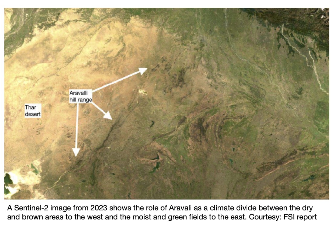
- The Aravalli Range stretches for about 692 km, from Gujarat to Delhi, via Rajasthan and Haryana; Rajasthan accounts for nearly two-thirds of its extent.
- It is the oldest mountain range in India and plays a vital role in:
- Acting as a barrier against desertification from the Thar Desert
- Regulating regional climate and air quality, especially in Delhi–NCR
- Serving as a watershed for rivers like Luni, Banas and Sabarmati
- Supporting biodiversity and wildlife corridors (e.g., Sariska–Ranthambhore)
Key Concerns with the New Definition
- Environmental impact: FSI cautioned that even low hills (10–30 m) function as crucial wind and dust barriers; their exclusion could worsen sand and dust transport toward the Indo-Gangetic plains and NCR.
- Methodological issues:
- Use of district-average slope and elevation masks the presence of local hill features.
- Comparing height above mean sea level with height above local relief leads to potential misclassification.
- Area exclusion: Several districts with known Aravalli features (e.g., Chittorgarh, Sawai Madhopur) were left out of the ministry’s Aravalli district list.
Way Forward
- While accepting the 100-m height definition, the Supreme Court has directed the Environment Ministry to prepare a Management Plan for Sustainable Mining, with technical support from the Indian Council of Forestry Research and Education (ICFRE).
- The plan aims to:
- Prevent illegal mining
- Regulate permitted mining sustainably
- Protect core/inviolate zones of the Aravalli ecosystem
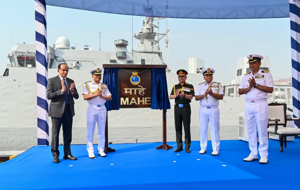
INS Mahe
- 28 Nov 2025
In News:
The Indian Navy commissioned INS Mahe, the first Mahe-class Anti-Submarine Warfare Shallow Water Craft (ASW-SWC), at the Naval Dockyard, Mumbai. With this induction, India has taken a significant step in strengthening its coastal and littoral anti-submarine warfare (ASW) capabilities under the Western Naval Command.
About INS Mahe
- Type: Anti-Submarine Warfare Shallow Water Craft (ASW-SWC)
- Class: Mahe-class (lead ship of eight vessels)
- Role: First line of coastal defence, designed to operate in shallow and near-shore waters
- Operational Command: Western Naval Command
INS Mahe is specially optimised to detect, track, and neutralise sub-surface threats in coastal regions where larger surface combatants face manoeuvrability constraints.
Design and Indigenous Content
- Designed & Built by: Cochin Shipyard Limited (CSL), Kochi
- Indigenisation: Over 80% indigenous content
- Industrial Ecosystem: Contributions from Bharat Electronics Limited, L&T Defence, Mahindra Defence Systems, NPOL, and more than 20 MSMEs
- A major milestone under Aatmanirbhar Bharat in naval shipbuilding
Key Features
- ASW Specialisation: Optimised for coastal and shallow water operations
- Advanced Combat Suite:
- Modern weapons
- High-precision sensors
- Secure and integrated communication systems
- Stealth & Endurance: Designed for prolonged operations in littoral waters
- Modern Machinery: Technologically advanced propulsion and integrated control systems
- Motto: “Silent Hunters” - reflecting stealth, vigilance, and readiness
Symbolism and Heritage
- Namesake: Historic coastal town of Mahe on the Malabar Coast
- Crest: Features the Urumi, the flexible sword of Kalaripayattu, symbolising agility and precision
- Mascot: Cheetah, representing speed and focus
Strategic Significance
- Boosts ASW Capability: Enhances India’s ability to counter submarine threats in littoral zones
- Strengthens Coastal Security Grid: Acts as the forward layer of a multi-tiered maritime defence architecture
- Force Multiplier: Integrates seamlessly with larger surface combatants, submarines, and naval aviation assets
- Indigenisation Push: Demonstrates India’s growing capacity to design, construct, and field complex naval combatants using domestic technology
IMF to Alter Classification of India’s Forex Framework

- 28 Nov 2025
In News:
The International Monetary Fund (IMF) has reclassified India’s de facto exchange rate regime from a “stabilised arrangement” to a “crawl-like arrangement”, reflecting the actual behaviour of the Indian rupee in the foreign exchange market rather than India’s official policy description.
What Has Changed?
- Earlier, India’s exchange rate was classified as stabilised, implying limited movement around a reference rate.
- The IMF now categorises it as crawl-like, meaning:
- The exchange rate remains within a ±2% band around a trend for at least six months.
- The currency is not fully market-determined, even though there is no formally announced crawl.
India’s Existing Exchange Rate Framework
- India officially follows a managed float system:
- The Reserve Bank of India (RBI) allows market forces to determine the broad trend of the rupee.
- RBI intervenes selectively to curb excessive volatility, maintain financial stability, and manage external sector risks.
- This differs from:
- Floating exchange rate: Fully market-determined with minimal intervention.
- Fixed exchange rate: Officially pegged and defended by the government/central bank.
Crawl-like Arrangement vs Crawling Peg
- Crawling Peg:
- Involves pre-announced, periodic adjustments in the exchange rate.
- Adjustments are often linked to indicators like inflation differentials.
- Crawl-like Arrangement (IMF classification):
- Based on observed currency behaviour, not on a declared policy.
- Indicates gradual and controlled movement of the currency, even without formal commitments.
How Does the IMF Classify Exchange Rate Regimes?
- Based on:
- IMF Articles of Agreement (foundational charter adopted in 1944 at the UN Monetary and Financial Conference).
- Article IV surveillance, under which IMF assesses:
- Actual exchange rate movements
- Scale and pattern of central bank intervention
- Degree of policy commitment to any exchange rate path
- The methodology is uniform across countries and focuses on de facto practices rather than de jure claims.