Goa Liberation Day

- 22 Dec 2025
In News:
Goa Liberation Day is commemorated on 19 December each year to mark the liberation of Goa from Portuguese colonial rule and its integration into the Indian Union. On this occasion, the Union Home Minister paid tributes to prominent freedom fighters such as Prabhakar Vaidya, Bala Raya Mapari, Nanaji Deshmukh, and Jagannath Rao Joshi, associated with the Goa liberation movement.
Portuguese Rule in Goa (1510–1961)
- Goa came under Portuguese control in 1510, after Afonso de Albuquerque defeated Yusuf Adil Shah of Bijapur.
- This began 451 years of Portuguese colonial rule, making Goa one of the longest-held European colonies in India.
- Until 1961, Indians required official permission to enter Goa, underscoring its separation from British India.
Rise of the Goa Liberation Movement
- Anti-colonial nationalism in Goa gained momentum alongside India’s freedom struggle.
- In 1928, Tristão de Bragança Cunha founded the Goa National Congress at the Calcutta session of the Indian National Congress, laying the ideological foundation for the movement.
- The movement suffered from a strategic split:
- Non-violent resistance (Satyagraha)
- Armed struggle, led by groups such as the Azad Gomantak Dal (AGD)
This divergence delayed unified mass mobilisation.
Role of National Leaders
- In 1946, socialist leader Ram Manohar Lohia led a historic rally in Goa demanding civil liberties, freedom, and integration with India, galvanising the movement at a critical juncture.
Integration with India: Operation Vijay
- After India’s independence, New Delhi initially avoided military action due to:
- Commitment to peaceful resolution
- Portugal’s membership in NATO
- With diplomatic efforts failing, India launched Operation Vijay in December 1961.
- On 19 December 1961, Goa, Daman, and Diu were liberated, ending Portuguese rule.
Post-Liberation Developments
- Goa, Daman, and Diu were initially constituted as Union Territories.
- In 1974, India and Portugal signed a treaty formally recognising India’s sovereignty over Goa, Daman & Diu, and Dadra & Nagar Haveli, restoring diplomatic relations.
- Goa attained full statehood on 30 May 1987, becoming India’s 25th state.
Pamir–Karakoram Anomaly

- 22 Dec 2025
In News:
Scientists are currently analysingdeep ice cores extracted from the Kon-Chukurbashi ice cap in Tajikistan to scientifically explain the Pamir–Karakoram anomaly, a rare glaciological phenomenon where glaciers have remained stable or even gained mass since the late 20th century, contrary to global trends of glacier retreat.
What is the Pamir–Karakoram Anomaly?
The Pamir–Karakoram anomaly describes the near-stability or slight expansion of glaciers in the Karakoram Range and parts of the Pamir Mountains, while glaciers in most other mountain systems, such as the Himalayas, Alps, Andes, and Rockieshave been rapidly shrinking due to rising global temperatures.
Geographical Extent
- Core region: Karakoram Range (notably Gilgit-Baltistan and parts of Ladakh)
- Extended region: Western Pamirs (Tajikistan and Afghanistan)
- This region lies at the junction of major mountain systems-Hindu Kush, Pamirs, Kunlun, and Himalayas.
Proposed Explanations
Several interacting factors are believed to contribute to this anomaly:
- Increased winter precipitation: Heavy snowfall during winters replenishes glacier mass and compensates for summer melting.
- Dominance of Western Disturbances: Unlike most of the Himalayas, this region receives moisture mainly from Western Disturbances rather than the Indian monsoon.
- High-altitude, steep topography: Promotes large accumulation zones and reduces exposure to solar radiation.
- Summer cloud cover: Limits incoming solar radiation, reducing melt rates.
- Debris-covered glaciers: Rock and sediment layers insulate underlying ice, slowing melting at lower elevations.
Recent Scientific Findings
- Satellite-based studies using ICESat-2 (altimetry) and GRACE (gravity data) suggest that the anomaly has weakened in recent years.
- However, field-based ice-core analysiswhich provides long-term climate records through trapped air bubbles, isotopes, and impuritiesis still underway and may offer deeper insights into historical snowfall and temperature patterns.
Significance for India
- Glaciers in the Karakoram are a major source of the Indus River system.
- Their relative stability ensures more reliable river flows into Ladakh and Jammu & Kashmir, supporting agriculture, hydropower, and water security.
- Understanding this anomaly is crucial for climate modelling, water-resource planning, and disaster risk assessment in the western Himalayas.
Karakoram Range: Key Facts
- Location: Central Asia; spans Afghanistan, China, India, Pakistan, and Tajikistan.
- Highest Peak:K2 (8,611 m), the world’s second-highest peak after Mount Everest.
- Known for extensive glaciation and some of the largest valley glaciers outside polar regions.
Bharat Taxi
- 22 Dec 2025
In News:
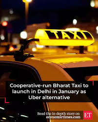
India is set to launch Bharat Taxi, the country’s first cooperative-run taxi service, in Delhi from 2027. Operated by Sahakar Taxi Cooperative Limited, the initiative aims to provide a homegrown, driver-first alternative to private cab aggregators such as Uber and Rapido, aligning with India’s broader push for cooperative-led growth and digital public infrastructure.
Key Features of Bharat Taxi
1. Cooperative Ownership & Governance
- Bharat Taxi is structured as a cooperative platform, ensuring drivers are stakeholders rather than gig workers.
- It seeks to curb profit extraction by intermediaries and promote equitable income distribution among drivers.
2. Commission Model
- Zero-commission model initially: 100% of ride payments go directly to drivers.
- A proposed ~20% cooperative fee may be introduced later, which will be redistributed back to drivers as incentives, unlike conventional aggregator commissions.
3. Institutional Collaboration
The platform is being developed through collaboration among:
- National e-Governance Division (NeGD)
- Digital India Corporation
- Ministry of Electronics and Information Technology (MeitY)
- Sahakar Taxi Cooperative Limited
This ensures integration with India’s Digital Public Infrastructure (DPI).
4. Digital Integration
Bharat Taxi will be integrated with:
- DigiLocker
- UMANG
- API Setu
These integrations will streamline driver onboarding, document verification, and service delivery.
5. Pricing Policy
- No surge pricing under normal conditions, enhancing affordability and predictability for commuters.
- Dynamic pricing permitted only under specific, clearly defined circumstances, unlike algorithm-driven surge pricing models.
6. Safety and Consumer Protection
- Driver verification and background checks.
- Integration with Delhi Police systems.
- Real-time ride tracking and 24×7 customer care, enhancing passenger safety and trust.
Significance
- Promotes the cooperative movement in the digital platform economy.
- Supports driver welfare, income stability, and transparency.
- Demonstrates the use of government-backed digital infrastructure for service delivery.
- Offers a public-interest alternative to profit-driven ride-hailing platforms.
Indian Coast Guard Ship Amulya
- 22 Dec 2025
In News:
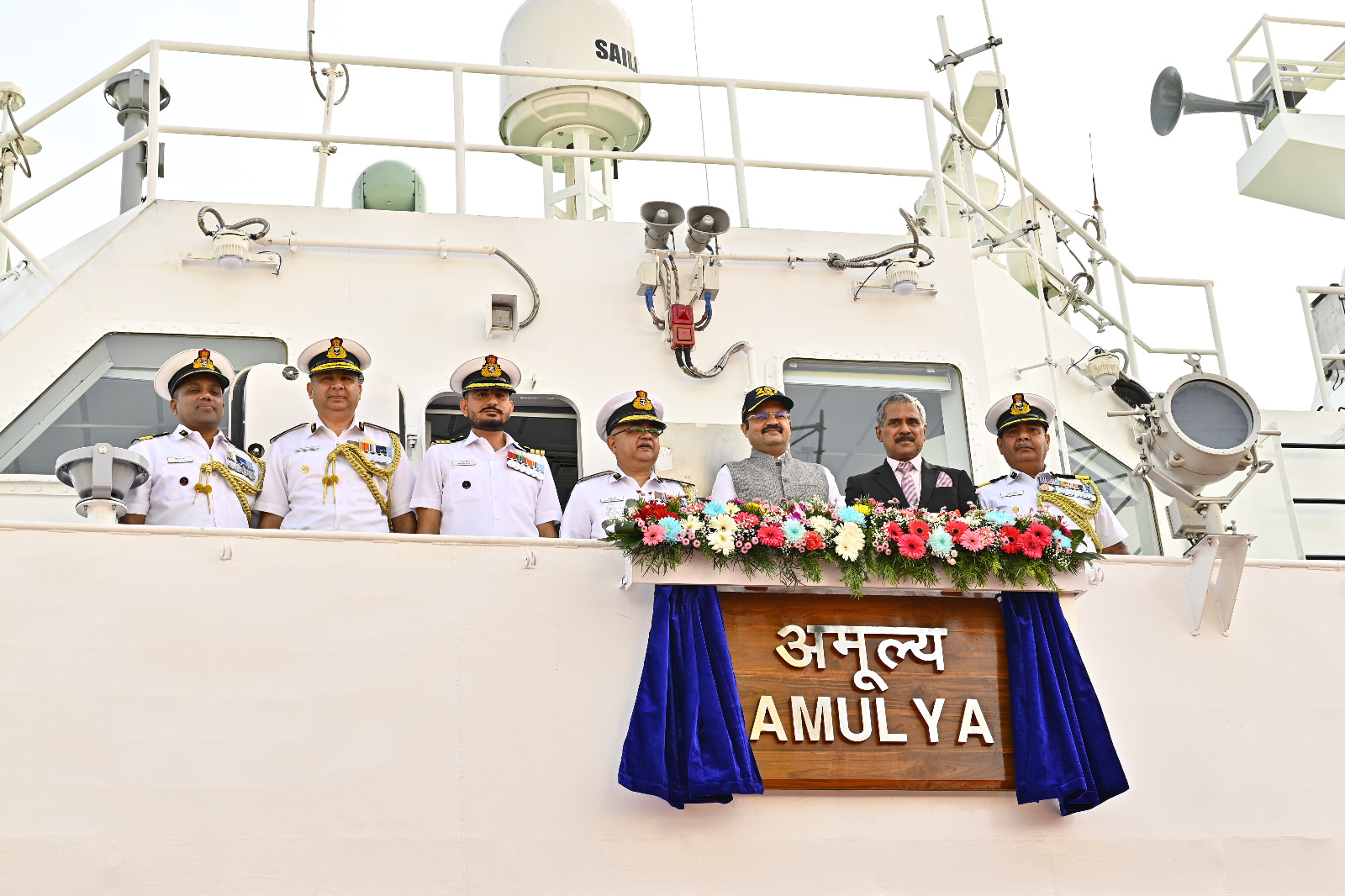
The Indian Coast Guard commissioned ICG Ship Amulya in Goa, marking another milestone in India’s efforts to enhance maritime security and indigenous defence capability. Amulya is the third vessel in the series of eight Adamya-class Fast Patrol Vessels (FPVs) being inducted into the Coast Guard fleet.
Design and Indigenous Content
- Amulya is a 51-metre-long Fast Patrol Vessel.
- Designed and built byGoa Shipyard Limited.
- Incorporates over 60% indigenous components, underscoring India’s push for defence self-reliance.
- Reflects the objectives of Aatmanirbhar Bharat and Make in India.
- Built with a modern design philosophy focused on efficiency, endurance, and rapid response.
Propulsion and Performance
- Propulsion: Powered by two 3000 kW advanced diesel engines.
- Top Speed:27 knots.
- Operational Endurance:1,500 nautical miles, enabling extended patrols across India’s maritime zones.
- Equipped with indigenous state-of-the-art weapons and systems, providing enhanced manoeuvrability, flexibility, and operational performance at sea.
Roles and Functions
ICG Ship Amulya is designed to undertake a wide range of coast guard missions, including:
- Maritime surveillance and interdiction
- Search and Rescue (SAR) operations
- Anti-smuggling and law enforcement
- Marine pollution response
These roles are critical for safeguarding India’s coastline, maritime trade routes, and offshore assets.
Operational Deployment
- Home Port: Paradip, Odisha
- Operates under the administrative and operational control of the Commander, Coast Guard Region (North East).
- Its deployment strengthens surveillance and response capabilities along the eastern seaboard.
Doppler Weather Radar (DWR)
- 22 Dec 2025
In News:
The Government of India has informed Parliament that 47 Doppler Weather Radars (DWRs) are currently operational across the country, covering nearly 87% of India’s geographical area. These radars play a crucial role in monitoring weather systems and improving forecasts of extreme weather events, significantly strengthening India’s disaster preparedness and early warning capabilities.
What is a Doppler Weather Radar?
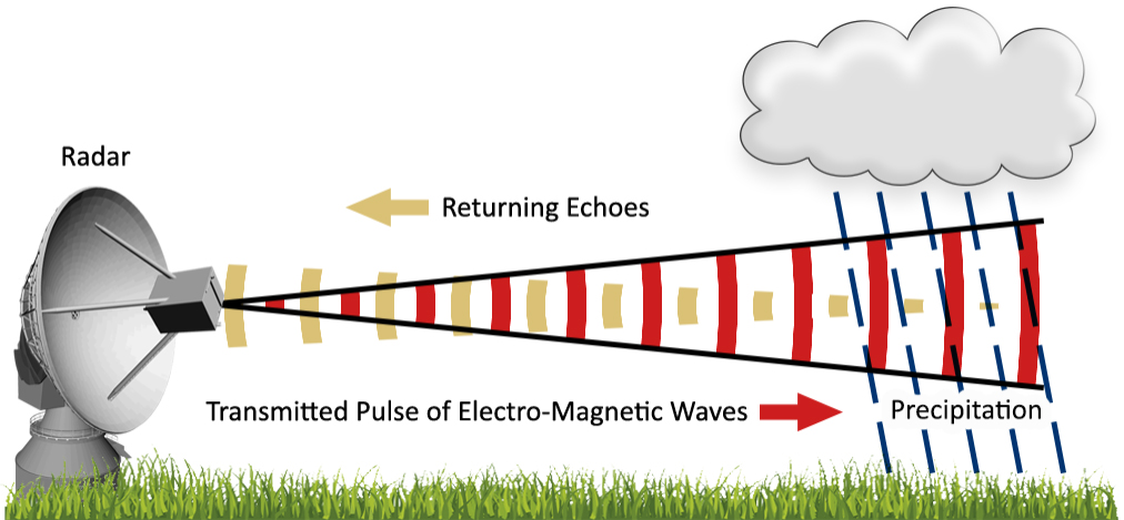
A Doppler Weather Radar is an advanced meteorological instrument that uses the Doppler effect—identified by Christian Doppler—to determine both the position and velocity of atmospheric targets such as raindrops, snowflakes, or hailstones. The Doppler effect explains how the frequency of a wave changes relative to the motion of the source or observer (similar to the changing pitch of a passing train whistle).
Unlike conventional radars that only detect the location of precipitation, DWRs can also measure movement, enabling more accurate tracking of storms and cloud systems.
How Doppler Weather Radars Work
- The radar emits pulses of radio waves from an antenna.
- When these waves strike atmospheric particles, a portion of the energy is scattered back to the radar.
- The time taken for the signal to return helps calculate the distance of precipitation.
- The change in frequency or phase of the returned signal (Doppler shift) reveals the speed and direction of movement of weather systems.
- Larger particles reflect more energy, allowing estimation of rainfall intensity.
Radar Bands Used in India
The India Meteorological Department (IMD) employs different radar frequency bands based on application:
- S-band: Long-range surveillance and cyclone monitoring
- C-band: Widely used for cyclone tracking and regional weather observation
- X-band: Short-range, high-resolution detection of thunderstorms and lightning
Applications of Doppler Weather Radars
- Detection of precipitation: Rain, snow, hail
- Tracking movement of clouds and storms
- Estimation of rainfall intensity and distribution
- Nowcasting: Short-term forecasts of extreme events like cloudbursts, thunderstorms, squalls, and cyclones
- Coverage: Each radar can monitor weather within a radius of about 500 km