Scarborough Shoal
- 16 Apr 2026
In News:
Recent satellite imagery confirmed a significant escalation at the Scarborough Shoal, as China deployed floating barriers and an increased fleet of Coast Guard and maritime militia vessels to block the entrance to the atoll’s lagoon. This move, aimed at tightening de facto control over the disputed feature, has reignited diplomatic and security concerns between Manila and Beijing, making it a critical case study for international maritime law and regional geopolitics.
I. Geographical and Strategic Profile
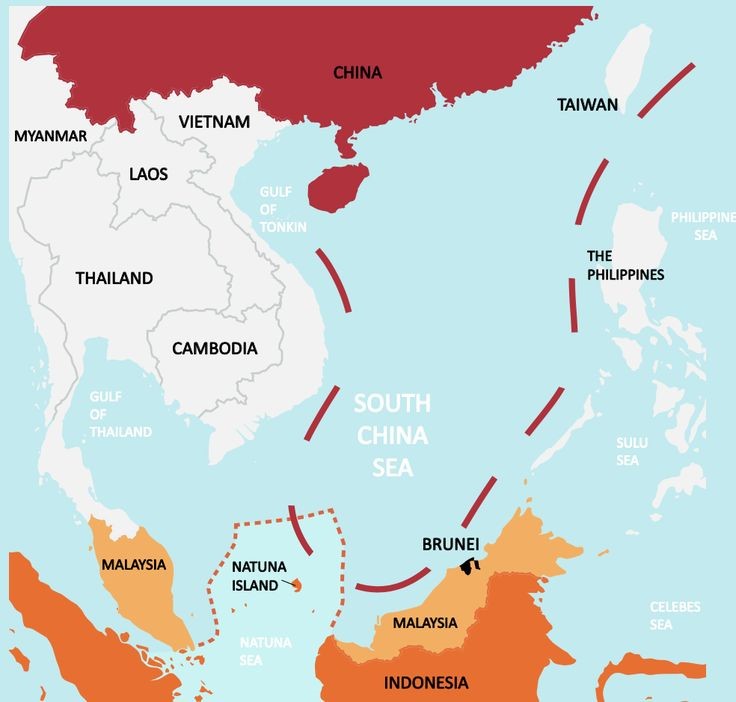
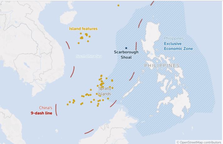
- Location: Situated in the eastern South China Sea, approximately 120 nautical miles (222 km) west of Luzon (Philippines) and about 470 nautical miles from the Chinese coast.
- Physical Character: It is a triangular coral atoll formed on an underwater volcanic mount, covering an area of 150 sq. km. It is not a permanent island but a high-tide feature where several rocks (notably "South Rock") remain above water at high tide.
- Nomenclature: Known as Bajo de Masinloc or Panatag Shoal in the Philippines, and Huangyan Island in China. It was named after the HMS Scarborough, an East India Company ship that struck the reef in the 18th century.
- Economic Value: The shoal serves as a traditionally rich fishing ground for local communities (particularly from Zambales) and is believed to harbor significant seabed mineral resources, including petroleum and natural gas.
II. The Legal and Territorial Dispute
The conflict involves overlapping claims based on disparate legal and historical interpretations:
|
Feature |
The Philippines' Claim |
China’s Claim |
|
Legal Basis |
Based on UNCLOS (1982); the shoal lies within the Philippines' 200-nautical-mile Exclusive Economic Zone (EEZ). |
Claims "historical rights" dating back to the Yuan Dynasty (1200s) and the controversial Nine-Dash Line. |
|
Current Status |
Maintains legal rights reinforced by the 2016 Permanent Court of Arbitration (PCA) ruling. |
Maintains de facto control since a 2012 standoff, despite the 2016 ruling invalidating its expansive claims. |
|
Recent Strategy |
Protesting "barrier diplomacy" and seeking international support. |
Using the "Nature Reserve" pretext to justify permanent presence and potential artificial construction. |
III. Key Conflict Drivers (2026 Context)
- Barrier Diplomacy: China’s use of floating barriers is a tactical maneuver to deny Filipino fishermen access to the lagoon, effectively weaponizing maritime infrastructure.
- Militarization & Grey Zone Tactics: The deployment of the "Maritime Militia"—fishing trawlers acting as paramilitary units—allows China to project power while staying below the threshold of direct military conflict.
- Legal Pretexts: Manila views China's recent declaration of the area as a "national nature reserve" as a sophisticated legal strategy to normalize permanent occupation and provide a facade for future construction.
IV. Broader Geopolitical Implications
- U.S.-Philippines Alliance: Under the U.S.-Philippines Mutual Defense Treaty, an armed attack on Philippine vessels or personnel could necessitate U.S. intervention. China’s current blockade tests the "red lines" of this alliance.
- Regional Stability: Diplomats fear that China is capitalizing on global distractions (such as conflicts in the Middle East) to shift the status quo in the South China Sea.
- Livelihood Security: The blockade creates significant economic distress for Filipino coastal provinces, transforming a territorial dispute into a socio-economic crisis for local populations.
Scarborough Shoal Dispute
- 14 Sep 2025
In News:
The Scarborough Shoal, a triangular atoll in the South China Sea, has once again become a flashpoint after China announced the establishment of a 3,524-hectare nature reserve in the disputed waters. The move has drawn strong protests from the Philippines, which claims sovereignty over the feature and views China’s step as an assertion of jurisdiction under the guise of ecological protection.
Geographical and Strategic Significance
- The shoal is located about 220 km west of the Philippines’ Luzon Island and falls well within Manila’s 200-nautical mile Exclusive Economic Zone (EEZ) under the 1982 UN Convention on the Law of the Sea (UNCLOS).
- Claimed by both China (which calls it Huangyan Island) and the Philippines (locally known as Panatag Shoal or Bajo de Masinloc), sovereignty over the shoal remains unsettled.
- Its location near major global shipping lanes that carry over $3 trillion worth of trade annually enhances its geostrategic value.
- The lagoon and surrounding waters are rich in fish stocks, shellfish, and sea cucumbers, making it a vital fishing ground for regional communities.
Historical and Legal Context
- China’s claim: Traced back to maps from the Yuan Dynasty (1200s), Beijing argues historical sovereignty.
- Philippines’ claim: Based on proximity, falling within its EEZ, and backed by the 2016 Permanent Court of Arbitration (PCA) ruling under UNCLOS, which invalidated China’s “nine-dash line” claim. The ruling, however, did not adjudicate on sovereignty but recognized the shoal as a traditional fishing ground for multiple nations.
- Control: China seized effective control of the shoal in 2012 after a naval standoff and has since maintained coast guard and fishing militia presence, often intercepting Filipino vessels.
China’s Nature Reserve Plan
- China has approved a marine protected area to conserve the coral reef ecosystem of the shoal.
- Chinese officials argue it reflects improved “jurisdiction and governance” and claim Filipino fishermen are responsible for overfishing and pollution.
- Critics, however, view the reserve as a political instrument to strengthen Chinese control and potentially restrict access to Filipino fishermen under the pretext of conservation.
- The Philippines has accused China of coral destruction and giant clam harvesting, raising the possibility of fresh international arbitration on environmental grounds.
Regional and Global Reactions
- Philippines: Strongly protested the move, viewing it as a violation of its sovereign rights. President Ferdinand Marcos Jr. has leveraged the issue domestically while deepening ties with the United States.
- United States: Condemned the reserve plan as “destabilising and coercive.” Under the 1951 Mutual Defence Treaty, Washington has pledged to defend the Philippines against armed attacks, including those occurring “anywhere in the South China Sea.”
- Risk of escalation: Recent incidents—such as the use of water cannons, ramming of boats, and close aerial encounters—underline the danger of miscalculation, though both sides avoid direct combat to prevent escalation.
- Expert views: Chinese analysts frame the reserve as ecological protection, while Philippine experts argue it is a strategic tool to consolidate Beijing’s de facto control and marginalize other claimants.
Implications
- For the Philippines:
- Raises questions about maritime security and economic livelihood of fishermen.
- Strengthens its reliance on the U.S. alliance for deterrence.
- For China:
- Enhances its long-term maritime footprint and jurisdictional claims.
- Risks further international pushback, reinforcing perceptions of coercion.
- For International Order:
- Challenges the enforcement of UNCLOS and undermines multilateral dispute settlement mechanisms.
- Escalates tensions in one of the world’s busiest waterways with direct implications for global trade.