Christmas Island

- 11 Nov 2025
In News:
Google has proposed establishing an artificial intelligence–enabled data centre on Christmas Island, a remote Australian territory in the Indian Ocean. The proposal follows a cloud services agreement between Google and Australia’s Department of Defence, underscoring the growing intersection of digital infrastructure, defence preparedness, and geopoliticsin the Indo-Pacific region.
About Christmas Island
- Location: Indian Ocean; about 360 km south of Java (Indonesia) and 1,400 km northwest of mainland Australia.
- Administrative status: External territory of Australia.
- Physical geography: Volcanic origin; summit of an oceanic mountain. Highest point is Murray Hill (361 m).
- Main settlement and port: Flying Fish Cove (north-eastern coast).
- Area & population: ~135 sq km; population around 1,600.
Ecological Features
- Dominated by tropical rainforest.
- Rich biodiversity with seabirds, reptiles, insects, and land crabs.
- Famous for the annual mass migration of the Christmas Island red crab (Gecarcoideanatalis), a major tourist attraction.
Historical Background
- Sighted by Europeans in 1615; named in 1643.
- Phosphate deposits discovered in 1887, leading to British annexation.
- Incorporated into the Straits Settlements in 1900.
- Occupied by Japan during World War II.
- Transferred to Australia in 1958.
Economy
- Historically dependent on phosphate mining (now nearly exhausted).
- Ongoing efforts to diversify through tourism.
- Limited local agriculture and fishing; heavy reliance on imports.
Google’s AI Data Centre Proposal
- Google is in discussions to lease land near the island’s airport to build a data facility.
- The project is linked to subsea cable infrastructure, including:
- A proposed cable connection between Christmas Island and Darwin.
- Future connectivity to Asia, enhancing digital resilience in the Indo-Pacific.
- Energy needs are expected to be met through a mix of diesel and renewable sources, raising concerns about local supply sustainability.
Strategic and Defence Significance
- Christmas Island is increasingly viewed as a strategic frontline outpost for monitoring maritime activity in the Indian Ocean.
- Its location offers surveillance advantages over key sea lanes such as the Sunda, Lombok, and Malacca Straits.
- Defence analysts suggest that a local data centre could support AI-enabled military command and control, especially for:
- Uncrewed systems (drones)
- Surveillance and targeting
- Subsea cables provide more reliable and high-bandwidth communication than satellites, which may be vulnerable during conflicts.
Community and Environmental Concerns
- Local authorities are assessing:
- Impact on energy availability
- Environmental safeguards in a biodiversity-rich island
- Potential benefits in terms of employment, infrastructure, and economic diversification
- The Australian government has stated that environmental and planning approvals are mandatory before project clearance.
Japan Elects First Female Prime Minister

- 22 Oct 2025
In News:
- Recently, Japan’s National Diet elected Sanae Takaichi as its new Prime Minister, making her the first woman to hold that office in the nation’s history.
- Her ascent comes amid a shifting political backdrop, as the long-governing Liberal Democratic Party (LDP) lost its outright majority and secured a coalition with the Japan Innovation Party (Ishin).
Her appointment is notable not only for the gender milestone but also for signaling a potential policy shift—especially in Japan’s defence, economy and Indo-Pacific diplomacy.
Structural & Governance-Related Aspects
- Japan is a parliamentary constitutional monarchy. The Prime Minister is the real executive authority and is accountable to the lower house (House of Representatives).
- Her government is a minority coalition: the LDP formed an alliance with the Japan Innovation Party after the LDP-Komeito coalition collapsed. Thus, the new administration lacks a comfortable majority and will face legislative challenges.
- Despite her historic election, her cabinet contains only two women, raising questions about the depth of the gender-breaking moment for Japanese politics.
Key Challenges Ahead
- Economic recovery – Japan faces slow growth, inflationary pressures and demographic headwinds. Takaichi has pledged stimulus measures along the lines of previous “Abenomics”-style policies.
- Defence & security – With rising regional tensions, she is expected to push for higher defence spending and deeper coordination with the U.S. and Quad partners. Her first face-to-face diplomatic test includes welcoming U.S. President Donald Trump.
- Gender & social policy expectations – While she broke a barrier as Japan’s first female PM, her conservative positions on issues like same-sex marriage, imperial succession and women’s representation have drawn criticism.
- Policy implementation in a fragmented parliament – With no clear majority, passing major reforms will require coalition-building or compromises with opposition parties, marking a potential shift from LDP’s dominance.
Significance for India and the Indo-Pacific
From the Indian perspective—relevant to GS Paper II on International Relations—Takaichi’s election holds importance:
- Japan remains a key partner for India in the Indo-Pacific region, including in frameworks such as the Quad and supply-chain resilience initiatives.
- Her commitment to stronger defence and security cooperation with allies resonates with India’s own strategic concerns in the Indo-Pacific maritime domain.
- A stable, assertive Japan aligns with India’s interest in sustaining a free, open and rules-based maritime order.
Scarborough Shoal Dispute
- 14 Sep 2025
In News:
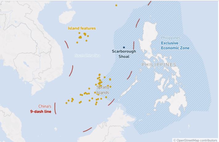
The Scarborough Shoal, a triangular atoll in the South China Sea, has once again become a flashpoint after China announced the establishment of a 3,524-hectare nature reserve in the disputed waters. The move has drawn strong protests from the Philippines, which claims sovereignty over the feature and views China’s step as an assertion of jurisdiction under the guise of ecological protection.
Geographical and Strategic Significance
- The shoal is located about 220 km west of the Philippines’ Luzon Island and falls well within Manila’s 200-nautical mile Exclusive Economic Zone (EEZ) under the 1982 UN Convention on the Law of the Sea (UNCLOS).
- Claimed by both China (which calls it Huangyan Island) and the Philippines (locally known as Panatag Shoal or Bajo de Masinloc), sovereignty over the shoal remains unsettled.
- Its location near major global shipping lanes that carry over $3 trillion worth of trade annually enhances its geostrategic value.
- The lagoon and surrounding waters are rich in fish stocks, shellfish, and sea cucumbers, making it a vital fishing ground for regional communities.
Historical and Legal Context
- China’s claim: Traced back to maps from the Yuan Dynasty (1200s), Beijing argues historical sovereignty.
- Philippines’ claim: Based on proximity, falling within its EEZ, and backed by the 2016 Permanent Court of Arbitration (PCA) ruling under UNCLOS, which invalidated China’s “nine-dash line” claim. The ruling, however, did not adjudicate on sovereignty but recognized the shoal as a traditional fishing ground for multiple nations.
- Control: China seized effective control of the shoal in 2012 after a naval standoff and has since maintained coast guard and fishing militia presence, often intercepting Filipino vessels.
China’s Nature Reserve Plan
- China has approved a marine protected area to conserve the coral reef ecosystem of the shoal.
- Chinese officials argue it reflects improved “jurisdiction and governance” and claim Filipino fishermen are responsible for overfishing and pollution.
- Critics, however, view the reserve as a political instrument to strengthen Chinese control and potentially restrict access to Filipino fishermen under the pretext of conservation.
- The Philippines has accused China of coral destruction and giant clam harvesting, raising the possibility of fresh international arbitration on environmental grounds.
Regional and Global Reactions
- Philippines: Strongly protested the move, viewing it as a violation of its sovereign rights. President Ferdinand Marcos Jr. has leveraged the issue domestically while deepening ties with the United States.
- United States: Condemned the reserve plan as “destabilising and coercive.” Under the 1951 Mutual Defence Treaty, Washington has pledged to defend the Philippines against armed attacks, including those occurring “anywhere in the South China Sea.”
- Risk of escalation: Recent incidents—such as the use of water cannons, ramming of boats, and close aerial encounters—underline the danger of miscalculation, though both sides avoid direct combat to prevent escalation.
- Expert views: Chinese analysts frame the reserve as ecological protection, while Philippine experts argue it is a strategic tool to consolidate Beijing’s de facto control and marginalize other claimants.
Implications
- For the Philippines:
- Raises questions about maritime security and economic livelihood of fishermen.
- Strengthens its reliance on the U.S. alliance for deterrence.
- For China:
- Enhances its long-term maritime footprint and jurisdictional claims.
- Risks further international pushback, reinforcing perceptions of coercion.
- For International Order:
- Challenges the enforcement of UNCLOS and undermines multilateral dispute settlement mechanisms.
- Escalates tensions in one of the world’s busiest waterways with direct implications for global trade.
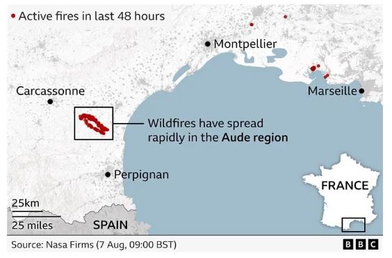
France’s Largest Wildfire in Decades
- 09 Aug 2025
In News:
Recently, southern France witnessed its worst wildfire since 1949, scorching nearly 16,000 hectares (39,500+ acres) of forests and villages—an area 1.5 times the size of Paris. Though the blaze has now been contained, firefighters remain deployed to prevent flare-ups and secure the affected zone.
Causes and Challenges
- Climatic Drivers: Officials and France’s Environment Minister attributed the fire’s intensity to climate change, prolonged drought, strong winds, and extremely dry vegetation.
- Geographic Factors: Proximity to the Pyrenees mountains and the Mediterranean coast made the terrain vulnerable to rapid fire spread. Loss of traditional vineyards and land-use changes further accelerated the blaze.
- Future Risks: France’s weather office has warned of fresh heatwaves, increasing wildfire vulnerability across southern Europe.
Geographic Overview of France
- Location: Northern & Eastern Hemispheres; bordered by Belgium, Luxembourg, Germany, Switzerland, Italy, Spain, Andorra.
- Water Bodies: Bounded by the Bay of Biscay (west), English Channel (northwest), and Mediterranean Sea (south).
- Major Rivers:Loire (into Atlantic), Seine (into English Channel).
- Mountain Ranges:Alps, Jura, and Pyrenees (natural border with Spain).
- Resources: Coal, iron ore, bauxite, zinc, uranium, potash, gypsum, etc.
- Overseas Regions: Guadeloupe, French Guiana, Réunion, Martinique, Mayotte.
- Capital: Paris.
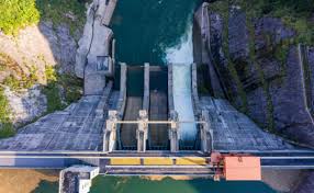
China approves construction of World’s Largest Hydropower Dam on the Brahmaputra River
- 28 Dec 2024
In News:
China approved the construction of the world's largest dam, stated to be the planet's biggest infra project, on the Brahmaputra river in Tibet close to the Indian border, raising concerns in India and Bangladesh.
Key highlights:
Overview of the Project:
- Location: Lower reaches of the Yarlung Zangbo River (Tibetan name for Brahmaputra), where the river makes a U-turn in the Himalayan region before flowing into Arunachal Pradesh, India.
- Purpose:
- To support China’s carbon neutrality goals.
- To boost industrial growth and create jobs in Tibet.
- Expected to generate 300 billion kWh of electricity annually, over three times the capacity of the Three Gorges Dam in central China.
Significance:
- Scale: The dam is poised to be the world’s largest hydropower project, surpassing the Three Gorges Dam, and becoming the biggest infrastructure project globally, with an estimated cost of USD 137 billion.
- Engineering Challenges: The site is located in a seismic zone on the Tibetan plateau, prone to earthquakes, making construction and operational stability a major engineering challenge.
Concerns:
- Environmental Impact:
- Potential disruption to the local ecosystem and biodiversity.
- Risk of altering the river’s flow and course, which could impact agriculture and water resources downstream, particularly in India and Bangladesh.
- Geopolitical Risks:
- Water control: India and Bangladesh are concerned about China’s ability to control the water flow, with fears of China manipulating the flow to release excess water during conflicts, causing potential flooding in border areas.
- The project could also disrupt the hydrological cycle, affecting the region’s water availability, especially in Assam and Bangladesh.
Background:
- The Brahmaputra River is a trans-boundary river, flowing through China, India, and Bangladesh. Known by different names in these countries, it plays a vital role in the livelihoods of millions of people.
- China has already initiated hydropower generation on the upper reaches of the Yarlung Zangbo, with plans for additional projects upstream.
India-China Cooperation:
- China and India have an Expert Level Mechanism (ELM) in place since 2006 to manage trans-boundary river issues, under which China shares hydrological data with India, especially during the flood season.
- India is also constructing its own hydropower projects on the Brahmaputra in Arunachal Pradesh.
Potential Outcomes:
- Energy Generation: The dam could significantly contribute to China’s energy needs, providing a substantial amount of renewable energy.
- Regional Tensions: The dam’s construction may escalate tensions between China, India, and Bangladesh due to the control over water resources and environmental impact concerns.