NAKSHA Programme
- 22 Feb 2025
In News:
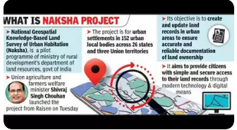
The Union Ministry of Rural Development has launched a pilot project titled NAKSHA(National Geospatial Knowledge-based Land Survey of Urban Habitations) in 152 Urban Local Bodies (ULBs) across 26 States and 3 Union Territories, with the inauguration taking place in Raisen, Madhya Pradesh.
Key Highlights:
Objective of NAKSHA
The NAKSHA initiative aims to:
- Create and update urban land records for accurate, reliable documentation of property ownership.
- Empower citizens by improving ease of access to land records.
- Facilitate urban planning and reduce land-related disputes.
- Promote transparency, efficiency, and sustainable development through an IT-based system.
Key Features
- Technical Partner: The Survey of India will carry out aerial surveys and provide orthorectified imagery via third-party vendors.
- Implementation Partners:
- Madhya Pradesh State Electronics Development Corporation (MPSEDC) will develop a web-based GIS platform.
- National Informatics Centre Services Inc. (NICSI) will provide data storage facilities.
- Execution at State Level: States and UTs will conduct field surveys and ground truthing, leading to the final publication of urban and semi-urban land records.