Iran-Pakistan-India (IPI) Pipeline
- 23 Mar 2026
In News:
The ongoing geopolitical tensions in West Asia have disrupted global energy supply chains, exposing India’s high dependence on imported hydrocarbons, particularly natural gas. This has revived discussions around stalled transnational pipeline projects such as the Iran–Pakistan–India (IPI) and Turkmenistan–Afghanistan–Pakistan–India (TAPI) pipelines as alternatives to ensure long-term energy security.
Background: India’s Energy Vulnerability
India is heavily reliant on imports to meet its energy needs, especially for natural gas. Disruptions in maritime routes and geopolitical instability in West Asia increase price volatility and supply risks, highlighting the need for diversified and secure energy sources.
Pipeline-based supply was envisioned as a cost-effective and stable alternative to Liquefied Natural Gas (LNG), reducing dependence on sea routes and global spot markets.
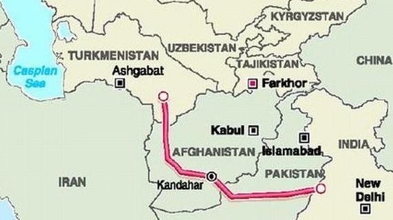
Iran–Pakistan–India (IPI) Pipeline
- The IPI pipeline, often referred to as the “Peace Pipeline,” was conceptualised in the 1990s to transport natural gas from Iran’s South Pars field to South Asia.
- The project envisaged a 2,775 km pipeline supplying around 60 mmscmd of gas each to India and Pakistan, offering a relatively cheaper alternative to LNG imports. It also carried the promise of regional cooperation through economic interdependence.
- However, the project lost momentum and India withdrew in 2007 due to multiple concerns. These included U.S.-led sanctions on Iran, pricing disagreements, and security risks, particularly regarding the pipeline’s passage through Pakistan’s Balochistan region. As a result, the project remains effectively dormant.
Turkmenistan–Afghanistan–Pakistan–India (TAPI) Pipeline
- Following the stagnation of IPI, India shifted its focus to the TAPI pipeline, which aimed to bring natural gas from the Galkynysh gas field in Turkmenistan, one of the world’s largest reserves.
- Spanning about 1,814 km, the pipeline is designed to transport 33 billion cubic meters (bcm) of gas annually. It received support from the Asian Development Bank and was seen as part of broader efforts to integrate Central and South Asia economically.
- While progress has been made in parts of the project—particularly the Turkmenistan-Afghanistan section—the extension into Pakistan and India remains stalled due to security challenges in Afghanistan, financing constraints, and geopolitical uncertainties.
Comparative Analysis
The IPI and TAPI pipelines reflect two different strategic approaches to energy security. While IPI relied on West Asian resources with shorter routes, it faced geopolitical constraints. TAPI, on the other hand, sought to diversify supply through Central Asia, but has struggled due to instability along its transit route.
Both projects highlight the complexity of cross-border energy infrastructure, where geopolitics, security, and economic viability intersect.
Missile Defence in the US-Israel-Iran Conflict

- 03 Mar 2026
In News:
Recent tensions in West Asia, particularly involving the United States, Israel, and Iran, have highlighted the growing importance of missile defence systems in contemporary warfare. The increasing use of ballistic missiles, cruise missiles, and armed drones has compelled countries to develop multi-layered air defence architectures capable of detecting, tracking, and intercepting hostile projectiles before they reach their targets. These systems play a crucial role not only in protecting civilian infrastructure and military installations but also in strengthening deterrence and strategic stability.
What is a Missile Defence System?
A missile defence system is an integrated military architecture designed to detect, track, and destroy incoming missiles or aerial threats before impact. Such systems combine advanced sensors, command networks, and interceptor missiles to neutralise threats during different phases of flight.
Key Components
- Sensors and Detection Systems:
- Satellites and ground-based radar stations continuously monitor the sky.
- They detect launches and track the speed, altitude, and trajectory of incoming threats.
- Command and Control Centres:
- Advanced computing systems process sensor data.
- Military operators assess whether the object is a threat and determine the appropriate defensive response.
- Interceptor Missiles: These are defensive missiles launched to destroy the incoming projectile mid-air.
Strategic Importance
Missile defence systems serve multiple purposes:
- Protection of lives and infrastructure by neutralising aerial threats.
- Deterrence, as adversaries may hesitate to launch attacks if interception is likely.
- Decision-making time, allowing governments and military authorities to evaluate response options during crises.
How Missile Interceptors Work
The functioning of missile interceptors involves several coordinated stages:
- Detection and Tracking: Ground-based radar scans the sky by emitting radio beams. When these signals bounce off an object, computers analyse the reflection to determine its speed, altitude, and trajectory.
- Target Locking: If the object is identified as a threat, the radar focuses on it, continuously updating its location.
- Launch of Interceptor: A command centre calculates the interception trajectory and instructs the launcher system to fire the interceptor missile.
- Mid-course Guidance: Radar tracks both the incoming missile and the interceptor, transmitting guidance signals to ensure the interceptor moves toward the target.
- Terminal Phase Destruction: In the final stage, the interceptor uses onboard sensors (seekers) to precisely locate the target and destroy it using either:
- Proximity fuse: detonates a warhead near the target to destroy it with shrapnel.
- Hit-to-kill technology: directly collides with the target using kinetic energy, a method used in many modern systems.
Major Missile Defence Systems in the US–Israel–Iran Theatre
United States
The United States deploys multiple interceptor systems forming a layered defence network:
- THAAD (Terminal High Altitude Area Defense): Intercepts short- and intermediate-range ballistic missiles during the terminal phase at high altitudes using hit-to-kill technology.
- Patriot Missile System: Provides point defence against ballistic missiles, cruise missiles, and aircraft, widely used to protect military bases and critical infrastructure.
- SM-3 and SM-6 (US Navy): Sea-based interceptors launched from naval vessels.
- SM-3: Targets ballistic missiles during the mid-course phase outside the atmosphere.
- SM-6: Engages aircraft, missiles, and drones in the terminal phase.
- Indirect Fire Protection Capability (IFPC): Uses AIM-9X interceptors to counter rockets, artillery shells, and drones while conserving expensive missile defence systems like Patriot.
Israel
Israel maintains one of the world’s most sophisticated multi-layered air defence systems:
- Arrow-3: Intercepts long-range ballistic missiles outside the atmosphere.
- Arrow-2: Engages ballistic missiles within the atmosphere.
- David’s Sling: Designed to intercept medium- and long-range rockets, cruise missiles, and tactical ballistic missiles.
- Iron Dome: Highly effective short-range defence system used to intercept rockets, artillery shells, and drones.
- Iron Beam: A laser-based directed energy system aimed at destroying drones and small projectiles at relatively low cost.
Iran
Iran has developed indigenous and imported air defence systems to counter aerial threats:
- Bavar-373: Long-range air defence system capable of intercepting aircraft and ballistic missiles.
- Sevom-e-Khordad: Mobile system targeting aircraft and cruise missiles, improving survivability through mobility.
- Tor-M1: Short-range defence system used to intercept drones and precision-guided munitions.
- Majid and Azarakhsh: Systems designed primarily to counter drones and low-flying aerial threats.
United Arab Emirates
- Cheongung II: A South Korean medium-range air defence system featuring 360-degree radar coverage and vertical launch capability, designed to intercept cruise missiles and tactical ballistic threats.
Exercise Suryakiran

- 27 Nov 2025
In News:
India and Nepal are conducting the 19th edition of the bilateral military exercise Suryakiran from 25 November to 8 December in Pithoragarh, Uttarakhand. The exercise reflects the deep-rooted defence cooperation and operational coordination between the Indian Army and the Nepal Army.
About Exercise Suryakiran
- Nature: Bilateral, annual, battalion-level joint military exercise
- Participating Countries: India and Nepal
- Frequency & Venue: Conducted annually, alternately in India and Nepal
- Last Edition: 18th edition held at Saljhandi, Nepal (Dec 2024–Jan 2025)
Objectives
- Enhance operational synergy in jungle warfare and mountain warfare
- Strengthen cooperation in counter-terrorism operations
- Improve interoperability through integration of niche and modern technologies
- Exchange best practices, tactical doctrines, and operational experiences
Key Features
- High-Altitude & Jungle Warfare Training: Joint drills in forested and mountainous terrain, mirroring Himalayan operational conditions.
- Counter-Terrorism Modules: Includes cordon-and-search operations, room intervention, surveillance, and small-team tactics.
- Technology Integration: Use of modern surveillance systems, secure communications, drones, medical evacuation, and battlefield support tools.
- Comprehensive Participation: Battalion-sized contingents (around 300+ personnel) including specialists in aviation, medical, engineering, and high-altitude warfare.
- Professional Exchange: Platform for soldiers to share combat experiences, survival skills, and standard operating procedures.
Strategic Significance
- Reinforces long-standing military ties based on mutual trust, respect, and historical linkages.
- Helps standardise operational procedures and communication protocols for joint missions.
- Enhances preparedness for counter-terrorism, border security, and disaster response in the Himalayan region.
- Contributes to regional stability and shared commitment to peace and security.
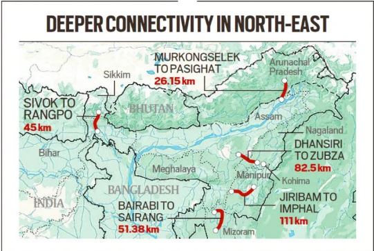
Bairabi–Sairang Project
- 17 Sep 2025
In News:
The inauguration of Mizoram’s first-ever railway line — the Bairabi–Sairang Broad-Gauge Project — marks a historic milestone in the state’s connectivity and India’s Act East Policy. Prime Minister Narendra Modi inaugurated the 51.38-km line, constructed at a cost of ?8,070 crore, connecting Mizoram’s capital Aizawl to the national railway network for the first time.
A 15-Year Vision Realised
- Sanctioned in 2008–09 and launched for construction in 2015, the project exemplifies one of the most complex undertakings of the Indian Railways due to Mizoram’s mountainous terrain and fragile geology.
- Nearly 54% of the alignment passes through tunnels and bridges, making it a remarkable feat of engineering. The route comprises 45–48 tunnels, 142 bridges (including 55 major and 87 minor ones), and 10 road overpasses/underpasses.
- Among its iconic structures is Bridge No. 144 (or 196) near Sairang, which stands over 104–114 metres tall, surpassing the height of Delhi’s Qutub Minar and making it India’s tallest pier railway bridge.
- The project also introduced four new stations — Hortoki, Kawnpui, Mualkhang, and Sairang — linking remote communities and enhancing regional mobility.
Connecting Aizawl to the National Network
The line stretches from Bairabi on the Assam–Mizoram border to Sairang, located just 20 km from Aizawl, thereby integrating Mizoram’s capital into India’s railway map. With this, Aizawl becomes the fourth northeastern capital (after Guwahati, Agartala, and Itanagar) to gain direct rail connectivity, strengthening socio-economic linkages between the Northeast and the rest of India.
Boosting Regional Connectivity and Economic Growth
The newly inaugurated line will facilitate safe, efficient, and cost-effective transportation, reducing travel time and improving the movement of goods such as food grains, fertilizers, and essential commodities. It is also expected to stimulate tourism, horticulture, and local industries, generating employment and boosting livelihoods.
The Prime Minister also flagged off three new long-distance train services —
- Sairang–Delhi Rajdhani Express,
- Sairang–Guwahati Express, and
- Sairang–Kolkata Express —further enhancing the state’s integration with major urban centres.
Engineering Challenges and Innovations
Constructing railways across Mizoram’s steep ridges and fragile hills required advanced tunnelling techniques and innovative stabilization methods. Engineers had to solidify loose sand into rock formations before tunnelling. The passenger trains can now run at speeds up to 100 km/h, reflecting the project’s high safety and design standards.
Complementary Infrastructure Initiatives
Alongside the rail inauguration, infrastructure projects worth ?9,000 crore were launched under schemes like PM-DevINE and NESIDS, including:
- Aizawl Bypass Road (45 km),
- Thenzawl–Sialsuk Road, and
- Khankawn–Rongura Road, aimed at improving connectivity for farmers, traders, and industries.
Additionally, the Chhimtuipui Bridge under the Kaladan Multimodal Transit Project, an LPG bottling plant at Mualkhang, sports complexes, and Eklavya residential schools were announced to promote economic growth and human development.
Strategic and Policy Significance
The Bairabi–Sairang line is a critical component of India’s Act East Policy, designed to enhance connectivity and integration of the Northeast with Southeast Asia. It embodies India’s commitment to balanced regional development, national security, and border area empowerment.
By overcoming formidable terrain and logistical hurdles, the project stands as a testament to India’s infrastructural capabilities and its vision for an inclusive, connected, and self-reliant Northeast.
First-Ever Grassland Bird Census in Kaziranga National Park

- 31 Jul 2025
In News:
The first dedicated Grassland Bird Census was conducted in Kaziranga National Park, Assam, marking a significant step in avian biodiversity monitoring in India. The initiative was widely acknowledged, including by Prime Minister Narendra Modi in his Mann Ki Baat broadcast, for its innovative use of Artificial Intelligence (AI) and acoustic monitoring.
Objective and Significance
- Purpose: To systematically monitor the population, breeding patterns, and habitat health of grassland-dwelling bird species, many of which are rare or threatened.
- Conservation Value: Grassland birds serve as ecological indicators of habitat quality, akin to how BMI reflects human health.
- Highlight Species:
- Documented 43 bird species
- Included 1 Critically Endangered, 2 Endangered, and 6 Vulnerable species (IUCN Red List)
- Notably, over 85 nests of the endangered Finn’s Weaver, endemic to the Brahmaputra floodplains, were discovered.
Methodology & Technological Innovations
- Conducted By: Joint effort of forest officials, Kaziranga National Park authorities, conservationists, and researchers including INSPIRE fellow Chiranjib Bora.
- Sites Covered: 185 grassland locations across the national park.
- Tools Used:
- Passive Acoustic Monitoring: Audio recorders placed atop trees to capture bird calls during the breeding season.
- AI Integration:
- BirdNET Software used to automatically identify bird species by analyzing vocalizations.
- Spectrograms enabled visual analysis of sound frequencies for accurate classification.
Key Innovations and Impact
- First of its Kind: India’s first census focused exclusively on grassland bird species, often overlooked in standard bird surveys.
- Non-Intrusive Monitoring: AI-powered audio analysis allowed species identification without disturbing natural behavior.
- Awareness & Biodiversity Education: The census is a powerful example of how technology and sensitivity can together enhance biodiversity understanding and conservation awareness.
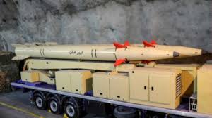
GhassemBasir Missile unveiled by Iran
- 08 May 2025
In News:
Iran has recently introduced a new solid-fuel medium-range ballistic missile (MRBM) named GhassemBasir.
About the GhassemBasir Missile
The missile is designed to engage targets at distances exceeding 1,200 kilometers, enhancing Iran’s strategic strike capabilities.
Key Features:
- Size and Weight: The missile measures approximately 11 meters in length and weighs around 7 tons.
- Advanced Materials: Its airframe is reportedly constructed using carbon fiber composite materials, which reduce structural weight and lower its radar signature.
- Warhead: The missile carries a warhead estimated to weigh about 500 kilograms.
- Propulsion: Powered by a solid-fuel system, the missile benefits from quicker launch readiness and improved storage stability compared to liquid-fuel missiles.
- Speed: Capable of reaching speeds up to Mach 12.
- Guidance System: Equipped with a thermal imaging sensor that enables the missile to detect and home in on targets by sensing heat signatures during the final flight phase.
- Maneuverable Reentry Vehicle (MaRV): The missile features a MaRV that separates from the booster, reducing aerodynamic drag, decreasing radar detectability, and enhancing ballistic performance.
- Mobility: It can be launched from mobile transporter-erector-launchers (TELs), including vehicles resembling civilian trucks, increasing its operational flexibility and survivability.
Iran’s Missile Advancements
- 04 Feb 2025
In News:
In a significant military development, Iran has successfully test-fired the Ghadr-380, an advanced anti-warship cruise missile with a range of 1,000 kilometers (600 miles).
This capability allows it to target U.S. Navy warships deployed in critical maritime regions like the Persian Gulf and the Sea of Oman. The missile test was launched from an underground missile facility and was broadcast on Iranian state television, underscoring its strategic messaging.
Key Missiles Unveiled by Iran:
1. Ghadr-380 Cruise Missile:
- Type: Anti-warship cruise missile
- Range: Over 1,000 km
- Features:
- Anti-jamming capability
- Quick-launch readiness (operable by one person in less than 5 minutes)
- Launch Details:
- Fired from an underground missile base in central Iran
- Targeted the Sea of Oman
- Specific test timing and warhead specifications were not disclosed
2. Etemad Ballistic Missile:
- Name Meaning: Etemad means "trust" in Persian
- Type: Precision-guided ballistic missile
- Range: 1,700 km (1,056 miles)
- Specifications:
- Length: 16 meters
- Diameter: 1.25 meters
- Equipped with precision-guided warhead
- Built by: Iranian Ministry of Defence
Ballistic vs. Cruise Missiles: Understanding the Distinction
Feature Ballistic Missile Cruise Missile
Propulsion Rocket-propelled at launch; unpowered descent Jet engine-powered throughout flight
Flight Path Arched trajectory (leaves and re-enters atmosphere) Straight, low-altitude flight within atmosphere
Detection Easier to track via radar once launched Difficult to detect due to low-altitude flight
Launch Platforms Ground-based, silo, mobile launchers Ground, air, or sea platforms
Warhead Capability Can carry conventional or nuclear warheads Usually conventional, but may carry nuclear in advanced forms
Iran’s Strategic Missile Doctrine
Underground Missile Facilities:
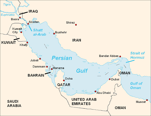
- Iran maintains extensive underground missile bases, especially in southern Iran near the Strait of Hormuz—a chokepoint for global oil trade.
- Such facilities enhance survivability and rapid response capabilities.
Missile Development Drivers:
- Iran's missile program evolved as a strategic deterrent post the Iran-Iraq War (1980–1988), where both countries used missiles to target civilian areas.
- UN arms embargoes led Iran to focus on domestic development of missile systems, including both cruise and ballistic types.
Capabilities:
- Iran now claims to possess missiles with ranges up to 2,000 kilometers, capable of reaching parts of the Middle East, including Israel.
- The Ghadr-380 and Etemad missiles are examples of technological diversification—from ballistic to precision cruise systems.
Implications for Regional and Global Security
- Deterrence Posture: Iran’s missile advancements strengthen its deterrence, especially amid strained relations with the U.S. and its allies.
- Threat to Maritime Security: The Ghadr-380, with its anti-warship focus, poses a direct threat to U.S. naval assets in the Persian Gulf and adjacent waters.
- Escalation Risks: Enhanced missile capabilities could escalate regional tensions, particularly in flashpoints like the Strait of Hormuz.
- Western Concerns: The U.S. and European nations remain wary of Iran’s dual-track approach involving missile and nuclear program developments.
Iran's Capital Relocation

- 15 Jan 2025
In News:
Iran has announced plans to relocate its capital from Tehran to the Makran coastal region due to economic and environmental concerns.
Reasons Behind Relocation
- Overcrowding and Resource Constraints: Tehran, the capital for over 200 years since the Qajar dynasty (1794-1925), faces overpopulation, air pollution, water scarcity, and energy shortages.
- Strategic Importance of Makran: Located in Sistan and Baluchestan Province, Makran’s proximity to the Gulf of Oman enhances its potential for economic development.
- Economic and Maritime Significance: Home to key ports like Chabahar, Makran is vital for Iran’s petroleum reserves and coastal trade.
- Geopolitical Considerations: The development of Makran as an international trade hub could strengthen Iran’s economic ties with Central Asia and the Indian Ocean region.
About Makran
- Geographical Overview: A semi-desert coastal plateau shared by Pakistan and Iran, bordered by the Arabian Sea and the Gulf of Oman.
- Key Ports and Trade Routes: Gwadar (Pakistan) and Chabahar (Iran) serve as critical gateways to the Strait of Hormuz, a global oil supply route.
Alexander’s Invasion and Makran’s Historical Significance
Background of Alexander’s Invasion (327–325 BCE)
- Entry into India: Alexander, King of Macedonia (336-323 BCE), entered India via the Khyber Pass after conquering Kabul.
- Key Battles:
- Battle of Hydaspes (Jhelum): Faced and defeated King Porus, later reinstating him as an ally.
- Retreat at Hyphasis (Beas River): His army, exhausted and wary of the Nanda Empire’s strength, refused to march further east.
The Gedrosian Desert March
- Extreme Hardships: While retreating through the Makran Desert, Alexander lost a third of his army to dehydration, starvation, and exhaustion.
- Comparison with Cyrus the Great: Unlike Cyrus II, who failed to cross the desert, Alexander’s army endured the harsh terrain, albeit with heavy casualties.
Impact of Alexander’s Invasion on India
- Cultural and Trade Exchanges: Facilitated early Indo-Greek interactions and opened key trade routes linking South Asia and Europe.
- Greek Settlements: Established cities like Alexandria (Kabul) and Boukephala (Jhelum), influencing local governance and trade.
- Mauryan Expansion: Weakened regional rulers enabled Chandragupta Maurya to establish the Mauryan Empire.
- Influence on Art and Culture: Indo-Greek fusion led to the Gandhara School of Art, integrating Greek and Indian artistic traditions.
Exercise SURYA KIRAN

- 28 Dec 2024
In News:
Indian Army Contingent Departs for 18th Edition of Exercise SURYA KIRAN (India-Nepal Joint Military Exercise).
Key Highlights:
- Event Overview:
- Name: 18th Edition of Battalion-Level Joint Military Exercise SURYA KIRAN.
- Dates: 31st December 2024 to 13th January 2025.
- Location: Saljhandi, Nepal.
- Participants: Indian Army (334 personnel, led by a Battalion from the 11th Gorkha Rifles) and Nepal Army (Srijung Battalion).
- Objective of Exercise:
- Enhance interoperability in jungle warfare, counter-terrorism operations in mountainous terrain, and Humanitarian Assistance and Disaster Relief (HADR) under the UN Charter.
- Focus on operational preparedness, aviation training, medical aspects, and environmental conservation.
- Key Features:
- Training Focus: Improving combat skills and coordination to operate together in challenging situations.
- Exchange of Ideas: Soldiers from both nations will share best practices, enhance mutual understanding of operational procedures.
- Strengthening Bilateral Relations: Reinforces strong bonds of friendship, cultural linkages, and defense cooperation between India and Nepal.
- Significance:
- Historical Context: Exercise held alternately in India and Nepal since 2011.
- Enhances Combat Readiness: Prepares both armies to address shared security challenges and improve operational capabilities.
- Diplomatic Engagement: Fosters a productive professional environment between India and Nepal.
- Recent Developments:
- The exercise follows visits by General Upendra Dwivedi (Indian Army Chief) to Nepal and General Ashok Raj Sigdel (Nepali Army Chief) to India, strengthening military ties.
- Previous Editions:
- 17th Edition: Conducted in Pithoragarh, Uttarakhand (24th Nov - 7th Dec 2023).
Rare Golden Tiger takes a stroll in Assam’s Kaziranga National Park, video stuns people (HT)

- 27 Jan 2024
Why is it in the News?
A rare golden tiger was recently spotted in Kaziranga National Park taking a stroll and is the only known golden big cat in India.
What is a Golden Tiger?
- A Golden Tiger, also called a Golden Tabby Tiger, is a Bengal tiger with a unique colour variation caused by a recessive gene.
- The tiger looks golden because it has a mutation or a genetic variant.
- Basically, tigers have three colours: black, orange and white.
- In the Golden Tiger, the black colour is missing and it is slightly faded.
- The golden colouring of these tigers comes from a recessive trait called 'wideband,' affecting how black pigments are produced during hair growth.
- Golden tigers are not a distinct subspecies but rather a product of genetic diversity among Bengal tigers.
- They are extremely rare in the wild and even more so in captivity.
About Kaziranga National Park:
- Kaziranga National Park lies partly in the Golaghat District and partly in the Nagaon District of Assam.
- It is the oldest park in Assam and covers an area of 430 sq km along the river Brahmaputra on the North and the Karbi Anglong hills on the South.
- The National Highway 37 passes through the park area and tea estates, hemmed by table-top tea bushes.
- Kaziranga National Park a world heritage site is famous for the Great Indian one-horned rhinoceros, the landscape of Kaziranga is of sheer forest, tall elephant grass, rugged reeds, marshes & shallow pools.
- It was declared a National Park in 1974.
- It is one of the last areas in eastern India undisturbed by a human presence.
- It is inhabited by the world's largest population of one-horned rhinoceroses, as well as many mammals, including tigers, elephants, panthers and bears, and thousands of birds.
- Vegetation: Due to the difference in altitude between the eastern and western areas of the park, mainly four main types of vegetation’ like alluvial inundated grasslands, alluvial savanna woodlands, tropical moist mixed deciduous forests, and tropical semi-evergreen forests.
- Flora: Kumbhi, Indian gooseberry, cotton tree, and elephant Apple are among the famous trees that can be seen in the park.
- Fauna: The forest region of Kaziranga Park is home to the world’s largest population of Indian Rhinoceros.
- Other animals that can be seen in the elephant grass, marshland and dense tropical moist broadleaf forests of Kaziranga are Hoolock Gibbon, Tiger, Leopard, Indian Elephant, Sloth Bear, Wild water buffalo, swamp deer, etc.
- Also in this park the good number of migratory bird species from Central Asia.
- With the increase in tiger population every year, the government authorities declared Kaziranga a Tiger Reserve in the year 2006.
Atomic watchdog report says Iran is increasing production of highly enriched uranium (Indian Express)
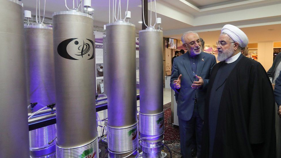
- 27 Dec 2023
Why is it in the News?
Iran has increased the rate at which it is producing near weapons-grade uranium in recent weeks, reversing a previous slowdown that started in the middle of this year, the International Atomic Energy Agency said in a report.
What is Uranium Enrichment?
- Natural uranium is comprised of two isotopes, with approximately 99% being U-238 and only about 0.7% being U-235.
- U-235 is a fissile material capable of sustaining a chain reaction within a nuclear reactor.
- The enrichment process involves increasing the proportion of U-235 through isotope separation, effectively isolating U-238 from U-235.
- For the production of nuclear weapons, enrichment is necessary up to 90% or more, referred to as weapons-grade uranium.
- Low-enriched uranium, typically containing a 3-5% concentration of U-235, is suitable for generating fuel for commercial nuclear power plants.
- In contrast, highly enriched uranium, boasting a purity of 20% or more, finds application in research reactors.
Key Facts About Uranium:
- Discovered in 1789 by the German chemist Martin Klaproth, Uranium is a silvery-white metallic chemical element found in the periodic table, characterized by its atomic number 92.
- This element holds the distinction of having the highest atomic weight among all naturally occurring elements.
- Naturally present in low concentrations in soil, rock, and water, uranium is commercially extracted from minerals like uraninite.
- The mining of uranium ore can be undertaken through open pits or underground excavations, followed by crushing and processing at a mill to isolate the valuable uranium.
- An alternative method involves the direct dissolution of uranium from ore deposits in the ground, known as in-situ leaching, with the extracted uranium then pumped to the surface.
About the International Atomic Energy Agency (IAEA):
- The International Atomic Energy Agency is an intergovernmental organization that seeks to promote the peaceful use of nuclear energy and to inhibit its use for any military purpose, including nuclear weapons.
- Established as an autonomous entity through its international treaty, the IAEA Statute, the organization, nonetheless, reports to both the United Nations General Assembly and the Security Council.
- Headquartered in Vienna, Austria, the IAEA collaborates with its Member States and various global partners to advance the safe and peaceful utilization of nuclear technologies.
- It employs nuclear safeguards, encompassing monitoring, inspection, information analysis, and other measures, to ensure the peaceful nature of nuclear activities and to detect and deter any potential diversion towards weapons-related purposes.
- The IAEA plays a crucial role in implementing comprehensive safeguards agreements mandated by the Nuclear Non-Proliferation Treaty (NPT), acting as a frontline defense against nuclear weapons proliferation.
- Additionally, the agency facilitates the exchange of scientific and technical information among its Member States.
- A key function of the IAEA is to bolster national, regional, and international capabilities to respond effectively to nuclear and radiological incidents, thereby minimizing their impact.
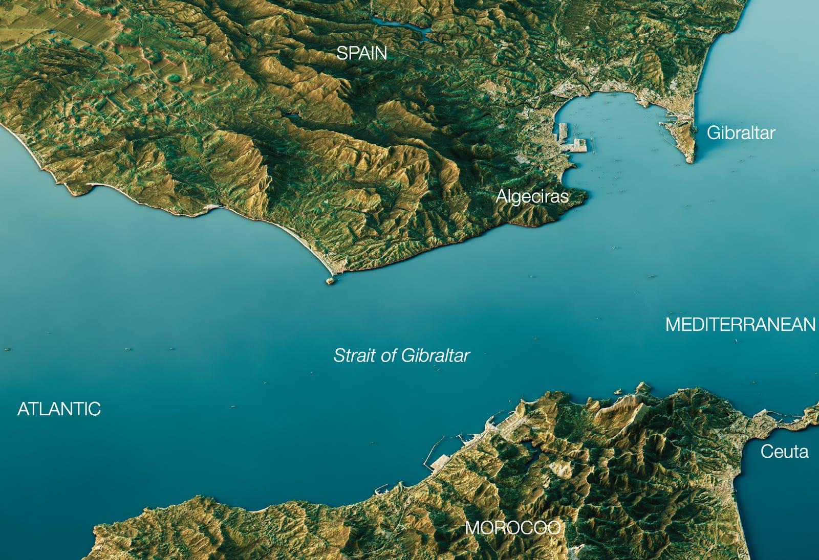
Iran has threatened to close the Strait of Gibraltar linking the Mediterranean and the Atlantic for shipping (The Hindu)
- 25 Dec 2023
Why is it in the News?
Recently, Iran has threatened to close the Strait of Gibraltar and the Mediterranean Sea unless Israel stops bombing Gaza.
About the Strait of Gibraltar:
- The Strait of Gibraltar is a narrow water passage that serves as a crucial link connecting Europe and Africa, facilitating the connection between the Mediterranean Sea and the Atlantic Ocean.
- Historical Significance: Prior to the inauguration of the Suez Canal in 1869, the Strait of Gibraltar held exclusive prominence as the sole gateway to the Mediterranean Sea.
- Geographical Borders: Positioned between Spain and the British Overseas Territory of Gibraltar in the north, and Morocco and the Spanish exclave of Ceuta in the south, the strait spans approximately 58 km and reaches a width of about 13 km at its narrowest point.
- Depth and Geological Formation: With depths ranging from 300 to 900 meters, the strait constitutes a significant divide between the elevated plateau of Spain and the Atlas Mountains of Northern Africa.
- Geological studies indicate that the strait originated from the northward movement of the African Plate towards the European Plate.
- High Maritime Activity: Recognized as one of the world's busiest waterways, the Strait of Gibraltar witnesses the daily transit of around 300 ships, equivalent to approximately one ship every 5 minutes.
- The Moroccan port of Tanger-Med, situated near Tangier, is a prominent port along the strait.
- Pillars of Heracles: Marking the eastern extremity of the strait, the area between the Rock of Gibraltar in the north and Mount Hacho or Jebel Moussa in the south spans approximately 23 km.
- These two land features referred to as the Pillars of Heracles, hold historical and geographical significance.
About the Mediterranean Sea:
- The Mediterranean Sea, an intercontinental body of water, is flanked by Europe to the north, Asia to the east, and Africa to the south.
- In the western expanse, it connects to the Atlantic Ocean through the narrow Strait of Gibraltar.
- To the extreme northeast, it links to the Black Sea via the Dardanelles Strait, the Sea of Marmara, and the Bosporus Strait.
- In the southeast, the Mediterranean Sea is connected to the Red Sea through the Suez Canal.
- Historical Significance: Recognized as the cradle of Western civilization, the Mediterranean Sea has played a pivotal role in the development of ancient cultures.
- Notable civilizations, including the Phoenicians, Ancient Greece, and the Roman Empire, flourished along its shores.
- Countries and Territories Along the Coast: A total of 22 countries, along with one territory (Gibraltar, a British Overseas Territory), have coastlines along the Mediterranean Sea.
- European nations with Mediterranean coastlines include Spain, France, Italy, Malta, Monaco, Slovenia, Croatia, Bosnia and Herzegovina, Montenegro, Albania, and Greece.
- Countries from the West Asian (Middle Eastern) region bordering the Mediterranean Sea include Turkey, Syria, Lebanon, Israel, Palestine (Gaza Strip), and the divided island of Cyprus.
- Additionally, five North African nations, namely Morocco, Algeria, Tunisia, Libya, and Egypt, have coastlines along the Mediterranean.
India-Iran drop Foreign Arbitration clause in Chabahar Port Issue (The Hindu)
- 26 Aug 2023
What is the News ?
India and Iran have agreed to pursue arbitration under rules framed by the UN Commission on International Trade Law (UNCITRAL) and will not go for commercial arbitration in foreign courts.
Facts About:
UN Commission on International Trade Law (UNCITRAL):
It is a subsidiary body of the UN General Assembly, established in 1966.
Mandate: To further the progressive harmonisation and unification of the law of international trade.
Membership:
- The Commission is composed of 60 member States elected by the General Assembly.
- The 60 member States include 14 African States, 14 Asian States, 8 Eastern European States, 10 Latin American and Caribbean States and 14 Western European and other States.
- The General Assembly elects members for terms of six years; every three years, the terms of half of the members expire.
- India is a founding member of this organisation.
Key facts about Chabahar Port
- It is a seaport in the Sistan-Balochistan province of Iran, on the Gulf of Oman, at the mouth of the Strait of Hormuz.
- It is a deep-water port with direct access to the Indian Ocean that is outside the Hormuz Strait.
- Its geographic proximity to countries such as Afghanistan, Pakistan, and India, as well as its status as a key transit centre on the burgeoning International North-South Transport Corridor.
Source: https://www.thehindu.com/news/national/india-and-iran-drop-foreign-court-arbitration-for-chabahar-port/article67234071.ece