Cyclone Ditwah and Cyclone Senyar
- 29 Nov 2025
In News:
Two tropical cyclonic systems, Cyclone Ditwah and Cyclone Senyar, developed almost simultaneously over the Bay of Bengal–Andaman Sea region, drawing attention to the heightened cyclogenesis during the retreating phase of the Southwest Monsoon (October–November). The India Meteorological Department (IMD) has issued alerts for India’s east coast due to associated heavy rainfall and wind impacts.
Cyclone Ditwah: Key Facts
- Nature: Tropical cyclonic storm
- Area of formation: Southwest Bay of Bengal
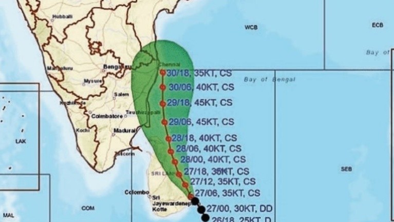
- Development: Rapid intensification from a depression to a cyclonic storm in less than 24 hours
- Movement & impact: Moving towards the coasts of Tamil Nadu, Puducherry and southern Andhra Pradesh, with heavy rainfall and gusty winds expected
- Naming: Ditwah is the recommended name by Yemen
Cyclone Senyar: Key Facts
- Nature: Cyclonic system originating from a low-pressure area
- Area of formation: Near Malaysia/Strait of Malacca, over the South Andaman Sea and adjoining Bay of Bengal
- Development: Intensified into a depression and further strengthened before weakening over the Strait of Malacca
- Impact: Though it weakened, its remnant circulation and moisture feed triggered very heavy rainfall over parts of the Andaman & Nicobar Islands and South India
- Naming: Senyar is the recommended name by the UAE
Why are cyclones frequent in the Bay of Bengal During the Retreating Monsoon?
- Warm Sea Surface Temperatures (SSTs): Post-monsoon SSTs of ~28–30°C or higher provide abundant latent heat for cyclone formation.
- High Moisture Content: Strong moisture inflow from the equatorial Indian Ocean and the Bay creates a deep, humid troposphere, favouring convection.
- Southward Shift of ITCZ: During monsoon withdrawal, the Inter-Tropical Convergence Zone (ITCZ) and monsoon trough move southward over the Bay, enhancing convergence and vorticity.
- Low Vertical Wind Shear: October–early November typically sees reduced wind shear over the Bay, allowing systems to organise and intensify.
- Re-intensification of Monsoon Lows: Remnant lows/depressions moving back over warm Bay waters can re-strengthen into cyclones.
- Bay vs Arabian Sea Contrast: The Bay’s semi-enclosed nature, large river freshwater inflows (e.g., Ganga–Brahmaputra), and warmer, stratified surface waters make it more cyclone-prone than the Arabian Sea in this season.
Regional Implications
- East Coast Vulnerability: Tamil Nadu, Puducherry and Andhra Pradesh face risks of heavy rain, flooding and wind damage.
- Island Territories: The Andaman & Nicobar Islands are particularly susceptible to rainfall bursts from systems forming near the Andaman Sea.
- Hydro-meteorological Risk: Back-to-back systems can compound impacts through soil saturation, runoff and riverine flooding.