Fujiwhara Effect
- 27 Nov 2025
In News:
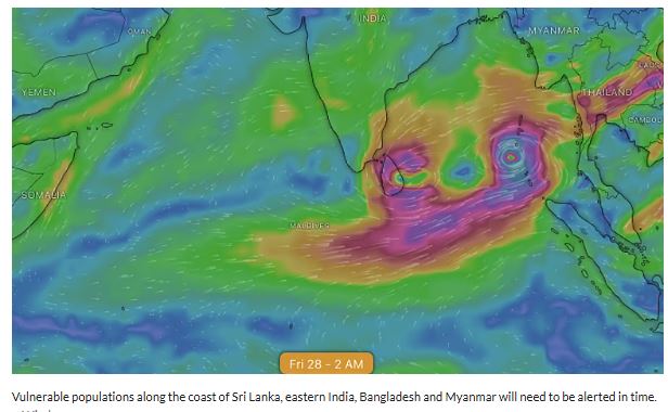
Meteorological agencies are closely monitoring the possible formation of two cyclonic systems in the Bay of Bengal, with global forecast models indicating a rare Fujiwhara-type interaction between them. Such an interaction can significantly increase uncertainty regarding cyclone track, intensity, and landfall, putting large coastal populations of South and Southeast Asia on alert.
Current Meteorological Situation
- The India Meteorological Department (IMD) has identified a well-marked low-pressure area over Malaysia and the adjoining Straits of Malacca, likely to move west-northwestwards.
- This system is expected to intensify into a depression over the South Andaman Sea, and further strengthen into a cyclonic storm over the southern Bay of Bengal within 48 hours thereafter.
- Simultaneously, an upper air cyclonic circulation over the Comorin region may induce another low-pressure area over the southwest Bay of Bengal and Sri Lanka, with potential to intensify further.
Divergence in Global Forecast Models
- Forecasts from the Global Forecast System (GFS) and the European Centre for Medium-Range Weather Forecasting (ECMWF) show significant differences in predicting the formation, interaction, track, and intensity of these systems.
- One scenario suggests the storms may interact and move together, potentially strengthening one system at the expense of the other, while another scenario shows divergent tracks, including possible movement along India’s eastern coast or towards Myanmar.
Fujiwhara Effect:
- Definition: A rare meteorological phenomenon where two nearby cyclonic systems rotate around a common centre due to interaction of their wind circulations.
- Origin: Identified by Sakuhei Fujiwhara (1921).
- Conditions Favoring Occurrence:
- Distance between cyclones usually less than ~1,400 km
- Same rotational direction (counter-clockwise in the Northern Hemisphere)
- Sea Surface Temperature >26°C
- Low vertical wind shear
Possible Outcomes of Fujiwhara Interaction
- Energy Transfer: One cyclone may intensify by drawing energy and moisture from the other.
- Merger: The two systems may fuse into a single, stronger cyclone.
- Deflection: Cyclones may push each other onto altered or diverging paths.
- Weakening: Competition for heat and moisture may weaken one or both systems.
- Stalling: Reduced movement speed can lead to prolonged rainfall over affected regions.
Implications for India and the Region
- Forecast Challenges: Track and intensity prediction becomes difficult, complicating early warning and disaster preparedness.
- Heavy Rainfall Risk: Prolonged rainfall over eastern India, Sri Lanka, Bangladesh, and Myanmar, increasing flood and landslide risk.
- Cyclone Intensification: Sudden strengthening may enhance threats from strong winds, storm surge, and coastal damage.
Fujiwhara Effect (Indian Express)
- 24 Aug 2023
What is the News ?
Recently, powerful winds tormented the Bay Area and other parts of Central and Southern California, uprooting trees and disrupting the power supply due to Fujiwhara effect.
Facts About:
- It was identified by a Japanese meteorologist Sakuhei Fujiwhara.
- It was observed for the first time over the western Pacific Ocean, when typhoons Marie and Kathy merged in 1964.
What is it?
- When two hurricanes (or cyclones, depending on where you live), spinning in the same direction, are brought close together, they begin ‘an intense dance around their common center’ – this interaction between two cyclones is called the Fujiwhara effect.
When it Occur?
- If one hurricane’s intensity overpowers the other, then the smaller one will orbit it and eventually crash into its vortex to be absorbed.
- On the other hand, if two storms of similar strengths pass by each other, they may gravitate towards each other until they reach a common center and merge, or merely spin each other around for a while before shooting off on their own paths.
- In rare instances, the two ‘dancing’ cyclones, if they are intense enough, may merge with one another, leading to the formation of a mega cyclone capable of wreaking havoc along coastlines.
Experts have noted the rising frequency of this unusual effect, attributing it to a rapidly warming world and the subsequent heating of ocean waters.
Source: https://www.google.com/url?sa=t&rct=j&q=&esrc=s&source=web&cd=&ved=2ahUKEwia1b_gj6OBAxXpSmwGHVb_DTQQFnoECBUQAQ&url=https%3A%2F%2Findianexpress.com%2Farticle%2Fexplained%2Fexplained-climate%2Ffujiwhara-effect-cyclones-dance-8905398%2F&usg=AOvVaw0_moE3dRI3IZbhz8XqmBkl&opi=89978449