Aravalli Hills
- 28 Nov 2025
In News:
The Supreme Court of India has accepted the recommendations of a Union Environment Ministry appointed committee on a uniform definition of the Aravalli Hills and Ranges, with the stated objective of restricting mining, prohibiting activity in core/inviolate areas, and enabling sustainable mining practices. The decision follows long-standing concerns over rampant legal and illegal mining in the Aravalli region.
Background
- The Aravalli Hills have faced decades of degradation due to mining and construction.
- In May 2024, the Supreme Court directed the Centre to evolve a uniform definition of the Aravallis, as the absence of clarity hindered effective regulation.
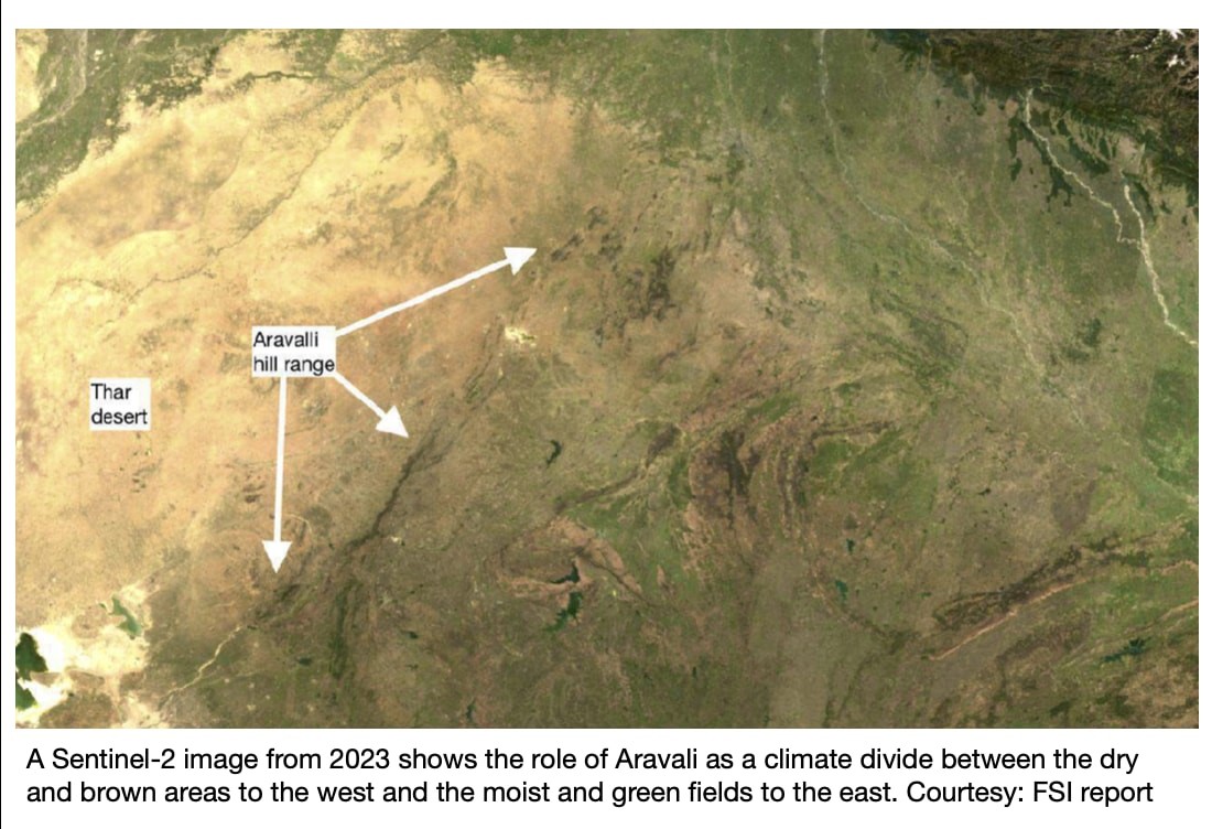
- Historically, the Forest Survey of India (FSI) used a 3-degree slope criterion (since 2010) to delineate Aravalli hills.
- A technical sub-committee (2024) later proposed identifying Aravalli hills as landforms with a minimum slope of 4.57 degrees (8%) and height of at least 30 m, which would have covered around 40% of the range.
New Definition Accepted by the Supreme Court
- Any landform with an elevation of 100 metres or more above local relief, along with its slopes and adjacent areas, will be considered part of the Aravalli Hills.
- As per internal FSI assessments:
- Only 1,048 hills (≈8.7%) out of over 12,000 hill features in Rajasthan meet the 100 m height criterion.
- Consequently, over 90% of the Aravalli landscape would fall outside the new definition.
Ecological Significance of the Aravalli Range
- The Aravalli Range stretches for about 692 km, from Gujarat to Delhi, via Rajasthan and Haryana; Rajasthan accounts for nearly two-thirds of its extent.
- It is the oldest mountain range in India and plays a vital role in:
- Acting as a barrier against desertification from the Thar Desert
- Regulating regional climate and air quality, especially in Delhi–NCR
- Serving as a watershed for rivers like Luni, Banas and Sabarmati
- Supporting biodiversity and wildlife corridors (e.g., Sariska–Ranthambhore)
Key Concerns with the New Definition
- Environmental impact: FSI cautioned that even low hills (10–30 m) function as crucial wind and dust barriers; their exclusion could worsen sand and dust transport toward the Indo-Gangetic plains and NCR.
- Methodological issues:
- Use of district-average slope and elevation masks the presence of local hill features.
- Comparing height above mean sea level with height above local relief leads to potential misclassification.
- Area exclusion: Several districts with known Aravalli features (e.g., Chittorgarh, Sawai Madhopur) were left out of the ministry’s Aravalli district list.
Way Forward
- While accepting the 100-m height definition, the Supreme Court has directed the Environment Ministry to prepare a Management Plan for Sustainable Mining, with technical support from the Indian Council of Forestry Research and Education (ICFRE).
- The plan aims to:
- Prevent illegal mining
- Regulate permitted mining sustainably
- Protect core/inviolate zones of the Aravalli ecosystem