India’s Updated Seismic Zonation Map (2025)
- 28 Nov 2025
In News:
India has released an updated Seismic Zonation Map (2025) under the revised Earthquake Design Code (IS 1893), marking a major shift in the country’s approach to earthquake risk assessment and structural safety. The revision replaces the 2016 map and aligns India’s standards with contemporary scientific understanding and international best practices.
Why Was the Update Needed?
- Underestimation of Himalayan Risk: Earlier maps classified the Himalaya largely under Zones IV and V, despite the region being among the most tectonically active belts globally along the Indian–Eurasian plate boundary.
- Outdated Methodology: Previous zonation relied heavily on historical epicentres, past damage, and broad geology, overlooking evolving rupture dynamics.
- Rupture Propagation Ignored: Southward propagation of Himalayan Frontal Thrust ruptures was inadequately captured, underestimating risks in densely populated foothill towns such as Dehradun.
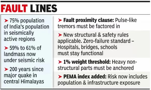
- Rising Exposure: Nearly three-fourths of India’s population now lives in seismically active regions, increasing disaster vulnerability.
- Global Practice Gap: The need to adopt Probabilistic Seismic Hazard Assessment (PSHA), used internationally, became imperative.
What is a Seismic Zonation Map?
A seismic zonation map divides a country into zones based on the expected intensity and frequency of earthquakes.
- Issued by the Bureau of Indian Standards (BIS)
- Integrated into IS 1893 (Earthquake Design Code)
- Forms the basis for urban planning, infrastructure design, and disaster preparedness
Key Features of the Seismic Zonation Map 2025
- Introduction of Zone VI:
- A new highest-risk zone created.
- The entire Himalayan arc from Jammu & Kashmir–Ladakh to Arunachal Pradesh, now falls under Zone VI, reflecting sustained extreme tectonic stress.
- Scientific Basis – PSHA:
- Uses Probabilistic Seismic Hazard Assessment, factoring in:
- Ground-shaking attenuation with distance
- Tectonic regime and fault behaviour
- Underlying lithology
- Uses Probabilistic Seismic Hazard Assessment, factoring in:
- Expanded High-Risk Coverage:
- 61% of India’s landmass now lies in moderate to high hazard zones (up from 59%).
- The Peninsular Plateau shows minor refinements, retaining a relatively stable seismic profile.
- Boundary Rule Enhancement: Towns located along zone boundaries will be assigned to the higher-risk zone.
- Focus on Non-Structural Safety: First-time emphasis on parapets, ceilings, overhead tanks, façade panels, lifts, electrical lines, and suspended fixtures.
- Near-Fault Provisions:
- Mandatory consideration of pulse-like ground motions near active faults.
- Updated limits on displacement, ductility, and energy dissipation.
- Site-Specific Requirements: New norms for liquefaction risk, soil flexibility, and response spectra.
- Critical Infrastructure Standards: Hospitals, schools, bridges, pipelines, and public utilities must remain functional after major earthquakes.
Implementation Challenges
- Retrofitting Existing Infrastructure: High costs, technical complexity, and coordination issues.
- Economic Impact: Stricter norms may increase construction costs.
- Technical Capacity: PSHA-based, site-specific designs require advanced geotechnical expertise and equipment.