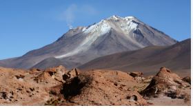
Uturuncu Volcano
- 18 Nov 2025
In News:
A recent scientific study has provided deeper insights into the unusual activity of the Uturuncu Volcano in southwestern Bolivia. Although its surface shows persistent uplift and subsidence, new seismic imaging confirms that these motions are driven by hot fluids and gases moving beneath the crater rather than rising magma, indicating a low likelihood of imminent eruption. This has earned Uturuncu the nickname of a “zombie volcano”appearing restless but not actually preparing to erupt.
Location and Geological Profile
- Country: Bolivia
- Region: Southwestern Andes Mountains
- Type:Stratovolcano, dominated by dacitic lava domes and flows
- Elevation: Approx. 6,008 m (19,711 ft) tallest mountain in southern Bolivia
- Eruption History: Last erupted ~250,000 years ago
- Current Activity: Hundreds of small earthquakes annually and persistent ground deformation
Underlying Magma and Fluid System
- Uturuncu sits above the Altiplano-Puna Magma Body (APMB), a massive crustal reservoir located 10–20 km below the surface.
- APMB spans nearly 200 km, making it the largest known active magma body in Earth’s crust.
- Seismic imaging indicates ~25% partial melt in places, acting as a deep heat and fluid source for Uturuncu.
The “Sombrero” Uplift Pattern
The volcano displays a unique deformation pattern where:
- The center uplifts, while
- The surrounding region subsides,creating a “sombrero-like” shape over a 70–93 km area.
This deformation is gradual-about 0.4 inches per year-and has persisted for at least five decades, monitored through GPS, satellite radar, and leveling surveys.
Key Findings from the Recent Study
The latest imagingusing data from over 1,700 small earthquakesreveals:
1. Fluid Movement, Not Magma Rise
- Hot supercritical fluids (with both liquid and gas characteristics) rise through a narrow conduit.
- They accumulate beneath the crater, while brines seep outward through fractured rock.
- This fluid distribution explains why the summit uplifts and the edges sink.
2. Seismic Tomography Techniques Used
Researchers used:
- Vp/Vs ratios (compressional vs. shear wave speeds) — high sensitivity to fluids
- Azimuthal anisotropy — identifying crack alignments and fluid pathways
- Low resistivity zones — tracing conductive, hot, salty fluids
These tools revealed a vertical fluid conduit feeding a shallow reservoir under the summit.
3. Eruption Risk Assessment
- No evidence of a shallow, melt-rich magma chamber
- Low gas saturation in the shallow system
- Deformation driven mostly by fluids, not magma
Thus, probability of eruption is currently low despite ongoing seismicity.
Why Uturuncu Matters
Understanding Uturuncu helps refine risk assessments for “restless” volcanoes worldwide that show signs of deformation but lack eruptible magma. This is crucial for communities near:
- Remote Andean mining regions
- Settlements along the Altiplano Plateau
- Other global volcanoes with similar gas-driven unrest
The study aids hazard planning without unnecessary alarm, preventing misinterpretation of harmless gas plumes or small quakes as eruption warnings.