Doppler Weather Radar (DWR)
- 22 Dec 2025
In News:
The Government of India has informed Parliament that 47 Doppler Weather Radars (DWRs) are currently operational across the country, covering nearly 87% of India’s geographical area. These radars play a crucial role in monitoring weather systems and improving forecasts of extreme weather events, significantly strengthening India’s disaster preparedness and early warning capabilities.
What is a Doppler Weather Radar?
A Doppler Weather Radar is an advanced meteorological instrument that uses the Doppler effect—identified by Christian Doppler—to determine both the position and velocity of atmospheric targets such as raindrops, snowflakes, or hailstones. The Doppler effect explains how the frequency of a wave changes relative to the motion of the source or observer (similar to the changing pitch of a passing train whistle).
Unlike conventional radars that only detect the location of precipitation, DWRs can also measure movement, enabling more accurate tracking of storms and cloud systems.
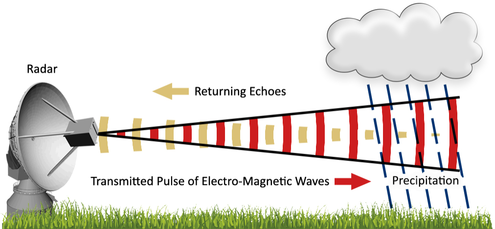
How Doppler Weather Radars Work
- The radar emits pulses of radio waves from an antenna.
- When these waves strike atmospheric particles, a portion of the energy is scattered back to the radar.
- The time taken for the signal to return helps calculate the distance of precipitation.
- The change in frequency or phase of the returned signal (Doppler shift) reveals the speed and direction of movement of weather systems.
- Larger particles reflect more energy, allowing estimation of rainfall intensity.
Radar Bands Used in India
The India Meteorological Department (IMD) employs different radar frequency bands based on application:
- S-band: Long-range surveillance and cyclone monitoring
- C-band: Widely used for cyclone tracking and regional weather observation
- X-band: Short-range, high-resolution detection of thunderstorms and lightning
Applications of Doppler Weather Radars
- Detection of precipitation: Rain, snow, hail
- Tracking movement of clouds and storms
- Estimation of rainfall intensity and distribution
- Nowcasting: Short-term forecasts of extreme events like cloudbursts, thunderstorms, squalls, and cyclones
- Coverage: Each radar can monitor weather within a radius of about 500 km