Draft Andaman and Nicobar Islands Tribal Councils Election Rules 2026
- 17 Jun 2026
In News:
The Andaman and Nicobar Islands Administration has released the Draft Andaman and Nicobar Islands Tribal Councils (Preparation of Electoral Rolls and Conduct of Elections) Rules, 2026, proposing a formal electoral framework for the Nicobarese Tribal Councils. The proposal has generated opposition among the Nicobarese community, which fears that it could undermine their customary system of self-governance.
Who are the Nicobarese?
The Nicobarese are a Scheduled Tribe (ST) inhabiting the Nicobar group of islands, with a population of around 30,000. They are represented through seven Tribal Councils, including those of Car Nicobar, Nancowry, Kamorta, Teressa, Little Nicobar, and Great Nicobar. Their traditional governance is rooted in the Tuhet (extended kinship group) system and community consensus.
Key Provisions of the Draft Rules
The draft seeks to institutionalise a formal electoral system for Tribal Councils by:
- Prescribing a fixed five-year tenure for Village and Island Tribal Councils.
- Introducing electoral constituencies, electoral rolls, and formal procedures for nomination, scrutiny and withdrawal of candidates.
- Providing for the election of 5–9 Village Captains, direct election of the Chief Captain, while First Captains elect the Vice-Chief Captain.
- Reserving seats and leadership positions for women in Village and Island Tribal Councils.
- Retaining the administrative veto under the Nicobar Islands Tribal Council Regulation, 2009, enabling the Deputy Commissioner/Assistant Commissioner to invalidate council decisions considered prejudicial to public order or peace.
Traditional Nicobarese Governance
The Nicobarese follow a consensus-based governance model rather than periodic electoral competition.
- Every village is governed by a Village Council headed by a First Captain, assisted by a Second and Third Captain, generally chosen through community consensus or secret ballot whenever required.
- The Island Tribal Council comprises the First Captains of constituent villages, who elect the Chief Captain and Vice-Chief Captain.
- Leadership is based on community acceptance, merit, education, administrative ability, and trust rather than fixed electoral cycles.
- The captaincy system dates back to the 16th century and was later formalised by the British in the late nineteenth century.
- Tribal Councils received statutory recognition through the Andaman and Nicobar Islands (Protection of Aboriginal Tribes) Regulation, 1956 and the Nicobar Islands Tribal Council Regulation, 2009.
Concerns
The Nicobarese Tribal Councils argue that the proposed reforms may:
- Weaken the traditional Tuhet-based consensus system.
- Increase bureaucratic control over indigenous self-governance.
- Dilute the authority of customary institutions through formal electoral procedures.
- Strengthen administrative oversight because of the existing veto powers under the 2009 Regulation.
- Be linked to the proposed Great Nicobar Development Project, potentially reducing institutional resistance to large-scale development projects.
- Create legal concerns since the Andaman and Nicobar Islands, being a Union Territory, lie outside the Fifth Schedule, limiting constitutional safeguards available to tribal self-governance.
Way Forward
Electoral reforms should balance constitutional values of transparency, accountability and gender inclusion with the preservation of indigenous governance traditions. Institutional changes should be undertaken through Free, Prior and Informed Consent (FPIC) and extensive consultation with Tribal Councils. A hybrid governance model, drawing inspiration from the Panchayats (Extension to Scheduled Areas) Act, 1996 (PESA), could strengthen democratic accountability while preserving the Tuhet-based customary governance system and ensuring that governance reforms remain independent of developmental or strategic projects.
Andaman & Nicobar Islands Set Guinness World Records
- 09 May 2026
In News:
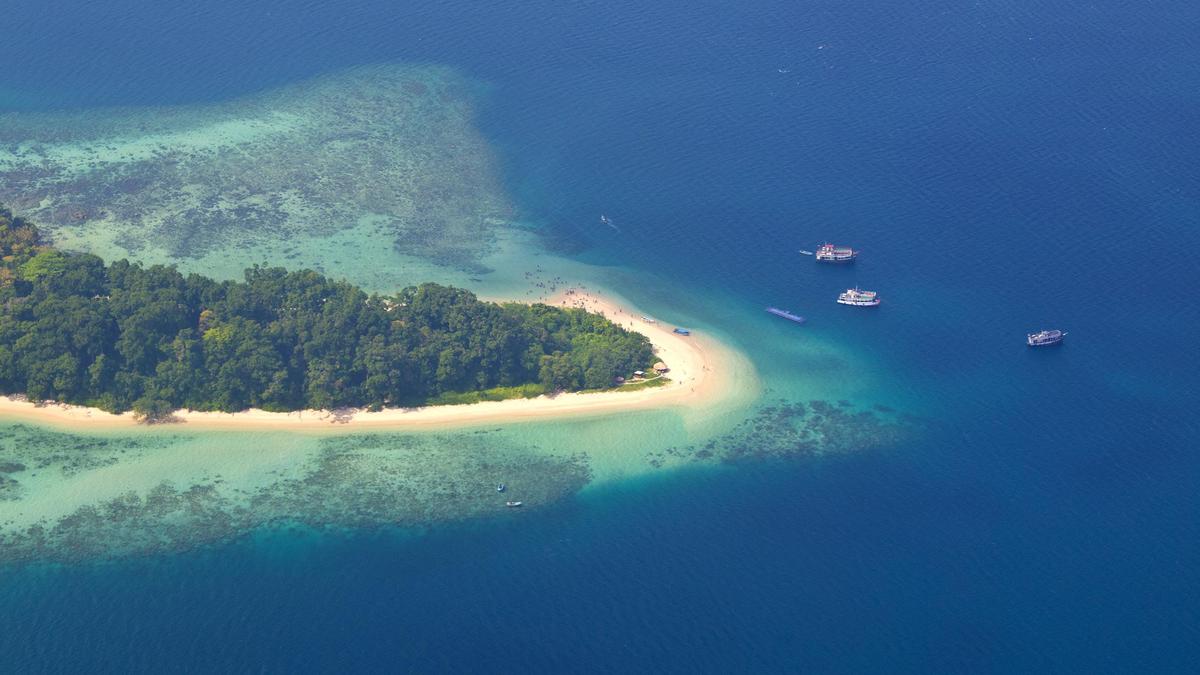
The Andaman and Nicobar Islands have recently garnered global attention by securing two Guinness World Records in the span of just two days. These feats, centered around Swaraj Dweep (formerly Havelock Island), are part of a broader strategy to position the archipelago as a premier global hub for adventure and eco-tourism.
Record-Breaking Feats at Swaraj Dweep
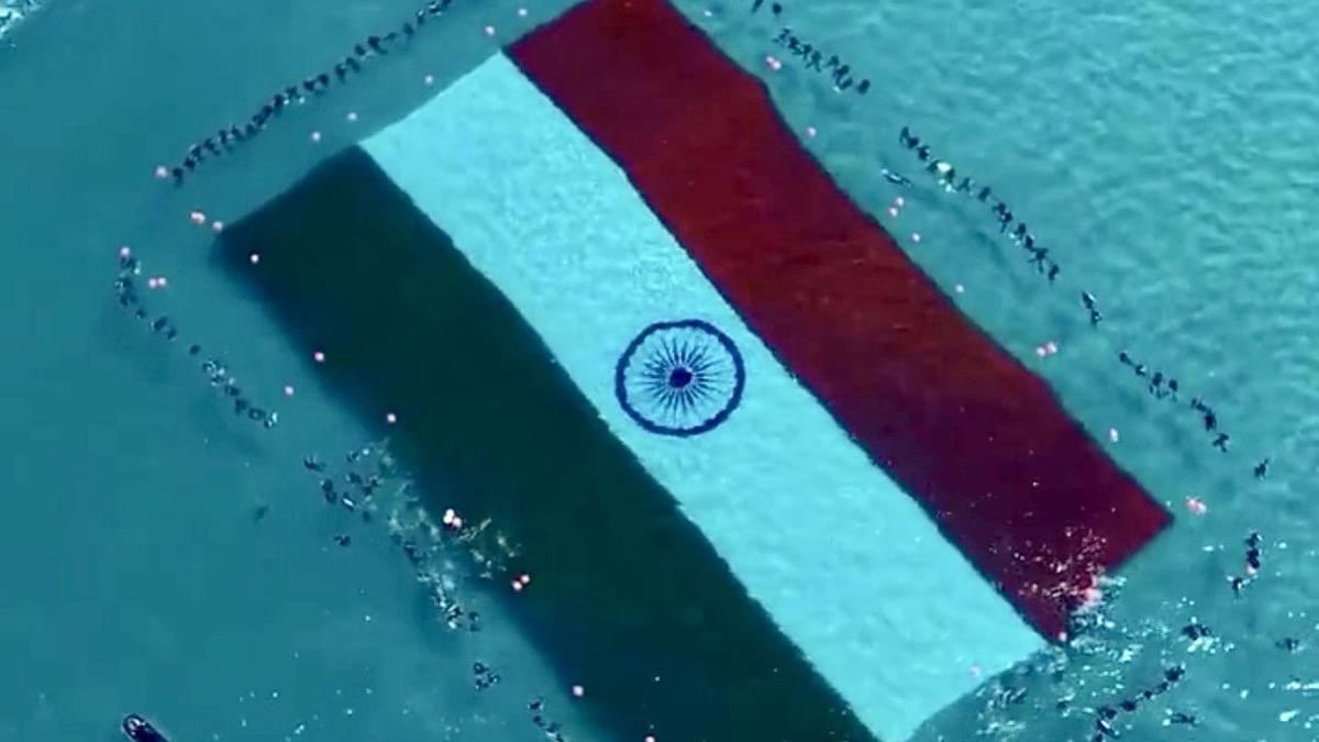
The islands hosted two unprecedented underwater events designed to showcase the region's pristine marine environment:
- Largest Flag Unfurled Underwater: Near the world-renowned Radha Nagar Beach, divers successfully unfurled a massive Indian national flag measuring 60 meters by 40 meters.
- Tallest Human Stack Underwater: In the lighthouse area of the islands, a team of divers achieved a 10-meter-high human stack, setting a new benchmark for underwater coordination and skill.
These events hold particular significance for Swaraj Dweep. Renamed in 2018 to honor India’s independence struggle, the island is a vital part of the Ritchie’s Archipelago and serves as the face of the territory’s tourism industry.
Geographic and Administrative Profile
The Andaman and Nicobar Islands are a strategically vital Union Territory comprising 836 islands, islets, and rocks situated in the Bay of Bengal. With Port Blair as the capital, the archipelago is geographically divided into two primary groups:
- The Ten Degree Channel: Following the 10° North latitude, this maritime passage separates the Andaman group in the north from the Nicobar group in the south.
- Great Nicobar: This is the largest island in the Nicobar cluster, spanning approximately 910 sq. km.
- Indira Point: Located on Great Nicobar, this landmark represents the southernmost point of India.
Ecological Wealth and Indigenous Heritage
The region is one of India’s most significant biodiversity hotspots. It is characterized by dense tropical rainforests, extensive mangrove ecosystems, and vibrant coral reefs. This environment supports a high degree of endemism in both flora and fauna.
Equally critical is the human geography of the islands. The archipelago is the ancestral home of five Particularly Vulnerable Tribal Groups (PVTGs):
- The Great Andamanese
- The Jarwa
- The Onge
- The Shompen
- The Sentinelese (noted for their continued isolation)
The preservation of these tribes and their habitats remains a cornerstone of the islands’ administrative and environmental policies.
Strategic and Geopolitical Importance
Beyond tourism and ecology, the Andaman and Nicobar Islands are central to India’s maritime security and its "Act East" Policy.
- Maritime Chokepoints: The islands sit in close proximity to the Strait of Malacca, one of the world’s most critical and busiest maritime trade routes. This location allows India to monitor vital Sea Lines of Communication (SLOCs).
- Military Significance: The archipelago hosts the country's only integrated tri-service command (the Andaman and Nicobar Command), where the Army, Navy, and Air Force operate under a single operational commander. This unique setup enhances India’s rapid response capabilities in the Indian Ocean Region (IOR).
Andaman Sea
- 16 Apr 2026
In News:
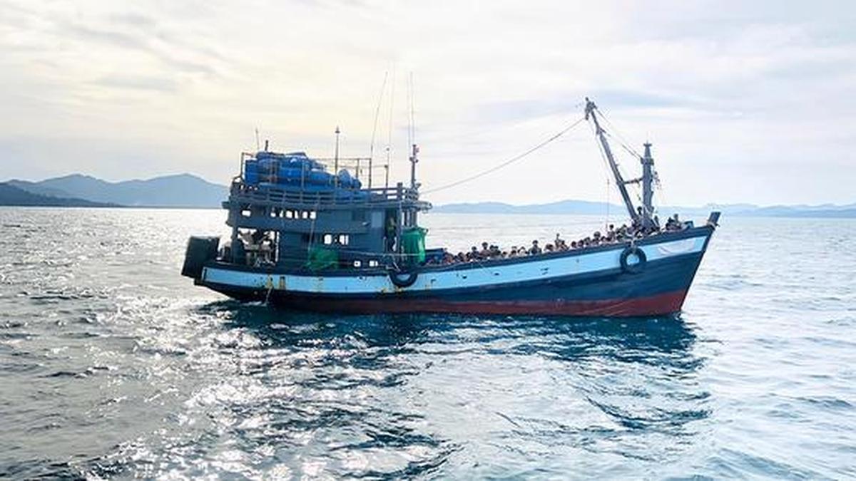
The Andaman Sea has recently witnessed one of the deadliest maritime disasters in recent years. Recently, an overcrowded trawler carrying approximately 250 individualscomprising Rohingya refugees and Bangladeshi nationalscapsized while en route to Malaysia. This incident, reported by the UNHCR and the International Organization for Migration (IOM), underscores the growing desperation of displaced communities and the complex humanitarian challenges in South and Southeast Asia.
I. Geography and Ecology of the Andaman Sea
- Location & Boundaries: It is a semi-enclosed marginal sea in the northeastern Indian Ocean.
- West: Bounded by the Andaman and Nicobar Islands (India) and the Bay of Bengal.
- East: Bordered by the Malay Peninsula and the Strait of Malacca.
- North: Bordered by the Irrawaddy Delta of Myanmar.
- South: Bordered by the Indonesian island of Sumatra.
- Geological Significance: The region is tectonically active, situated on the Sunda Plate. It is bordered by the Indian Plate to the northwest and the Australian Plate to the southeast, making it prone to underwater seismic activity.
- Climate: Dominated by a tropical monsoon climate. The Southwest Monsoon (May–September) and Northeast Monsoon (November–February) dictate maritime safety; the recent capsize was attributed to strong winds and rough seas typical of seasonal transitions.
- Biodiversity: The sea is a global biodiversity hotspot featuring extensive coral reefs, seagrass meadows, and mangrove forests, which serve as critical habitats for diverse marine life.
II. The Humanitarian Crisis: Context and Causes
The recent tragedy is not an isolated event but a symptom of a protracted humanitarian crisis involving the Rohingya—a stateless Indo-Aryan ethnic group from Myanmar’s Rakhine State.
- Push Factors from Bangladesh:
- Overcrowded Camps: Over one million Rohingya live in the Cox’s Bazar district (Teknaf).
- Socio-Economic Restrictions: Limited access to formal education, restricted movement, and lack of employment opportunities in the camps drive desperation.
- Security Concerns: Rising violence within refugee camps and dwindling international humanitarian aid (funding cuts) have made life unsustainable for many.
- Pull Factors and Human Trafficking:
- False Promises: Human traffickers lure vulnerable individuals with promises of high-paying jobs in Malaysia or Indonesia.
- Regional Instability: Ongoing conflict in Myanmar’s Rakhine State makes the "safe, voluntary, and dignified" return of refugees nearly impossible in the current geopolitical climate.
- The Perilous Journey:
- Refugees use "rickety" and overcrowded fishing trawlers to cross the Andaman Sea.
- Statistically: 2025 was recorded as one of the deadliest years for sea crossings, with nearly 900 deaths. In 2026, fatalities in the Andaman Sea and Bay of Bengal have reportedly increased by over 40% compared to previous years.
III. Strategic and Legal Dimensions
- The "Search and Rescue" Gap: In the recent incident, the Bangladesh Coast Guard rescued nine survivors from the M.T. Meghna Pride (a Bangladesh-flagged vessel), but official search operations were limited as the capsize occurred outside Bangladesh's territorial waters. This highlights the need for a regional maritime SAR (Search and Rescue) framework.
- International Obligations: While many regional countries are not signatories to the 1951 Refugee Convention, the principle of Non-Refoulement (not returning refugees to a place where they face persecution) and the UN Convention on the Law of the Sea (UNCLOS) mandate assistance to those in distress at sea.
- Human Trafficking Prevention: The survivors were handed over to the police in Teknaf, and cases were filed under the Human Trafficking Prevention Act, emphasizing the criminal dimension of these migrations.