Asia-Pacific Economic Outlook 2026

- 23 Apr 2026
In News:
The recently released "Economic and Social Survey of Asia and the Pacific 2026" by the United Nations Economic and Social Commission for Asia and the Pacific (UN ESCAP) paints a challenging picture for the region. As the Asia-Pacific continues to be the world's fastest-growing developing bloc, its resilience is currently being tested by heightened geopolitical tensions in West Asia, leading to a sharp reversal in price stability.
Key Projections: Growth Slowdown and Inflation Spike
The report highlights a significant shift in the regional economic landscape for 2026:
- Regional Inflation Surge: Average inflation in developing economies of the Asia-Pacific is projected to climb to 4.6% in 2026, a steep rise from 3.5% in 2025.
- Economic Growth Deceleration: Correspondingly, real GDP growth is expected to slow to 4.0%, down from 4.6% in the previous year.
- The "West Asia Conflict" Catalyst: The primary driver of this volatility is the conflict in West Asia, which has disrupted energy markets and global trade routes.
- Brent Crude: Spiked to approximately $120 per barrel (a 45% increase from pre-conflict levels).
- Global Gas & Fertilizers: Natural gas prices surged by 55%, while urea prices jumped by 35%, directly inflating agricultural input costs.
Impact on the Indian Economy
India, sourcing roughly 50% of its oil and a vast majority of its LPG from West Asia, remains particularly vulnerable to these external shocks.
- GDP & Inflation Forecast: India’s growth is projected to ease to 6.4% in 2026 (from 7.4% in 2025), while domestic inflation (CPI) is expected to spike to 4.4%.
- The CAD-Oil Nexus: Historically, every $10 increase in crude oil prices widens India’s Current Account Deficit (CAD) by approximately 0.55% of GDP.
- Monetary Policy Strains: Rising "Imported Inflation" complicates the Reserve Bank of India's (RBI) mandate. High price levels limit the RBI’s ability to lower interest rates, thereby keeping borrowing costs high and potentially suppressing domestic investment.
About UN ESCAP: The Institutional Framework
Established in 1947 and headquartered in Bangkok, Thailand, UN ESCAP serves as the most inclusive intergovernmental platform for the Asia-Pacific region.
- Mandate: To promote economic and social development through regional cooperation. It is one of the five regional commissions of the United Nations.
- Membership: Comprises 53 member states and 9 associate members, focusing on solutions for sustainable development challenges.
- Core Areas of Work: UN ESCAP provides critical analytical insights into Macroeconomic Policy, Poverty Reduction, Trade, Environment, and Disaster Risk Reduction.
Challenges: "Greenflation" and Vulnerable Populations
The report introduces the concept of "Greenflation"—the rising cost of materials and energy associated with the clean energy transition. While the transition is necessary for long-term climate goals, poorly managed shifts can fuel inflation and widen income inequality.
Furthermore, these macroeconomic shocks disproportionately affect low-income households and informal workers. For the nearly 20% to 28% of the undernourished population in some regional economies, food inflation becomes a direct threat to survival as they spend a larger share of their income on basic essentials.
Policy Recommendations
To navigate this period of "polycrisis," UN ESCAP and economic experts suggest a strategic pivot:
- Strategic Reserves: For India, expediting the expansion of Strategic Petroleum Reserves (SPR) at sites like Chandikhol and Padur is crucial to buffer against sudden supply disruptions.
- Domestic Demand Pivot: Moving away from a fragile export-led growth model toward strengthening domestic and regional demand to bypass fragmented global supply chains.
- Fiscal Prudence: Adhering to fiscal discipline (as per FRBM Act guidelines) during stable periods to create the "fiscal space" necessary to respond to external shocks without spiraling into debt.
- Targeted Support: Replacing broad-based subsidies with temporary, targeted support for vulnerable households and viable firms.
Shekha Jheel Bird Sanctuary

- 23 Apr 2026
In News:
In a significant milestone for India’s conservation efforts, the Shekha Jheel Bird Sanctuary in Aligarh, Uttar Pradesh, has been designated as a Ramsar Site. This addition brings India’s total tally of "Wetlands of International Importance" to 99, reinforcing the nation's leadership in biodiversity preservation under the Ramsar Convention.
Geographic and Historical Context
Shekha Jheel is a quintessential example of a monsoonal wetland nestled within the fertile Gangetic Plains of Uttar Pradesh. Unlike many natural oxbow lakes in the region, Shekha Jheel has a unique anthropogenic origin.
- Origin: The lake emerged as a perennial freshwater body following the construction of the Upper Ganges Canal in 1852. The canal flows adjacent to the lake, maintaining its water levels throughout the year.
- Location: It is situated in the Aligarh district, serving as a critical aquatic ecosystem in an otherwise semi-arid and agricultural landscape.
Ecological Profile: Flora and Fauna
The sanctuary's ecosystem is characterized by diverse strata of vegetation that support a complex food web:
1. Diverse Vegetation
The wetland hosts a variety of aquatic flora, categorized by their growth patterns:
- Submerged Species: The depths are populated by Hydrilla verticillata, Ceratophyllum demersum, and Vallisneria spiralis.
- Floating Species: The surface is covered by free-floating plants like Salvinia, Azolla, and the invasive Eichhornia crassipes (Water Hyacinth), alongside rooted floating plants such as Nymphoides cristata.
2. Avian Diversity and the Central Asian Flyway
Shekha Jheel serves as a vital "refueling station" on the Central Asian Flyway (CAF). During the winter months, the lake transforms into a bustling habitat for thousands of long-distance migratory birds.
- Key Migrants: The sanctuary provides refuge to the Bar-headed Goose (known for flying over the Himalayas), the Painted Stork, and numerous species of migratory ducks.
- Ecosystem Services: Beyond providing a habitat, the lake aids in groundwater recharge for the surrounding agricultural belt and acts as a natural buffer for flood control.
The Ramsar Framework in India
The designation of Shekha Jheel under the Ramsar Convention (1971) signifies that the site meets rigorous international criteria for biodiversity conservation.
- India’s Standing: With 99 sites spread across 28 states and Union Territories, India has the largest network of Ramsar sites in South Asia.
- Criteria for Selection: To be listed, a wetland must support vulnerable or endangered species, provide habitat for at least 20,000 waterbirds, or play a significant role in the biological diversity of its specific region.
- Conservation Status: Ramsar status mandates the "wise use" of the wetland, encouraging sustainable management that balances human needs (like local fishing) with ecological integrity.
Prajna System

- 23 Apr 2026
In News:
In a major boost to India’s technological self-reliance in the defense sector, the Union Ministry of Home Affairs (MHA) has officially integrated 'Prajna', an indigenously developed AI-enabled satellite imaging system.
Developed by the Centre for Artificial Intelligence and Robotics (CAIR), a premier laboratory under the Defence Research and Development Organisation (DRDO), the system is set to redefine how security agencies monitor and respond to internal threats.
Overview of the Prajna System
Prajna is a state-of-the-art surveillance and decision-support platform that bridges the gap between raw satellite data and actionable intelligence. Unlike traditional systems that rely on manual interpretation of images, Prajna utilizes Artificial Intelligence (AI) to process information at high speeds, providing real-time support to decision-makers.
Key Features and Capabilities:
- AI-Driven Analytics: The core of the system lies in its ability to process vast volumes of high-resolution satellite imagery. It employs deep learning algorithms to identify specific patterns, detect changes in terrain, and flag anomalies that might be invisible to the human eye.
- Real-Time Decision Support: By automating data processing, Prajna significantly reduces the "sensor-to-shooter" or "data-to-decision" time, allowing security forces to respond to emerging situations with greater accuracy.
- Situational Awareness: The system provides a comprehensive "common operating picture" by integrating various data streams, which is vital during complex operations in varied topographical conditions.
Strategic Applications in Internal Security
The induction of the Prajna system into the MHA’s toolkit marks a shift toward proactive rather than reactive security management:
- Counter-Terrorism Operations: The system is designed to monitor sensitive regions, including border areas and dense forest tracts used as hideouts. By identifying illegal movements or suspicious infrastructure, it aids in planning precise counter-terror strikes.
- Border Management: Prajna facilitates the surveillance of India’s vast and porous borders, helping to detect infiltration attempts and the movement of contraband in real time.
- Critical Infrastructure Protection: The system monitors key installations, such as dams, power plants, and communication hubs, for any signs of sabotage or unauthorized encroaching.
- Disaster Management: While primarily a security tool, its real-time imaging capabilities can be repurposed for disaster response, such as monitoring flood levels or landslide-prone areas to coordinate rescue efforts.
Super El Niño
- 23 Apr 2026
In News:
Climate experts are sounding alarms over a potential "Super El Niño" developing in the 2026-27 cycle. With projections suggesting it could be the strongest in 140 years, this climate phenomenon is poised to redefine global temperature benchmarks in 2027 and trigger severe socio-economic disruptions.
Decoding the ENSO Mechanism
The El Niño-Southern Oscillation (ENSO) is a periodic fluctuation in sea surface temperatures (SST) and atmospheric pressure across the tropical Pacific Ocean. It consists of three phases: El Niño (warm), La Niña (cool), and Neutral.
Normal vs. El Niño Conditions
- Normal (Neutral) Phase: Strong trade winds blow from east to west (Easterlies), piling up warm surface water near Asia and Indonesia. This allows cold, nutrient-rich water to rise (upwelling) along the South American coast (Peru).
- El Niño Phase: Trade winds weaken or reverse into Westerly Wind Bursts. This allows the warm water pool to slide eastward toward the Americas as a Kelvin wave. This warm layer pushes down the thermocline (the transition layer between warm surface and cold deep water), shutting off the upwelling of cold water.
What Makes it a "Super" El Niño?
While a standard El Niño involves an SST anomaly of 0.5°C, a Super El Niño is defined by an extreme spike in the Niño 3.4 region (the central-eastern equatorial Pacific).
- Intensity Threshold: SST anomalies must soar at least 2.0°C (3.6°F) above the long-term average.
- Subsurface Heat Reservoir: A massive buildup of subsurface heat—currently measured at 7-8°C above average in localized areas—acts as high-octane fuel for surface warming.
- Westerly Wind Bursts: Unusually strong wind bursts from the west prevent the system from neutralizing, accelerating the eastward migration of heat.
- Global Warming Synergy: Human-induced climate change has raised the "baseline" temperature of the Pacific. Consequently, modern El Niños are "supercharged," starting from a warmer foundation and reaching unprecedented peaks.
Global and Regional Implications
The atmospheric response to such extreme ocean warming alters global jet streams, creating a "domino effect" of weather disasters.
1. Global Consequences
- Record Temperatures: 2027 is projected to become the hottest year on record, potentially pushing global warming past the 1.5°C threshold temporarily.
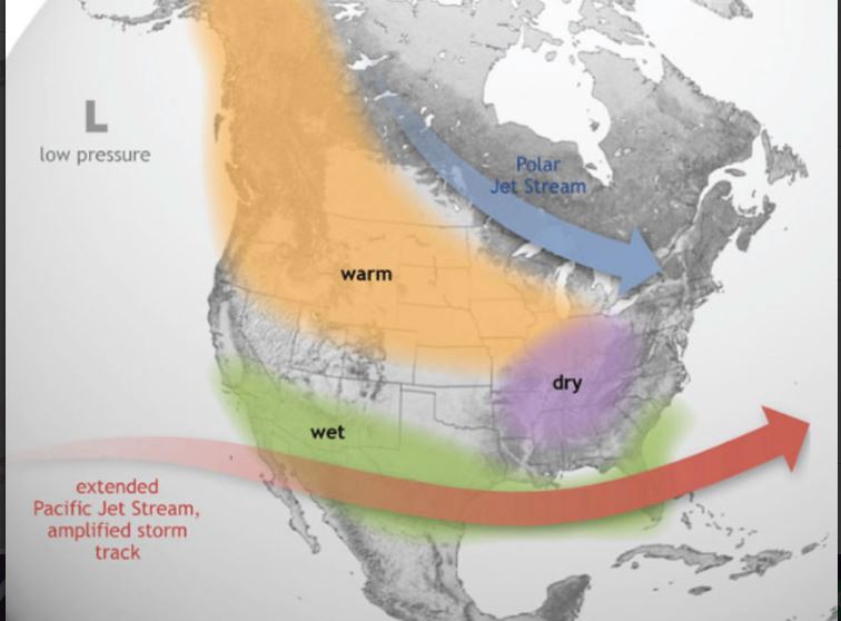
- Hydrological Extremes: While the southern US and Peru face devastating floods and deluges, regions like Ethiopia, Central Africa, and Australia are likely to endure severe, multi-year droughts.
- Hurricane Dynamics: High-altitude winds (wind shear) in the Atlantic tend to "shred" developing hurricanes, leading to a quieter Atlantic season but a more active and vicious season in the Central and Eastern Pacific.
2. The "India Factor": Monsoon and Economy
For India, a Super El Niño is traditionally a harbinger of distress:
- Monsoon Failure: There is a strong correlation between El Niño and deficient Southwest Monsoon rainfall. A "Super" event could lead to widespread drought across the subcontinent.
- Agricultural Stress: Deficient rains during the Kharif season (rice, pulses, sugarcane) can lead to crop failure, triggering food inflation and a decline in rural demand.
- Heatwaves and Health: The phenomenon intensifies and prolongs summer heatwaves, straining the national power grid and increasing heat-related mortality.
- Economic Impact: The World Meteorological Organization (WMO) warns of billions in economic losses in climate-sensitive sectors like water management and hydroelectric power.
The impending 2026-27 Super El Niño is not just a weather event; it is a stress test for global climate adaptation strategies. For India, this underscores the urgency of strengthening Climate-Resilient Agriculture (CRA), improving water-use efficiency through the Jal Jeevan Mission, and enhancing early warning systems under the National Disaster Management Plan. As the planet enters uncharted thermal territory, proactive policy intervention will be the only shield against the "Super" extremes of a warming world.
Truck Mounted Attenuators (TMAs)
- 23 Apr 2026
In News:
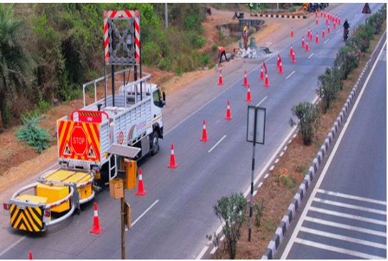
As India aggressively expands its National Highway network, the Ministry of Road Transport and Highways (MoRTH) has shifted its focus from mere connectivity to achieving global standards in road safety. A critical component of this transition is the deployment of Truck Mounted Attenuators (TMAs), a technology-driven intervention designed to safeguard both highway commuters and the personnel maintaining India's high-speed corridors.
Understanding Truck Mounted Attenuators (TMAs)
A Truck Mounted Attenuator is an advanced, energy-absorbing safety device attached to the rear of a service vehicle. It acts as a sacrificial barrier, designed to crumple and absorb the kinetic energy of an errant vehicle before it can strike maintenance crews or construction machinery further ahead.
Key Technical Standards
To ensure reliability, the units deployed on Indian highways comply with rigorous international crash-test protocols:
- MASH Test Level-3 (TL-3): This modern standard ensures the device can handle impacts from heavier vehicles at higher speeds.
- NCHRP 350 Test Level-3: A globally recognized benchmark for roadside safety hardware.
- Impact Resilience: These systems are engineered to withstand and dissipate the force of a collision at speeds of up to 100 km/h.
Core Functions and Impact Mitigation
The deployment of TMAs serves a dual purpose: active prevention and passive protection.
1. Kinetic Energy Dissipation: In the event of a rear-end collision, the attenuator structure collapses in a controlled manner. This dissipation of force significantly:
- Reduces the severity of injuries for the occupants of the crashing vehicle.
- Prevents the service truck from being pushed forward into the maintenance zone where workers are operating.
2. Early Warning Systems: Prevention is achieved through integrated Wig-Wag Warning Lights. These high-intensity lights flash in alternating patterns to form clear directional arrows. This is particularly vital in:
- High-speed corridors where reaction times are minimal.
- Low-visibility conditions, such as heavy fog or nighttime operations.
- Advanced Alerting: By providing a visual cue well in advance, these signals nudge drivers to change lanes safely, preventing the accident entirely.
Strategic Significance for India
The integration of TMAs into the Indian road ecosystem carries profound implications:
- Reduction in Work-Zone Fatalities: Construction zones are high-risk environments. TMAs provide an "invisible shield" for ground workers who are often vulnerable to speeding traffic.
- Economic Resilience: By minimizing accident severity, the government reduces the massive economic loss associated with road fatalities and long-term disability.
- Global Best Practices: The move aligns India with the infrastructure standards of developed nations, making Indian highways safer for international logistics and transit.