Melting Himalayan Glaciers and Emerging Cryospheric Hazards
- 17 Mar 2026
In News:
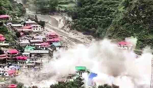
A recent ISRO study published in NPJ Natural Hazards has highlighted that the August 2025 Dharali flash flood in Uttarakhand was triggered by the collapse of an exposed ice patch on the Srikanta Glacier. This finding marks a significant shift in the understanding of Himalayan disasters, as it moves attention away from large glacial lake outburst floods (GLOFs) toward smaller, often overlooked cryospheric instabilities caused by rapid deglaciation.
Understanding Glacier Melting (Deglaciation)
Glacier melting, or deglaciation, refers to the reduction in a glacier’s mass and volume when ice loss through melting and sublimation exceeds the accumulation of snowfall. With rising temperatures, the protective snow and firn layers thin out, exposing older and structurally weak ice. These exposed ice patches become highly unstable and can collapse, triggering flash floods even in the absence of large glacial lakes.
Insights from the Dharali Flash Flood
The Dharali disaster demonstrated that small-scale geomorphic processes can have large-scale impacts. The flood was caused by the collapse of an ice patch located within a nivation hollow on a steep slope of the Srikanta Glacier. This challenges the conventional focus on GLOFs as the primary source of glacial hazards and underscores the importance of monitoring micro-level changes in glacial landscapes.
Data and Trends on Glacier Melting
Recent data indicate that Himalayan glaciers have been losing ice at an average rate of nearly 0.5 metres of vertical height annually since 2000. The Hindu Kush Himalaya region is warming faster than the global average, with projections suggesting that up to 75% of glacier volume could be lost by 2100. This has serious implications for water security, as over 1.3 billion people depend on rivers originating from these glaciers. While initial melting may increase river flows, it eventually leads to long-term water scarcity. Additionally, the frequency of glacial hazards such as GLOFs and similar events has tripled over the past two decades.
Factors Contributing to Glacier Instability
The increasing instability of glaciers can be attributed to multiple interrelated factors. Rising atmospheric temperatures reduce snow cover and expose darker ice, which absorbs more heat and accelerates melting, as observed in the Srikanta Glacier. Black carbon deposition from biomass burning and vehicular emissions further intensifies melting by lowering the albedo of glaciers, with significant impacts seen near the Gangotri Glacier. Changes in precipitation patterns, particularly the shift from snowfall to rainfall at high altitudes, hinder glacier recharge, as seen in Ladakh. Infrastructure development, including road construction and tunnelling in fragile mountain ecosystems, creates localized disturbances and increases slope instability. Moreover, geomorphic processes like nivation-characterized by repeated freezing and thawing, gradually weaken slopes and create hollows that can collapse suddenly, as in the Dharali event.
Government Initiatives and Scientific Efforts
India has undertaken several initiatives to monitor and mitigate glacier-related risks. The National Mission for Sustaining the Himalayan Ecosystem (NMSHE) focuses on understanding glacier dynamics and ecosystem resilience. ISRO has been actively using satellite technologies such as Cartosat and RISAT to map over 9,500 glaciers and assess potential risks. Early Warning Systems have been installed in vulnerable regions like the Rishiganga and Dhauliganga valleys following past disasters. Additionally, international collaborations, such as Indo-Swiss programmes, are enhancing research capabilities and climate resilience strategies in the Himalayan region.
Challenges in Glacier Monitoring and Management
Despite these efforts, several challenges persist. The rugged and inaccessible terrain of the Himalayas makes it difficult to install and maintain monitoring infrastructure. There is also a lack of long-term historical data, which limits the ability to predict rare events such as ice-patch collapses. Transboundary issues further complicate glacier management, as many glaciers span across India, China, and Pakistan, restricting coordinated research and data sharing. Socio-economic vulnerabilities are high, as communities often reside in narrow valleys prone to sudden flooding. Additionally, unpredictable micro-climatic conditions make it difficult to anticipate disasters, as seen in past events like the Chamoli avalanche.
Way Forward
Addressing these emerging risks requires a multi-pronged approach. Integrated monitoring systems that combine satellite observations with ground-based sensors should be developed to track both large and small-scale glacial changes. Disaster frameworks must expand beyond GLOFs to include hazards like ice-patch collapses and nivation processes. Community participation is crucial, and local populations should be trained to recognize early warning signs such as exposed ice surfaces. Infrastructure development in Himalayan regions must be made climate-resilient, with strict environmental impact assessments. Regional cooperation among Himalayan countries is essential for effective data sharing and coordinated response. Furthermore, systematic mapping of vulnerable slopes and nivation zones can help in identifying high-risk areas.
Conclusion
The Dharali flash flood highlights the evolving nature of Himalayan hazards in the context of climate change. As glaciers continue to recede, new forms of instability are emerging, necessitating a shift from traditional monitoring approaches to more comprehensive, ridge-to-valley surveillance systems. Protecting the fragile Himalayan ecosystem is not only an environmental priority but also critical for ensuring the safety, livelihoods, and water security of millions of people dependent on these mountains.