PKC-ERCP: Rajasthan’s River-Linking Project
- 25 Jan 2025
In News:
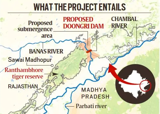
The Parbati-Kalisindh-Chambal-Eastern Rajasthan Canal Project (PKC-ERCP), part of the National Interlinking of Rivers (ILR) programme, aims to address water scarcity in 23 districts of Rajasthan, potentially benefiting 3.45 crore people. However, it has raised serious concerns over its ecological impact, particularly on the Ranthambore Tiger Reserve.
About the PKC-ERCP Project:
Aspect Details
Objective To channel surplus water from the Chambal basin for irrigation, drinking, and industrial use in Rajasthan and Madhya Pradesh
Estimated Cost ?72,000 crore (90% funded by the Central Government)
Water Allocation 4,100 MCM to Rajasthan and 3,000 MCM to Madhya Pradesh
Rivers Involved Chambal, Parbati, Kalisindh, Banas, and tributaries
Major Structure 39 m high, 1.6 km long dam across the Banas River, a Chambal tributary, near Doongri village, ~30 km from Sawai Madhopur
Submergence and Environmental Concerns:
- Total Submergence: ~408.86 sq km in Rajasthan.
- Reservoir Impact: 227 sq km to be submerged under the proposed dam across Banas River.
- Impact on Tiger Reserve:
- 37.03 sq km of the Ranthambore Tiger Reserve (total area: 1,133 sq km) to be submerged.
- This includes parts of Ranthambore National Park (392 sq km) and Keladevi Wildlife Sanctuary (674 sq km).
- May fragment the reserve, disrupting wildlife corridors and tiger movement.
- Ranthambore’s Significance:
- Home to ~57 tigers, it is one of India’s most prominent conservation areas.
- Situated at the Aravalli-Vindhya junction, with rich biodiversity, including leopards, hyenas, sloth bears, and iconic flora like Dhok trees.
- Encompasses the UNESCO-listed Ranthambore Fort and the Great Boundary Fault.
Arguments For the Project:
- Addresses chronic water scarcity in eastern Rajasthan.
- Promotes agricultural productivity, drinking water security, and industrial development.
- Aims to optimize water use by diverting surplus flows.
Arguments Against the Project:
- Biodiversity loss due to habitat submergence and reserve fragmentation.
- Risks to tiger conservation efforts.
- Potential violation of environmental safeguards under the Wildlife Protection Act and Forest Conservation norms.
Long-term ecological costs may outweigh short-term developmental gains.
Indian Coffee Sector
- 21 Jan 2025
In News:
India is now the seventh-largest coffee producer globally with exports reaching $1.29 billion in FY 2023-24, almost double the $719.42 million in 2020-21.
Historical Background
- Origin: Coffee was introduced to India in the 17th century by Baba Budan, a Sufi saint, who brought seven Mocha beans from Yemen and planted them in Baba Budan Giri hills, Karnataka.
- This act laid the foundation for India’s coffee cultivation, which has since evolved into a robust agro-industry.
India’s Global Coffee Status
- 7th largest coffee producer globally (FY 2023–24).
- Exports: Reached $1.29 billion in FY 2023–24, nearly double the $719.42 million in FY 2020–21.
- Major export destinations: Italy, Belgium, Russia.
- Export Share: Over 70% of India's coffee is exported, mostly in unroasted (green bean) form.
Types of Coffee Cultivated
- Arabica: Mild flavor, higher market value.
- Robusta: Strong flavor, more robust; often used in instant coffee.
- India's production: Around 75% is a mix of Arabica and Robusta.
Geographical Distribution
- Major Coffee-Growing Regions:
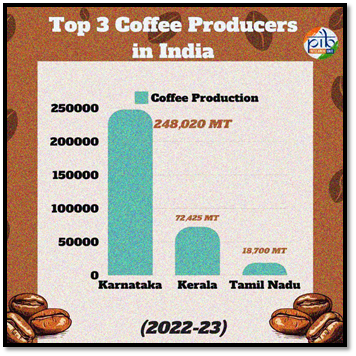
- Karnataka: Leads with over 70% of national production (~248,020 MT in 2022–23).
- Kerala and Tamil Nadu follow.
- Other contributors: Andhra Pradesh, Odisha, and parts of Northeast India
- Agro-climatic Conditions:
- Altitude: 600–1600 meters
- Temperature: 15°C–28°C
- Rainfall: 150–250 cm annually
- Soil: Well-drained, loamy, rich in humus and minerals
Economic & Environmental Significance
- Coffee is largely grown in the Western and Eastern Ghats, biodiversity-rich zones with shade-grown plantations.
- These plantations:
- Conserve ecology and biodiversity
- Support sustainable agriculture
- Contribute to rural livelihoods
Domestic Trends
- Rising café culture, urbanization, and higher disposable incomes have led to increased coffee consumption.
- Domestic consumption rose from 84,000 tonnes (2012) to 91,000 tonnes (2023).
- Preference for coffee over tea is growing, especially in urban and semi-urban India.
Government Initiatives
- Coffee Board of India initiatives under the Integrated Coffee Development Project (ICDP) aim to:
- Enhance yields
- Expand to non-traditional areas
- Promote sustainable practices
- Araku Valley Model:
- Involves 150,000 tribal families
- 20% increase in production
- Backed by Girijan Co-operative Corporation (GCC) and Integrated Tribal Development Agency (ITDA)
- Aligned with Aatmanirbhar Bharat and rural empowerment
Current Challenges and Future Outlook
- Challenges: Climate change impacts, pest attacks, price volatility in global markets.
- Opportunities:
- Rising global demand for value-added products (roasted & instant coffee)
- Export incentives and improved logistics
- Potential for agri-tourism and organic branding
India’s Recalculated Coastline
- 09 Jan 2025
In News:
India’s coastline has grown significantly over the past five decades, now extending 11,098 km in 2023-24, compared to 7,516 km in 1970. This marks an increase of 47.6% in just over five decades, attributed to a more precise methodology for measuring coastlines.
Key Factors Behind the Growth:
New Methodology for Measuring Coastlines:
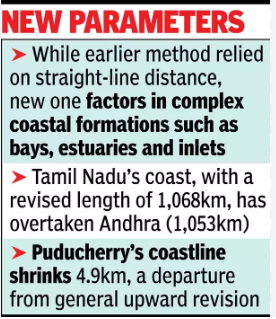
- The old methodology used straight-line distances to measure the coastline, a method that didn't capture the complexity of India’s coastlines.
- The updated approach incorporates bays, estuaries, inlets, and other geomorphological features, offering a more accurate and detailed representation of the coastline.
- Advanced technologies like geospatial mapping have been used to ensure greater precision.
State-wise Recalculated Coastline Changes:
- Gujarat:
- Old coastline (1970): 1,214 km
- New coastline (2023-24): 2,340 km
- Growth: The largest absolute increase in coastline, nearly doubling its size.
- West Bengal:
- Old coastline: 157 km
- New coastline: 721 km
- Growth: A dramatic 357% increase, marking the highest percentage rise.
- Tamil Nadu:
- Old coastline: 906 km
- New coastline: 1,068 km
- Growth: Revised length now exceeds Andhra Pradesh’s coastline, which was 1,053 km.
- Puducherry:
- Old coastline: No major shift, but the updated data shows a contraction of 4.9 km (-10.4%), due to erosion and recalculations.
- Kerala:
- Old coastline: Relatively small increase of 30 km (5%), the smallest among the states.
Notable Observations:
- Andhra Pradesh is developing new ports like Ramayapatnam, Krishnapatnam, and Kakinada Gateway, aiming to boost economic growth and employment by leveraging its expanding coastline.
- The recalculated coastline helps in better maritime planning, focusing on port development, tourism, biodiversity conservation, and coastal erosion.
Impact of Coastline Expansion:
- Economic Growth:
- Coastal states, particularly Gujarat and West Bengal, benefit from an expanded coastline that improves maritime trade, port infrastructure, and tourism.
- The expansion supports industrialization, with growing logistics and transportation activities along the coast.
- Environmental Considerations:
- The new data aids biodiversity conservation, helping to track coastal erosion and accretion (land buildup), especially in areas like the West Coast.
- Understanding these changes is essential for disaster preparedness and sustainable coastal management.
- Coastlines of Emergence and Submergence:
- Emerging Coastlines: Land rising due to uplift or falling sea levels, such as along the Tamil Nadu Coast.
- Submerged Coastlines: Land that has sunk or been submerged due to rising sea levels, particularly noticeable along parts of Kerala’s coast.
Geographical Significance of the Expanded Coastline:
- India’s coast touches three major bodies of water: the Bay of Bengal (east), the Indian Ocean (south), and the Arabian Sea (west).
- The expansion reflects more than just geography—accurate coastline data is crucial for policy planning, maritime security, and resource management.
Netravati River
- 23 Mar 2024
Why is it in the News?
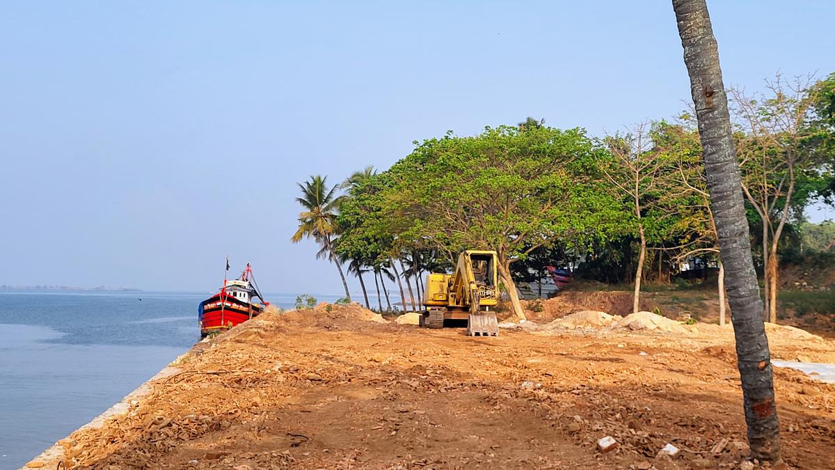
The principal bench of the National Green Tribunal (NGT) in New Delhi has initiated action on the Netravati Waterfront Promenade Development Project in Mangaluru.
About the Netravati River:
- The Netravati River, also known as Netravathi Nadi, originates from the Bangrabalige valley, Yelaneeru Ghat in Kudremukh, Chikkamagaluru district, Karnataka, India.
- It passes through the revered pilgrimage site Dharmasthala, earning recognition as one of India's sacred rivers.
- Converging with the Kumaradhara River at Uppinangadi, it eventually flows into the Arabian Sea, south of Mangalore city, serving as the primary water source for Bantwal and Mangalore.
- The Netravati railway bridge, a prominent structure, acts as the gateway to Mangalore.
- Historically known as the Bantwal River, it was documented as unfordable during the South-West Monsoon in the 1855 Gazetteer of Southern India.
- The river's navigability by small country craft and its influence on local geography and transport, including the naming of the Netravati Express train, underscores its significance in the region's history.
- Instances of flooding, notably in 1928 and 1974, have shaped the lives of residents, prompting relocations and resilience
About the National Green Tribunal:
- The National Green Tribunal (NGT) was established under the National Green Tribunal Act of 2010.
- While its principal seat is located in New Delhi, it also holds sessions in Bhopal, Pune, Kolkata, and Chennai.
- The NGT is entrusted with the responsibility of adjudicating applications or appeals, ensuring their final disposition within six months of filing.
Composition:
- The tribunal comprises a Chairperson, Judicial Members, and Expert Members, each serving a non-renewable term of five years.
- The appointment of the Chairperson is made by the Central Government in consultation with the Chief Justice of India (CJI).
- A Selection Committee, constituted by the Central Government, is responsible for appointing both Judicial and Expert Members.
- The tribunal can accommodate a minimum of 10 and a maximum of 20 full-time Judicial and Expert Members.
Powers & Jurisdiction:
- Established to efficiently handle cases concerning environmental protection and conservation of natural resources, including forests.
- It possesses appellate jurisdiction akin to a court.
- While not bound by the procedural formalities outlined in the Code of Civil Procedure, 1908, the NGT operates based on the principles of natural justice.