Nahargarh Wildlife Sanctuary
- 04 Aug 2025
In News:
The Rajasthan Forest Department has recently redrawn the boundaries of the Nahargarh Wildlife Sanctuary (NWS), located near Jaipur, sparking controversy among conservationists and legal experts. The move, alleged to benefit luxury hotels and commercial establishments within the sanctuary and its Eco-Sensitive Zone (ESZ), has raised questions about legality, ecological safeguards, and governance.
About Nahargarh Wildlife Sanctuary
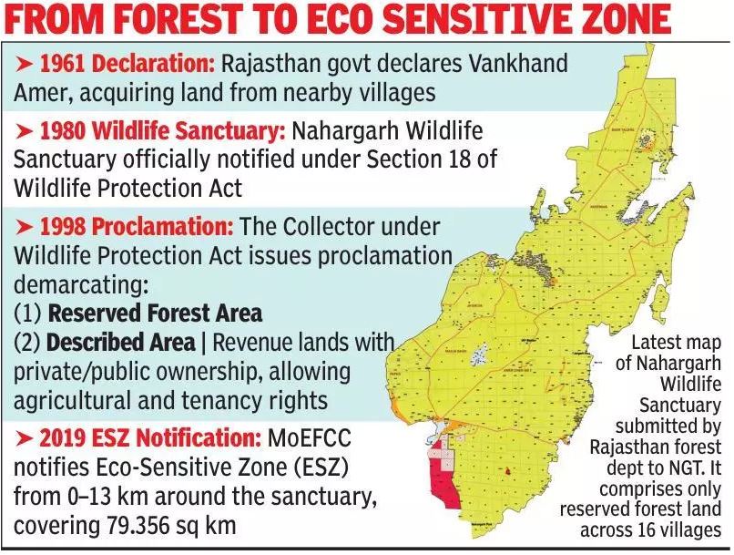
- Location: ~20 km from Jaipur, under the Aravalli range.
- Size: Originally ~720 hectares; currently notified as 6,025.74 hectares across 16 villages.
- History: Named after Nahargarh Fort, built by Maharaja Sawai Jai Singh II in the 18th century.
- Nahargarh Biological Park: Part of the sanctuary, noted for its lion safari.
- Flora: Dry deciduous forests, scrublands, grasslands.
- Fauna: Leopards, deer, sloth bears, wild boars, lions, tigers, reptiles like pythons and monitor lizards, and diverse birdlife including owls, eagles, and peacocks.
The Controversy
- Procedural Lapses
- Under Section 26A of the Wildlife Protection Act, 1972, any change in sanctuary boundaries requires approval from the National Board for Wildlife (NBWL).
- Experts cite the 2013 Supreme Court judgment (Centre for Environmental Law, WWF-India vs Union of India), which mandated NBWL clearance for altering protected area limits.
- However, Rajasthan submitted revised maps to the National Green Tribunal (NGT) in July 2025 without NBWL’s recommendation.
- Alleged Motivations
- Activists claim the revised map excludes “Described Areas” (revenue lands held by public and private bodies) while retaining only Reserved Forest patches.
- This adjustment allegedly protects existing luxury hotels and other constructions in the ESZ, some of which earlier faced demolition orders for violations.
- Government’s Justification
- Officials argue the 1980 notification used “grossly approximate” boundary descriptions.
- Over four decades, urbanisation and topographical changes blurred the original limits.
- A GIS-based remapping exercise using high-resolution satellite imagery and land records was undertaken, and state approval was granted in July 2025.