KotadaBhadli
- 29 Oct 2025
In News:
- A recent multidisciplinary research study by Deccan College, Symbiosis School for Liberal Arts, and the Archaeological Survey of India (ASI) has reinterpreted the Harappan settlement of KotadaBhadli in Kutch, Gujarat, as the earliest known caravanserai, dating to the Mature Harappan phase (2300–1900 BCE).
- The study, published in L’Anthropologie (2025), pushes back the origins of organised trade infrastructure in South Asia by nearly 2,000 years, long before the rise of the Silk Route.
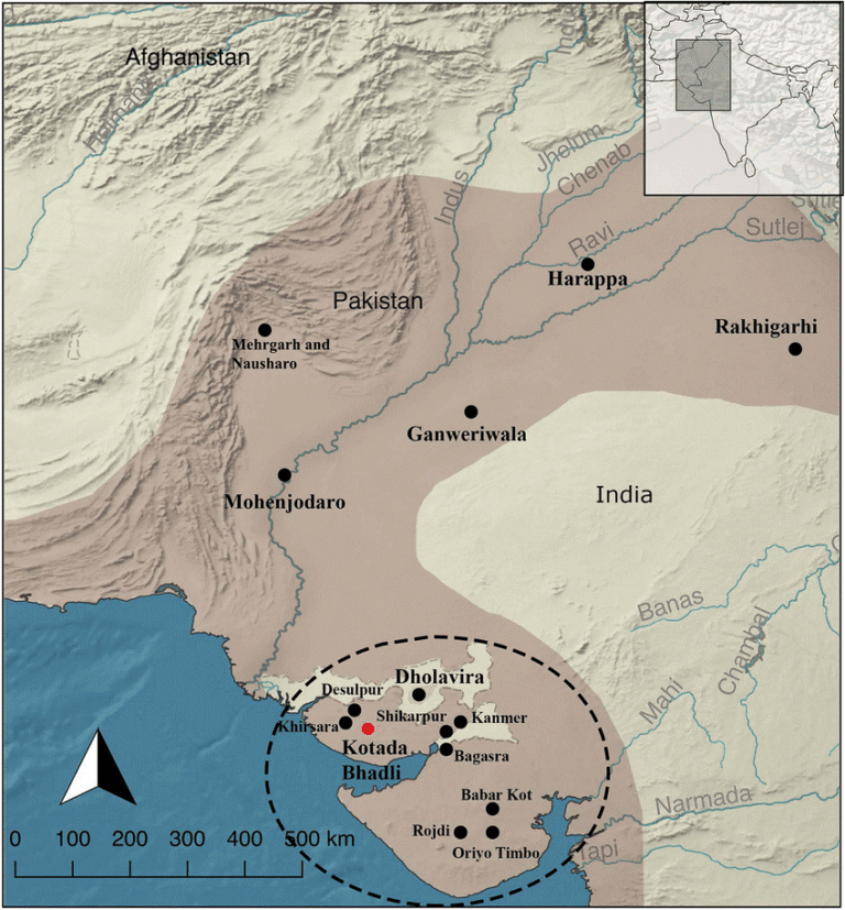
Location and Strategic Significance
- KotadaBhadli lies in the Kutch district of Gujarat, positioned along inland trade corridors linking prominent Harappan centres such as Dholavira, Lothal, and Shikarpur.
- Its placement reveals a purposeful design—serving as a rural logistical stopover facilitating long-distance trade between urban and coastal settlements.
Nature and Function of the Settlement
- Researchers have identified KotadaBhadli as a fortified rural halt, intended not for permanent habitation but for short-term stops by traders and their caravans.
- Its function aligns closely with caravanserai-style establishments known from later historical periods—providing shelter, security, food, and space for pack animals during overland journeys.
- The study clarifies a previously missing link in Harappan commerce: while trade with Mesopotamia and inland India was well documented, the operational mechanism—how traders and goods moved safely across long distances—was not fully understood. KotadaBhadli provides the first archaeological evidence to support this model.
Archaeological and Scientific Evidence
Excavations conducted between 2010 and 2013 and re-analysed through advanced techniques have revealed:
- A multi-roomed central complex, likely functioning as administrative or resting quarters.
- Fortified walls with bastions, confirming its role as a protected stopover.
- Large open courtyards, interpreted as holding areas for animals and storage of goods.
- Remains of food waste and imported material, suggesting active trade activity.
Cutting-edge scientific methods—including ground-penetrating radar, satellite mapping, magnetic surveys, isotopic and lipid analysis, and multiple dating techniques—have improved understanding of the site’s functional layout and confirm its zoning for logistical purposes.
Implications for Harappan Trade Networks
The findings demonstrate that the Harappan economy had a structured overland trade system, supported by a network of small fortified checkpoints rather than solely urban market centres. This reveals an advanced level of planning and coordination within Harappan economic systems.
Key implications include:
- Chronological significance: Organised trade infrastructure existed in South Asia more than two millennia before the Silk Route.
- Economic insight: Harappans displayed sophisticated logistics and administrative planning.
- Civilizational understanding: The Harappan world was not merely dependent on ports like Lothal or trade with Mesopotamia—it also relied on inland support systems that sustained commerce.