Mercator Projection Map
- 27 Aug 2025
In News:
The African Union (AU) has endorsed the “Correct the Map”campaign, calling for the replacement of the Mercator projection with modern alternatives that represent Africa’s true size. This move is not just cartographic—it is deeply political, tied to questions of historical justice, cultural representation, and global perception.
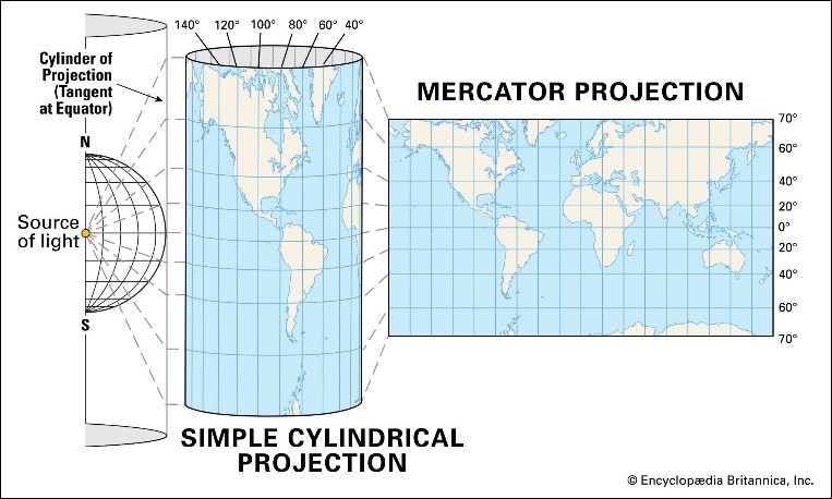
The Mercator Projection: Origins and Features
- Introduced: 1569 by Gerardus Mercator, a Flemish mathematician and cartographer.
- Purpose: Designed for navigation, enabling sailors to follow a straight line of constant compass bearing (Rhumb lines/loxodromes).
- Structure:
- Meridians (longitude): parallel, vertical, equally spaced.
- Parallels (latitude): horizontal, spacing increases away from the equator.
- Grid forms right angles.
- Strengths: Conformal projection that preserves shapes and angles, ideal for maritime exploration.
- Limitations: Distorts area and scale. True scale exists only along the equator; distortion grows near the poles.
Distortions and Bias
- Africa & South America appear much smaller than their real size.
- Europe, North America, and Greenland are disproportionately enlarged.
- Example: Greenland (≈2.1 million sq km) appears similar in size to Africa (≈30 million sq km).
- Such distortions fed into Eurocentric worldviews, reinforcing colonial narratives of Africa as “smaller” and “conquerable.”
Corrective Measures
- Gall-Peters Projection (1970s): Area-accurate but distorts shapes. Adopted in some schools, e.g., Boston (2017).
- Equal Earth Projection (2018): Balances shape and area, providing a fairer representation of continents.
- AU’s Endorsement: By backing the Equal Earth projection, the AU aims to restore “Africa’s rightful place on the global stage,” highlighting the continent’s true scale and importance.