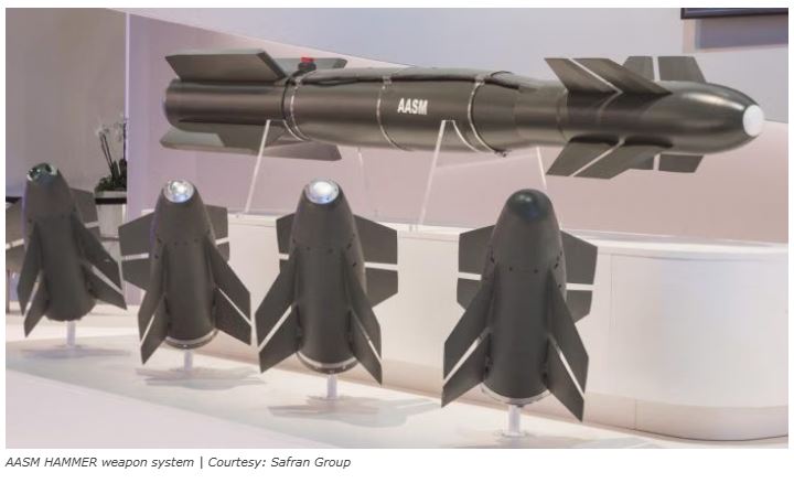
HAMMER Precision Weapon System
- 27 Nov 2025
In News:
India and France have taken a major step in defence industrial cooperation with the signing of a Joint Venture Cooperation Agreement (JVCA) between Bharat Electronics Limited (BEL) and Safran Electronics & Defence (SED) for the manufacture of the HAMMER (Highly Agile Modular Munition Extended Range) precision-guided air-to-ground weapon system in India.
Key Highlights of the Joint Venture
- The proposed Joint Venture Company (JVC) will be incorporated in India as a private limited company with 50:50 shareholding between BEL and Safran.
- Manufacturing, supply, and maintenance of HAMMER will be localised to meet the operational requirements of the Indian Air Force and the Indian Navy, including integration with Rafale and Rafale Marine aircraft.
- Indigenisation will progressively rise to about 60%, covering key sub-assemblies, electronics, and mechanical components.
- Technology and production transfer will occur in phases, with BEL leading final assembly, testing, and quality assurance.
About HAMMER Precision Weapon System
- Type: Smart, precision-guided, air-to-surface weapon
- Developer: Originally developed by Safran (France)
- Configuration: Modular system comprising a guidance kit and a range-extension kit, which can be fitted onto standard general-purpose bombs of different weights.
Key Features
- High Precision: Multiple guidance options (GPS/INS, infrared, laser) enable accurate strikes on hardened targets such as bunkers, shelters, airstrips, and enemy infrastructure.
- Stand-off Capability: Effective strike range of up to ~70 km, allowing launch aircraft to remain outside hostile air-defence envelopes.
- High Agility: Optimised for mountainous and high-altitude terrain, making it suitable for areas like Ladakh.
- Platform Flexibility: Currently integrated with Rafale; planned integration with indigenous platforms like LCA Tejas.
Operational Background
- HAMMER was procured by the IAF under emergency procurement powers to quickly operationalise Rafale aircraft amid heightened security challenges, as it filled a capability gap for shorter-range precision strikes against hardened targets.
- Its selection was influenced by quicker availability and suitability for mountain warfare compared to alternative systems that would have required additional time and cost for integration.
Strategic Significance
- Make in India & Aatmanirbharta: The JV strengthens indigenous defence manufacturing and reduces long-term import dependence in critical precision weaponry.
- Enhanced Strike Capability: Improves India’s ability to conduct accurate, stand-off precision strikes in contested and high-risk environments.
- Cost and Time Efficiency: Local production lowers lifecycle costs, ensures faster availability, and supports sustained operational readiness.
- Industrial Ecosystem & Exports: Encourages technology absorption, skill development, and potential future export opportunities.
Technology Perspective and Capability Roadmap (TPCR) 2025

- 12 Sep 2025
In News:
- The Ministry of Defence (MoD) recently released the Technology Perspective and Capability Roadmap (TPCR) 2025, a strategic blueprint outlining India’s defence technology and capability requirements over the next 15 years.
- The roadmap aims to guide the Indian Army, Navy, and Air Force in modernisation while providing domestic industry, academia, and research institutions early visibility to align R&D and production with future procurement needs. Indigenisation and self-reliance form the core of TPCR 2025.
Objectives of TPCR 2025
- Early Visibility for Industry: Help domestic manufacturers and research organisations plan development and production of advanced defence systems.
- Indigenisation: Reduce dependence on imports and promote domestic defence manufacturing.
- Future-Ready Armed Forces: Equip the military to face multi-domain warfare challenges, including cyber, space, AI-enabled, and hybrid conflicts.
- Sustainability: Integration of green logistics and energy-efficient systems in defence operations.
Key Features by Service
Navy:
- Nuclear Propulsion: Plans to induct 10 nuclear propulsion systems for aircraft carriers and large surface combatants, providing virtually unlimited endurance at sea.
- Next-Generation Aircraft Carrier: Equipped with Electromagnetic Aircraft Launch System (EMALS) to launch heavy fighters, airborne early warning aircraft, and UAVs in all sea states. Digital twin simulations to enable predictive maintenance.
- Surface Combatants: Induction of 5–10 destroyers, 7 corvettes, 4 Landing Platform Docks (LPDs) (~29,000 tonnes each), and 100 Next Generation Fast Interceptor Craft for coastal security.
- Underwater Warfare: 20 high-endurance Autonomous Underwater Vehicles (AUVs) for long-range surveillance and mine countermeasures.
- Missiles & Weapons: Over 200 surface-to-surface missiles and universal launchers for multi-platform deployment.
Army:
- ArmouredModernisation: Replacement of ageing T-72 fleet with 1,800 Future Ready Combat Vehicles (FRCVs); 300–400 light tanks for high-altitude sectors.
- Anti-Tank and Precision Weapons: Procurement of 50,000 ATGMs with tandem HEAT warheads, along with 600,000 artillery rounds, emphasising precision-guided munitions.
- UAV & Robotic Systems: Deployment of 70 MALE/HALE UAVs, 800 integrated drone-loitering munitions systems, and 400 ultra-light missiles for UAVs; over 700 robotic counter-IED systems.
- Cyber & AI Warfare: AI-enabled detection, classification, and adaptive jammers creating 15 km electronic denial zones; deepfake detection tools for operational security.
Air Force:
- Directed-Energy Weapons: 10–15 Tactical High-Energy Laser (THEL) systems with ranges of 6–15 km; high-power microwave systems to neutralise incoming threats.
- Stealth and UAVs: 150 stealth bomber drones for deep-strike missions; 100+ remotely piloted aircraft for ISR and strike roles.
- Persistent Surveillance: 75 High-Altitude Pseudo-Satellites (HAPS) and 20 stratospheric airships for continuous ISR and communications over extended periods.
Tri-Services (Joint):
- Hypersonic Missiles: Induction of 500+ scramjet-propelled hypersonic missiles capable of Mach 5+ speeds for rapid strike across land, sea, and air.
- Universal Missile Launchers: Platforms for multiple missile types to ensure interoperability.
- Cyber-Space Preparedness: AI-as-a-service platforms for 4,000 users, quantum key distribution networks, satellite hardening, and post-quantum secure communications.
Cross-Cutting Technologies
- AI & ML: Smart, predictive warfare through digital twin simulations and autonomous systems.
- Hybrid Warfare Capability: Integration of unmanned systems, robotic tools, and precision-guided munitions.
- Green & Sustainable Defence: Energy-efficient platforms and logistics aligned with national sustainability goals.
Strategic Significance
TPCR 2025 positions India to:
- Achieve self-reliance in defence technologies.
- Maintain credible deterrence and modernisation across all domains.
- Address emerging threats in cyber, space, and multi-domain warfare environments.
- Strengthen domestic defence industrial base through early technology visibility.
Integrated Air Defence Weapon System (IADWS)

- 29 Aug 2025
In News:
India has successfully conducted the maiden flight tests of its Integrated Air Defence Weapon System (IADWS) off the coast of Odisha, marking a major milestone under Project Sudarshan Chakra. Developed indigenously by the Defence Research and Development Organisation (DRDO), the system represents a significant advancement in the country’s ability to defend critical assets against evolving aerial threats.
What is IADWS?
The IADWS is a multi-layered, network-centric air defence architecture that integrates:
- Quick Reaction Surface-to-Air Missile (QRSAM)
- Very Short Range Air Defence System (VSHORADS)
- Directed Energy Weapon (DEW) (high-power laser)
Together, these components form a composite shield capable of engaging a wide spectrum of threats—from high-speed aircraft and cruise missiles to drones, swarm UAVs, and loitering munitions.
Key Features
- Centralised Command & Control Centre (C2C2): Integrates radar and electro-optical sensor data to generate a real-time aerial picture. Based on parameters like speed, altitude, and trajectory, threats are assigned to the most effective weapon.
- Multi-layered Defence:
- QRSAM (outer layer): Intercepts fighter aircraft, helicopters, and standoff precision weapons (cruise missiles, glide bombs) at 25–30 km range and up to 10 km altitude. Highly mobile with short reaction times.
- VSHORADS (middle layer): Infrared seeker-based shoulder-fired missiles to neutralise low-flying UAVs and helicopters within 6 km range and up to 4 km altitude.
- Directed Energy Weapon (inner layer): A DRDO-developed laser system capable of disabling drones and loitering munitions at close range. Offers virtually unlimited firing capacity, making it cost-effective and sustainable.
- Simultaneous Target Engagement: During trials, IADWS successfully intercepted three different aerial targets (two fixed-wing UAVs and a multi-copter drone) in real time.
- Mobility & Flexibility: Mounted on high-mobility launchers, the system can be rapidly deployed in forward areas.
Strategic Importance
IADWS strengthens India’s area defence capability by providing a layered shield for:
- Forward air bases and command centres
- Radar and missile installations
- Nuclear and space assets
- Power plants and critical industrial hubs
By combining kinetic (missiles) and non-kinetic (lasers) weapons under a unified command structure, India has taken a major step toward countering both conventional and asymmetric aerial threats.
Significance for India’s Defence Preparedness
- Enhances self-reliance under Atmanirbhar Bharat in advanced defence technologies.
- Strengthens India’s deterrence against hostile air campaigns, drone swarms, and precision strikes.
- Positions India among a select group of nations with multi-layered integrated air defence systems.
Performance Grading Index (PGI) 2.0
- 20 Jun 2025
In News:
The Ministry of Education released the Performance Grading Index (PGI) 2.0 for the years 2022–23 and 2023–24, offering a comprehensive assessment of school education across States and Union Territories (UTs). This index, aligned with the National Education Policy (NEP) 2020 and Sustainable Development Goals (SDG 4), serves as a critical evidence-based framework for benchmarking educational performance in India.
About PGI 2.0
- Launched: 2017 (PGI 2.0 is the revised version)
- Published by: Ministry of Education, Government of India
- Purpose: Measures performance in school education using a data-driven approach
- Total Indicators: 73 across 6 domains
- Scoring: Out of 1000 points; graded into 10 performance bands:
- Daksh (951–1000) – Top
- Akanshi-3 (401–460) – Lowest
Domains Assessed
- Learning Outcomes and Quality
- Access to Education
- Infrastructure and Facilities
- Equity
- Governance Processes
- Teacher Education and Training
Key Highlights of PGI 2.0 (2022–24)
- Top Performer: Chandigarh with a score of 703, placed in the fifth band – Prachesta-1.
- Lowest Performer: Meghalaya, with 417 points, in the tenth and lowest band – Akanshi-3.
- No State/UT reached the top four bands (Daksh, Utkarsh, Ati Uttam, Uttam), indicating a national gap in quality education.
State-Wise Band Distribution
- Band 5 (Prachesta-1: 701–760): Chandigarh
- Band 7 (581–640): Punjab, Delhi, Gujarat, Odisha, Kerala, Haryana, Goa, Maharashtra, Rajasthan, and Dadra & Nagar Haveli & Daman & Diu
- Band 8 (521–580): 14 States/UTs
- Band 9 (461–520): 10 States/UTs
- Band 10 (Akanshi-3: 401–460): Meghalaya (only State in this band)
Performance by Domains
- Learning Outcomes: No State achieved the top four bands. Chandigarh, Punjab, and Puducherry performed relatively better (Prachesta-2).
- Access to Education: Odisha alone achieved the highest band (Daksh), while Bihar and Jharkhand showed notable progress.
- Infrastructure: Only Chandigarh featured in the third band (Ati Uttam), with Delhi and Dadra & Nagar Haveli in the next.
- Equity: All States placed in the top three bands, indicating relatively balanced access among social groups.
- Governance & Monitoring: Chandigarh excelled through digital governance and transparent fund utilization.
Significance for Policy and NEP 2020
- PGI 2.0 is pivotal in monitoring NEP 2020 implementation, especially for early-grade learning, infrastructure enhancement, equity, and governance.
- It identifies strengths and challenges, enabling targeted policy interventions.
- Despite infrastructure and access gains, quality of learning remains the most critical challenge.
AI-Based Real-Time Forest Alert System
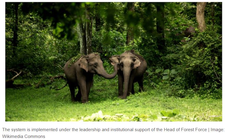
- 04 May 2025
In News:
Madhya Pradesh has become the first state in India to implement an AI-based Real-Time Forest Alert System (RTFAS), marking a significant leap in leveraging technology for sustainable forest management.
Key Highlights
- The AI-based Real-Time Forest Alert System integrates satellite imagery, machine learning, and mobile app feedback for proactive forest monitoring.
- The system is currently being piloted in five forest divisions: Shivpuri, Guna, Vidisha, Burhanpur, and Khandwa—regions with high incidences of encroachment and deforestation.
- Developed using the Google Earth Engine, the system analyses multi-temporal satellite data to detect land use changes, such as:
- Encroachment
- Tree felling
- Construction
- Agricultural expansion
Features of the AI System (RTFAS)
- Custom AI Model: Detects forest degradation by comparing satellite images from three different dates.
- Real-Time Alerts: Sent to forest staff via a mobile application, enabling instant field verification with:
- GPS-tagged photographs
- Voice notes
- Geo-fencing tools
- Interactive Dashboard: Displays live alerts categorized by beat and region with filters for area, density, and time.
- Data Enrichment: Includes indices such as:
- NDVI (Normalized Difference Vegetation Index)
- SAVI (Soil Adjusted Vegetation Index)
- EVI (Enhanced Vegetation Index)
- SAR (Synthetic Aperture Radar)
Forest Status in Madhya Pradesh & India
- Madhya Pradesh:
- Has the largest forest cover in India: 85,724 sq. km (India State of Forest Report 2023)
- Also reported the highest deforestation: 612.41 sq. km lost in 2023
- India:
- Forest and tree cover: 25.17% of total geographical area
- Below the 33% target set by the National Forest Policy, 1988
Role of Technology in Forest Conservation
Application Technology Used
Forest Monitoring AI + Satellite imaging (e.g., RTFAS)
Forest Fires AI cameras, thermal sensors, satellite constellations (e.g., FireSat), drones
Encroachment Detection Satellite alerts with 2–3 day response time
Human-Wildlife Conflict AI camera traps, GPS tracking, RFID tags, geofencing
Afforestation Green bots for planting and monitoring tree growth
Biodiversity Monitoring Acoustic AI (e.g., Rainforest Connection), Environmental DNA (eDNA)
India’s Initiatives for Sustainable Forest Management
Government Initiatives:
- Green India Mission: Increased forest cover by 0.56% (2017–2021)
- National Agroforestry Policy (2014): Promotes tree farming on private lands
- CAMPA (Compensatory Afforestation Fund): Reforestation of diverted forest lands
- Trees Outside Forests in India (TOFI): Involves private stakeholders in increasing green cover
Community & Corporate Involvement:
- CSR-driven plantations by auto, cement, and energy sectors
- Agroforestry: Integrates timber, fruit, and medicinal plants with crops
- Carbon Credit-linked Afforestation
Raisina Dialogue 2025

- 15 Mar 2025
In News:
The 10th edition of the Raisina Dialogue, India’s premier conference on geopolitics and geo-economics, is scheduled to be held in New Delhi from March 17–19, 2025.
About Raisina Dialogue:
- Launched: 2016
- Organisers: Observer Research Foundation (ORF) in collaboration with the Ministry of External Affairs, Government of India
- Format: Multi-stakeholder, cross-sectoral conference bringing together global leaders in politics, business, media, academia, and civil society
- Modelled On: Munich Security Conference (Germany) and Shangri-La Dialogue (Singapore)
- Annual Venue: New Delhi
- 2025 Theme: Kalachakra: People. Peace. Planet.
Significance for India and the World:
- Provides a platform for dialogue on global strategic and security issues
- Enhances India’s image as a thought leader in international diplomacy
- Fosters multilateral cooperation on contemporary global challenges such as conflict resolution, climate change, technological disruption, and global governance
- Reflects India’s growing role as a bridge between the Global North and Global South
Cities Coalition for Circularity (C-3)
- 09 Mar 2025
In News:
Manohar Lal, Union Minister for Housing and Urban Affairs, announced the Cities Coalition for Circularity (C-3), a multi-nation alliance for city-to-city collaboration, knowledge-sharing, and private sector partnerships.
- Platform: 12th Regional 3R and Circular Economy Forum in Asia and the Pacific
- Venue: Rajasthan International Centre, Jaipur, Rajasthan
What is C-3?
- The Cities Coalition for Circularity (C-3) is a multi-national alliance aimed at enhancing city-to-city collaboration, knowledge-sharing, and public-private partnerships.
- It focuses on promoting circular economy principles, resource efficiency, and low-carbon development.
Organizers and Supporters:
- Organized by: Ministry of Housing and Urban Affairs (India), United Nations Centre for Regional Development (UNCRD), and Institute for Global Environmental Strategies (IGES)
- Supported by: United Nations ESCAP, Ministry of Environment (Japan), and other global organizations
Key Announcements:
- Formation of a Working Group to finalize the coalition’s structure and operational framework
- Adoption of the Jaipur Declaration (2025–2034) – a nonpolitical, nonbinding declaration guiding the next decade of action for resource-efficient and sustainable urban growth
Highlights of the Forum:
- Theme: Realizing Circular Societies Towards Achieving SDGs and Carbon Neutrality in Asia-Pacific
- 3R India Pavilion: Inaugurated by Union Minister and Rajasthan CM Bhajanlal Sharma, showcasing 40+ Indian and Japanese start-ups in waste management and circular solutions
What is a Circular Economy?
A circular economy is a regenerative system where:
- Products, materials, and resources are maintained in use for as long as possible
- Waste is minimized through reuse, recycling, remanufacturing, composting, etc.
- It aims to decouple economic growth from resource consumption, addressing climate change, pollution, and biodiversity loss.
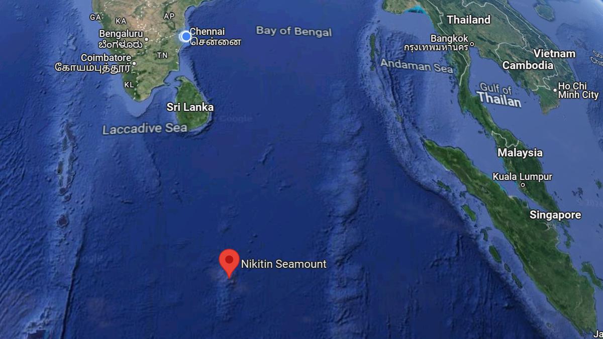
Carlsberg Ridge & Afanasy-Nikitin Seamount
- 28 Mar 2024
Why is it in the News?
Indian delegates have been visiting the International Seabed Authority (ISA), Jamaica to strengthen efforts to explore two deep sea regions in the Indian Ocean for mining, according to reports this week.
What is the Carlsberg Ridge?
- The Carlsberg Ridge is the northern section of the Central Indian Ridge, a divergent tectonic plate boundary between the African Plate and the Indo-Australian Plate, traversing the western regions of the Indian Ocean.
- The ridge of which the Carlsberg Ridge is a part extends northward from a triple point junction near the island of Rodrigues (the Rodrigues Triple Point) to a junction with the Owen Fracture Zone.
- The ridge started its northwards propagation in the late Maastrichtian and reached the incipient Arabian Sea in the Eocene.
- Then it continued to accrete basalt but did not propagate for nearly 30 million years ago.
- Then, in the early Miocene, it started to propagate westwards towards the Afar hot spot, opening the Gulf of Aden.
- The Carlsberg Ridge is seismically active, with a major earthquake being recorded by the U.S. Geological Survey at 7.6 on the moment magnitude scale in July 2003.
- The ridge was discovered by the Danish research vessel Dana during the Carlsberg Foundation's Oceanographic Expedition around the world (1928–1930), better known as the 2nd Dana Expedition, and named after the Carlsberg Foundation, which funded the entire expedition and subsequent analysis and publication of results.
About the Afanasy Nikitin Seamount (ANS) Seabed:
- The ANS is a major structural feature in the Indian Ocean, rising up above the sea bed but below the surface, and forming a seamount.
- It is 400 km long and 150 km wide, and is located in the Central Indian Basin — southeast of Sri Lanka, right below the equator, to the west of Singapore.
- It was formed about 80 million years ago, while dinosaurs still roamed the Earth.
- The Seamount is named after Afanasy Nikitin, a 15th-century Russian merchant who was one of the first to document his travels to India.
- A black monolith is also erected in his honor at Revdanda, about 100 km away from Mumbai, where he is thought to have first set foot in the country.
- The ANS seamount is about 3,000 km from India’s coast and is rich in cobalt, copper, manganese, and nickel.
What are Seamounts?
- Seamounts are submarine mountains originating from volcanic eruptions beneath the ocean's surface, serving as critical habitats for diverse marine ecosystems.
- Similar to terrestrial volcanoes, seamounts can exhibit varying states of activity, including active, dormant, or extinct stages.
- They typically form near mid-ocean ridges, where tectonic plates separate, allowing magma to ascend and solidify on the seabed.
- Notably, seamounts also emerge near intraplate hotspots and oceanic island chains, such as island arcs, characterized by volcanic and seismic activity.
- These underwater formations hold significant scientific value, offering insights into mantle composition, plate tectonics, and oceanic circulation dynamics.
- Moreover, seamounts play a crucial role in nutrient cycling and marine life proliferation, fostering localized upwelling of nutrient-rich waters that support diverse biological communities.