Glacial Lake Outburst Floods (GLOFs)
- 29 Jul 2025
In News:
- In recent years, Glacial Lake Outburst Floods (GLOFs) have emerged as a critical concern in the Himalayan region, particularly affecting countries like India, Nepal, Bhutan, and China.
- The July 8, 2025, GLOF in Nepal—which washed away a China-built bridge and crippled hydropower plants supplying 8% of Nepal’s electricity—has drawn urgent attention to the increasing frequency and severity of such events.
- For India, especially in the Indian Himalayan Region (IHR), GLOFs pose an escalating risk to lives, infrastructure, and ecological systems due to climate change and unregulated development.
What is a Glacial Lake Outburst Flood (GLOF)?
A GLOF is the sudden, catastrophic release of water from a glacial lake—typically dammed by ice or moraine (glacial debris). The floodwaters often cause massive downstream destruction, marked by:
- Extremely high discharge volumes
- Destructive debris flows
- Short warning times
Types of Glacial Lakes in the Himalayas
- Supraglacial Lakes: Form on the surface of glaciers due to meltwater accumulation. Highly unstable during summer.
- Example: Cirenma Co in Tibet (1981), July 2024 Nepal GLOF.
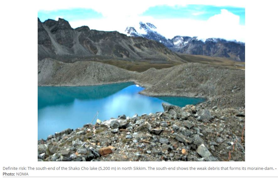
- Moraine-Dammed Lakes: Form at glacier snouts, blocked by weak debris. Most vulnerable to outbursts.
- Example: South Lhonak (Sikkim), Tsho Rolpa (Nepal), Shako Cho (Sikkim)
Causes of GLOFs
Natural Triggers
- Glacial Retreat: Rising temperatures accelerate glacial melt, enlarging lakes.
- Ice or Rock Avalanches: Sudden falls into lakes displace water and rupture dams.
- Cloudbursts & Heavy Rainfall: Rapid rise in water levels increases pressure on dams.
- Seismic Activity: Earthquakes can destabilize moraine dams.
- Internal Piping: Seepage within dams weakens structural integrity over time.
Anthropogenic Factors
- Climate Change: Human-induced warming accelerates glacial melt.
- Unregulated Development: Construction near glacial zones—e.g., hydropower—exacerbates risk.
- Example: Teesta-III dam destruction in 2023.
Impacts of GLOFs
On Human Life and Infrastructure
- Casualties: Kedarnath (2013) and Sikkim (2023) GLOFs caused hundreds of deaths.
- Hydropower & Transport Damage: Washed-out roads, bridges, and dams; loss of electricity and connectivity.
- Displacement & Livelihood Loss: Long-term socio-economic disruption in affected regions.
On Environment
- River Course Changes & Silting: Raised riverbeds and reduced flood-carrying capacity.
- Teesta river rose several meters post-2023 flood.
- Habitat Loss & Biodiversity Decline: Ecological imbalance in alpine and riparian zones.
- Long-Term Ecosystem Stress: Sedimentation affects water quality and ecosystem resilience.
The Situation in India
India’s Himalayan arc—covering J&K, Ladakh, Himachal Pradesh, Uttarakhand, Sikkim, and Arunachal Pradesh—houses:
- 28,000 glacial lakes
- 7,500 lakes above 4,500 m altitude
- 11 major river basins
Yet, the region lacks sufficient monitoring infrastructure and early warning systems, primarily due to remoteness and hostile terrain.
Notable GLOF events:
- Kedarnath (2013): Triggered by cloudburst and glacial melt.
- South Lhonak (2023): Avalanche-triggered breach, damaging a $2 billion hydro project.
India’s Institutional Response to GLOF Risks
1. National Disaster Management Authority (NDMA) Initiatives
India has transitioned from reactive relief to proactive risk mitigation, through:
- National GLOF Programme: A ?150 crore initiative targeting 195 high-risk lakes.
- Committee on Disaster Risk Reduction (CoDRR): Coordinates central and state agencies, scientific institutions, and communities.
2. Five-Pronged Strategy
- Hazard Assessment: Classification of lakes by size, dam type, and downstream threat.
- Automated Weather & Water Stations (AWWS): Real-time monitoring (e.g., in Sikkim).
- Early Warning Systems (EWS): ITBP-led manual alerts; multilingual digital alerts in pilot stages.
- Engineering Interventions:
- Bathymetry and ERT scans
- Artificial channels and retention structures
- Community Engagement:
- Sensitization on religious and ecological concerns.
- Involving locals in scientific expeditions for credibility and access.
Technological Interventions
- SAR Interferometry: Satellite-based technique to detect micro-slope changes.
- Electrical Resistivity Tomography (ERT): Detects ice-cores under moraine dams.
- Unmanned Aerial Vehicles (UAVs): High-resolution terrain mapping.
- Remote Sensing: Tracks surface area growth of glacial lakes (but is post-facto).
Status of Mitigation Efforts
- Expeditions to 40 high-risk lakes in 2024 across J&K, Ladakh, HP, UK, Sikkim, and Arunachal Pradesh yielded positive outcomes.
- Installation of AWWS at lakes in Sikkim providing 10-minute interval data and daily lake imagery.
- ITBP trained for early alerts in absence of automated systems.
- More stations and expeditions are planned post-monsoon 2025.
Transboundary Challenges
- Many GLOF-prone lakes lie in Tibet, with rivers flowing into Nepal, Bhutan, and India.
- Nepal has faced multiple transboundary GLOFs recently (2024–25), with little to no warning from China.
- Example: July 8, 2025 GLOF from Tibet triggered floods in Nepal, destroying infrastructure.
- Past major GLOFs: Cirenma Co (1981), Dig Tsho (1985), Tama Pokhari (1998).
Policy Recommendations
- Strengthen Early Warning Systems: Expand AWWS and EWS coverage, integrate with mobile alerts.
- Transboundary Collaboration: Create shared protocols for upstream monitoring and data exchange with China, Nepal, and Bhutan.
- Integrate Climate Adaptation in Planning: Include GLOF risk in disaster risk reduction and infrastructure resilience planning.
- Ban Critical Infrastructure: Avoid siting major installations near vulnerable glacial zones.
- Promote Indigenous Technology: Invest in SAR, ERT, and AI-based modelling to predict GLOF risks.
- Community-Led Risk Reduction: Involve local populations in monitoring, response planning, and implementation.
Expanding Glacial Lakes in the Indian Himalayas: ISRO
- 27 Apr 2024
Why is it in the News?
Experts express concern over the ISRO analysis findings, indicating that the expansion of glacial lakes due to warming could result in cascading impacts in lower regions.
Highlights of the ISRO Report:
- The ISRO report said 601 glacial lakes, or 89 percent, have expanded more than twice, and 10 lakes have grown between 15 times and double their size. Sixty-five lakes have expanded 1.5 times.
- Of the 2,431 glacial lakes larger than 10 hectares, 676 have significantly expanded, and at least 130 of these lakes are in India 65 (Indus River basin), 7 (Ganga River basin), and 58 (Brahmaputra River basin).
- Elevation-based analysis shows 314 lakes are located in the 4,000 to 5,000 meters range, and 296 lakes are above 5,000 meters elevation.
What are Glacial Lakes?
- Glacial lakes emerge in hollows or basins shaped by glaciers' erosive force and are prevalent in areas where glaciers once existed or persist.
- They vary widely in size and shape, from tiny pools to expansive bodies of water.
- ISRO classifies them into four main types: moraine-dammed, ice-dammed, erosion-based, and 'others'.
- While vital as freshwater sources for rivers, glacial lakes also pose risks, particularly Glacial Lake Outburst Floods (GLOFs).
- GLOFs occur when these lakes discharge large volumes of meltwater, often due to natural dam failures, causing sudden and severe downstream flooding.
Formation Processes:
- Glacial Erosion: Glaciers, moving slowly, sculpt the landscape by eroding bedrock through abrasion and plucking, creating valleys and basins.
- Moraine Deposition: As glaciers move, they transport sediment, depositing it at their edges as moraines, which can act as natural dams, forming lake basins.
- Ice Melting: Rising temperatures or glacier retreat causes ice to melt, filling depressions created by erosion with water, and forming glacial lakes.
- Terminal Moraine Formation: Glaciers may leave behind ridges of sediment at their terminus, creating natural dams that trap water, forming terminal moraine lakes.
Utilization of Remote Sensing for Glacial Lake Monitoring:
- Monitoring glacial lakes in the Himalayan region presents challenges due to rugged terrain, making satellite remote-sensing technology indispensable.
- By analyzing satellite data, changes in glacial lakes can be tracked over time, offering insights into their evolving dynamics.
- This data is vital for understanding their environmental impact and devising strategies to manage risks such as glacial lake outburst floods (GLOFs) and adapt to climate change in glacier-influenced regions.
Mitigating Risks Associated with Glacial Lakes:
- Research suggests that reducing glacial lake levels by 10 to 30 meters can significantly alleviate downstream impacts, albeit not eliminate GLOF risks.
- One effective method involves siphoning off lake water using extended High-Density Polyethylene (HDPE) pipes.
- In 2016, the Sikkim State Disaster Management Authority successfully employed this technique to lower water levels in South Lhonak Lake, showcasing its practicality and efficacy in risk reduction efforts.