India’s Coastline Redefined
- 26 May 2025
In News:
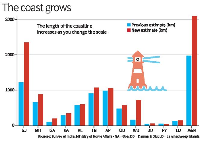
The Ministry of Home Affairs, in its 2023–24 annual report (Dec 2024), announced a significant update to India’s coastline length — revised from 7,516.6 km to 11,098.8 km. This change was not due to any new territorial acquisition or geological activity but resulted from improved measurement techniques, reflecting the "coastline paradox" in geography.
What Is the Coastline Paradox?
The coastline paradox, first explained by British mathematician Lewis Fry Richardson and later expanded by Benoît Mandelbrot, shows that the length of a coastline increases with finer measurement scales. This is because coastlines, like fractals, reveal more detail (creeks, estuaries, inlets) the more closely they are examined.
- Using large-scale maps (e.g., 1:4,500,000), previous estimates missed finer details.
- Modern tools allow capturing every tidal creek, sandbar, and estuarine curve, dramatically increasing measured length.
Measurement Methodology (2024 Update)
Aspect Details
Agencies Involved National Hydrographic Office (NHO), Survey of India
Previous Map Scale 1:4,500,000 (1970s)
New Map Scale 1:250,000 (electronic navigation charts)
Key Technologies GIS, LIDAR-GPS, satellite altimetry, drone imaging
Reference Line Used Highwater Line (based on 2011 data)
Mapped Features Included Tidal creeks, sandbars, estuaries, low-tide islands
Review Frequency Every 10 years from 2024–25
Geographical and Strategic Overview
- India’s New Coastline Length: 11,098.8 km
- No New Land Added: No change in land boundaries or annexation.
- Coastal States & UTs: 11 coastal States + 2 UTs (Andaman & Nicobar Islands, Lakshadweep)
- State with Longest Coastline: Gujarat (~1,600 km)
Why This Matters
1. Maritime Security
- Longer coast = More area to monitor and protect.
- Post-26/11, India enhanced coastal surveillance (radar grid, coastal police).
- Navy and Coast Guard deployment strategies need updates.
2. Disaster Management
- Accurate coastline data helps in cyclone, tsunami early warning systems (e.g., Odisha).
- Supports better Coastal Regulation Zone (CRZ) mapping.
3. Economic and Strategic Planning
- Affects Exclusive Economic Zone (EEZ) and fishing rights.
- Informs infrastructure development: ports, shipping, Sagarmala, tourism.
- Boosts India’s aspirations in the Blue Economy.