France’s Largest Wildfire in Decades
- 09 Aug 2025
In News:
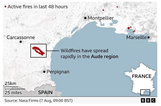
Recently, southern France witnessed its worst wildfire since 1949, scorching nearly 16,000 hectares (39,500+ acres) of forests and villages—an area 1.5 times the size of Paris. Though the blaze has now been contained, firefighters remain deployed to prevent flare-ups and secure the affected zone.
Causes and Challenges
- Climatic Drivers: Officials and France’s Environment Minister attributed the fire’s intensity to climate change, prolonged drought, strong winds, and extremely dry vegetation.
- Geographic Factors: Proximity to the Pyrenees mountains and the Mediterranean coast made the terrain vulnerable to rapid fire spread. Loss of traditional vineyards and land-use changes further accelerated the blaze.
- Future Risks: France’s weather office has warned of fresh heatwaves, increasing wildfire vulnerability across southern Europe.
Geographic Overview of France
- Location: Northern & Eastern Hemispheres; bordered by Belgium, Luxembourg, Germany, Switzerland, Italy, Spain, Andorra.
- Water Bodies: Bounded by the Bay of Biscay (west), English Channel (northwest), and Mediterranean Sea (south).
- Major Rivers:Loire (into Atlantic), Seine (into English Channel).
- Mountain Ranges:Alps, Jura, and Pyrenees (natural border with Spain).
- Resources: Coal, iron ore, bauxite, zinc, uranium, potash, gypsum, etc.
- Overseas Regions: Guadeloupe, French Guiana, Réunion, Martinique, Mayotte.
- Capital: Paris.