Multi-Hazard Early Warning Decision Support System (MHEW-DSS)
- 05 Apr 2026
In News:
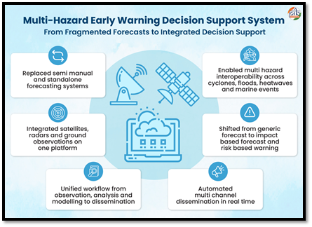
The Multi-Hazard Early Warning Decision Support System (MHEW-DSS) represents a paradigm shift in India’s meteorological capabilities. Developed in-house by the India Meteorological Department (IMD) under the Ministry of Earth Sciences (MoES), it is a flagship digital transformation initiative under Mission Mausam. Launched officially in January 2024, the system transitions India from fragmented, manual forecasting to an integrated, automated, and impact-based warning regime.
Core Objectives and Vision
The primary goal of MHEW-DSS is to build an indigenous, real-time forecasting ecosystem that translates complex scientific data into actionable insights. It aligns with the government’s vision of a "Weather Ready and Climate Smart Nation," encapsulated in the philosophy “Har Har Mausam, Har Ghar Mausam.”
Key Features and Technological Innovations
The MHEW-DSS leverages open-source technology and Geographic Information System (GIS) maps to streamline the forecasting pipeline:
- Automation: Over 90% of weather data collection and quality checks are automated, enabling faster detection of weather systems.
- Enhanced Modeling: The system utilizes more than 95% of Numerical Weather Prediction (NWP) model inputs, a massive leap in data integration.
- Extended Lead Time: Forecast lead time has increased from 5 days to 7 days, providing authorities with a critical window for preparation.
- WAFES Core: The Weather Analysis and Forecast Enabling System (WAFES) serves as the central engine, allowing meteorologists to visualize weather conditions through GIS-based maps and generate real-time alerts.
Economic and Operational Impact
- The implementation of MHEW-DSS has yielded significant tangible benefits across various metrics. It has achieved a 30% improvement in forecast accuracy while reducing the time required to prepare forecasts by 50% (from 6 hours down to 3).
- From a fiscal perspective, the system has saved approximately ?250 crore by eliminating dependence on foreign vendors. Furthermore, the accuracy in predicting cyclone landfall points has reduced evacuation costs to one-third of what they were in 1999. Environmental sustainability is also a key byproduct; the digital workflow saves 23.4 tonnes of paper and approximately 210,240 kWh of electricity annually.
Case Study: Zero Casualty Success
- During Cyclone Biparjoy and Cyclone Dana, the precision of MHEW-DSS enabled timely evacuations, resulting in zero casualties in the affected regions of Gujarat and Odisha.
Sectoral Benefits: Impact-Based Forecasting
The system employs Impact-Based Forecasting, which assesses how weather affects specific socio-economic sectors rather than just predicting rain or wind levels.
- Agriculture: It provides twice-weekly Agromet advisories. Farmers adopting these reports have seen a 52.5% increase in annual income, with potential economic benefits in rain-fed districts estimated at ?13,331 crore.
- Public Health: The system supports Heat Action Plans and aids in predicting vector-borne diseases like Dengue and Malaria by analyzing weather patterns.
- Energy: It optimizes renewable energy planning (Solar/Wind) and protects grid infrastructure from extreme events through early warnings.
- Last-Mile Connectivity (Mausamgram): This hyper-local portal provides location-specific forecasts for over 6.2 lakh villages and 1.5 lakh pin codes, ensuring the most remote citizens are reached.
Institutional Framework
The MHEW-DSS ecosystem is supported by three major pillars:
- Ministry of Earth Sciences (MoES): The nodal ministry providing administrative and scientific oversight.
- India Meteorological Department (IMD): The operational lead responsible for data generation and dissemination.
- Mission Mausam: The strategic umbrella (approved Sept 2024) that funds and guides the enhancement of observation networks, data assimilation, and modeling.
Kavach 4.0

- 13 Mar 2026
In News:
The Government of India has informed the Lok Sabha that Kavach 4.0, India’s indigenous Automatic Train Protection (ATP) system, has been successfully commissioned across 1,452 route kilometres on the high-density Delhi–Mumbai Railway Corridor and Delhi–Howrah Railway Corridor.
The system represents a major technological advancement aimed at improving railway safety and reducing accidents caused by human error. Kavach forms a crucial part of the modernization and safety enhancement efforts of Indian Railways.
What is Kavach?
- Kavach is an indigenously developed Automatic Train Protection (ATP) system designed to prevent train collisions and ensure safer railway operations. It is a sophisticated electronic safety mechanism that automatically monitors train movement and intervenes when necessary.
- The system has been developed by the Research Design and Standards Organisation (RDSO) in collaboration with domestic industry partners, reflecting India’s push toward self-reliance in railway technology.
Objectives of Kavach
The primary objective of Kavach is to achieve “Zero Accidents” in railway operations by addressing key safety risks.
Major goals include:
- Signal Passing at Danger (SPAD), where a train crosses a stop signal.
- Controlling overspeeding of trains.
- Ensuring safe operations during adverse weather conditions, especially dense fog.
- Reducing accidents caused by human error.
Working Mechanism
Kavach operates through an integrated communication and monitoring network that continuously tracks train movement and signal conditions.
The system functions through the following components:
- RFID tags installed along railway tracks
- On-board equipment installed in locomotives
- Radio communication towers at railway stations
These components exchange real-time data regarding the train’s speed, location, and signal status. If the system detects a possible collision, signal violation, or overspeeding, it automatically activates the braking system, even if the loco pilot fails to respond.
Key Features of Kavach 4.0
The Kavach 4.0 version introduces several technological improvements for better reliability and precision.
- Enhanced Precision: The system offers improved location accuracy and better processing of signal information, particularly in complex railway yards and high-density corridors.
- Integration with Electronic Interlocking: Kavach integrates directly with Electronic Interlocking systems, enabling real-time access to track occupancy data and signal status, thereby enhancing operational safety.
- Advanced Communication Network: It uses Optical Fibre Networks (OFN) and Ultra High Frequency (UHF) radio communication to enable continuous station-to-station communication and uninterrupted connectivity.
- Automatic Braking: If a train crosses a red signal or exceeds the permitted speed, the system automatically applies brakes, preventing potential accidents.
- SOSR (Save Our Souls) Feature: The SOSR emergency broadcast system allows a train or station to transmit emergency alerts to all trains within a defined radius, helping prevent large-scale accidents during critical situations.
Significance for Railway Safety
The deployment of Kavach is a major step toward improving the safety standards of Indian Railways.
Key benefits include:
- Reduction in accidents: Consequential train accidents have reportedly declined by nearly 90% since 2014 due to enhanced safety investments.
- Minimization of human error: Automated monitoring and braking reduce dependence on manual response.
- Improved efficiency: Trains can operate at higher speeds safely even during low-visibility conditions such as winter fog.
- Technological self-reliance: The system strengthens India’s indigenous railway technology ecosystem.
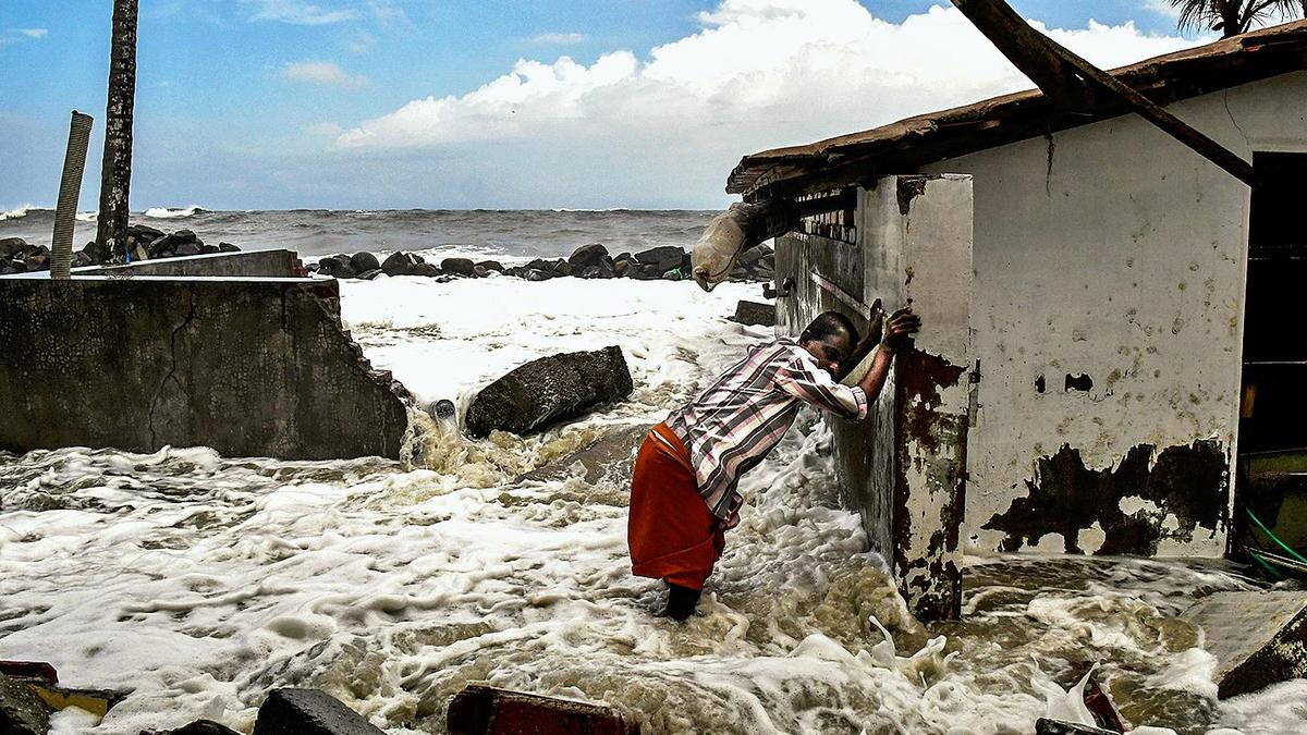
Tidal Flooding
- 19 Feb 2026
In News:
The Government of Kerala has declared tidal flooding as a State-specific disaster. It is the first time in India that a State has accorded such status to tidal flooding.
What is Tidal Flooding?
- Also known as:
- Sunny day flooding
- King tide flooding
- Nuisance flooding
- Definition: Temporary inundation of low-lying coastal areas due to unusually high tides, without heavy rainfall or cyclonic activity.
Causes
- Combination of:
- High tide cycles
- Full moon and new moon phases
- Offshore storms
- Strong coastal winds
- Occurs twice daily with tidal cycles.
- More severe during spring tides (full moon and new moon).
- Unlike cyclone-induced storm surges, it is periodic and predictable, though intensifying due to sea-level rise.
Impact on Kerala Coast
- Common along Kerala’s coastline bordering the Arabian Sea.
- Temporary rise in sea level above identified thresholds.
- Inundates low-lying coastal settlements and agricultural lands.
- Affects fisheries, livelihoods, housing, and infrastructure.
Kerala Government’s Decision
Kerala became the first State in India to declare tidal flooding as a State-specific disaster, enabling financial assistance under SDRF norms.
- Victims will receive financial assistance similar to other notified natural disasters.
- Relief to be provided through the State Disaster Response Fund (SDRF) framework.
Other State-Specific Disasters in Kerala
Kerala has also notified the following as State-specific disasters:
- Coastal erosion
- Lightning
- Strong winds
- Soil piping
- Heatwave / Sunstroke / Sunburn
- Human–wildlife conflict
Significance
Disaster Management Perspective
- Recognises climate-linked coastal risks beyond cyclones.
- Enhances institutional preparedness and targeted relief.
Climate Change Link
- Sea-level rise and coastal vulnerability are increasing frequency and severity.
- Highlights need for coastal zone management and adaptation planning.
Kavach System

- 21 Dec 2025
In News:
The indigenously developed Kavach system, India’s flagship Automatic Train Protection (ATP) technology, has been fully commissioned on over 2,000 km of the Indian Rail network, with its rollout progressing rapidly. This information was provided by the Union Railway Minister in a written reply during the Winter Session of Parliament, highlighting a major milestone in railway safety reforms.
What is Kavach?
Kavach is a home-grown digital safety system designed to prevent train accidents by automatically intervening when unsafe train movements are detected. It has been developed by the Research Design and Standards Organisation (RDSO) under Indian Railways, in collaboration with Indian industry partnersp-Medha Servo Drives Pvt Ltd, HBL Power Systems Ltd, and Kernex Microsystems.
Key Technical Features
- Kavach is a complex integrated safety ecosystem comprising five major components.
- It relies on:
- Continuous Optical Fibre Cable (OFC) laid along tracks
- Telecom towers for uninterrupted data and voice communication
- RFID tags and electronic equipment installed on locomotives, tracks, and signalling systems
- Communication occurs using ultra-high radio frequencies.
- Based on pre-programmed safety logic, the system can:
- Warn loco pilots
- Automatically apply brakes
- Prevent collisions, signal passing at danger (SPAD), and over-speeding
Testing and Deployment
- Field trials began in 2016 on passenger trains before large-scale rollout.
- As of December 2025, Indian Railways has achieved:
- 7,129 km of OFC laid
- 860 telecom towers installed
- 767 railway stations connected to data centres
- Trackside equipment deployed along 3,413 km
- 4,154 locomotives equipped with Kavach
- Around 40,000 railway personnel have been trained to operate and maintain the system.
Impact on Railway Safety
The introduction of Kavach has contributed to a nearly 90% reduction in consequential railway accidents, which declined from 135 incidents in 2014 to about 11 currently. This demonstrates its effectiveness as a preventive safety technology.
Strengthening India’s Tsunami Early Warning System

- 11 Feb 2026
implemented by the Indian National Centre for Ocean Information Services (INCOIS), which operates the Indian Tsunami Early Warning Centre (ITEWC).
Location and Regional Role
- Proposed site: Vijaynagar on Swaraj Dweep, Andaman and Nicobar Islands
- Project cost: ?300 crore
- First-of-its-kind tsunami coordination centre in India
- Will provide warning services to Indian Ocean countries, including Sri Lanka
The Andaman and Nicobar Islands lie close to major tectonic activity zones, making them strategically important for tsunami detection.
Limitations of the Current System
Currently, tsunami warnings are processed at INCOIS headquarters in Hyderabad. The system relies on:
- Seismic signals
- Tidal gauges along the Indian coast
- Surface buoys deployed in the Indian Ocean
- Satellite data
However, the existing system primarily detects earthquake-triggered tsunamis, which account for about 80% of global tsunamis. Nearly 20% are caused by non-seismic sources such as:
- Submarine landslides
- Volcanic eruptions
- Mudslides
Surface buoys are also vulnerable to vandalism and theft, and satellite data sometimes has gaps.
Next-Generation Capabilities
The new RSC will develop a system capable of detecting both seismic and non-seismic tsunamis, significantly enhancing early warning capacity.
Key Technological Features:
- Laying of 270 km-long sub-sea cables along tectonic subduction zones
- Improved monitoring of acoustic signals, which travel faster than conventional seismic signals
- Reduced data gaps compared to surface buoys
Subduction zones are regions where one tectonic plate moves beneath another, often generating earthquakes and volcanic activity.
Vulnerability of Indian Coasts
While India’s east coast has experienced past tsunamis (notably in 2004), experts highlight emerging risks:
- The west coast of India may be vulnerable to non-seismic tsunamis due to fragile marine geology.
- Presence of underwater mud volcanoes along the Makran coast increases risk potential.
- India’s only active volcano at Barren Island in the Andaman Sea also poses a latent threat.
- If an epicentre is located close to the Andaman and Nicobar Islands, the islands themselves could face severe impact.
Indian National Centre for Ocean Information Services (INCOIS)

- 09 Feb 2026
In News:
The Indian National Centre for Ocean Information Services (INCOIS) will launch three new ocean information services-JellyAIIP, SAMUDRA 2.0 Mobile App, and SIVAS, along with a new institutional logo during its foundation day celebrations.
About INCOIS
- Established: 1999
- Status: Autonomous body
- Ministry: Ministry of Earth Sciences (MoES)
- Headquarters: Hyderabad, Telangana
- Mandate:
- Provide ocean information and advisory services to society, industry, government agencies, and the scientific community
- Based on sustained ocean observations and focused scientific research
- International Role: Permanent member of Intergovernmental Oceanographic Commission (IOC) of UNESCO
- Key Infrastructure:
- Established the Indian Tsunami Early Warning Centre (ITEWC), which issues tsunami alerts within 10 minutes
- Serves India and 28 Indian Ocean countries
Major Existing Initiatives of INCOIS
- SARAT (Search and Rescue Aided Tool): Assists Indian Coast Guard, Navy, and Coastal Security Police in locating persons or objects lost at sea
- SynOPS Platform: A data visualisation and integration system for real-time ocean and weather data, improving coordination during extreme events
Newly Launched Ocean Information Services
1. JellyAIIP
- Full Form: Jellyfish Aggregation Information Interactive Portal
- Type: National web-based platform
- Purpose: Reporting and visualisation of jellyfish aggregation, swarming, and stranding events along the Indian coast
- Features:
- Geospatial mapping and hotspot analysis
- Multilingual first-aid guidance for jellyfish stings
2. SAMUDRA 2.0 Mobile App
- Nature: Upgraded version of the existing SAMUDRA platform
- Function: Delivers ocean advisories and early warnings
- Target Users: Fishermen and maritime stakeholders
- Key Feature: Multilingual interface for wider accessibility
3. SIVAS
- Full Form: Swell-Surge Inundation Vulnerability Advisory System
- Type: Coastal inundation early warning service
- Function: Provides advance alerts for swell-surge flooding events
- Current Coverage: Operational for the Kerala coast
- Output: Multilingual forecast bulletins
Significance
- Enhances coastal hazard preparedness and marine safety
- Strengthens early warning systems for fishermen and coastal communities
- Supports climate resilience and disaster risk reduction along India’s coastline
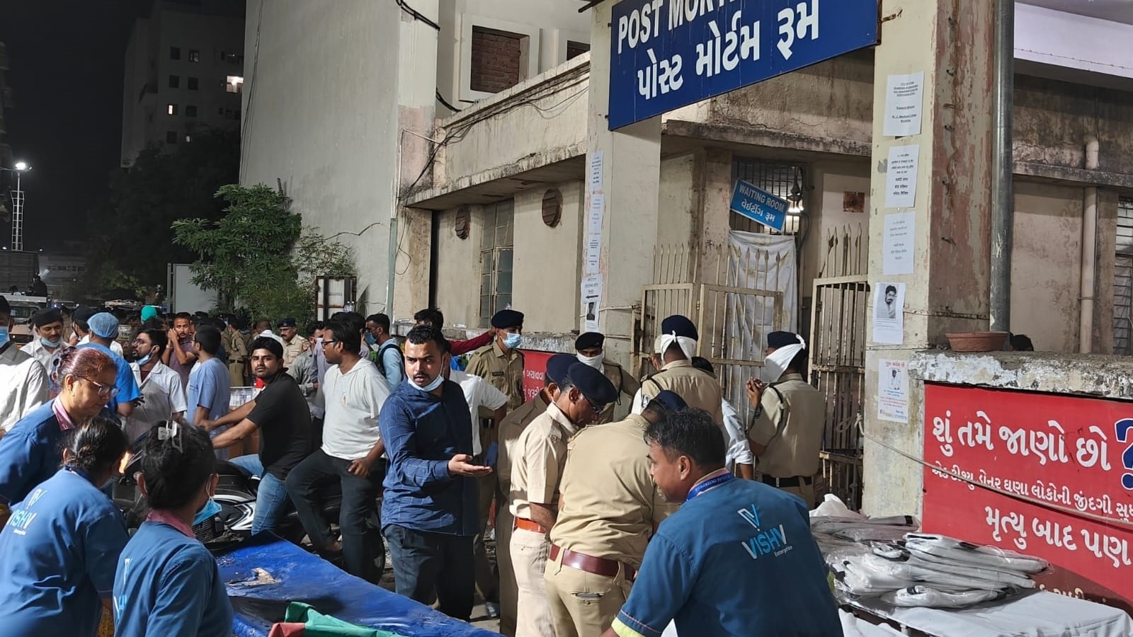
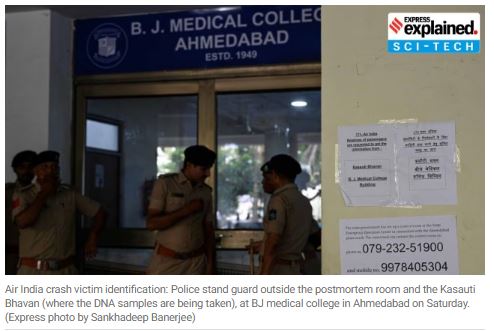
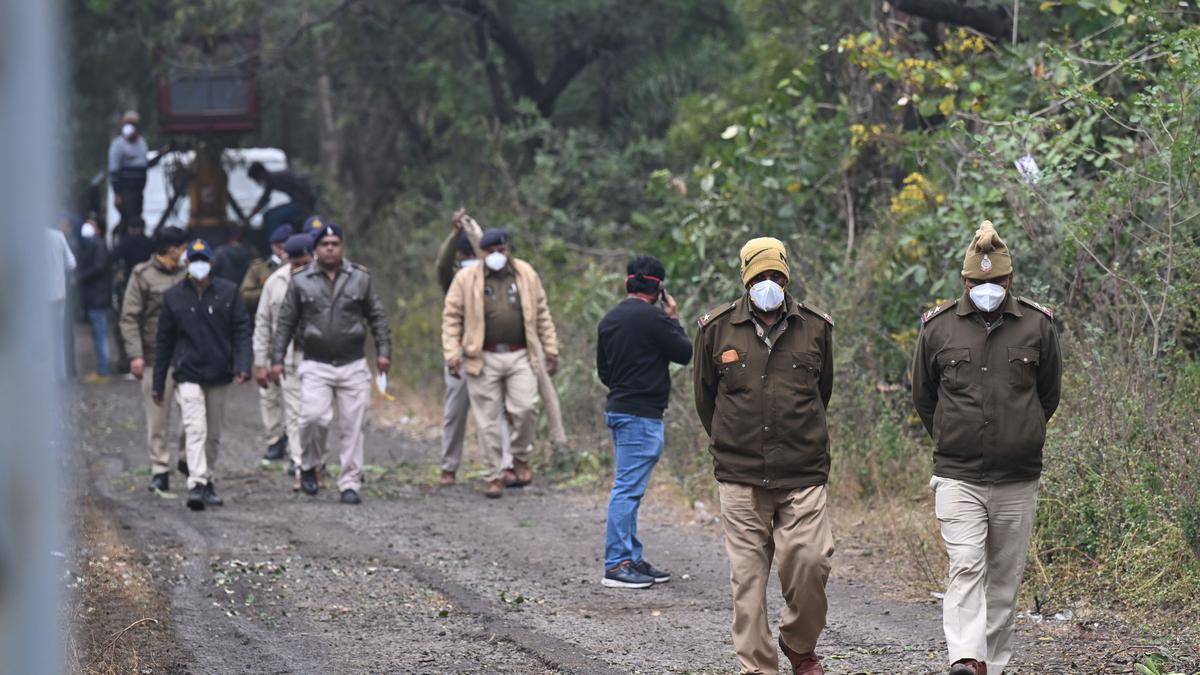
NDMA’s First-Ever Guidelines on Disaster Victim Identification (DVI)
- 06 Feb 2026
In News:
- India has taken a major institutional step in disaster governance with the release of its first national guidelines and Standard Operating Procedures (SOPs) for Disaster Victim Identification (DVI) by the National Disaster Management Authority (NDMA).
- Titled “National Disaster Management Guidelines on Comprehensive Disaster Victim Identification and Management”, the document was released on Republic Day, marking 25 years of the 2001 Gujarat earthquake, one of India’s worst mass fatality disasters.
Rationale and Context
The guidelines were necessitated by a series of mass fatality incidents in 2025, which exposed serious gaps in India’s ability to scientifically identify victims and ensure dignified management of human remains. These included:
- Air India aircraft crash, Ahmedabad
- Chemical factory explosion, Sangareddy (Telangana)
- Gambhira bridge collapse, Vadodara (Gujarat)
- Flash floods, Dharali (Uttarakhand)
- Delhi car bomb blast (near Red Fort)
In several of these incidents, victims remained unidentified or were identified after long delays, aggravating emotional trauma for families and creating legal and administrative complications. The absence of standard protocols, trained forensic manpower, and modern infrastructure highlighted the urgent need for a comprehensive national framework.
Objectives of the Guidelines
The DVI guidelines aim to:
- Ensure scientific, accurate and coordinated identification of disaster victims
- Enable dignified handling and handover of human remains
- Address forensic, logistical and institutional lacunae
- Standardise roles of multiple agencies across local, state and central levels
- Integrate humanitarian sensitivity with forensic science
Four-Stage Disaster Victim Identification Process
The guidelines prescribe a globally accepted four-stage identification protocol:
- Systematic Recovery – Careful retrieval of human remains from disaster sites
- Post-Mortem Data Collection – Collection of fingerprints, DNA, dental data and physical markers
- Ante-Mortem Data Collection – Gathering medical records, dental history and identifying features from families
- Reconciliation – Scientific matching of ante-mortem and post-mortem data before release of remains
This structured approach minimises errors, duplication, and misidentification.
Key Innovations and Forensic Advances
A landmark recommendation is the creation of a National Dental Data Registry, recognising that teeth and jaws often survive fires, explosions and decomposition, making dental records a reliable identification tool. The guidelines also formally incorporate:
- Forensic odontology (dental identification)
- Forensic archaeology, enabling identification of remains months or years after disasters, especially in landslides and buried sites
The framework draws from INTERPOL Disaster Victim Identification (DVI) standards, suitably adapted to Indian conditions.
Humanitarian Forensics Approach
The guidelines consciously move beyond a purely procedural mindset to adopt a “humanitarian forensics” approach:
- Discourages mass physical autopsies in large-scale disasters
- Emphasises cultural and religious sensitivity
- Mandates emotional support and counselling for families
- Focuses on the dignity of the dead, timely legal closure, and emotional closure for survivors
Institutional and Operational Framework
The document clearly outlines:
- Composition of DVI teams
- Coordination among police, medical, forensic, administrative and disaster-response agencies
- Command and leadership structures at multi-agency disaster sites
It realistically acknowledges challenges arising from overlapping jurisdictions and the presence of hundreds of responders during major disasters.
Challenges Highlighted
The guidelines identify multiple India-specific constraints:
- Rapid decomposition due to hot and humid climate
- Fragmentation, charring and commingling of remains
- Displacement of bodies during floods and landslides
- Severe shortage of mortuary spaces and cold-chain infrastructure
- Lack of trained forensic manpower
- Absence of reliable manifests or centralized data systems
Implementation Roadmap
NDMA has proposed:
- Establishing organisational DVI structures nationwide
- Training experts across forensic disciplines
- Creating specialised state-level DVI teams
- Fast-tracking implementation on a “war footing”
Way Forward and Value Addition
To strengthen the framework further:
- Linking Ayushman Bharat Health Account (ABHA) with optional dental or implant data can make the Dental Registry operational
- Use of digital forensics (smart devices, biometric locks, cloud health data) for rapid preliminary identification
- Deployment of portable Rapid DNA labs at disaster sites to reduce delays
- Adoption of blockchain-based chain-of-custody systems for tamper-proof forensic records
- Development of international DVI cooperation mechanisms for cross-border disasters
Conclusion
NDMA’s first-ever DVI guidelines mark a paradigm shift from ad hoc responses to an institutionalised, scientific and humane disaster response framework. By integrating advanced forensic science with ethical sensitivity and global best practices, the guidelines significantly strengthen India’s disaster governance architecture.
Their success, however, will depend on effective implementation, sustained capacity-building, and technological integration, ensuring dignity for victims and closure for families during future mass fatality events.
Operation Sagar Bandhu

- 30 Nov 2025
In News:
India has launched Operation Sagar Bandhu, a rapid Humanitarian Assistance and Disaster Relief (HADR) mission, to support Sri Lanka in the aftermath of Cyclone Ditwah, which triggered severe floods and landslides across the island nation, causing over 80 deaths and large-scale displacement.
Background and Launch
Cyclone Ditwah brought intense rainfall from mid-November, leading to riverine flooding particularly in Sri Lanka’s Western Province and widespread damage to homes and infrastructure. In response, India initiated Operation Sagar Bandhu as part of its Neighbourhood First Policy and Vision MAHASAGAR, underscoring its commitment to regional solidarity and maritime cooperation.
Relief Deployment and Coordination
The operation is coordinated by the Ministry of External Affairs, with operational support from the Indian Navy and the Indian Air Force.
- Sea-based relief: India’s aircraft carrier INS Vikrant and frontline warship INS Udaigiri reached Colombo carrying emergency supplies and HADR equipment.
- Air-based relief: An IAF C-130J transport aircraft delivered approximately 12 tonnes of humanitarian aid, including tents, tarpaulins, blankets, hygiene kits, and ready-to-eat food.
This sea–air integrated logistics ensured swift delivery to affected areas and flexibility to scale assistance as conditions evolved.
Humanitarian Impact
Sri Lanka’s Disaster Management Centre reported extensive flooding across multiple provinces, thousands of affected families, and damage to hundreds of homes. Heavy rainfall warnings exceeding 150–200 mm in several districts raised concerns of further inundation. India’s relief supplies were handed over to Sri Lankan authorities to support immediate shelter, sanitation, and food needs.
Diplomatic Significance
India’s leadership highlighted solidarity with its “closest maritime neighbour.” The mission demonstrates India’s readiness to act as a first responder in the Indian Ocean Region, reinforcing trust and cooperation during crises. It also showcases India’s growing HADR capability, combining naval reach, airlift capacity, and inter-ministerial coordination.
UN ESCAP Asia-Pacific Disaster Report 2025
- 29 Nov 2025
In News:
The UN Economic and Social Commission for Asia and the Pacific (ESCAP), in its Asia-Pacific Disaster Report 2025, has warned that Asian megacities such as Delhi, Karachi, Dhaka, Manila, Shanghai and Seoul face severe and potentially deadly heat stress due to the combined impact of global warming and the urban heat island (UHI) effect.
Urban Heat Island Effect and Temperature Rise
The report highlights that even if global warming is limited to 1.5–2°C, dense urban areas could experience an additional 2–7°C rise in local temperatures. This amplification is caused by concrete-dominated landscapes, limited green cover, waste heat from vehicles and air conditioners, and poor urban ventilation. As a result, cities heat up far beyond surrounding rural areas, pushing everyday temperatures into dangerous zones.
Heat Index and Measurement of Risk
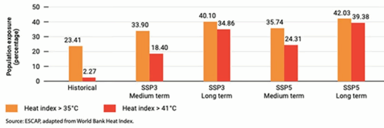
To assess extreme heat risk, ESCAP used the heat index, which combines air temperature and relative humidity to reflect “felt temperature.”
- 35°C and above: Severe heat stress
- 41°C and above: Extreme danger with high risk of heat stroke
The analysis used four thresholds-35°C, 37°C, 39°C and 41°C, corresponding to the World Bank’s heat risk index categories. South and Southwest Asia fall in the highest risk categories (3 and 4).
Regional Exposure Patterns
- India, Pakistan and Bangladesh may face over 300 days annually with heat index above 35°C, and more than 200 days above 41°C in several regions.
- Over 40% of South Asia’s population is projected to experience chronic exposure to extreme heat in both medium- and long-term scenarios, regardless of climate mitigation pathways.
- Southeast Asia could see nearly 30% of its population exposed to extreme heat under business-as-usual scenarios.
Extreme Heat: Fastest Growing Climate Hazard
The report identifies extreme heat as the fastest-growing climate-related hazard in Asia-Pacific.
- 2024 was the hottest year on record globally.
- The Bangladesh heatwave (April–May 2024) affected ~33 million people, the largest single disaster by population impacted.
- In India, prolonged heatwaves caused around 700 deaths, making it the second deadliest event in the region that year.
According to EM-DAT, over 180 natural and climate-induced disasters were recorded in Asia-Pacific in 2024.
Health, Inequality and Air Pollution Linkages
Extreme heat overwhelms the body’s thermoregulation, increasing risks of cardiovascular, respiratory and kidney disorders, as well as heatstroke. Urban poor communities are disproportionately affected due to crowded housing, lack of cooling, water stress and limited healthcare access. Heat also worsens air pollution, as droughts and wildfires increase PM10, PM2.5, VOCs and nitrogen oxides, creating a dangerous heat–pollution feedback loop.
Economic and Livelihood Impacts
Heat stress severely affects productivity in labour-intensive sectors such as agriculture, construction and industry. Across Asia-Pacific, working hours lost to heat stress are projected to more than double—from 3.75 million to over 8.1 million full-time job equivalents by 2030.
Using probabilistic risk modelling, ESCAP estimates average annual disaster losses could rise from $418 billion currently to $498 billion under high-emission scenarios, reflecting rising exposure and insufficient adaptation.
Way Forward Highlighted by the Report
The report stresses the need to place extreme heat at the centre of multi-hazard planning, including:
- Heat–health early warning systems with last-mile communication
- Heat-sensitive urban design (cool roofs, urban forests, shaded corridors)
- Legal protection for outdoor workers
- Strengthened health systems and cooling shelters
- Inclusive adaptation policies targeting vulnerable populations
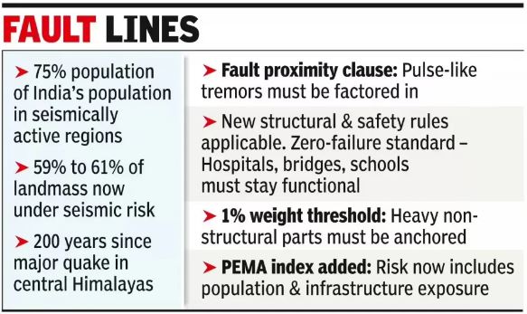
India’s Updated Seismic Zonation Map (2025)
- 28 Nov 2025
In News:
India has released an updated Seismic Zonation Map (2025) under the revised Earthquake Design Code (IS 1893), marking a major shift in the country’s approach to earthquake risk assessment and structural safety. The revision replaces the 2016 map and aligns India’s standards with contemporary scientific understanding and international best practices.
Why Was the Update Needed?
- Underestimation of Himalayan Risk: Earlier maps classified the Himalaya largely under Zones IV and V, despite the region being among the most tectonically active belts globally along the Indian–Eurasian plate boundary.
- Outdated Methodology: Previous zonation relied heavily on historical epicentres, past damage, and broad geology, overlooking evolving rupture dynamics.
- Rupture Propagation Ignored: Southward propagation of Himalayan Frontal Thrust ruptures was inadequately captured, underestimating risks in densely populated foothill towns such as Dehradun.
- Rising Exposure: Nearly three-fourths of India’s population now lives in seismically active regions, increasing disaster vulnerability.
- Global Practice Gap: The need to adopt Probabilistic Seismic Hazard Assessment (PSHA), used internationally, became imperative.
What is a Seismic Zonation Map?
A seismic zonation map divides a country into zones based on the expected intensity and frequency of earthquakes.
- Issued by the Bureau of Indian Standards (BIS)
- Integrated into IS 1893 (Earthquake Design Code)
- Forms the basis for urban planning, infrastructure design, and disaster preparedness
Key Features of the Seismic Zonation Map 2025
- Introduction of Zone VI:
- A new highest-risk zone created.
- The entire Himalayan arc from Jammu & Kashmir–Ladakh to Arunachal Pradesh, now falls under Zone VI, reflecting sustained extreme tectonic stress.
- Scientific Basis – PSHA:
- Uses Probabilistic Seismic Hazard Assessment, factoring in:
- Ground-shaking attenuation with distance
- Tectonic regime and fault behaviour
- Underlying lithology
- Uses Probabilistic Seismic Hazard Assessment, factoring in:
- Expanded High-Risk Coverage:
- 61% of India’s landmass now lies in moderate to high hazard zones (up from 59%).
- The Peninsular Plateau shows minor refinements, retaining a relatively stable seismic profile.
- Boundary Rule Enhancement: Towns located along zone boundaries will be assigned to the higher-risk zone.
- Focus on Non-Structural Safety: First-time emphasis on parapets, ceilings, overhead tanks, façade panels, lifts, electrical lines, and suspended fixtures.
- Near-Fault Provisions:
- Mandatory consideration of pulse-like ground motions near active faults.
- Updated limits on displacement, ductility, and energy dissipation.
- Site-Specific Requirements: New norms for liquefaction risk, soil flexibility, and response spectra.
- Critical Infrastructure Standards: Hospitals, schools, bridges, pipelines, and public utilities must remain functional after major earthquakes.
Implementation Challenges
- Retrofitting Existing Infrastructure: High costs, technical complexity, and coordination issues.
- Economic Impact: Stricter norms may increase construction costs.
- Technical Capacity: PSHA-based, site-specific designs require advanced geotechnical expertise and equipment.
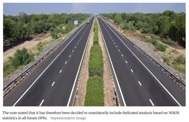
National Database for Emergency Management (NDEM)
- 16 Nov 2025
In News:
The Ministry of Road Transport and Highways (MoRTH) has made it mandatory to incorporate ISRO’s National Database for Emergency Management (NDEM) analysis in all Detailed Project Reports (DPRs) for highway construction. This marks a shift towards geospatially informed, risk-aware infrastructure planning wherein satellite-based decision support systems become integral to national development.
Key Highlights:
- NDEM is a national-level geospatial platform providing real-time, multi-temporal satellite data for disaster preparedness, mitigation, response, and infrastructure planning.
Institutional Architecture
- Developer: National Remote Sensing Centre (NRSC), ISRO
- Guidance: National Disaster Management Authority (NDMA) & Ministry of Home Affairs (MHA)
- Users: Central and State agencies, NDRF, SDRFs, SDMA, infrastructure planners
Core Functionalities
- Multi-hazard mapping (floods, earthquakes, cyclones, landslides, droughts)
- Digital Elevation Models (DEM) for terrain, slope, and drainage
- Land Use / Land Cover (LULC)
- Decision-support tools for emergency response
- Geospatial analytics for risk modelling and vulnerability assessment
Rationale Behind MoRTH’s Mandate
- Addressing Infrastructure Vulnerability: India’s highways traverse diverse geomorphological zones—floodplains, seismic zones, fragile Himalayan slopes - making them prone to natural hazards. NDEM’s geospatial datasets reduce the probability of faulty alignment, slope failure, and drainage mismanagement.
- Enhancing Project Feasibility and Efficiency: The mandate seeks to:
- Reduce field-level uncertainties
- Prevent cost overruns due to unforeseen terrain constraints
- Align infrastructure with long-term climatic and hydrological trends
- Enabling Evidence-Based Governance: By mandating NDEM analysis, MoRTHinstitutionalises:
- Data-driven DPR preparation
- Accountability in route design
- Standardisation of hazard-informed planning
Key Areas Where NDEM Strengthens Highway Planning
- Route Alignment Optimisation: NDEM helps engineers identify:
- Landslide-prone slopes
- Flood-prone lowlands
- Seismic fault lines
- Ecologically sensitive zones
- This enables selection of safer, cost-optimal corridors.
- Improved Engineering Design
- Hazard zonation supports:
- Slope stabilisation design
- Optimum bridge and culvert placement
- Scientific drainage planning
- Protection structures in vulnerable zones
- Social and Environmental Risk Reduction: NDEM layers assist in:
- Avoiding densely populated risk zones
- Minimising displacement and ecological impact
- Strengthening environmental and social screening
- Strengthening Disaster Resilience: In the context of rising climate-driven hazards, NDEM supports planning that ensures:
- Continuity of road networks during disasters
- Reduced damage to assets
- Better deployment of emergency services
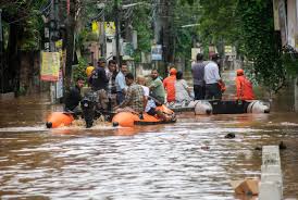
MY Bharat Aapda Mitras
- 02 Sep 2025
In News:
- In the wake of devastating floods in Punjab and Himachal Pradesh, the Union Minister of Sports and Youth Affairs, Dr. Mansukh Mandaviya, announced the deployment of over a thousand trained MY Bharat Aapda Mitras to aid ongoing rescue and relief efforts.
- The initiative underscores the government’s emphasis on community-based disaster response, leveraging trained youth volunteers to strengthen resilience at the grassroots level.
MY Bharat: An Overview
- MY Bharat is an autonomous body established by the Department of Youth Affairs, Ministry of Youth Affairs and Sports.
- It operates as a phygital (physical + digital) platform, connecting and mobilising India’s youth (aged 15–29 years) through volunteering, mentorship, experiential learning, and industry networks.
- The platform seeks to provide equitable access to opportunities, enabling youth to contribute to Viksit Bharat (Developed India).
Aapda Mitra Programme under MY Bharat
- The Aapda Mitra programme, implemented by the National Disaster Management Authority (NDMA), provides structured, NDMA-certified disaster response training to youth volunteers.
- Training modules cover:
- Search and rescue operations
- First aid and medical response
- Crowd management
- Emergency coordination
- These volunteers act as first responders, ensuring the timely supply of food, medicines, and relief material to communities cut off by floods, landslides, or cloudbursts.
Current Mobilisation for Punjab and Himachal Pradesh
- Thousands of Aapda Mitras are being deployed across the flood-hit districts of Punjab and Himachal Pradesh.
- Volunteers will work in coordination with District Magistrates, district administrations, and local authorities to ensure swift rescue and relief.
- Their role will be crucial in reaching remote villages, where connectivity has been disrupted due to floods and landslides.
Significance
- Strengthens community-led disaster resilience.
- Bridges the gap between formal institutions (NDMA, administration) and citizen response efforts.
- Provides a youth-centric model of disaster preparedness, integrating skill development with national service.
- Demonstrates the whole-of-society approach to disaster management by combining government resources, institutional training, and grassroots volunteerism.
Mission Mausam
- 02 Sep 2025
In News:
The increasing frequency of extreme weather events—cloudbursts, flash floods, and landslides—has underlined the urgent need for robust forecasting and disaster management mechanisms in India’s Himalayan region.
In this context, the Indian Meteorological Department (IMD), under the Ministry of Earth Sciences (MoES), is set to install four additional radars in Jammu & Kashmir (J&K) as part of Mission Mausam (2024). This development coincides with intensified relief and rehabilitation efforts following unprecedented rainfall and floods in August–September 2025.
Mission Mausam: An Overview
- Launched: 2024 by the Ministry of Earth Sciences.
- Implementing Agencies: IMD, National Centre for Medium-Range Weather Forecasting (NCMRWF), and Indian Institute of Tropical Meteorology (IITM).
- Objectives:
- Enhance India’s forecasting capability across short, medium, extended, and seasonal scales.
- Develop high-resolution models for improved accuracy in monsoon prediction.
- Strengthen observational networks with radars, satellites, automated weather stations.
- Provide sector-specific advisories for agriculture, water resources, health, energy, and disaster management.
- Build capacity through national and international collaborations.
Significance: It represents a transformative milestone in India’s climate resilience strategy, supporting sustainable development, while safeguarding lives, livelihoods, and infrastructure.
Relief and Rehabilitation Measures in J&K (2025)
Following the cloudbursts and floods, the Centre and UT administration launched coordinated relief measures:
- Immediate Relief: Supply of rations, medicines, water filters, and medical kits. Additional consignments dispatched from MP funds to supplement government aid.
- Community Role: Civil society and local bikers acted as first responders, showcasing a whole-of-society approach.
Broader Relevance for Disaster Management
- Policy Linkages: Aligned with the Disaster Management Act, 2005 and the Sendai Framework (2015–2030), emphasizing early warning systems and community resilience.
- Socio-Economic Impact: Strengthening forecasting reduces agricultural losses, protects infrastructure, and prevents human casualties.
- Strategic Significance: Enhances preparedness in the fragile Himalayan ecosystem, prone to climate-induced disasters.
C-FLOOD
- 06 Jul 2025
In News:
In a significant advancement in disaster risk management, Union Minister of Jal Shakti Shri C.R. Patil inaugurated C-FLOOD, a Unified Inundation Forecasting System. Developed under the National Supercomputing Mission (NSM), C-FLOOD marks a pivotal step toward strengthening India's flood preparedness and mitigation strategy.
What is C-FLOOD?
C-FLOOD is a web-based, real-time flood forecasting platform designed to deliver two-day advance inundation forecasts at village-level resolution. It provides:
- Flood inundation maps
- Water level predictions
- Localized early warnings to support disaster response and planning.
Developing Agencies:
- Centre for Development of Advanced Computing (C-DAC), Pune
- Central Water Commission (CWC)
- National Remote Sensing Centre (NRSC)
Developed in collaboration with the Ministry of Jal Shakti, Ministry of Electronics & IT (MeitY), and Department of Science & Technology (DST).
Key Features:
- 2-Day Village-Level Forecasts: Localized and high-resolution predictions up to the gram panchayat level.
- Advanced 2-D Hydrodynamic Modelling: Simulations run on High-Performance Computing (HPC) systems under NSM.
- Multi-Basin Coverage: Initially operational in the Mahanadi, Godavari, and Tapi river basins, with future expansion planned.
- Unified Data Integration: Combines outputs from national and regional flood models into one platform.
- Disaster Portal Linkage: Designed for integration with the National Disaster Management Emergency Response Portal (NDEM).
- Climate-Adaptive Governance: Supports flood forecasting in regions vulnerable to climate-induced extreme weather events.
Strategic Importance:
- Disaster Risk Reduction: Enables timely warnings, efficient evacuations, and minimizes loss of life and property.
- Scientific & Operational Integration: Bridges hydrological modelling with on-ground responses.
- Supports Viksit Bharat @2047 Vision: Contributes to climate-resilient water governance.
- Promotes Inter-Agency Synergy: Encourages coordination among CWC, C-DAC, NRSC, and disaster management bodies.
Government Directions and Future Path:
During the inauguration, the Union Minister emphasized:
- Wide dissemination of C-FLOOD to enhance public awareness.
- Expansion to all major river basins through comprehensive inundation studies.
- Improved accuracy via satellite data validation and ground-truthing.
- Integration with NDEM for real-time emergency response.
The minister lauded the collaborative spirit of CWC, C-DAC, and NRSC, and reaffirmed the government's commitment to proactive and technology-driven disaster management.
Cell Broadcast System

- 03 Jul 2025
In News:
The Department of Telecommunications (DoT), in collaboration with the National Disaster Management Authority (NDMA), is piloting a Cell Broadcast (CB) system to enhance emergency communication and deliver real-time disaster alerts across India.
What is the Cell Broadcast System?
Cell Broadcasting is a telecommunication technology that enables mobile network operators to send geographically targeted text alerts to all mobile devices in a specific area. Unlike traditional SMS, CB messages are broadcast simultaneously to all phones within a cell tower’s coverage, ensuring instant delivery even during network congestion.
Key Features and Benefits:
- Instantaneous alerts during emergencies like earthquakes, tsunamis, lightning strikes, and industrial disasters.
- Indigenously developed by the Centre for Development of Telematics (C-DOT).
- Language inclusivity: Messages can be broadcast in multiple Indian languages.
- Particularly effective in high-density areas and during network overloads.
Integration with Existing Systems:
This CB system complements the existing Integrated Alert System (SACHET), which:
- Has delivered over 6,899 crore SMS alerts.
- Covers all 36 States and Union Territories.
- Supports 19 Indian languages.
- Is based on the Common Alerting Protocol (CAP) as recommended by the International Telecommunication Union (ITU).
Once fully deployed, the Cell Broadcast system will strengthen India’s disaster preparedness, ensuring wider, faster, and more inclusive dissemination of critical alerts.
DNA Identification in Mass Fatality Events
- 17 Jun 2025
In News:
Following the tragic crash of an Air India Boeing 787 Dreamliner from Ahmedabad to London Gatwick (June 2025), authorities have initiated DNA-based identification to match the remains of victims. In mass fatality incidents where bodies are mutilated or decomposed, DNA analysis becomes the gold standard for establishing identity.
What is DNA Identification?
DNA (Deoxyribonucleic Acid) is a unique genetic code present in almost every cell of the human body, with the exception of identical twins. It is widely used in forensic science for accurate identification, particularly in disasters where visual identification is impossible.
Sample Collection and Preservation:
- DNA begins degrading post-mortem, and the rate of degradation is influenced by:
- Type of tissue (soft vs hard)
- Environmental conditions (humidity, temperature)
- Hard tissues such as bones and teeth are preferred due to better preservation against decomposition.
- Soft tissues (like skin and muscle) degrade faster and, if used, must be stored in 95% ethanol or frozen at -20°C.
- In large-scale accidents, sample collection from wreckage can take weeks or even months (e.g., 9/11 took 10 months).
Reference Samples:
To match unidentified remains, reference DNA is taken from biological relatives—preferably parents or children of the victims, who share about 50% of their DNA.
Methods of DNA Analysis:
1. Short Tandem Repeat (STR) Analysis:
- Evaluates short, repeating DNA sequences that vary among individuals.
- Requires nuclear DNA, hence not suitable if the DNA is highly degraded.
- Analysis of 15+ hyper-variable STR regions can confirm family relationships with high accuracy.
2. Mitochondrial DNA (mtDNA) Analysis:
- Used when nuclear DNA is not recoverable.
- mtDNA is inherited exclusively from the mother and is present in multiple copies per cell.
- Effective for matching with maternal relatives (e.g., mother, maternal uncles/aunts, siblings).
3. Y-Chromosome Analysis:
- Targets male-specific genetic material.
- Useful for identifying remains using DNA from paternal male relatives (father, brothers, paternal uncles).
- Helpful when direct relatives are unavailable but male-line relatives exist.
4. Single Nucleotide Polymorphisms (SNPs) Analysis:
- Suitable when DNA is highly degraded.
- Analyzes variations at single base-pair locations in DNA.
- Can also match DNA with personal items like a toothbrush or hairbrush.
- However, less accurate than STR analysis.
Significance for Disaster Management and Forensics:
- DNA-based victim identification ensures scientific accuracy, aiding in closure for families, and upholding legal and humanitarian obligations.
- Modern forensic genetics has become an essential tool in mass disaster response protocols worldwide.
Black Boxes in Aviation
- 16 Jun 2025
In News:
The tragic crash of an Air India Boeing 787-8 Dreamliner from Ahmedabad to London Gatwick on June 12, 2025, has spotlighted the critical role of black boxes—a key component in aviation safety and accident investigations. Despite their name, these devices are painted bright orange for easy visibility at crash sites.
What are Black Boxes?
Modern aircraft are equipped with two essential flight recorders:
- Cockpit Voice Recorder (CVR): Captures pilot and co-pilot conversations, ambient cockpit sounds, alarms, and radio transmissions.
- Flight Data Recorder (FDR): Records up to 25 hours of technical flight data including altitude, speed, engine parameters, flight path, and over 3,500 variables.
These devices operate continuously without interruption, storing vital information that can reconstruct the events leading up to an air crash.
Design and Durability
Black boxes are built to withstand extreme conditions:
- Casing: Made from crash-resistant materials like titanium or steel.
- Survivability: Can endure temperatures up to 1,100°C, high-impact G-forces, and remain underwater for up to 30 days.
- Locator Beacon: Emit signals to help recovery teams locate them, especially in underwater crashes.
Why Are They Called 'Black' Boxes?
The term “black box” originated from early film-based recorders stored in light-tight boxes. However, modern units are painted bright orange with reflective strips to aid visual detection after accidents.
Evolution of Flight Recorders
- 1930s: François Hussenot in France developed early photographic film-based recorders.
- 1953-54: Dr. David Warren in Australia invented the modern FDR while investigating unexplained crashes of the de Havilland Comet.
- 1960: Mandatory installation of CVRs and FDRs in commercial aircraft.
- 1965: Regulators required recorders to be painted in visible colours.
- 1990: Solid-state memory replaced magnetic tapes, increasing durability and storage capacity.
India's Aircraft Accident Investigation Bureau (AAIB), under the Ministry of Civil Aviation, oversees accident probes. In April 2025, it established a dedicated flight recorder laboratory in New Delhi to improve investigation efficiency.
Technological Advancements
- Combined Recorders: Modern systems often integrate CVR and FDR in a single unit to meet ICAO norms for extended recording.
- Deployable Recorders: Automatically ejected during a crash, float on water, and transmit their location using an Emergency Locator Transmitter (ELT).
- Satellite-Based Data Streaming: Future technologies aim to stream flight data in real time, minimizing data loss during oceanic crashes.
Black boxes serve as the backbone of aviation accident investigations by providing critical insight into aircraft performance and crew actions before a crash. Their development reflects ongoing efforts to enhance air travel safety and accountability. The Ahmedabad crash investigation led by the AAIB will heavily rely on these devices to determine the exact sequence of events and prevent future tragedies.
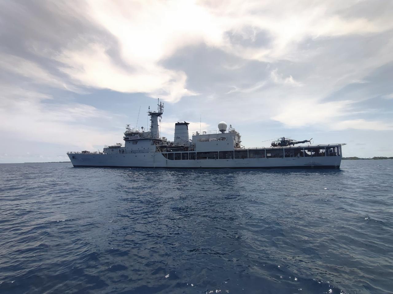
INS Sharda
- 08 May 2025
In News:
The Indian Navy’s offshore patrol vessel, INS Sharda, has reached Maafilaafushi Atoll in the Maldives to participate in its first-ever Humanitarian Assistance and Disaster Relief (HADR) exercise, scheduled from May 4 to May 10, 2025.
Strengthening Regional Maritime Cooperation and Disaster Preparedness
This exercise is a key part of India’s strategic efforts to enhance regional maritime cooperation and bolster disaster readiness within the Indian Ocean Region (IOR). It underscores India’s steadfast commitment to its “Neighbourhood First” Policy, which recognizes the Maldives as a close maritime neighbour with deep strategic and cultural ties.
Aligning with the MAHASAGAR Vision
The HADR exercise supports the recently unveiled MAHASAGAR vision—Mutual and Holistic Advancement for Security and Growth Across Regions—introduced by the Prime Minister during the Mauritius visit. MAHASAGAR reaffirms India’s role as a net security provider and first responder in the Indian Ocean, building on the earlier SAGAR doctrine (Security and Growth for All in the Region). Both frameworks emphasize inclusive security, regional cooperation, and disaster resilience.
Objectives of the HADR Exercise
According to the Indian Navy, the exercise aims to:
- Enhance interoperability between the Indian Navy and the Maldives National Defence Force (MNDF).
- Conduct joint drills focusing on Search and Rescue (SAR), disaster response coordination, logistical support, and medical aid.
- Facilitate training programs for capacity building among personnel.
- Engage with local communities to raise awareness and strengthen disaster preparedness.
This maiden HADR exercise by INS Sharda marks a significant step toward deepening India-Maldives maritime collaboration and regional disaster management capabilities.
Disaster Management (Amendment) Bill, 2024
- 27 Mar 2025
In News:
The Parliament has passed the Disaster Management (Amendment) Bill, 2024, aiming to strengthen disaster response mechanisms.
Ministry: Home Affairs
Background
The Disaster Management Act, 2005 established a three-tier structure:
- National Disaster Management Authority (NDMA)
- State Disaster Management Authorities (SDMAs)
- District Disaster Management Authorities (DDMAs)
These bodies were responsible for disaster planning, mitigation, and response at national, state, and district levels respectively.
Key Amendments
1. Preparation of Disaster Management Plans
- Earlier: Executive Committees were responsible for preparing disaster plans.
- Now: NDMA and SDMA will directly prepare and approve national and state disaster management plans.
2. Expanded Functions of NDMA and SDMA
New responsibilities include:
- Periodic risk assessments, including risks from climate-related events.
- Technical guidance to lower-level authorities.
- Minimum standards of relief recommendations.
- Creation of disaster databases containing:
- Disaster risk profiles
- Fund allocations and expenditures
- Preparedness and mitigation strategies
- NDMA-specific roles:
- Assessment of state preparedness
- Post-disaster audits to evaluate response effectiveness
3. Urban Disaster Management Authorities (UDMAs)
- To be established in state capitals and municipal corporation areas.
- Composition:
- Chairperson: Municipal Commissioner
- Vice Chairperson: District Collector
- Additional members as per state government notification
- Responsible for urban disaster planning and implementation.
4. State Disaster Response Force (SDRF)
- States are empowered to establish SDRFs for specialized disaster response.
- Functions and service conditions to be defined by state governments.
5. Statutory Status to Key Committees
- National Crisis Management Committee (NCMC):
- Nodal body for major national disasters
- Chaired by the Cabinet Secretary
- High-Level Committee (HLC):
- Sanctions financial assistance to states
- Chaired by the concerned Union Minister
6. NDMA Staffing and Appointments
- NDMA can determine the number and type of officers and staff.
- Can appoint experts and consultants with prior central government approval.
Rationale Behind the Amendment
- Climate Change: Increased frequency of extreme weather events necessitates proactive strategies.
- Decentralization Gaps: States faced implementation challenges under the 2005 Act.
- Institutional Strengthening: Clearer roles for national and sub-national bodies.
- Technology and Data Integration: Emphasis on real-time data and performance audits.
Key Concerns and Criticism
- Centralization of Power:NDMA’s enhanced role may reduce state autonomy in disaster response.
- Overlap with State Authority:Potential encroachment on state disaster planning and fund utilization.
- Delayed Relief via NDRF:Increased central oversight may slow localized relief efforts.
- Omission of Emerging Threats:Excludes disasters like heatwaves from official definitions.
- Lack of State-Specific Relief Funds:Demand for region-focused financial provisions by states like Bihar.
Way Forward
- Ensure Federal Balance: Maintain cooperation between Centre and states.
- Update Definitions: Include climate-induced disasters like heatwaves.
- Transparent Funding Mechanism: Clear protocols for fund allocation and usage.
- Empower Local Bodies: Strengthen DDMAs and UDMAs through training and resources.
- Institutional Audits: Regular post-disaster audits to enhance future readiness.
Pink Fire Retardant
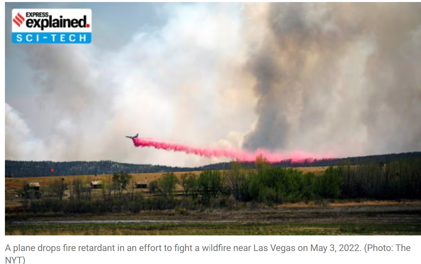
- 13 Jan 2025
In News:
As wildfires continue to rage across Southern California, authorities are deploying pink fire retardant from aircraft to help combat the blazes. Despite its widespread use, concerns over its effectiveness and environmental risks have surfaced in recent years.
What is Pink Fire Retardant?
- Fire retardant is a chemical mixture designed to slow down or extinguish wildfires. The most commonly used product in the U.S. is Phos-Chek, a brand of retardant.
- Phos-Chek primarily contains ammonium phosphate-based slurry (salts like ammonium polyphosphate), which helps the retardant stay longer and resist evaporation, unlike water.
Purpose and Visibility
- Fire retardants are sprayed ahead of fires to coat vegetation, reducing oxygen and preventing flames from spreading.
- Color is added to the fire retardant, often bright pink, to improve visibility. This ensures firefighters can track its spread and create effective fire lines, helping protect lives and property.
Manufacturer
- Perimeter Solutions manufactures Phos-Chek, which is used for aerial fire suppression efforts.
Effectiveness of Pink Fire Retardant
Limited Effectiveness
- The use of fire retardants like Phos-Chek is not always effective across different wildfire conditions.
- Aerial retardants depend on environmental conditions like terrain, slope, and weather for optimal effectiveness.
- Researchers, including Forest Service scientists, suggest that retardant effectiveness is more limited under changing climate conditions.
- Climate change is narrowing the window of opportunity for using aerial retardants, reducing their impact.
Uncertainty in Impact
- The effectiveness of fire retardants is hard to quantify. Multiple firefighting methods are used simultaneously, making it difficult to attribute wildfire suppression success solely to the retardant.
Environmental Concerns of Pink Fire Retardant
Toxicity and Pollution
- Phos-Chek contains toxic metals such as chromium and cadmium, both of which are harmful to humans and the environment.
- Chromium and cadmium are linked to serious health issues, including cancer and liver/kidney diseases.
- Aquatic life is particularly vulnerable to these toxins, as the chemicals can enter waterways, causing extensive damage to ecosystems.
Impact on Rivers and Streams
- The use of pink fire retardant has raised concerns regarding the contamination of rivers and streams.
- A study by the University of Southern California (USC) in 2024 estimated that 850,000 pounds of toxic chemicals have been released into the environment since 2009 due to fire retardant use.
Growing Use and Pollution
- From 2009 to 2021, over 440 million gallons of retardant were applied across U.S. lands.
- During this period, an estimated 400 tons of heavy metals were introduced into the environment, further exacerbating the pollution levels.
Financial and Practical Concerns
High Cost and Inefficiency
- The cost of deploying fire retardant is significant. Aerial firefighting operations require substantial resources, including planes, helicopters, and large quantities of retardant.
- Environmental experts argue that using fire retardant from planes is ineffective and expensive, especially in light of the growing environmental concerns.
Disposal of Toxic Waste from Union Carbide Factory (Bhopal)
- 07 Jan 2025
In News:
The Madhya Pradesh government has begun disposing of the 337 tonnes of toxic waste from the premises of Union Carbide India Limited (UCIL) in Bhopal, 40 years after the gas tragedy.
Key Highlights:
- Packing and Transportation:
- Waste is packed in airtight containers under the supervision of the Central Pollution Control Board (CPCB) and Madhya Pradesh Pollution Control Board (MPPCB).
- 12 specially designed airtight containers are being used for packing, and each container will be loaded onto trucks for transport.
- The waste movement will be escorted with a green corridor of about 250 kilometers.
- Incineration Process:
- The waste will undergo incineration in Pithampur, with residue stored in a two-layer membrane landfill to prevent contamination.
- A trial incineration of 10 tonnes of the waste was done in 2015 with no harmful effects, and results were submitted to the High Court.
Bhopal Gas Tragedy: A Historical Overview
- About the Tragedy:
- In 1984, a chemical leak at the Union Carbide pesticide plant released methyl isocyanate (MIC), leading to one of the worst industrial disasters in history.
- The leak was caused by a failed maintenance attempt and malfunctioning safety systems.
- Immediate effects included respiratory issues, eye problems, and abdominal pain, while long-term effects included chronic lung conditions, genetic abnormalities, and higher infant mortality rates.
- Legal and Government Response:
- In 1985, the Indian government passed the Bhopal Gas Leak Disaster Act to represent victims in legal claims.
- UCIL initially offered USD 5 million, while the Indian government demanded USD 3.3 billion. The case was settled in 1989 for USD 470 million.
- In 2010, seven Indian nationals were convicted for causing death by negligence, but were released on bail.
Hazardous Waste Management in India
- Definition and Types:
- Hazardous waste refers to waste that poses significant risks due to toxicity, reactivity, or corrosiveness.
- Common sources include chemical production, outdated technologies, and wastewater treatment.
- Regulations and Disposal Methods:
- The Environment Protection Act (1986) and the Basel Convention (1992) govern hazardous waste management in India.
- India generates about 7.66 million tonnes of hazardous waste annually, with the majority being landfillable (44.3%) and recyclable (47.2%).
- Disposal methods include incineration, co-processing in cement plants, and material/energy recovery.
- Challenges in Hazardous Waste Management:
- Inadequate treatment technologies, especially in small and medium industries.
- The need for stricter compliance with waste management laws and more efficient remediation of hazardous sites like Bhopal.
1984 Bhopal disaster
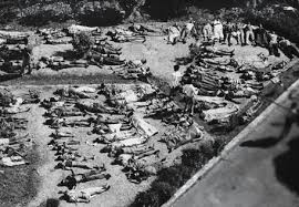
- 04 Dec 2024
In News:
Forty years after the Bhopal disaster on December 2-3, 1984, several hundred tonnes of toxic waste still remain around the ill-fated Union Carbide plant.
Overview of the incident:
The 1984 Bhopal disaster, one of the world’s worst industrial accidents, was caused by the release of methyl isocyanate (MIC) gas, which was a key component in the production of pesticides at the Union Carbide India Limited (UCIL) plant. However, the toxic legacy of the disaster extends far beyond MIC, with a range of other harmful substances lingering in the environment. These include:
- Methyl Isocyanate (MIC):Primary toxic agent: MIC is a highly toxic, volatile compound. Exposure can cause severe respiratory distress, eye irritation, pulmonary edema, and even death.
- Heavy Metals:The site of the plant is contaminated with various heavy metals, including:
- Mercury: Known to accumulate in the body and affect the nervous system, kidneys, and liver. Even small doses over time can lead to chronic health problems.
- Chromium: Exposure to high levels of chromium, particularly hexavalent chromium, is associated with lung cancer and damage to the respiratory system.
- Lead: A potent neurotoxin, lead can cause developmental delays, memory problems, and damage to the kidneys.
- Nickel: Can cause respiratory and lung cancers when inhaled in significant quantities.
- Copper: High levels of copper exposure can damage the liver and kidneys.
- Organic Compounds:Several organic chemicals were found at the site, including:
- Hexachlorobutadiene: A suspected carcinogen that can cause liver damage, kidney damage, and neurological issues upon exposure.
- Chloroform (Trichloromethane): Known for its effects on the central nervous system, exposure can lead to dizziness, loss of consciousness, and even death at high concentrations. It is also a possible carcinogen.
- Carbon Tetrachloride: A potent liver toxin, exposure can result in liver damage, cancer, and nervous system toxicity.
- Trichlorobenzene: These compounds are volatile and can spread through air and water, accumulating in fatty tissues and causing damage to organs like the liver and kidneys.
- Persistent Organic Pollutants (POPs):Some of the contaminants, particularly the organic compounds, are classified as persistent organic pollutants, which do not degrade easily in the environment. These can lead to:
- Cancer: Several of these compounds are carcinogenic.
- Neurological damage: Prolonged exposure can affect both the central and peripheral nervous systems.
- Reproductive and developmental disorders: Exposure has been linked to adverse effects on fertility and developmental health in humans.
- Environmental and Long-term Health Effects:
- Even decades later, contamination continues to affect the health of people living around the site, with high rates of cancers, birth defects, respiratory diseases, and other health issues. Water sources in the region remain unsafe due to heavy contamination with toxic chemicals. Persistent organic pollutants have been identified in local communities, indicating that the contamination continues to spread.
Asia-Oceania Meteorological Satellite Users' Conference (AOMSUC-14)

- 02 Dec 2024
In News:
The 14th Asia-Oceania Meteorological Satellite Users' Conference (AOMSUC-14)was held in New Delhi, India, hosted by the India Meteorological Department (IMD) under the Ministry of Earth Sciences. This annual event brings together meteorologists, earth scientists, and satellite data users to discuss advancements in satellite technology for weather and climate monitoring.
Key Facts:
- Objective:
- Promote Satellite Observations: Highlight the importance of satellite data for meteorology and climatology.
- Advance Remote Sensing Science: Foster advancements in satellite technology and its application in weather forecasting and climate monitoring.
- Encourage Collaboration: Facilitate dialogue between satellite operators and users to enhance the use of satellite data across the Asia-Oceania region.
- Discuss Future Plans: Update on the current status and future plans of international space programs.
- Engage Young Scientists: Encourage the involvement of young researchers in satellite science and meteorology.
- Participants:
- Around 150 participants from various countries, including key international space organizations like WMO, NASA, ESA, JAXA, and other meteorological and space entities.
- The conference will feature oral presentations, poster sessions, panel discussions, and a training workshop focused on satellite data application.
- Significance of the Conference:
- Regional Cooperation: AOMSUC promotes stronger cooperation between countries in the Asia-Oceania region, addressing shared challenges in meteorology and satellite data usage.
- Improved Forecasting: Enhances satellite data utilization for more accurate weather forecasting, disaster prediction, and climate monitoring.
- Disaster Risk Management: Strengthens early warning systems for extreme weather events, improving disaster preparedness and response.
- Capacity Building: Offers training and workshops for local meteorologists, boosting the capacity of countries to use satellite data effectively for weather forecasting and climate services.
- Data Sharing: Encourages collaboration in satellite data sharing, facilitating better access to meteorological data across national borders.
- History of AOMSUC:The first AOMSUC was held in Beijing, China in 2010. Since then, the conference has been held annually in various Asia-Oceania locations and has become a leading event for the meteorological community.
SanyuktVimochan 2024
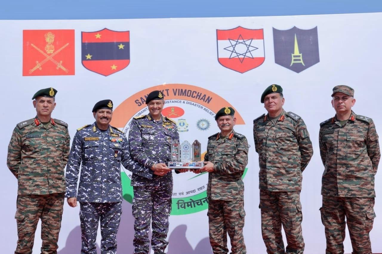
- 20 Nov 2024
In News:
Recently, the Indian Army successfully conducted the Multilateral Annual Joint Humanitarian Assistance and Disaster Relief (HADR) Exercise, 'SanyuktVimochan 2024' at Ahmedabad and Porbandar, Gujarat.
Key Highlights:
- Conducted by: Konark Corps of Southern Command, Indian Army.
- Day 1: Tabletop Exercise (TTX)
- Theme: 'Cyclone in Coastal Region of Gujarat'.
- Focused on simulating a cyclone scenario affecting the Okha-Porbandar coastline.
- Discussed disaster relief strategies and interagency cooperation to improve response readiness.
- Attended by senior officials from NDMA, Armed Forces, State Disaster Management, and industry representatives, including delegates from nine foreign countries.
- Day 2: Multi-Agency Capability Demonstration
- Held at Chowpatty Beach, Porbandar.
- Simulated Disaster Scenario: Coordinated response to a cyclone, showcasing joint operations by:
- Indian Army, Navy, Air Force, Coast Guard, NDRF, SDRF, and other Central and State agencies.
- Key actions demonstrated:
- Requisition and Surveillance: Civil administration’s request for Armed Forces' assistance, followed by area surveillance.
- Rescue Operations: Insertion of personnel to rescue casualties.
- Casualty Evacuation: Use of resources to evacuate and assist victims.
- Resuscitation and Rehabilitation: Restoration efforts for affected citizens.
- Industrial Display &Atmanirbhar Bharat Initiative:
- Showcased indigenous HADR equipment from Indian defense industries.
- Highlighted technological advancements and self-reliance in disaster management.
- SanyuktVimochan 2024 enhanced India's disaster response capabilities, ensuring a coordinated and effective approach to humanitarian assistance.
- The exercise also bolstered India’s leadership in global disaster relief, contributing to international best practices and collaborative efforts in humanitarian assistance and disaster response.