Silverpit Crater

- 16 Mar 2026
In News:
Recent scientific research has confirmed that the Silverpit Crater, located beneath the North Sea, was formed by a massive asteroid impact millions of years ago. The finding resolves a long-standing debate regarding the origin of the structure since its discovery in 2002.
About Silverpit Crater
The Silverpit Crater is a buried impact structure located beneath the seabed of the North Sea, approximately 80 miles (about 130 km) off the coast of Yorkshire in the United Kingdom.
Key Facts
- Depth: Around 700 metres beneath the seabed
- Discovery: Identified in 2002 through seismic surveys during hydrocarbon exploration
- Age of Formation: Estimated to have formed 43–46 million years ago
- Cause: Impact of a high-velocity asteroid or space rock striking the seabed
The crater remained hidden for millions of years due to thick layers of marine sediments covering the impact structure.
Scientific Evidence for Asteroid Impact
- Recent geological analysis has provided strong evidence supporting the asteroid impact hypothesis.
- Researchers identified shocked quartz and feldspar crystals in rock samples obtained from a nearby oil exploration well. These minerals form only under extreme pressure conditions generated by hypervelocity impacts, such as meteorite or asteroid collisions with Earth.
- The presence of these shock-deformed minerals is considered a key diagnostic indicator of impact events, confirming the extraterrestrial origin of the crater.
Geological Features of Silverpit Crater
The Silverpit structure displays characteristics typical of large hypervelocity impact craters.
- Crater Diameter: Approximately 3 kilometres wide
- Concentric Fault Rings: A system of circular faults extending up to 20 kilometres in diameter
- Structure: Multiple concentric rings surrounding a central crater, a feature commonly seen in large impact structures
- Shape: Nearly circular with a central peak, resembling classic meteorite impact craters
These structural features make Silverpit one of the most well-preserved buried impact craters discovered beneath the ocean floor.
Kosi River
- 06 Mar 2026
In News:
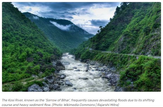
The Kosi River is a major transboundary river of the Ganga River system, flowing through China (Tibet), Nepal, and India. It is widely known as the “Sorrow of Bihar” because of its frequent and devastating floods that affect large parts of northern Bihar.
Recent observations indicate that the river has shifted its course westward by more than 100 km over the past two centuries, highlighting its highly dynamic and unstable nature.
Geographical Features and Course
- The Kosi River originates in the Himalayan region of Nepal and Tibet and flows through Nepal before entering the plains of India.
- Formation: The river is formed by the confluence of three major Himalayan streams: Sun Kosi, Arun Kosi, Tamur Kosi. These rivers originate in the Himalayan mountains and join in eastern Nepal to form the main Kosi River.
Course of the River
- The river flows through mountainous terrain in Nepal and receives several tributaries.
- About 48 km north of the India–Nepal border, it passes through the Chatra Gorge in the Siwalik Hills.
- After emerging from the hills, it enters the alluvial plains of Bihar in northern India.
- Finally, it joins the Ganges River south of Purnea after travelling approximately 724 km.
Drainage Basin
- The Kosi basin covers an area of about 74,500 sq km, of which only around 11,070 sq km lies within India. Most of the catchment area lies in Nepal and the Himalayan region, which strongly influences the river’s hydrology.
- The basin’s sandy and fertile soils support agriculture, particularly the cultivation of maize (corn).
Major Tributaries
- The Kosi river system consists of seven major tributaries, which are collectively known as the Sapta Kosi (Seven Kosis): Sun Kosi, Tama Kosi (Tamba Kosi), Dudh Kosi, Indravati, Likhu, Arun, Tamur (Tamor)
- These tributaries drain large parts of the Himalayan watershed, contributing significant water and sediment to the river.
Why is the Kosi Called the “Sorrow of Bihar”?
Frequent Flooding: The Kosi River is notorious for severe floods in northern Bihar, causing large-scale damage to: agriculture, infrastructure, and settlements.
Heavy Sediment Load: The river carries large amounts of silt and sediment from the young and fragile Himalayan mountains. During the monsoon season, this sediment deposition raises the riverbed, increasing the likelihood of flooding.
Shifting Course: One of the most striking features of the river is its frequent change in course.
- Over the last 200–250 years, the river has shifted more than 100 km from east to west across the plains of Bihar.
- This phenomenon creates new floodplains while abandoning older channels.
Challenges Associated with the Kosi River
The dynamic nature of the Kosi poses several challenges:
- Recurring floods and displacement of populations
- Damage to agriculture and infrastructure
- Riverbank erosion and channel migration
- Transboundary water management issues between India and Nepal
Efforts such as embankment construction and flood-control projects have been implemented, but managing the river remains difficult due to its high sediment load and unstable course.
Salar de Pajonales
- 03 Mar 2026
In News:
Recent scientific research in Chile’s Salar de Pajonales has revealed that gypsum deposits can act as microscopic shields, protecting living microbes and preserving ancient fossils. The findings hold major implications for astrobiology and the ongoing search for life on Mars, as similar mineral formations exist on the Martian surface.
Geographical and Environmental Profile
Salar de Pajonales is a large playa (salt flat) located in northern Chile on the western margin of the Altiplano-Puna plateau, at an elevation of approximately 3,500 metres above sea level. It is the third-largest salar in the Atacama Region, after Salar de Atacama and Salar de Punta Negra.
The region lies within the hyper-arid core of the Atacama Desert, one of the driest places on Earth.
Polyextreme Conditions
The site experiences polyextreme environmental conditions, including:
- Extreme aridity
- High altitude and low atmospheric pressure
- Intense solar and ultraviolet radiation
- Large diurnal temperature variations
- Sulfate-rich mineral composition
These characteristics closely resemble surface conditions on Mars, making the region a significant Martian analogue site.
Hydrological and Geological Features
Salar de Pajonales is an endorheic basin (a closed drainage system with no outflow), sustained primarily by groundwater inputs.
The surface is dominated by evaporitic deposits, particularly:
- Gypsum (calcium sulfate dihydrate) crusts
- Layered microbial structures known as stromatolites
These mineral and biological structures provide a natural laboratory to study life under extreme conditions.
Gypsum as a Microbial Shield
Recent studies have demonstrated that gypsum acts as a microscopic protective barrier.
Key Findings
- Active extremophile communities: Halophilic bacteria and archaea survive within protected microhabitats inside gypsum crystals.
- Preserved fossilized microbes
- Ancient microbial remains and molecular biosignatures are trapped within gypsum layers.
- Some biosignatures date back thousands of years.
- Radiation and Desiccation Protection
- Gypsum shields biological material from ultraviolet radiation.
- It prevents rapid dehydration in hyper-arid conditions.
Thus, gypsum serves as a natural repository of biosignatures, preserving evidence of life even in extreme environments.
Astrobiological Significance
The environmental conditions in Salar de Pajonales mirror those believed to have existed on early Mars. Importantly, gypsum has also been detected on Mars by orbital and rover missions.
The study suggests that:
- Future Mars missions should prioritize gypsum-rich terrains.
- Orbiters and rovers can target sulfate deposits as prime candidates for detecting ancient life.
- Mineralogical mapping can guide astrobiological exploration strategies.
This research strengthens the hypothesis that if microbial life ever existed on Mars, its traces may be preserved within evaporitic minerals like gypsum.
Total Lunar Eclipse
- 02 Mar 2026
In News:
A total lunar eclipse is scheduled on 3 March 2026 (12 Phalguna 1947 Saka Era), offering a rare celestial spectacle visible from large parts of the globe including most regions of India. This astronomical event holds significance for both scientific observation and cultural discourse, coinciding with the traditional period of Holi festivities in North India.
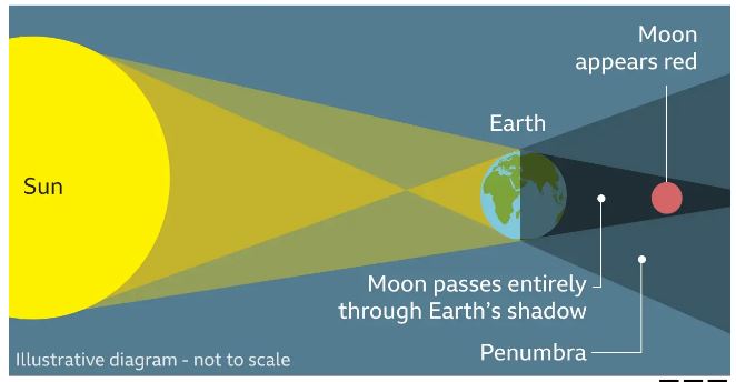
What is a Lunar Eclipse?
A lunar eclipse occurs when the Earth positions itself directly between the Sun and the Moon during the full Moon phase, such that the Earth’s shadow falls on the Moon. This alignment (known as syzygy) results in the Moon entering Earth’s shadow and becoming darkened.
The Earth’s shadow comprises two parts:
- Umbra – The central, darker region where the Sun’s rays are completely blocked.
- Penumbra – The outer, lighter region where sunlight is only partially obstructed.
Depending on how the Moon traverses these shadow zones, eclipses are categorised as:
- Penumbral Eclipse – Moon passes through the penumbra only; very subtle.
- Partial Eclipse – Part of the Moon enters the umbra.
- Total Eclipse – The whole lunar disk enters Earth’s umbra and undergoes complete darkening.
When totality occurs, the Moon often acquires a reddish or coppery hue — popularly known as the “Blood Moon” — due to Rayleigh scattering of sunlight in Earth’s atmosphere. Shorter wavelengths (blue/green light) scatter out, while longer red wavelengths bend into the shadowed region and illuminate the Moon indirectly.
Why Does the Moon Turn Red?
During totality, the Moon’s direct sunlight is completely blocked by the Earth. However, Earth’s atmosphere refracts sunlight, bending the longer red wavelengths into the umbra and onto the lunar surface. This indirect illumination produces the distinctive red or copper hue of the Moon during the peak eclipse phase. This optical effect is the same reason why sunrises and sunsets appear red on Earth.
Cultural and Observational Relevance
- Cultural Context: The eclipse occurs just a day before the festival of Holi in some regional calendars, creating conversations around tradition, auspiciousness, and ritual observances such as Sutak period (a traditional eclipse-related phase affecting religious practices).
- Scientific Observation: Since the entire sequence spans several hours and involves the full transition through penumbral and umbral shadows, it provides valuable opportunities for both amateur and professional astronomers to study Earth’s atmospheric effects and lunar motion.
- Public Skywatching: Skywatching events and public outreach programmes, such as planetarium viewings, encourage scientific literacy and appreciation of astronomy among students and the general public.
India’s First Underwater Road-cum-Rail Tunnel under the Brahmaputra

- 17 Feb 2026
In News:
The Cabinet Committee on Economic Affairs (CCEA) has approved the construction of India’s first underwater twin-tube road-cum-rail tunnel beneath the Brahmaputra River in Assam at a total capital cost of ?18,662 crore. The 33.7 km access-controlled greenfield corridor, including a 15.79 km underwater tunnel, marks a milestone in India’s infrastructure engineering and is expected to significantly enhance connectivity across the Northeast.
Project Overview
What the Project Entails
- Total Length: 33.7 km
- Underwater Twin-Tube Tunnel: 15.79 km beneath the Brahmaputra
- Corridor: Gohpur (NH-15) to Numaligarh (NH-715)
- Development Mode: Engineering, Procurement and Construction (EPC)
- Total Capital Cost: ?18,662 crore
- Civil Cost: ?11,982.36 crore
- Land Acquisition: ?716.65 crore
The project integrates road and rail infrastructure, making it India’s first underwater road-cum-rail tunnel and only the second such structure globally.
Key Engineering Features
- Twin-Tube Design: Two parallel tubes ensure traffic segregation, safety redundancy, and efficient emergency evacuation systems. One tube will also incorporate railway infrastructure.
- Access-Controlled Greenfield Corridor: A four-lane highway designed for high-speed, uninterrupted travel.
- Multi-Modal Integration:
- Connects NH-15 and NH-715
- Integrates with Rangia–Mukongselek and Furkating–Mariani railway sections under Northeast Frontier Railway
- Links 4 major railway stations, 2 airports (Holongi and Tezpur), and 2 inland waterway terminals
- Traffic and Logistics Impact:
- Reduces distance from 240 km to 34 km
- Cuts travel time from 6 hours to 20 minutes
- Estimated AADT (FY-25): 4,680 PCUs
About the Brahmaputra River
The Brahmaputra is one of Asia’s largest rivers, originating from the Chemayungdung Glacier near Lake Mapam in Tibet (~5,300 m). Known as Yarlung Tsangpo in Tibet, Siang/Dihang in Arunachal Pradesh, and Jamuna in Bangladesh, it flows through China, India, and Bangladesh.
- Length: ~2,900 km
- Among the world’s highest average river discharges
- Forms the world’s largest delta with the Ganga
- Characterised by highly braided channels in Assam
Constructing an underwater tunnel beneath such a dynamic and sediment-laden river demonstrates advanced tunnelling and geotechnical capability.
Regional and Strategic Significance
1. Boost to Northeast Connectivity: Though located in Assam, the project benefits Arunachal Pradesh, Nagaland, and the wider Northeast region, improving passenger and freight mobility.
2. Economic Multiplier Effects
- Connects 11 economic nodes, including industrial areas and logistics hubs.
- Facilitates faster freight movement and reduces logistics costs.
- Expected to generate 80 lakh person-days of employment (direct and indirect).
3. Tourism and Social Connectivity
- Enhances access to Kaziranga National Park and Deopahar Archaeological Site.
- Connects aspirational districts like Udalguri and Darrang and tribal district Dima Hasao.
4. Strategic and Border Importance: Improves connectivity to Arunachal Pradesh, strengthening infrastructure in border areas and enhancing national security preparedness.
Pamir–Karakoram Anomaly

- 22 Dec 2025
In News:
Scientists are currently analysingdeep ice cores extracted from the Kon-Chukurbashi ice cap in Tajikistan to scientifically explain the Pamir–Karakoram anomaly, a rare glaciological phenomenon where glaciers have remained stable or even gained mass since the late 20th century, contrary to global trends of glacier retreat.
What is the Pamir–Karakoram Anomaly?
The Pamir–Karakoram anomaly describes the near-stability or slight expansion of glaciers in the Karakoram Range and parts of the Pamir Mountains, while glaciers in most other mountain systems, such as the Himalayas, Alps, Andes, and Rockieshave been rapidly shrinking due to rising global temperatures.
Geographical Extent
- Core region: Karakoram Range (notably Gilgit-Baltistan and parts of Ladakh)
- Extended region: Western Pamirs (Tajikistan and Afghanistan)
- This region lies at the junction of major mountain systems-Hindu Kush, Pamirs, Kunlun, and Himalayas.
Proposed Explanations
Several interacting factors are believed to contribute to this anomaly:
- Increased winter precipitation: Heavy snowfall during winters replenishes glacier mass and compensates for summer melting.
- Dominance of Western Disturbances: Unlike most of the Himalayas, this region receives moisture mainly from Western Disturbances rather than the Indian monsoon.
- High-altitude, steep topography: Promotes large accumulation zones and reduces exposure to solar radiation.
- Summer cloud cover: Limits incoming solar radiation, reducing melt rates.
- Debris-covered glaciers: Rock and sediment layers insulate underlying ice, slowing melting at lower elevations.
Recent Scientific Findings
- Satellite-based studies using ICESat-2 (altimetry) and GRACE (gravity data) suggest that the anomaly has weakened in recent years.
- However, field-based ice-core analysiswhich provides long-term climate records through trapped air bubbles, isotopes, and impuritiesis still underway and may offer deeper insights into historical snowfall and temperature patterns.
Significance for India
- Glaciers in the Karakoram are a major source of the Indus River system.
- Their relative stability ensures more reliable river flows into Ladakh and Jammu & Kashmir, supporting agriculture, hydropower, and water security.
- Understanding this anomaly is crucial for climate modelling, water-resource planning, and disaster risk assessment in the western Himalayas.
Karakoram Range: Key Facts
- Location: Central Asia; spans Afghanistan, China, India, Pakistan, and Tajikistan.
- Highest Peak:K2 (8,611 m), the world’s second-highest peak after Mount Everest.
- Known for extensive glaciation and some of the largest valley glaciers outside polar regions.
Doppler Weather Radar (DWR)
- 22 Dec 2025
In News:
The Government of India has informed Parliament that 47 Doppler Weather Radars (DWRs) are currently operational across the country, covering nearly 87% of India’s geographical area. These radars play a crucial role in monitoring weather systems and improving forecasts of extreme weather events, significantly strengthening India’s disaster preparedness and early warning capabilities.
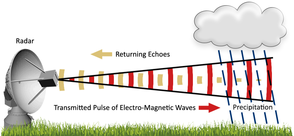
What is a Doppler Weather Radar?
A Doppler Weather Radar is an advanced meteorological instrument that uses the Doppler effect—identified by Christian Doppler—to determine both the position and velocity of atmospheric targets such as raindrops, snowflakes, or hailstones. The Doppler effect explains how the frequency of a wave changes relative to the motion of the source or observer (similar to the changing pitch of a passing train whistle).
Unlike conventional radars that only detect the location of precipitation, DWRs can also measure movement, enabling more accurate tracking of storms and cloud systems.
How Doppler Weather Radars Work
- The radar emits pulses of radio waves from an antenna.
- When these waves strike atmospheric particles, a portion of the energy is scattered back to the radar.
- The time taken for the signal to return helps calculate the distance of precipitation.
- The change in frequency or phase of the returned signal (Doppler shift) reveals the speed and direction of movement of weather systems.
- Larger particles reflect more energy, allowing estimation of rainfall intensity.
Radar Bands Used in India
The India Meteorological Department (IMD) employs different radar frequency bands based on application:
- S-band: Long-range surveillance and cyclone monitoring
- C-band: Widely used for cyclone tracking and regional weather observation
- X-band: Short-range, high-resolution detection of thunderstorms and lightning
Applications of Doppler Weather Radars
- Detection of precipitation: Rain, snow, hail
- Tracking movement of clouds and storms
- Estimation of rainfall intensity and distribution
- Nowcasting: Short-term forecasts of extreme events like cloudbursts, thunderstorms, squalls, and cyclones
- Coverage: Each radar can monitor weather within a radius of about 500 km
Mud Volcanoes
- 13 Feb 2026
In News:
Mud volcanoes are non-igneous “sedimentary volcanoes” formed in young oil-field regions, where methane and hydrocarbons under compactional stress force mud and gases to the surface.
A recent eruption of a mud volcano in Diglipur, Andaman Islands, has drawn attention to this rare geological phenomenon. Mud volcanoes differ fundamentally from magmatic volcanoes as they do not involve molten lava but are driven by sedimentary and hydrocarbon processes.
What is a Mud Volcano?
Mud volcanoes, also called sedimentary volcanoes or gas-oil volcanoes are surface expressions of subsurface pressure systems associated with hydrocarbon-rich sedimentary basins.
Key Characteristics
- Non-igneous in origin (no magma involved).
- Occur mainly in young oil-field regions with soft, unconsolidated sediments.
- Erupt mud, water, methane and other gases instead of lava.
- Often form cone-shaped structures.
- Can release flames if methane ignites.
- May emit hot mud and steam due to deep compactional heat.
Though different in origin, their eruptive behaviour can resemble magmatic volcanoes in intensity.
Formation Mechanism
Mud volcanoes develop due to:
- Compactional Stress
- Deep sediment layers experience pressure over time.
- Methane and hydrocarbons accumulate in porous formations.
- Gas Build-up and Upward Migration
- Trapped gases mix with mud and water.
- The pressurized mixture forces its way upward through fractures.
- Surface Eruption
- Mud and gases erupt, forming a cone.
- Repeated eruptions may enlarge the structure.
Due to the depth of origin, expelled mud is sometimes warm and accompanied by steam clouds.
Global Distribution
- Around 1,000 mud volcanoes have been identified globally on land and in shallow waters.
- Prominent concentrations occur in:
- Azerbaijan (Caspian region)
- Indonesia
- Mediterranean region
- Many also occur on the ocean floor, forming islands, banks, and altering coastal geomorphology.
Mud Volcanoes in India
In India, mud volcanoes are confined to the Andaman and Nicobar Islands.
Major Locations
- Baratang Island – Known site of India’s mud volcano.
- Diglipur – Recent eruption reported after several years of dormancy.
These eruptions are linked to the tectonically active Andaman subduction zone, where sediment compression and hydrocarbon accumulation occur.
Geological Significance
- Indicator of hydrocarbon-rich sedimentary basins.
- Provide insights into subsurface gas migration and petroleum systems.
- Important for understanding:
- Methane emissions (climate relevance)
- Coastal geomorphology changes
- Seismic and tectonic processes in subduction zones
Differences: Mud Volcano vs Magmatic Volcano
|
Feature |
Mud Volcano |
Magmatic Volcano |
|
Origin |
Sedimentary |
Igneous |
|
Material Ejected |
Mud, water, gases |
Lava, ash, pyroclasts |
|
Energy Source |
Gas pressure |
Magma pressure |
|
Temperature |
Relatively lower |
Extremely high |
Geminid Meteor Shower

- 17 Dec 2025
In News:
The Geminids are one of the brightest and most reliable annual meteor showers, peaking every year in mid-December.
Origin of the Name
- The meteor shower is named after the constellation Gemini, from where the meteors appear to radiate. This apparent point of origin is called the radiant. However, the constellation is only the direction in the sky - not the actual source of the meteors.
Time of Occurrence
- The Geminids occur every year in December, with peak visibility typically during the late-night and pre-dawn hours, when the radiant rises higher in the sky.
Parent Body – A Rare Case
- A unique scientific feature of the Geminids is their origin. Most meteor showers are produced by comet debris, but the Geminids originate from an asteroid called 3200 Phaethon. This makes the Geminids one of the very few major meteor showers linked to an asteroid rather than a comet.
Meteor Characteristics
- Geminid meteors are known for being bright and relatively slow-moving, which makes them easier to spot. They often produce multi-colored streaks in the sky due to the presence of different minerals that burn at different temperatures.
Understanding Meteors
- Meteors are caused by small space particles entering Earth’s atmosphere at very high speeds.
- A meteoroid is a small rocky or metallic object traveling in space. When it enters Earth’s atmosphere and burns due to friction, it produces a streak of light known as a meteor. If any part of it survives the journey and reaches the ground, it is called a meteorite.
- Meteor showers occur when Earth passes through trails of dust and debris left behind by comets or asteroids. These particles collide with the atmosphere and burn up, creating the visible streaks of light.
Why the Geminids Stand Out
The Geminids are considered special because they are linked to an asteroid instead of a comet, they produce a high number of bright meteors, and they are known for their consistent annual activity. Their slower speed compared to many comet-based meteor showers makes them especially visible and spectacular.
Sudden Stratospheric Warming (SSW)
- 12 Dec 2025
In News:
Meteorologists have recently warned of a potential Sudden Stratospheric Warming (SSW) event, which may cause below-average temperatures across parts of the United States and other mid-latitude regions later this month.
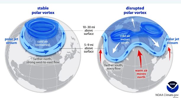
What is Sudden Stratospheric Warming?
- Sudden Stratospheric Warming (SSW) is a phenomenon marked by a rapid increase in stratospheric temperatures, sometimes by 30–50°C within a few days.
- It results in the weakening, displacement, or splitting of the polar vortex, a cold air system usually confined to the polar regions.
Mechanism of SSW
- SSW events are triggered by large-scale atmospheric (Rossby) waves generated in the troposphere.
- These waves propagate upward into the stratosphere and break over the polar vortex, similar to ocean waves.
- If sufficiently strong:
- The westerly winds of the polar vortex weaken or reverse to easterlies
- The vortex loses its circular symmetry
- This causes descending air to warm adiabatically, leading to sudden temperature rise in the stratosphere.
Impact of SSW
- The weakened or split polar vortex allows cold Arctic air to spill southward into the mid-latitudes.
- This can result in:
- Cold waves
- Severe winter weather
- Below-normal temperatures over regions such as:
- North America
- Europe
- Asia
Polar Vortex: Key Features
- A large, persistent low-pressure system containing cold air around both poles.
- Extends from:
- Tropopause
- Through the stratosphere
- Up to the mesosphere (above ~50 km)
- Seasonal behavior:
- Stronger in winter
- Weaker in summer
- During winter, it can expand and interact with the jet stream, pushing cold air southward.
Role of Jet Streams
- Jet streams are narrow bands of strong winds located in the upper troposphere (~9–12 km altitude).
- They act as a conduit for polar air outbreaks during polar vortex disturbances.
- Such interactions are common during Northern Hemisphere winters.
Afar Region
- 09 Dec 2025
In News:
Scientists studying tectonic activity in Africa suggest that the Afar region of northeastern Ethiopia may eventually evolve into a new ocean basin as the African continent slowly splits apart. This geological transformation is expected to unfold over 5–10 million years.
Location and Physical Features
The Afar region lies in northeastern Ethiopia, near where the Red Sea meets the Gulf of Aden. It includes the Afar (Danakil) Depression, one of the hottest and lowest places on Earth.
Key physical features include:
- Desert scrubland and saline lakes
- Chains of active volcanoes
- Deep rift valleys and crustal fissures
- The Awash River Valley in the southern part of the region
The landscape reflects intense tectonic forces shaping the Earth’s crust.
Tectonic Significance
The Afar region is globally important because it lies at a triple junction where three tectonic rift systems meet:
- Red Sea Rift
- Gulf of Aden Rift
- East African Rift (Main Ethiopian Rift)
This triple junction marks a point where the African Plate is gradually pulling apart, and Arabia has already separated from Africa in the past through seafloor spreading.
Continental Break-up in Progress
The East African Rift system stretches nearly 6,000 km (around 4,000 miles) from the Middle East down to Mozambique. In the Afar region, the crust is:
- Thinning
- Stretching
- Fracturing
This process is similar to the early stages of ocean formation seen in the Red Sea. Over millions of years, the rift may widen enough for seawater to flood in, creating a new ocean basin and splitting eastern Africa from the rest of the continent.
Scientists compare this process to a “zipper opening” from northeast to south.
Geological Evidence
Researchers have used magnetic data collected during airborne surveys in the late 1960s, recently reanalysed using modern techniques. These magnetic signatures in the crust record past reversals of Earth’s magnetic field, acting like geological barcodes.
The data confirm:
- Seafloor spreading between Africa and Arabia millions of years ago
- Ongoing crustal stretching in Afar
- A gradual transition from continental crust to oceanic crust
Current estimates suggest the rift is widening at a rate of 5–16 millimetres per year in some sections.
Scientific Importance
The Afar region offers a rare opportunity to observe continental break-up in real time, a process that usually takes place deep under oceans and is difficult to study directly.
It helps scientists understand:
- Formation of new oceans
- Evolution of tectonic plates
- Relationship between volcanism, earthquakes, and rifting
Anthropological Significance
Apart from geology, Afar is also famous for early human evolution discoveries. The fossil “Lucy” (Australopithecus afarensis) was discovered here in 1974, making the region crucial for paleoanthropology.
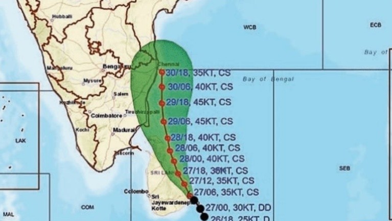
Cyclone Ditwah and Cyclone Senyar
- 29 Nov 2025
In News:
Two tropical cyclonic systems, Cyclone Ditwah and Cyclone Senyar, developed almost simultaneously over the Bay of Bengal–Andaman Sea region, drawing attention to the heightened cyclogenesis during the retreating phase of the Southwest Monsoon (October–November). The India Meteorological Department (IMD) has issued alerts for India’s east coast due to associated heavy rainfall and wind impacts.
Cyclone Ditwah: Key Facts
- Nature: Tropical cyclonic storm
- Area of formation: Southwest Bay of Bengal
- Development: Rapid intensification from a depression to a cyclonic storm in less than 24 hours
- Movement & impact: Moving towards the coasts of Tamil Nadu, Puducherry and southern Andhra Pradesh, with heavy rainfall and gusty winds expected
- Naming: Ditwah is the recommended name by Yemen
Cyclone Senyar: Key Facts
- Nature: Cyclonic system originating from a low-pressure area
- Area of formation: Near Malaysia/Strait of Malacca, over the South Andaman Sea and adjoining Bay of Bengal
- Development: Intensified into a depression and further strengthened before weakening over the Strait of Malacca
- Impact: Though it weakened, its remnant circulation and moisture feed triggered very heavy rainfall over parts of the Andaman & Nicobar Islands and South India
- Naming: Senyar is the recommended name by the UAE
Why are cyclones frequent in the Bay of Bengal During the Retreating Monsoon?
- Warm Sea Surface Temperatures (SSTs): Post-monsoon SSTs of ~28–30°C or higher provide abundant latent heat for cyclone formation.
- High Moisture Content: Strong moisture inflow from the equatorial Indian Ocean and the Bay creates a deep, humid troposphere, favouring convection.
- Southward Shift of ITCZ: During monsoon withdrawal, the Inter-Tropical Convergence Zone (ITCZ) and monsoon trough move southward over the Bay, enhancing convergence and vorticity.
- Low Vertical Wind Shear: October–early November typically sees reduced wind shear over the Bay, allowing systems to organise and intensify.
- Re-intensification of Monsoon Lows: Remnant lows/depressions moving back over warm Bay waters can re-strengthen into cyclones.
- Bay vs Arabian Sea Contrast: The Bay’s semi-enclosed nature, large river freshwater inflows (e.g., Ganga–Brahmaputra), and warmer, stratified surface waters make it more cyclone-prone than the Arabian Sea in this season.
Regional Implications
- East Coast Vulnerability: Tamil Nadu, Puducherry and Andhra Pradesh face risks of heavy rain, flooding and wind damage.
- Island Territories: The Andaman & Nicobar Islands are particularly susceptible to rainfall bursts from systems forming near the Andaman Sea.
- Hydro-meteorological Risk: Back-to-back systems can compound impacts through soil saturation, runoff and riverine flooding.
Hayli Gubbi Volcano
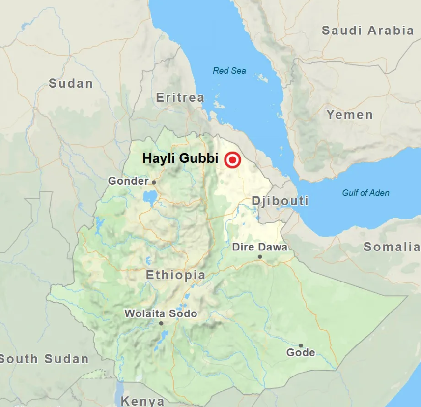
- 27 Nov 2025
In News:
A long-dormant volcano, Hayli Gubbi, in Ethiopia erupted after nearly 12,000 years, releasing massive ash plumes that travelled across the Red Sea towards Yemen, Oman, and even parts of South Asia, including India. The ash cloud led to airspace disruptions and flight diversions, highlighting the transboundary impact of large volcanic eruptions.
Geographical & Tectonic Setting
- Location: Hayli Gubbi volcano lies in Ethiopia’s Afar region, about 800 km northeast of Addis Ababa.
- It is part of the Afar Depression (Danakil Depression), one of the most geologically active regions on Earth.
- The region marks the triple junction of three tectonic plates:
- African (Nubian) Plate
- Somalian Plate
- Arabian Plate
- It forms a critical segment of the East African Rift System (EARS), where the African Plate is splitting into the Nubian (western) and Somalian (eastern) plates.
Volcanism
- Volcanism refers to the process by which magma, gases, and ash escape from Earth’s interior through vents or fissures.
Process of Eruption:
- The asthenosphere (a weak, semi-molten layer in the upper mantle) allows magma to accumulate.
- Buoyant magma rises through cracks in the lithosphere.
- As pressure decreases near the surface, dissolved gases (water vapour, CO?, sulphur gases) expand violently, triggering eruptions.
- When magma reaches the surface, it is called lava (basaltic, andesitic, or rhyolitic depending on composition).
Eruption Products:
- Lava
- Ash and dust
- Pyroclastic debris and volcanic bombs
- Gases (sulphur compounds, nitrogen compounds, CO?, etc.)
Fujiwhara Effect
- 27 Nov 2025
In News:
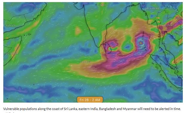
Meteorological agencies are closely monitoring the possible formation of two cyclonic systems in the Bay of Bengal, with global forecast models indicating a rare Fujiwhara-type interaction between them. Such an interaction can significantly increase uncertainty regarding cyclone track, intensity, and landfall, putting large coastal populations of South and Southeast Asia on alert.
Current Meteorological Situation
- The India Meteorological Department (IMD) has identified a well-marked low-pressure area over Malaysia and the adjoining Straits of Malacca, likely to move west-northwestwards.
- This system is expected to intensify into a depression over the South Andaman Sea, and further strengthen into a cyclonic storm over the southern Bay of Bengal within 48 hours thereafter.
- Simultaneously, an upper air cyclonic circulation over the Comorin region may induce another low-pressure area over the southwest Bay of Bengal and Sri Lanka, with potential to intensify further.
Divergence in Global Forecast Models
- Forecasts from the Global Forecast System (GFS) and the European Centre for Medium-Range Weather Forecasting (ECMWF) show significant differences in predicting the formation, interaction, track, and intensity of these systems.
- One scenario suggests the storms may interact and move together, potentially strengthening one system at the expense of the other, while another scenario shows divergent tracks, including possible movement along India’s eastern coast or towards Myanmar.
Fujiwhara Effect:
- Definition: A rare meteorological phenomenon where two nearby cyclonic systems rotate around a common centre due to interaction of their wind circulations.
- Origin: Identified by Sakuhei Fujiwhara (1921).
- Conditions Favoring Occurrence:
- Distance between cyclones usually less than ~1,400 km
- Same rotational direction (counter-clockwise in the Northern Hemisphere)
- Sea Surface Temperature >26°C
- Low vertical wind shear
Possible Outcomes of Fujiwhara Interaction
- Energy Transfer: One cyclone may intensify by drawing energy and moisture from the other.
- Merger: The two systems may fuse into a single, stronger cyclone.
- Deflection: Cyclones may push each other onto altered or diverging paths.
- Weakening: Competition for heat and moisture may weaken one or both systems.
- Stalling: Reduced movement speed can lead to prolonged rainfall over affected regions.
Implications for India and the Region
- Forecast Challenges: Track and intensity prediction becomes difficult, complicating early warning and disaster preparedness.
- Heavy Rainfall Risk: Prolonged rainfall over eastern India, Sri Lanka, Bangladesh, and Myanmar, increasing flood and landslide risk.
- Cyclone Intensification: Sudden strengthening may enhance threats from strong winds, storm surge, and coastal damage.
Semeru Volcano
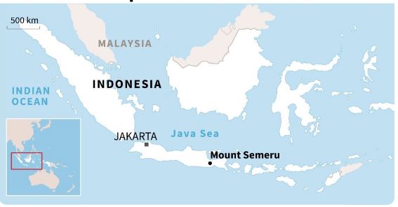
- 23 Nov 2025
In News:
Indonesia’s Semeru Volcano on Java Island erupted recently, ejecting massive ash and gas plumes up to ~13 km into the atmosphere, triggering the highest alert level, evacuations of nearby villagers, and safety advisories restricting activity around the crater.
About Semeru Volcano
- Location: East Java, Indonesia; ~310 km west of Bali
- Elevation: ~3,676 m (12,060 ft) -highest peak on Java
- Tectonic Setting: Part of the Pacific Ring of Fire, a zone of intense volcanic and seismic activity due to plate convergence
- Volcanic System: Lies at the southern end of a volcanic massif extending north to the Tengger caldera
- Summit Morphology: Complex, with crater positions having shifted NW–SE over time
- Local Name:Mahameru
Eruptive Characteristics
- Among Indonesia’s most active volcanoes
- Known for frequent ash explosions at short intervals (often every 10–30 minutes)
- Recent eruption involved pyroclastic flows (hot mixtures of gas, ash, and volcanic fragments)
- Seismicity: Elevated before and during eruptive phases
Recent Eruption – Key Facts
- Ash Plume Height: Up to ~13 km
- Alert & Safety: Highest alert declared; 8 km exclusion zone around the crater advised
- Human Impact: Preventive evacuations (hundreds relocated to temporary shelters); no immediate casualties reported
- Aviation: Monitoring in place; Bali airport operations initially unaffected
Sakurajima Volcano
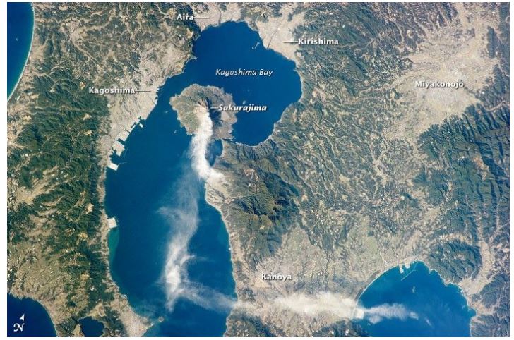
- 20 Nov 2025
In News:
Sakurajima, one of the most active volcanoes of Japan, erupted multiple times recently, sending ash and smoke plumes up to 4.4 km into the atmosphere. The eruption led to ashfall-related disruptions, including cancellation of flights at Kagoshima Airport. This was the first eruption in nearly 13 months to send ash above 4 km.
Location & Geological Setting
- Located on the southern tip of Kyushu, near Kagoshima
- Lies at the southern edge of the Aira Caldera
- Situated on a convergent plate margin, associated with subduction-related volcanism
Type & Structure
- Stratovolcano: Built from alternating layers of lava and ash
- Andesitic volcano:
- Magma is highly viscous
- High gas content, making eruptions potentially explosive
- Composed mainly of two central cones:
- Kitadake (north peak)
- Minamidake (south peak)
Eruptive History
- Among the most active volcanoes in Japan, with frequent eruptions of varying intensity
- 1914 eruption:
- One of Japan’s most powerful eruptions
- Lava flows filled the strait, connecting Sakurajima island to the mainland peninsula
- 2019 eruption: Ash plume rose up to 5.5 km
- Recent eruptions monitored by the Japan Meteorological Agency, which also warned of ashfall in Kagoshima and nearby Miyazaki region
Associated Impacts
- Ashfall affecting aviation, transport and daily life
- Recurrent eruptions make Sakurajima a key site for volcanic hazard monitoring and disaster preparedness
What is a Volcano?
- A volcano is an opening in the Earth’s crust through which magma, gases and ash escape
- Eruptions may be:
- Explosive (ash columns, pyroclasts)
- Effusive (lava flows)
- Duration can range from days to years
Ambaji Marble

- 18 Nov 2025
In News:
Ambaji Marble, a high-quality white marble quarried in Gujarat, has recently been awarded the Geographical Indication (GI) tag, recognising its uniqueness, regional authenticity, and commercial value. The GI status provides legal protection to producers in the Ambaji region and helps preserve the heritage and branding associated with this premium stone.
Origin and Location
- Named after Ambaji, a town in Banaskantha district, Gujarat.
- Quarried predominantly in the Arasur Hills of the Aravalli range.
- Known historically for its use in religious and monumental architecture.
Characteristics of Ambaji Marble
Appearance
- Milky white colour, often considered among the purest shades of natural marble.
- Displays subtle grey or beige veining, formed by natural mineral impurities during crystallisation.
- Smooth texture and uniform structure make it desirable for fine architectural work.
Durability
- Noted for its long-lasting shine and high resistance to weathering.
- Its dense crystalline structure enhances its strength and longevity.
Applications
Ambaji Marble is widely used in:
- Temples and religious structures- prominently in the Ambaji Temple itself
- Memorials and monuments
- High-end flooring and interior décor
- Architectural sculptures and carvings
Its aesthetic appeal and durability make it a preferred material for cultural and heritage buildings.
Geological Background – Understanding Marble
Marble is a metamorphic rock formed from limestone under conditions of high heat and pressure.
Composition
- Primarily composed of calcite (CaCO?)
- May contain:Clay minerals, Quartz, Micas, Pyrite, Iron oxides, Graphite
These impurities contribute to veining patterns and variations in colour.
Formation Process
- During regional metamorphism at convergent plate boundaries, limestone recrystallises into a mass of interlocking calcite crystals, producing marble.
- Dolomitic marble forms when dolostone undergoes similar metamorphic conditions.
- Marble can also form via contact metamorphism, where heat from an intrusive magma body alters adjacent limestone deposits.
Significance of the GI Tag
The GI recognition of Ambaji Marble is important because it:
- Protects the unique identity of the stone
- Ensures economic benefits for local quarrying communities
- Helps prevent market dilution by inferior substitutes
- Promotes tourism and heritage conservation in the Ambaji region
Uturuncu Volcano
- 18 Nov 2025
In News:
A recent scientific study has provided deeper insights into the unusual activity of the Uturuncu Volcano in southwestern Bolivia. Although its surface shows persistent uplift and subsidence, new seismic imaging confirms that these motions are driven by hot fluids and gases moving beneath the crater rather than rising magma, indicating a low likelihood of imminent eruption. This has earned Uturuncu the nickname of a “zombie volcano”appearing restless but not actually preparing to erupt.
Location and Geological Profile
- Country: Bolivia
- Region: Southwestern Andes Mountains
- Type:Stratovolcano, dominated by dacitic lava domes and flows
- Elevation: Approx. 6,008 m (19,711 ft) tallest mountain in southern Bolivia
- Eruption History: Last erupted ~250,000 years ago
- Current Activity: Hundreds of small earthquakes annually and persistent ground deformation
Underlying Magma and Fluid System
- Uturuncu sits above the Altiplano-Puna Magma Body (APMB), a massive crustal reservoir located 10–20 km below the surface.
- APMB spans nearly 200 km, making it the largest known active magma body in Earth’s crust.
- Seismic imaging indicates ~25% partial melt in places, acting as a deep heat and fluid source for Uturuncu.
The “Sombrero” Uplift Pattern
The volcano displays a unique deformation pattern where:
- The center uplifts, while
- The surrounding region subsides,creating a “sombrero-like” shape over a 70–93 km area.
This deformation is gradual-about 0.4 inches per year-and has persisted for at least five decades, monitored through GPS, satellite radar, and leveling surveys.
Key Findings from the Recent Study
The latest imagingusing data from over 1,700 small earthquakesreveals:
1. Fluid Movement, Not Magma Rise
- Hot supercritical fluids (with both liquid and gas characteristics) rise through a narrow conduit.
- They accumulate beneath the crater, while brines seep outward through fractured rock.
- This fluid distribution explains why the summit uplifts and the edges sink.
2. Seismic Tomography Techniques Used
Researchers used:
- Vp/Vs ratios (compressional vs. shear wave speeds) — high sensitivity to fluids
- Azimuthal anisotropy — identifying crack alignments and fluid pathways
- Low resistivity zones — tracing conductive, hot, salty fluids
These tools revealed a vertical fluid conduit feeding a shallow reservoir under the summit.
3. Eruption Risk Assessment
- No evidence of a shallow, melt-rich magma chamber
- Low gas saturation in the shallow system
- Deformation driven mostly by fluids, not magma
Thus, probability of eruption is currently low despite ongoing seismicity.
Why Uturuncu Matters
Understanding Uturuncu helps refine risk assessments for “restless” volcanoes worldwide that show signs of deformation but lack eruptible magma. This is crucial for communities near:
- Remote Andean mining regions
- Settlements along the Altiplano Plateau
- Other global volcanoes with similar gas-driven unrest
The study aids hazard planning without unnecessary alarm, preventing misinterpretation of harmless gas plumes or small quakes as eruption warnings.
Axial Seamount
- 02 Nov 2025
In News:
The Axial Seamount, an active underwater volcano located in the northeast Pacific Ocean off the coast of Oregon (USA), has shown increased seismic activity, prompting scientists to warn of a possible eruption in the near future. Despite the alert, experts emphasize that any eruption would pose no threat to coastal populations due to the volcano’s great depth.
Location & Geological Setting
- Located ~300 miles off the Oregon coast in the Pacific Ocean.
- Situated on the Juan de Fuca Ridge, a divergent boundary between the Pacific Plate and the Juan de Fuca Plate.
- Classified as a shield volcano with a summit caldera.
- Rises to a depth of approx. 1,400 m (≈4,900 ft) below sea level.
- Formed by a hotspot, where mantle plumes rise beneath the oceanic crust.
Scientific Importance
- Considered the most active submarine volcano in the northeast Pacific.
- Documented eruptions: 1998, 2011, 2015.
- The 2015 eruption triggered:
- ~8,000 earthquakes
- 400-ft-thick lava flows
- Seafloor subsidence of nearly 8 ft
Current Activity
- Recent USGS-recorded quakes of M4.8 and M5.4 occurred close to Axial Seamount.
- Over 2,000 micro-earthquakes in a single day were noted this year.
- Scientists expect the next eruption between late 2025 and early 2026, though the timing remains unpredictable.
- Surface uplift has been observed, matching levels seen prior to the 2015 eruption.
Hydrothermal Vent Ecosystem
- Hosts hydrothermal vents, releasing super-heated, mineral-rich fluids.
- Supports unique chemosynthetic ecosystems, including:
- Microbes using volcanic gases for energy
- Giant tubeworms
- Crabs, clams, fish, octopuses
- Provides a natural laboratory for studying extreme environments and deep-sea biodiversity.
Monitoring Infrastructure
- Part of the Ocean Observatories Initiative (OOI).
- Hosts the New Millennium Observatory (NeMO) — the world’s first underwater volcanic observatory.
- Real-time monitoring via undersea cables transmitting continuous data on:
- Seismic activity
- Gas emissions
- Vent temperatures
- Seafloor deformation
Hazards & Human Impact
- Despite increased activity, eruptions do not threaten humans or coastal infrastructure.
- Events occur deep underwater and may pass unnoticed at the surface.
- However, they are crucial for advancing scientific understanding of:
- Mid-ocean ridge volcanism
- Crustal formation
- Seafloor hydrothermal systems
Cyclone Montha
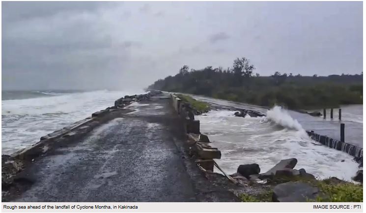
- 30 Oct 2025
In News:
- Cyclone Montha, a tropical cyclonic system that formed over the southeast Bay of Bengal in late October 2025, has emerged as one of the most significant weather events of the year for India’s eastern coastal states.
- The India Meteorological Department (IMD) has issued high-level warnings for Andhra Pradesh, Odisha, Tamil Nadu, and coastal Telangana as the system intensifies and advances toward landfall.
Formation and Meteorological Characteristics
- Cyclone Montha originated from a well-marked low-pressure area over the southeast Bay of Bengal around 24 October 2025.
- Under favourable atmospheric and oceanic conditions—warm sea surface temperatures above 28°C, high moisture availability, and low vertical wind shear—the system progressed from a depression to a deep depression by 26 October and further strengthened into a cyclonic storm. The IMD projected that it could intensify into a Severe Cyclonic Storm (SCS) before landfall.
- As of 27 October 2025, the storm was positioned approximately 350 km southeast of Kakinada, moving in a north-northwest direction at nearly 14 km/h.
- The IMD forecast predicted landfall between Machilipatnam and Kalingapatnam, near Kakinada, on the evening or night of 28 October. Wind speed estimates indicated gusts reaching 110 km/h, accompanied by “very rough to high” sea conditions and potential storm surge up to 1 metre.
Naming Mechanism and Regional Cyclone Governance
- “Montha” is a name contributed by Thailand to the World Meteorological Organization (WMO)/ESCAP Panel on Tropical Cyclones.
- Cyclone naming in the North Indian Ocean is overseen by a 13-member regional committee comprising India, Bangladesh, Pakistan, Sri Lanka, Myanmar, Maldives, Oman, Yemen, Qatar, Iran, UAE, Saudi Arabia, and Thailand.
- Each country submits suggested names, which are then assigned sequentially to future cyclones. This system enhances communication, public awareness, and clarity during simultaneous storm events.
Geographical Spread and Affected Regions
- While Andhra Pradesh remains the primary zone of impact—especially districts such as Kakinada, Konaseema, West Godavari, Krishna, Bapatla, Prakasam and Nellore—its effects range wider. Odisha has alerted 30 districts, Tamil Nadu has issued orange and yellow alerts for coastal belts, and Telangana is preparing for secondary rainfall impacts.
- Rayalaseema is also vulnerable due to the forecast of extremely heavy rainfall (>210 mm in 24 hours), increasing the risk of flash floods and landslides. Fisherfolk in all three major maritime states—Tamil Nadu, Andhra Pradesh, and Odisha—have been advised against venturing into the sea due to high waves and strong winds.
Expected Impacts
- Heavy to Extremely Heavy Rainfall: Isolated areas in coastal Andhra Pradesh and south Odisha may witness rainfall ≥21 cm in 24 hours, leading to flooding of rivers, drains, and agricultural fields.
- Strong Winds: Sustained winds of 90–100 km/h and gusts up to 110 km/h can uproot trees, damage kutcha houses, and disrupt electricity and telecom infrastructure.
- Storm Surge: Low-lying coastal pockets face inundation risks due to a possible storm surge of around 1 metre above the astronomical tide.
- Marine Hazards: Fishing vessels have been anchored, with over 900 boats already guided ashore. High swell waves and turbulent sea conditions threaten coastal ecosystems and livelihoods.
- Extended Weather Effects: Secondary effects may be felt in Telangana, Chhattisgarh, and even parts of West Bengal through rainfall, thunderstorms, and transportation disruptions.
Government Response and Preparedness Measures
State and central agencies have activated a coordinated disaster-response framework. Key measures include:
- Activation of emergency control rooms and pre-deployment of NDRF, SDRF, Coast Guard, and Army teams.
- Closure of schools in high-risk districts until 31 October.
- Stockpiling of essential commodities and readying PDS distribution systems.
- Evacuation of vulnerable populations including pregnant women and residents of low-lying areas.
- Temporary shelters being prepared with sanitation and food facilities.
- Suspension of fishing activities along the entire east coast stretch under threat.
- Continuous IMD bulletins issued for public safety instructions.
Inter-state cooperation has been emphasised, particularly between Odisha, Andhra Pradesh, and Tamil Nadu, to strengthen response logistics.
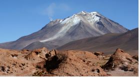
Taftan Volcano
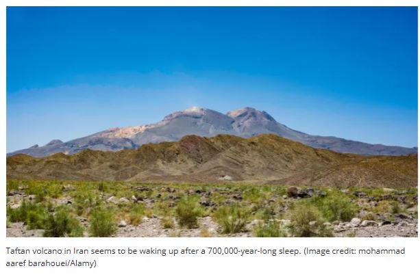
- 18 Oct 2025
In News:
A recent scientific study has revealed renewed geological activity at Mount Taftan, a stratovolcano in southeastern Iran, raising concerns among volcanologists and regional authorities. The volcano, believed to have remained inactive for nearly 700,000 years, has exhibited ground uplift and increased gas emissions, suggesting possible magmatic or hydrothermal movement beneath the surface.
Key Findings from Recent Study
- Research published in Geophysical Research Letters notes that ground near Taftan’s summit rose by ~9 cm between July 2023 and May 2024.
- Persistent uplift signals buildup of gas pressure below the volcano.
- Residents reported strong sulfurous fumes, detectable up to 50 km away in the city of Khash.
- Satellite monitoring (ESA’s Sentinel-1) indicated activity in absence of ground-based GPS stations.
Scientists stress there is no immediate eruption threat, but the volcano should be reclassified from "extinct" to dormant and monitored more closely due to increasing activity.
About Taftan Volcano
- Location: Southeastern Iran, ~56 km from Pakistan border
- Elevation:3,940 m (12,927 ft)
- Type: Semi-active stratovolcano (composite volcano)
- Volcanic Arc: Only active volcano in the Makran subduction zone
- Geological Setting: Formed due to subduction of Arabian oceanic crust beneath Eurasian plate
- Key Features: Two summits — Narkuh and Matherkuh
- Activity Indicators:
- Active hydrothermal system
- Sulfur-emitting vents (fumaroles)
- No recorded eruptions in human history
What is a Stratovolcano?
- Tall, steep-sided cone-shaped volcano
- Commonly found along convergent plate boundaries
- Composed of alternating lava flows and pyroclastic deposits
- Eruptions tend to be explosive due to viscous magma (andesite/dacite)
- Examples: Mt. Fuji, Mt. St. Helens, Vesuvius, Krakatoa
Mig La Pass
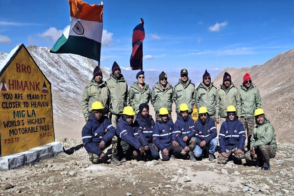
- 09 Oct 2025
In News:
The Border Roads Organisation (BRO), through Project Himank, has constructed the world’s highest motorable road at Mig La Pass in Ladakh, situated at 19,400 feet above sea level, surpassing the previous record held by Umling La (19,024 ft) in 2021. This achievement highlights India’s engineering capability and strategic preparedness in high-altitude border areas.
About Mig La Pass
- Location: Changthang Plateau, Ladakh.
- Altitude: 19,400 ft, making it the highest motorable road in the world.
- Strategic Significance:
- Connects Likaru–Mig La–Fukche, forming a third vital corridor from Hanle to Fukche, near the Indo-China border.
- Enhances logistical and military mobility, strengthening access to forward areas close to the Line of Actual Control (LAC).
- Engineering Features:
- All-weather road capable of withstanding harsh winters, shifting glaciers, and low oxygen conditions.
- Designed for continuous vehicular movement, critical for both military and civilian access.
- Tourism Potential: Provides panoramic views of the Indus Valley, potentially boosting local tourism.
Project Himank
- Established: 4 December 1985 at Leh, to develop road communication in Ladakh’s challenging terrain.
- Operational Scope: Works in high-altitude regions with short working seasons and extreme climatic conditions.
- Contributions:
- Supports the Indian Army in operations, logistics, and connectivity.
- Ensures maintenance of key routes, including the Leh-Manali and Zojila axes.
- Executes landslide and avalanche clearance, bridge construction, and snow removal.
- Aids in restoring road communication and opening airfields in remote areas.
- Engineering Excellence: Demonstrates BRO’s capability to construct durable infrastructure under extreme terrain, low oxygen, and sub-zero temperatures.
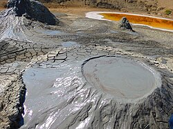
Baratang Island
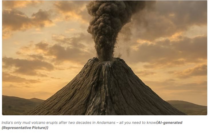
- 08 Oct 2025
In News:
India’s only mud volcano, located at Baratang Island in the Andaman and Nicobar Islands, has erupted again after more than two decades.
About Baratang Island
- Location:Baratang Island lies in the North and Middle Andaman district, approximately 150 km from Port Blair.
- Geological Uniqueness: It is home to India’s only known mud volcanoes, making it a prominent site for geological study and eco-tourism.
- Tribal Presence: The region is also inhabited by the Jarawa tribe, one of the indigenous groups of the Andaman and Nicobar Islands.
- Previous Activity: The last major eruption occurred in 2005, which was attributed to seismic activity and oceanic tectonic movements in the region.
What are Mud Volcanoes?
- Definition: Mud volcanoes, also known as “mud domes,” are geological structures formed by the eruption of mud slurries, gases, and water rather than molten rock.
- Formation Process:
- They occur when gases (mainly methane, with traces of carbon dioxide or nitrogen), generated from the decay of organic matter deep underground, force a mixture of mud and water to the surface.
- This process creates cone-shaped mounds or domes resembling typical volcanoes, but without lava.
- Characteristics:
- Their temperature is much lower than that of igneous volcanoes.
- They can range from a few meters to several hundred meters in height and up to 10 km in width.
- Some mud volcanoes also exist underwater, influencing seabed topography and occasionally forming new landforms or islands.
Comparison with Barren Island Volcano
- Barren Island, another volcanic site in the Andaman region, witnessed minor eruptions in September 2025—on the 13th and 20th.
- It is located about 140 km northeast of Port Blair and is India’s only active volcanic island, lying at the junction of the Indian and Burmese tectonic plates.
- Historical records show eruptions at Barren Island in 1787, 1991, 2005, 2017, and 2022.
- Officials have clarified that the Baratang mud volcano and the Barren Island volcano are distinct geological entities—the former being sedimentary and gas-driven, while the latter is igneous and magma-driven.
Significance and Precautions
- The Baratang eruption underscores the geological dynamism of the Andaman and Nicobar region, which lies in a seismically active zone due to the subduction of the Indian Plate beneath the Burmese Plate.
- Tourism and Safety: The site is a popular tourist attraction, but safety protocols have been enforced to prevent accidents.
- Scientific Importance: Such eruptions provide valuable insights into subsurface gas activity, tectonic movement, and geothermal processes in the region.
Cyclone Shakhti
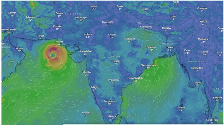
- 07 Oct 2025
In News:
Recently, the India Meteorological Department (IMD) confirmed the formation of Cyclone Shakhti over the northeast Arabian Sea. Named by Sri Lanka under the World Meteorological Organisation’s regional naming system, Shakhti is a tropical cyclonic storm forming approximately 340 km west of Dwarka, Gujarat.
Formation and Track:
The cyclone developed due to low-pressure systems over the warm Arabian Sea waters in early October 2025. IMD reports indicate:
- Shakhti intensified into a Cyclonic Storm (CS) on 3 October and was forecasted to become a Severe Cyclonic Storm (SCS) by 4 October.
- Initially moving west-northwest, it is likely to track west-southwest, reaching central parts of the north and adjoining central Arabian Sea by 5 October.
- A subsequent recurvature is expected, moving east-northeastward from 6 October.
Significance:
The occurrence of Cyclone Shakhti highlights the increasing cyclonic activity in the Arabian Sea, historically less active than the Bay of Bengal. Warmer sea surface temperatures have led to the rapid intensification of recent cyclones, including Tauktae (2021) and Biparjoy (2023), off India’s west coast.
Comparative Context:
- The Bay of Bengal experiences more cyclones due to semi-enclosed waters retaining warmth (29–30°C), abundant moisture from rivers and monsoon flows, and low-pressure pulses from Pacific typhoons.
- In contrast, the Arabian Sea is cooler, influenced by dry winds from Oman and Yemen, and lacks such external triggers, which traditionally limited cyclone intensity.
- Rising temperatures, however, are changing this pattern, making the Arabian Sea increasingly prone to severe cyclones.
Phytosaur fossil
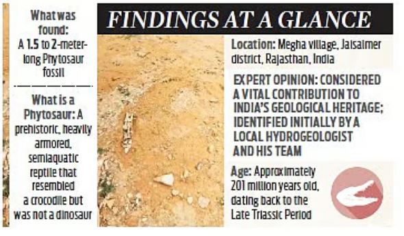
- 27 Sep 2025
In News:
Recent paleontological excavations in Megha village, Fatehgarh subdivision, Jaisalmer district, Rajasthan, have uncovered fossilised remains that may belong to a Phytosaur, a large, extinct semi-aquatic reptile. This discovery has generated significant excitement in the scientific community and reinforces Jaisalmer’s reputation as a paleontological hotspot.
About Phytosaurs
Phytosaurs are extinct reptiles of the order Phytosauria, resembling modern crocodiles, which thrived during the Late Triassic to Early Jurassic period. They displayed morphological diversity, including:
- Long-snouted forms (primarily fish-eating)
- Short-snouted forms (adapted for terrestrial prey)
- High-snouted forms (generalist feeders)
Phytosaur fossils have been reported in India, Europe, North America, Brazil, Morocco, Thailand, and Madagascar, highlighting their wide distribution and evolutionary significance.
Significance of the Find
The Megha village fossil adds to Jaisalmer’s growing list of paleontological finds, which includes dinosaur footprints, shark fossils, and marine remains. Experts suggest that the site may contain additional hidden fossils, which could provide crucial insights into:
- The evolution of prehistoric reptiles
- Convergent evolution with modern crocodilians
- Jurassic-era biodiversity and climate in India
If confirmed as a Phytosaur, the fossil will enhance our understanding of prehistoric fauna in the Indian subcontinent and strengthen the region’s global paleontological significance.
Super Typhoon Ragasa
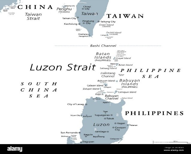
- 26 Sep 2025
In News:
Super Typhoon Ragasa—locally known as Nando—has emerged as one of the most powerful storms to strike Southeast Asia in recent years. With sustained winds exceeding 200 km/h and gusts up to 250 km/h, it has prompted large-scale shutdowns across the Philippines and Hong Kong, highlighting the region’s vulnerability to climate-induced extreme weather events.
About Super Typhoon Ragasa
- Category: 5 (the highest on the Saffir-Simpson scale)
- Wind Speed: Sustained winds of around 205 km/h, gusting up to 250 km/h.
- Origin: Formed over the western Pacific Ocean, where warm sea surface temperatures and low wind shear facilitated rapid intensification.
- Track: Moving northwestward across the Luzon Strait, impacting the Babuyan Islands in northern Philippines before heading toward southern China, including Hong Kong.
Regional and Environmental Significance
- The increasing intensity of storms like Ragasa reflects the broader pattern of climate change-driven extreme weather in the western Pacific region.
- Rising sea surface temperatures and shifting atmospheric circulation patterns have led to more frequent and severe typhoons, posing long-term challenges to disaster preparedness and coastal infrastructure resilience in densely populated regions like Luzon and Hong Kong.
Way Forward
- Strengthening Early Warning Systems: Enhanced forecasting and community-based alert dissemination can save lives in coastal and island regions.
- Climate Adaptation Infrastructure: Investment in storm-resilient housing, flood barriers, and sustainable urban planning is critical for mitigating recurring damage.
- Regional Cooperation: Shared meteorological data and coordinated disaster response among ASEAN nations, China, and Pacific island states can improve resilience.
Gulf of Finland
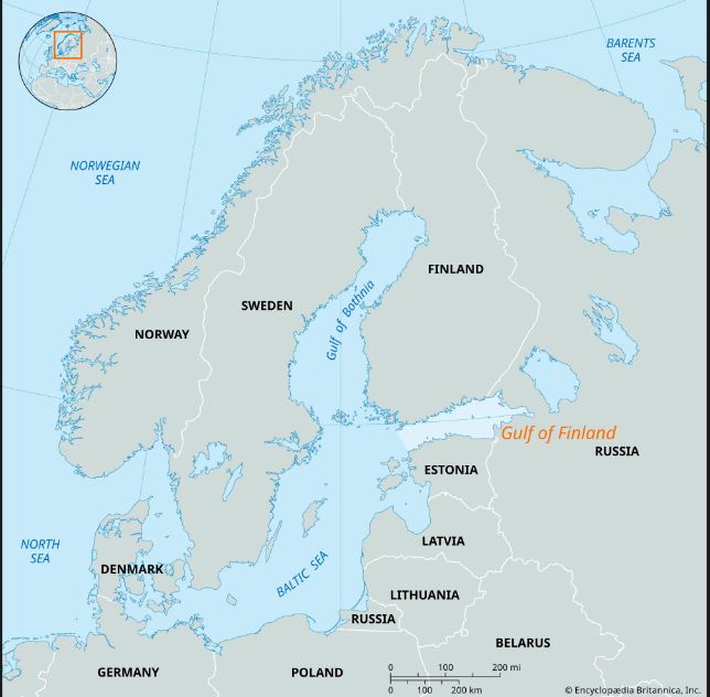
- 21 Sep 2025
In News:
Estonia recently accused Russia of violating its airspace when three Russian MiG-31 fighter jets entered Estonian airspace over the Gulf of Finland, remaining there for approximately 12 minutes. The incident has heightened tensions between NATO and Russia, as Estonia is a NATO member and takes airspace security seriously in the strategically sensitive region.
About the Gulf of Finland
- Geography: The Gulf of Finland is the easternmost extension of the Baltic Sea, covering an area of 30,000 sq.km. It stretches 400 km from east to west and 19–130 km from north to south.
- Borders:
- North: Finland (including the capital, Helsinki)
- South: Estonia (including the capital, Tallinn)
- East: Russia (including St. Petersburg at the eastern tip)
- Physical Features:
- Average depth: 38 m
- Brackish water with low salinity (~6 ppt)
- Freezes over 3–5 months in winter
- Receives inflows from the Neva and Narva rivers and the Saimaa Canal
- Contains numerous banks, skerries, and islands, including Kotlin Island (Kronstadt), Beryozovye Islands, Lisiy Island, MalyVysotsky Island, among others.
- Climate: Humid continental, characterized by hot summers and relatively harsh winters.
Strategic Significance
The Gulf of Finland is strategically vital due to its location at the eastern edge of the Baltic Sea, proximity to major cities such as Helsinki, Tallinn, and St. Petersburg, and its role as a maritime and military corridor. The airspace and naval routes over the gulf are closely monitored by NATO and Russia, making any unauthorized incursion a serious geopolitical concern.
Implications
- For Estonia: The violation underscores the need for heightened air defense readiness along its borders.
- For NATO: The incident exemplifies the ongoing airspace tensions with Russia, reflecting broader geopolitical frictions in Northern Europe.
- For Russia: Demonstrates strategic airpower projection and interest in asserting influence over the Baltic region.
Carlsberg RidgeRegion
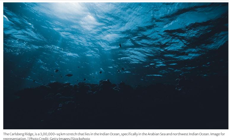
- 19 Sep 2025
In News:
India has secured an exploration contract from the International Seabed Authority (ISA) to explore polymetallic sulphide deposits in the Carlsberg Ridge region of the north-western Indian Ocean. The agreement marks a major step in India’s pursuit of deep-sea resource development and its broader vision under the Deep Ocean Mission.
About the Agreement
- The exploration contract grants India the right to survey and explore an area of approximately 3,00,000 square kilometres in the Carlsberg Ridge, a tectonically active region rich in polymetallic sulphides — deposits containing valuable metals such as copper, zinc, gold, silver, and rare elements.
- The International Seabed Authority (ISA), an autonomous body under the United Nations Convention on the Law of the Sea (UNCLOS), regulates mineral exploration and exploitation activities in international seabed areas beyond national jurisdictions.
- This licence enhances India’s presence in seabed resource exploration, complementing its earlier exploration area for polymetallic nodules in the Central Indian Ocean Basin.
About Carlsberg Ridge
- The Carlsberg Ridge is a mid-oceanic ridge — a divergent plate boundary — located in the western Indian Ocean.
- It extends from the triple junction of the African, Indian, and Australian plates, connecting to the Mid-Indian Ridge, and runs northwest toward the Gulf of Aden.
- The ridge acts as a tectonic boundary between the Somali Plate and the Indian Plate.
- Geographical features:
- Lies at an average depth of 6,000–12,000 feet (1,800–3,600 m) below sea level.
- Rises about 7,000 feet (≈2,100 m) above the surrounding seafloor.
- Extends westward near Socotra Island, eventually linking with the East African Rift System via the Gulf of Aden.
- It is one of the most prominent mid-ocean ridge systems in the Indian Ocean, characterized by frequent seismic activity and hydrothermal vents, which are potential sources of metal-rich sulphide minerals.
Significance of the Exploration
- Strategic Resource Security:Polymetallic sulphides contain economically vital metals like copper, zinc, gold, and silver, essential for clean energy technologies, electronics, and strategic industries.
- Technological Advancement:The project supports India’s Deep Ocean Mission, fostering indigenous capability in deep-sea mining, remotely operated vehicles (ROVs), and underwater robotics.
- Scientific and Environmental Research:Exploration in the Carlsberg Ridge will advance understanding of seafloor geology, hydrothermal systems, and biodiversity in deep-sea environments.
- Geopolitical and Economic Leverage:Strengthens India’s position in global ocean governance and the blue economy, ensuring equitable access to seabed resources.
About the International Seabed Authority (ISA)
- Headquarters: Kingston, Jamaica
- Established: 1994 under UNCLOS (1982)
- Mandate: Regulates mineral-related activities in the “Area” — the seabed and ocean floor beyond national jurisdiction — ensuring that exploration and exploitation are conducted for the benefit of mankind while protecting the marine environment.
Matanomadh in Kutch

- 08 Sep 2025
In News:
- A remote village in Gujarat’s Kutch district, Matanomadh, is emerging as a potential analogue site for India’s future Mars missions.
- Researchers from the Space Applications Centre (ISRO), Savitribai Phule Pune University, and the Birbal Sahni Institute of Palaeosciences have confirmed the presence of jarosite, a mineral also discovered on Mars, making the region significant for planetary studies.
Jarosite and Its Relevance
- Composition: Jarosite is a yellow-brown mineral composed of potassium, iron, and sulphate, typically formed in arid, saline environments under extreme geochemical conditions.
- Formation: On Earth, it is linked to volcanic activity, where volcanic ash containing sulphur reacts with water-rich environments.
- Global Occurrence: Rare on Earth; found in Mexico, Canada, Japan, Spain, USA (Utah, California), and in India at Kerala’s Varkala cliffs and now Kutch.
- On Mars: First detected in 2004 by NASA’s Opportunity Rover at Meridiani Planum, jarosite is considered strong evidence of water activity on the red planet.
The Kutch Discovery
- Age: Jarosite deposits at Matanomadh have been dated to around 55 million years ago (Paleocene period).
- Geological Significance: Indicates that environmental and chemical conditions in Kutch millions of years ago resembled those on Mars.
- Current Findings: The mineral occurs as fine deposits mixed with clay. When mixed with water, this clay expands—closely resembling Martian sulphate-clay formations.
Importance for Space Research
- Field Analogue for Mars: The site provides a natural laboratory to test rovers, instruments, drilling, geochemistry, and astrobiology experiments for upcoming missions like Mangalyaan-2.
- Astrobiology Potential: Sulphates such as jarosite can trap organic molecules, offering clues to possible microbial life.
- Palaeo-evolution Insights: Helps decode the geological and chemical history of Mars.
- Complementary Sites: While Ladakh’s Tso Kar Valley (HOPE Mission) simulates Martian living conditions, Kutch offers geological parallels for studying surface mineralogy.
Challenges
- The site is currently waterlogged and threatened by coal mining activities in the vicinity. Scientists have urged that Matanomadh be declared a site of planetary geo-heritage to protect its unique deposits.
Afghanistan Earthquake
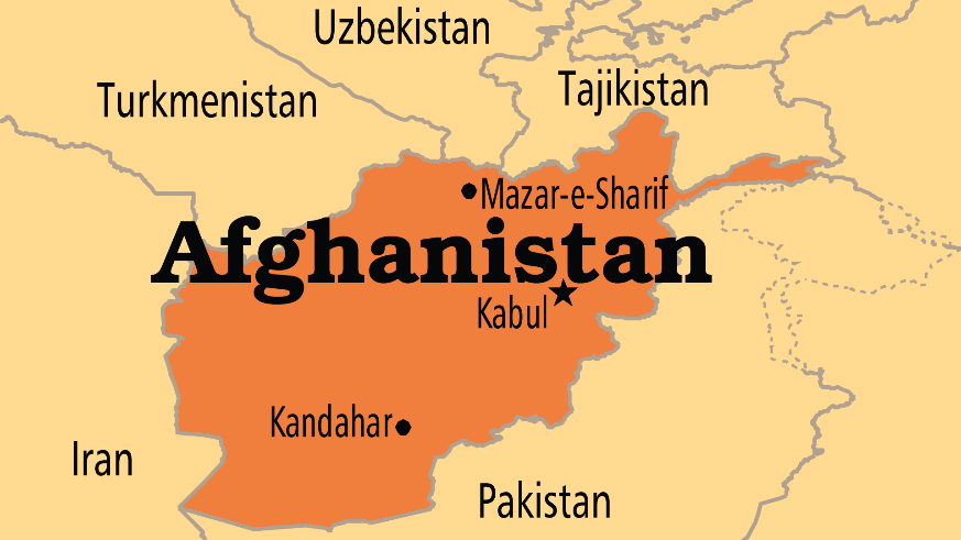
- 07 Sep 2025
In News:
A devastating 6.0-magnitude earthquake struck eastern Afghanistan near Jalalabad, killing over 800 people and injuring at least 2,800 across Kunar, Nangarhar, and Laghman provinces. The tremors, felt from Kabul to Islamabad, destroyed homes in remote mountainous regions and highlighted Afghanistan’s acute vulnerability to natural disasters.
Afghanistan’s Seismic Vulnerability
Afghanistan lies at the collision zone of the Eurasian and Indian tectonic plates, making it one of the world’s most seismically active regions. The Hindu Kush mountain range, part of the greater Himalayan system, witnesses frequent tremors. Since 1900, at least 12 earthquakes exceeding magnitude 7 have struck northeast Afghanistan.
Most Afghans live in low-rise, mud-brick dwellings, which offer little resistance to seismic shocks. With poor infrastructure, fragile governance, and limited access to technology, the human toll of disasters is amplified.
Geographic and Geostrategic Context
Afghanistan is a landlocked, multi-ethnic nation in South-Central Asia, historically situated at the crossroads of trade and power rivalries—from the “Great Game” between Britain and Russia to Cold War confrontations.
- Capital: Kabul
- Neighbours: Pakistan, Iran, Turkmenistan, Uzbekistan, Tajikistan, and China (via the narrow Wakhan Corridor).
- Geographic Features:
- Mountains: The Hindu Kush dominates, with passes like the Khyber and Shebar, linking Central and South Asia.
- Rivers: Amu Darya (north), Kabul River (tributary of Indus), Helmand (longest at 715 miles), and Hari Rud (Afghanistan–Iran boundary).
- Regions:
- Central Highlands – rugged, earthquake-prone terrain.
- Northern Plains – fertile, resource-rich areas with gas reserves.
- Southwestern Plateau – arid deserts such as Registan and Margow.
These geographical features make Afghanistan both strategically significant and highly disaster-prone.
Swarnamukhi River
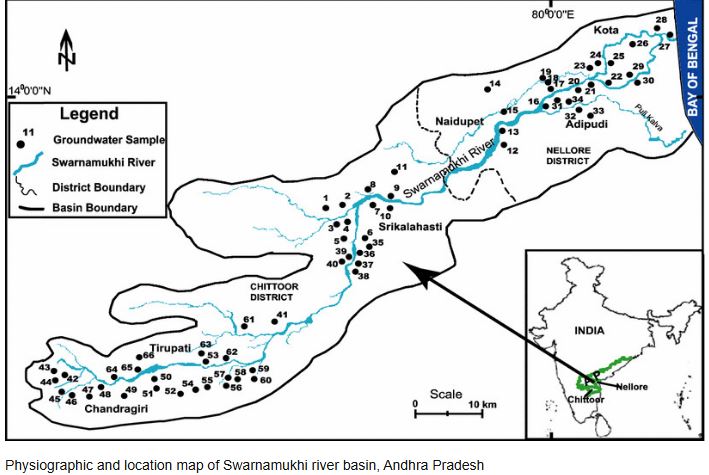
- 04 Sep 2025
In News:
The Tirupati Urban Development Authority (TUDA) has launched Operation SWARNA, a comprehensive initiative aimed at rescuing, reviving, and rejuvenating the River Swarnamukhi in Andhra Pradesh. The project seeks to restore the river’s ecological flow, protect it from encroachments, and ensure its long-term sustainability. Modeled on Hyderabad’s HYDRAA (Hyderabad Drainage and River Authority for Action and Awareness) framework, the proposed task force will be headed by the TUDA Vice-Chairman and vested with enforcement powers.
About River Swarnamukhi
- Location: Andhra Pradesh; an east-flowing river with a catchment area of 3,225 sq. km.
- Origin: Rises at ~300 m elevation in the Eastern Ghats near Pakala village, Chittoor district.
- Course: Flows 130 km northeast, passing through Tirupati hills, and joins the Bay of Bengal.
- Religious Significance: Passes through Tirumala and Srikalahasti, home to temples like the Srikalahasteeswara Temple.
- Hydrology:
- Independent river system, not connected to major rivers.
- Rain-fed; highly dependent on rainfall in upper catchments.
- Rainfall varies from 1270 mm (eastern side) to 762 mm (western side) of the basin.
- Tributary: Kalyani River, across which the Kalyani Dam (1977) regulates flow.
Challenges
- Encroachment and land grabbing along the riverbanks.
- Seasonal and irregular flows due to rainfall dependency.
- Decline in water quality and ecological health from urban pressures.
- Cultural risk: Threat to temple towns and their heritage that depend on the river.
Significance of Operation SWARNA
- Ecological revival: Ensures sustainable river flow and biodiversity restoration.
- Water security: Rejuvenation can enhance groundwater recharge and local water availability.
- Cultural preservation: Protects sacred towns of Tirumala–Srikalahasti corridor.
- Model initiative: Replicates the HYDRAA framework of Hyderabad, strengthening river governance.
Drake Passage

- 31 Aug 2025
In News:
A powerful earthquake of magnitude 7.5 struck the Drake Passage, the stretch of ocean between South America’s Cape Horn and the South Shetland Islands of Antarctica.
About Drake Passage
- Location: Lies between Cape Horn (South America) and the South Shetland Islands (Antarctica).
- Geography: A deep and wide waterway connecting the southwestern Atlantic and southeastern Pacific Oceans; also the narrowest stretch of the Southern Ocean, spanning nearly 800 km between South America and the West Antarctic Peninsula.
- Climatic Role: Marks a climatic transition zone, separating the cool, humid subpolar conditions of Tierra del Fuego from the frigid polar climate of Antarctica.
- Navigation: Considered among the roughest seas in the world due to the collision of cold southern currents and warmer northern waters, which create strong eddies, compounded by powerful westerly winds around Cape Horn.
- Historical Importance: Before the opening of the Panama Canal, it served as a vital maritime trade route in the 19th and early 20th centuries.
- Naming: The passage is named after Sir Francis Drake, the first Englishman to circumnavigate the globe.
Mercator Projection Map
- 27 Aug 2025
In News:
The African Union (AU) has endorsed the “Correct the Map”campaign, calling for the replacement of the Mercator projection with modern alternatives that represent Africa’s true size. This move is not just cartographic—it is deeply political, tied to questions of historical justice, cultural representation, and global perception.
The Mercator Projection: Origins and Features
- Introduced: 1569 by Gerardus Mercator, a Flemish mathematician and cartographer.
- Purpose: Designed for navigation, enabling sailors to follow a straight line of constant compass bearing (Rhumb lines/loxodromes).
- Structure:
- Meridians (longitude): parallel, vertical, equally spaced.
- Parallels (latitude): horizontal, spacing increases away from the equator.
- Grid forms right angles.
- Strengths: Conformal projection that preserves shapes and angles, ideal for maritime exploration.
- Limitations: Distorts area and scale. True scale exists only along the equator; distortion grows near the poles.
Distortions and Bias
- Africa & South America appear much smaller than their real size.
- Europe, North America, and Greenland are disproportionately enlarged.
- Example: Greenland (≈2.1 million sq km) appears similar in size to Africa (≈30 million sq km).
- Such distortions fed into Eurocentric worldviews, reinforcing colonial narratives of Africa as “smaller” and “conquerable.”
Corrective Measures
- Gall-Peters Projection (1970s): Area-accurate but distorts shapes. Adopted in some schools, e.g., Boston (2017).
- Equal Earth Projection (2018): Balances shape and area, providing a fairer representation of continents.
- AU’s Endorsement: By backing the Equal Earth projection, the AU aims to restore “Africa’s rightful place on the global stage,” highlighting the continent’s true scale and importance.
Almond Cultivation in Kashmir
- 24 Aug 2025
In News:
The almond harvest in Kashmir is not only a vital agricultural activity but also a culturally significant seasonal event. This year’s bumper crop has brought relief and optimism to local farmers, reinforcing the economic and social importance of almond cultivation in the region.
About Almonds:
- Almonds are among the oldest and most widely cultivated tree nuts in the world, with two primary types: sweet almonds and bitter almonds.
- They are used extensively in culinary preparations, including sweets, almond milk, and as raw nuts, and are also processed for almond oil.
Climatic and Soil Requirements:
- Climate: Almond trees thrive in colder regions.
- Temperature: Optimal growth occurs between 7°C and 24°C.
- Soil: Deep, loamy, well-drained soils are ideal.
- Rainfall: Requires an average of 75–110 cm of rainfall.
- Altitude: Can grow effectively at 750–3200 meters above sea level.
Global and Indian Context:
- Major producing countries: USA, Australia, Spain, Turkey.
- In India: Almond cultivation is concentrated in hilly and colder regions, primarily in Jammu & Kashmir, Himachal Pradesh, Uttarakhand, with smaller cultivation in Kerala and some hilly areas of Andhra Pradesh.
Economic and Cultural Significance in Kashmir:
- Almond farming provides livelihoods to thousands of farmers in the region.
- The harvest season coincides with local festivals and traditional practices, reinforcing the crop’s cultural relevance.
- This year’s abundant yield has boosted local income and food security.
Mud Waves
- 20 Aug 2025
In News:
A recent study published in Global and Planetary Change (2025) has uncovered 117-million-year-old mud waves buried nearly 1 km beneath the Atlantic seabed west of Guinea-Bissau. This finding reshapes our understanding of the formation of the Atlantic Ocean, ancient climate patterns, and tectonic shifts during the Cretaceous period.
About Mud Waves
- Definition: Large, rhythmic sedimentary structures formed on the seafloor by persistent bottom currents.
- Age & Size: Approximately 117 million years old; over 1 km long and several hundred meters high.
- Location: Deep seabed, west of Guinea-Bissau, near the Equatorial Atlantic Gateway.
- Composition: Layered sediments preserving evidence of historic ocean circulation.
Formation Process
- Early Atlantic Spillover: Around 117 million years ago, the young North Atlantic Ocean began spilling dense, salty waters into southern basins through the newly formed Equatorial Atlantic Gateway.
- Underwater Avalanches: The influx collided with older, stagnant waters rich in mud and organic matter, triggering massive sediment avalanches.
- Wave Formation: These currents pushed and piled up sediments into wave-like structures, which solidified into permanent mud waves over millions of years.
Scientific Significance
- Rewrites Ocean History: Suggests Atlantic waters circulated much earlier than previously thought.
- Climate Insights: Provides evidence of Cretaceous climate shifts and ancient carbon cycles.
- Tectonic Implications: Offers clues to plate movements shaping Earth’s geography during the breakup of Gondwana.
About the Atlantic Ocean
- Size & Shape: Second-largest ocean after the Pacific; distinctive ‘S’-shape.
- Major Features:
- Mid-Atlantic Ridge: 14,000 km long, ~4 km high, central seafloor mountain range.
- Continental Shelves: Widest along NE America and NW Europe.
- Islands & Seamounts: Azores, Canary Islands, Bermuda, Cape Verde.
- Trenches: Puerto Rico Trench, Romanche Trench (less prominent than Pacific trenches).
- Marginal Seas: Hudson Bay, Gulf of Mexico, Baltic Sea.
Wallacean Hominids

- 18 Aug 2025
In News:
Recent archaeological findings on Sulawesi Island, Indonesia, have revealed stone tools dating back to nearly 1.5 million years ago, marking the earliest known evidence of human presence in the Wallacea region.
Key Findings:
- Archaeologists from Australia and Indonesia discovered small, chipped stone tools in the Soppeng region of South Sulawesi.
- The artefacts, likely used to cut small animals and carve rocks, were found along with animal teeth.
- Radioactive dating suggests the tools are up to 1.48 million years old.
- These findings were published in Nature (August 2025).
Significance:
- The artefacts are attributed to Homo erectus, pre-historic hominids that lived long before the emergence of Homo sapiens.
- Previously, Homo erectus in Wallacea were thought to have occupied only Flores (Indonesia) and Luzon (Philippines) around 1.02 million years ago.
- The Sulawesi discovery pushes back the timeline by almost half a million years, challenging earlier assumptions that Homo erectus lacked the capacity for long-distance sea crossings.
- It provides crucial evidence of early maritime dispersal and migration patterns of ancient humans from the Asian mainland into island ecosystems.
About Wallacea:
- Wallacea is a biogeographic region in Eastern Indonesia, comprising islands such as Sulawesi, Lombok, Flores, Timor, and Sumbawa, situated between Borneo–Java and Australia–New Guinea.
- The region is named after Alfred Russel Wallace, the naturalist who studied its distinct biodiversity.
- It acts as a natural transitional zone between the fauna of Asia and Australia.
Dardanelles Strait
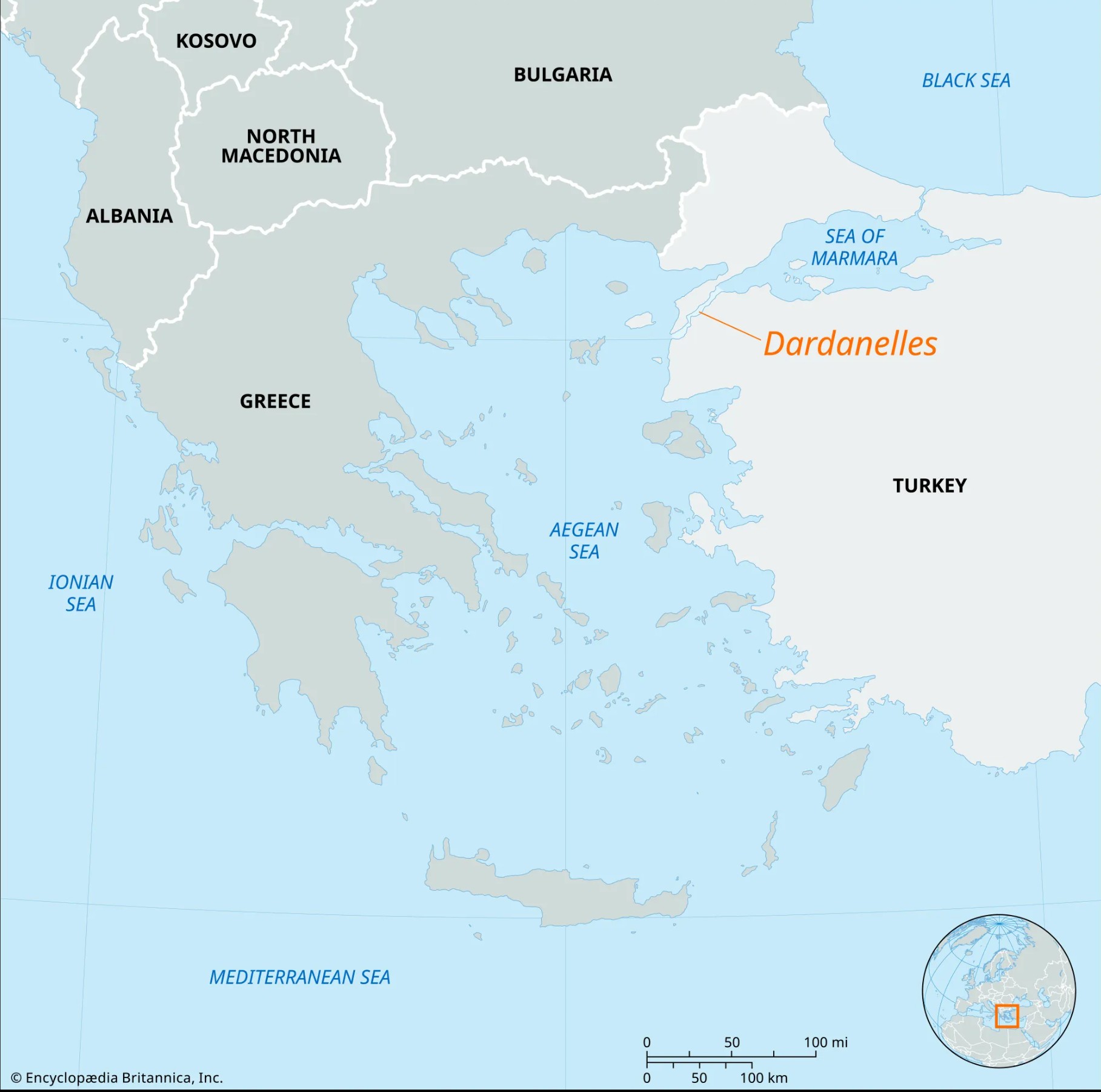
- 17 Aug 2025
In News:
The Dardanelles Strait, a narrow but vital maritime passage in northwestern Turkey, was recently closed to shipping traffic after severe forest fires broke out near Çanakkale province. The incident highlights the strait’s enduring strategic, economic, and environmental importance.
Geographical Overview
- Length: 61 km; Width: 1.2–6.5 km.
- Depth: Average ~55 m, maximum ~90 m in central narrow sections.
- Location: Separates the Gallipoli Peninsula (Europe) from Anatolia (Asia), lying entirely within Turkey’s territorial waters.
- Connectivity: Links the Aegean Sea to the Sea of Marmara, and with the Bosphorus Strait, forms the Turkish Straits system, connecting the Mediterranean to the Black Sea.
- Hydrology: Two-way currents – surface flow from Marmara to the Aegean, undercurrent in the reverse direction.
- Ports: Major ones include Gallipoli, Eceabat, and Çanakkale.
Strategic and Economic Significance
- Maritime Trade: Nearly 46,000 vessels crossed the Dardanelles in 2024, underscoring its role as a global shipping artery between Europe and Asia.
- Chokepoint Status: Serves as a gateway to Istanbul and the Black Sea, shaping regional power dynamics.
- Fisheries: Rich in migratory fish species, supporting local economies.
- Geopolitical Role: Critical for Turkey’s strategic influence, NATO security, and Black Sea maritime routes.
Historical Importance
- Known in antiquity as the Hellespont.
- Greek mythology: Associated with the tale of Hero and Leander.
- Ancient campaigns: Xerxes I of Persia crossed via a pontoon bridge (480 BCE); Alexander the Great crossed during his conquest of Asia (334 BCE).
- Modern conflicts: Key battleground in World War I’s Gallipoli Campaign, where Allied forces attempted but failed to seize control.
Sukhna Lake
- 14 Aug 2025
In News:
The Chandigarh Administration recently closed the floodgate of Sukhna Lake after water levels receded from the near-danger mark.
About Sukhna Lake
- Type: Artificial, rain-fed lake at the foothills of the Shivalik Hills, Chandigarh.
- Creation: Built in 1958 by damming the Sukhna Choe, a seasonal stream.
- Size: Originally 188 ha (now ~150 ha); length 1.52 km, width 1.49 km.
- Depth: Originally 18 ft, reduced to ~8.5 ft due to siltation.
- Ecological Importance:
- Declared a National Wetland by the Government of India.
- Habitat for ~30 species of resident and migratory birds, including Siberian ducks, storks, and cranes.
- Part of Sukhna Wildlife Sanctuary.
- Recreational Importance:
- Longest channel for rowing and yachting events in Asia.
- Surrounded by Nek Chand’s Rock Garden (west) and a golf course (south).
Mount LewotobiLakiLaki
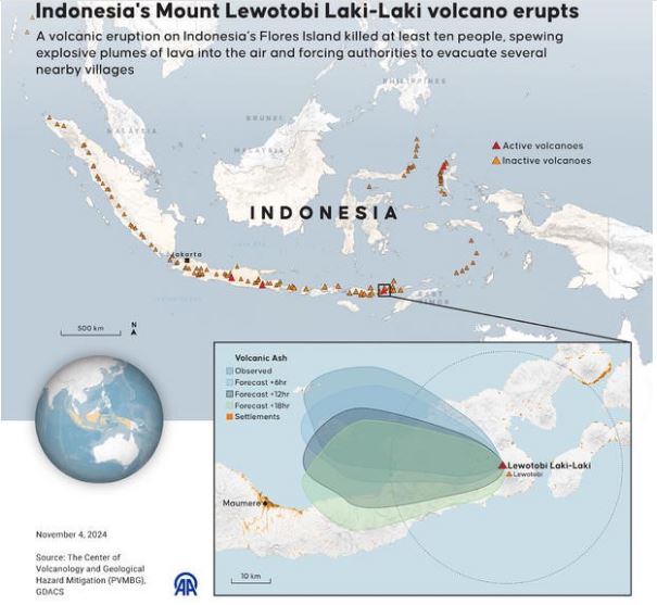
- 07 Aug 2025
In News:
Mount LewotobiLakiLaki, one of Indonesia’s most active volcanoes, erupted in August 2025, spewing volcanic ash up to 18 km into the atmosphere and blanketing nearby villages on the island of Flores. The eruption followed another event just hours earlier, which sent ash plumes 10 km high, accompanied by glowing lava and volcanic lightning.
Key Features of the Eruption
- Scale: Among Indonesia’s largest volcanic events since the 2010 Mount Merapi eruption, which killed over 350 people and displaced hundreds of thousands.
- Hazards Observed:
- Pyroclastic flows of gas, rocks, and lava up to 5 km down the slopes.
- Volcanic debris, including hot gravel, scattered as far as 8 km from the crater.
- Risk of lahars (volcanic mudflows) triggered by heavy rainfall.
- Alert Status: Indonesia’s Geology Agency placed the volcano on the highest alert level since June 18, 2025. The exclusion zone was extended to 7 km radius. Thousands of residents have been permanently relocated due to repeated eruptions, including a deadly series in November 2024 that killed nine and destroyed homes.
Geological Context
- Volcano Type: Part of the Lewotobi twin stratovolcano system (“husband and wife”), comprising:
- LewotobiLakiLaki (male)
- Lewotobi Perempuan(female)
- Location: Island of Flores, Indonesia.
- Height: 1,584 metres (5,197 feet).
- Ring of Fire Connection:
- Situated along the Pacific Ring of Fire (Circum-Pacific Belt), a 40,000 km horseshoe-shaped zone around the Pacific Ocean.
- Hosts 75% of Earth’s volcanoes (over 450) and accounts for 90% of global earthquakes.
Krasheninnikov Volcano
- 06 Aug 2025
In News:
The Krasheninnikov volcano, located in Russia’s Kamchatka Peninsula, recently erupted for the first time in recorded history. The eruption followed a nearby magnitude 8.8 earthquake and released ash plumes reaching 20,000 ft (≈6,000 m) into the atmosphere. Authorities issued an “orange” aviation hazard code due to potential risks to air traffic.
About Krasheninnikov Volcano
- Type: Active stratovolcano (composite volcano).
- Height: ~1,856–1,886 m.
- Structure: Formed within a 9 km wide collapsed caldera created by a massive eruption ~39,600 years ago that expelled 50 cubic km of dacitic pumice.
- Cones: Contains two eruptive cones; the southern cone has an 800 m wide, 140 m deep crater.
- Past Activity: Last known eruption occurred ~400–600 years ago.
Kamchatka Peninsula – Volcanic Hotspot
- Lies along the Pacific “Ring of Fire”, one of the world’s most seismically active zones.
- Home to 114 Holocene volcanoes (eruptions recorded in the last ~12,000 years).
- Known for frequent explosive eruptions due to subduction of the Pacific Plate beneath the Eurasian Plate.
Stratovolcano – Key Features
- Steep, conical structure with alternating layers of lava and pyroclastic deposits.
- Typically found above subduction zones (e.g., Pacific Ring of Fire).
- Characterized by explosive eruptions due to viscous andesite/dacite lavas that trap gases.
- Account for about 60% of Earth’s volcanoes.
- Example: Mount Fuji (Japan), Mount Vesuvius (Italy), Mount St. Helens (USA).
Significance of 2025 Eruption
- First recorded activity of Krasheninnikov highlights the unpredictability of dormant volcanoes.
- Demonstrates the link between major seismic events and volcanic eruptions in tectonically active zones.
- Raises concerns for aviation safety, regional ecology, and monitoring of Ring of Fire volcanism.
National Waterway-57 (River Kopili)
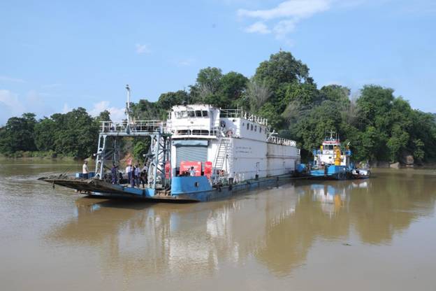
- 05 Aug 2025
In News:
In a landmark development for sustainable logistics in the Northeast, the Kopili River (National Waterway-57) was operationalised with the maiden cargo movement of 300 MT of cement from Chandrapur (Kamrup) to Hatsingimari (South Salmara, Assam).
About the Kopili River
- Origin:Saipong Reserve Forest in the Borail Range, North Cachar Hills, at 1,525 m altitude.
- Length: 256 km (78 km along the Assam–Meghalaya border; 178 km in Assam).
- Basin Coverage: Flows through Meghalaya and Assam, making it an interstate river.
- Significance: Largest south bank tributary of the Brahmaputra in Assam; traverses North Cachar Hill, KarbiAnglong, Nagaon, and Morigaon districts.
- Agricultural Zone: Supports cultivation of rice (winter, summer, autumn), wheat, mustard, and rapeseed in Kamrup and surrounding areas.
Strategic and Policy Significance
- Economic Impact: Reduces road congestion, lowers logistics costs, and provides an efficient alternative for bulk cargo. The trial run replaced the equivalent of 23 truckloads of cement.
- Environmental Gains: Inland water transport curbs emissions and promotes sustainable logistics.
- Regional Development: Enhances connectivity for riverine communities, boosts trade, and unlocks economic opportunities in Assam.
- National Integration: Aligns with Maritime India Vision 2030 and PM Gati Shakti, which seek to create multimodal, integrated transport infrastructure.
8.8-magnitude earthquakenear Russia’s Kamchatka Peninsula
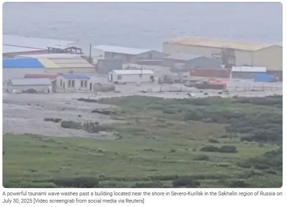
- 02 Aug 2025
In News:
- Recently, a magnitude 8.8 megathrust quake struck off the eastern coast of Kamchatka Peninsula, one of the largest ever recorded globally.
- This quake ranks among the six strongest recorded since modern seismology began—comparable to events in Ecuador (1906) and Chile (2010)—but caused remarkably limited damage.
- It originated in the Kuril–Kamchatka subduction zone, where the denser Pacific Plate thrusts beneath the North American/Okhotsk plates—a region known for frequent tectonic activity. The rupture extended over 200–300 miles underwater.
Tsunami: Warnings, Impact, and Aftermath
- The quake triggered tsunami alerts across the Pacific: Japan, the U.S. West Coast, Alaska, Hawai‘i, Chile, Ecuador (Galápagos), and French Polynesia, among others, issued multi-national warnings.
- In Kamchatka, waves between 3 to 5 meters struck, inundating the port and fish-processing plants in Severo-Kurilsk.
- Locally in Severo-Kurilsk, the quake caused serious structural damage to residential and social infrastructure, once again highlighting its vulnerability—especially recalling the catastrophic 1952 earthquake and tsunami that devastated the town.
Volcanic Aftermath: A Volcanic Chain Reaction
- In the quake’s wake, six volcanoes on Kamchatka became active. Most notably, Krasheninnikov erupted for the first time in 600 years, while others like KlyuchevskayaSopka, Shiveluch, Bezymianny, Karymsky, and Avachinsky also showed signs of eruption.
- This surge in volcanic activity—sparked by seismic fracturing of the crust—is considered a rare geological cascade, comparable to events last seen in 1737. Ash plumes reached up to 10 km height, posing aviation hazards.
Historical Perspective: Kamchatka’s Seismic Legacy
- 1952 Severo-Kurilsk Earthquake (Mag 8.8–9.0) caused a massive tsunami up to 18 meters, killing thousands and destroying the original town. It remains a defining tragedy in Russia’s seismic history.
- Earlier, the 1923 Kamchatka quake (Mag ~7–8) generated a tsunami that reached Hawaii and California’s coastlines, showing long-standing Pacific-wide impacts.
- These events underline the repeatable seismic vulnerability of the region and importance of preparedness.
Winter Fog Experiment (WiFEX)
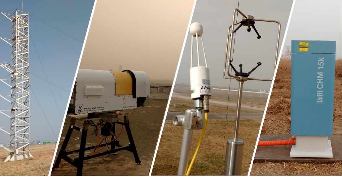
- 23 Jul 2025
In News:
The Winter Fog Experiment (WiFEX) has completed ten successful years since its launch in 2015. Initiated at the Indira Gandhi International Airport (IGIA), New Delhi, WiFEX has emerged as a pioneering long-term scientific initiative aimed at understanding and mitigating the impact of dense winter fog over the Indo-Gangetic Plain (IGP) — one of the most fog-prone regions in the world.
What is WiFEX?
- Launched in Winter 2015 at IGIA, New Delhi.
- Led by the Indian Institute of Tropical Meteorology (IITM) under the Ministry of Earth Sciences (MoES).
- Supported by:
- India Meteorological Department (IMD)
- National Centre for Medium Range Weather Forecasting (NCMRWF).
- One of the world’s few open-field long-term experiments exclusively dedicated to studying winter fog.
Objectives of WiFEX
- To develop accurate now-casting (up to 6 hours) and forecasting systems for fog events over North India.
- To reduce the adverse impact of fog on:
- Aviation (flight delays, diversions, safety).
- Surface transport (road and rail accidents).
- Economy and public safety.
How it was Conducted
Observational Framework
WiFEX deployed cutting-edge scientific equipment, including:
- Micrometeorology towers
- Ceilometers
- High-frequency sensors
- Radiometers
- Wind profilers
These were installed at multiple locations including:
- IGIA, Delhi
- Jewar Airport, Noida
- Hisar, Haryana
Key Parameters Studied
- Atmospheric temperature stratification
- Relative humidity and soil heat flux
- Wind speed and turbulence
- Aerosol concentration
- Urban heat island effects
- Land-use changes
This comprehensive data helped scientists decode how dense fog forms, persists, and disperses.
Major Achievements of WiFEX
High-Resolution Forecasting Model
- A 3-km resolution probabilistic fog prediction model was developed.
- Achieved over 85% accuracy in forecasting very dense fog (visibility <200 meters).
- Provides insights on:
- Onset and dissipation timing
- Fog density
- Duration of fog events
Operational Impact
- Significantly reduced flight diversions and delays at IGIA.
- Enhanced airport safety and efficiency in fog conditions.
- Helped airlines and transport authorities activate timely contingency plans.
Scientific Contributions
- Showcased how air pollution, aerosols, urbanization, and land-use changes influence fog behavior.
- Facilitated improvements in early warning systems for North India.
- Informed urban planning and air quality policies for fog-prone areas.
Guryul Ravine Fossil Site

- 22 Jul 2025
In News:
The Geological Survey of India (GSI) has raised an alarm over a serious threat to the Guryul Ravine fossil site located in Khonmoh, on the outskirts of Srinagar, Jammu & Kashmir. The site holds immense geological significance and is facing the risk of degradation due to human activity.
About the Site
The Guryul Ravine is situated near Khonmoh in Jammu & Kashmir, close to the Dachigam National Park. Geologically, the area is part of the Vihi district. It falls within the ecologically sensitive Khonmoh Conservation Reserve.
- This fossil site is globally significant because it contains sedimentary layers that preserve evidence of the Permian–Triassic mass extinction event. These geological layers date back around 260 million years and represent one of the most catastrophic periods in Earth’s biological history.
- Remarkably, the site also shows signs of what is believed to be the world’s earliest recorded tsunami, with the imprint still visible in the exposed strata.
Significance of the Permian–Triassic Extinction Event
- Also referred to as the “Great Dying,” the Permian–Triassic extinction event occurred around 251.9 million years ago. It marks a major boundary between the Permian and Triassic geological periods and also separates the Paleozoic and Mesozoic eras.
- This event was the most severe extinction episode in Earth’s history. It led to the loss of nearly 90–95% of marine species and about 70% of terrestrial vertebrate species. The extinction dramatically reshaped life on Earth and paved the way for the rise of dinosaurs in the subsequent Mesozoic era.
Conservation Concerns
- The GSI has warned that this invaluable geo-heritage site is under threat due to encroachment and unregulated activities. It has recommended urgent steps to protect the fossil-rich area to preserve its scientific and educational value.
Noctilucent Clouds

- 17 Jul 2025
In News:
Recently, rare noctilucent clouds were sighted over parts of Scotland, drawing attention due to their unique shimmering appearance in the night sky. These occurrences are significant in the context of climate studies and upper atmospheric science.
What are Noctilucent Clouds?
- Definition: Noctilucent clouds (NLCs), also known as polar mesospheric clouds, are high-altitude ice crystal clouds that appear thin, wispy, and glow with a blue or silvery hue after sunset.
- Etymology: The term “noctilucent” is derived from Latin—"nocto" (night) and "lucent" (shining)—meaning "night shining."
Atmospheric Location
- These are the highest clouds in Earth’s atmosphere, found in the mesosphere, around 76–85 km above the Earth's surface.
- In contrast, most other cloud types form in the troposphere, the lowest atmospheric layer.
Seasonal and Geographical Occurrence
- Seasonality:
- Northern Hemisphere: Visible from late May to early August, peaking during June and July.
- Southern Hemisphere: Much rarer; may appear from late November to early February, most commonly in December and January.
- Latitude Range: Typically occur between 45° and 80° latitude, both north and south of the equator.
- Visibility Conditions:
- Seen only during summer months, shortly after sunset or just before sunrise.
- The Sun remains just below the horizon, illuminating these high clouds from below, creating a glowing effect while the lower atmosphere is in darkness.
Formation Mechanism
- Composition: Made up of tiny ice crystals.
- Temperature Conditions: The mesosphere becomes extremely cold during summer, enabling the formation of ice on fine particles.
- Sources of Dust Nuclei:
- Natural: Micrometeorites, volcanic dust.
- Anthropogenic: Rocket exhaust particles and other upper-atmospheric pollutants.
- Optical Phenomenon: These ice crystals reflect sunlight even when the lower atmosphere is dark, giving them their luminous appearance.
Significance
- Serve as indicators of mesospheric conditions, especially temperature and humidity.
- Their increasing frequency and intensity in recent decades may be linked to climate change and human activities, including space exploration.
- Valuable for understanding upper atmospheric dynamics, particularly in the context of atmospheric chemistry and space weather.
Lake Turkana Basin
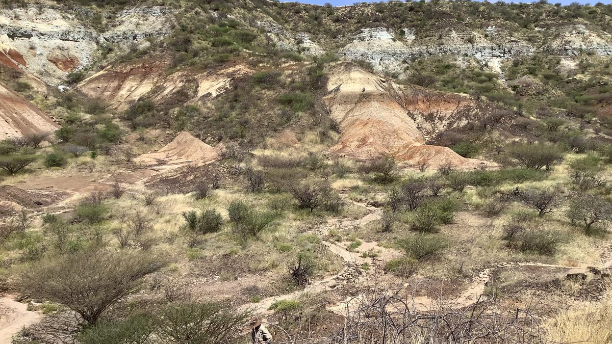
- 15 Jul 2025
In News:
For the first time, scientists have successfully extracted and analyzed 18–24 million-year-old enamel proteins from extinct mammal fossils—pushing the frontiers of biomolecular preservation and reshaping our understanding of mammalian evolution. The groundbreaking findings were published in Nature (July 2025) and draw from fossils found in Lake Turkana Basin (Kenya) and the Haughton Impact Crater (Canada's High Arctic).
Key Highlights:
What was Discovered?
- Enamel proteins, trapped in the dense tooth enamel of extinct mammals, were recovered from fossils dating back 18–24 million years.
- These proteins are now the oldest biomolecular sequences ever recovered, exceeding the time limits of ancient DNA (which typically degrades within 1 million years).
Significance of Enamel Proteins:
- Enamel—being the hardest biological substance—acts as a molecular vault, shielding proteins from environmental degradation.
- These ancient proteins provide crucial phylogenetic information, even in hot tropical zones like Lake Turkana, where preservation was previously thought improbable.
Methodology:
- Researchers extracted structural enamel proteins like amelogenin, enamelin, and ameloblastin.
- Advanced mass spectrometry and rigorous contamination controls ensured data integrity.
- Over 1,000 peptides and 7 different enamel proteins were recovered from a 21–24 million-year-old rhinoceros tooth in the Arctic.
- Diagenetic alterations (e.g., oxidation, glycation) were used as authenticity markers.
Site-Wise Discoveries:
Lake Turkana Basin (Kenya):
- Fossils from a hot, arid region yielded enamel proteins up to 18 million years old.
- Demonstrated exceptional preservation due to fluviodeltaic sedimentation, which allowed rapid burial and protection from oxygen and heat.
- The Turkana Basin is a major palaeontological site in Eastern Rift Valley and home to species like proboscideans, rhinocerotids, hippopotamids, and hominoids.
- Enamel samples ranged from 1.5 to 29 million years old.
- Turkana Lake, the world’s largest permanent desert lake and a UNESCO World Heritage Site, lies in this region.
Haughton Impact Crater (Nunavut, Canada):
- Ancient enamel from a permafrost site enabled recovery of 21–24 million-year-old proteins.
- The site was once a temperate lake, aiding preservation under low oxygen (anoxic) conditions.
- Researchers reconstructed rhinocerotid evolution, showing Epiaceratherium diverged before the Elasmotheriinae-Rhinocerotinae split, revising long-held fossil-based phylogenies.
Scientific Implications:
|
Aspect |
Enamel Proteins |
Ancient DNA |
|
Age limit |
>20 million years |
<1 million years |
|
Preservation |
High in enamel |
Poor in hot climates |
|
Resolution |
Useful for deep-time splits |
High for closely related species |
|
Data Type |
Protein sequence |
Genetic sequence |
|
Application |
Tree of life reconstruction, evolutionary history |
Genome mapping, ancestry |
Tokara Islands
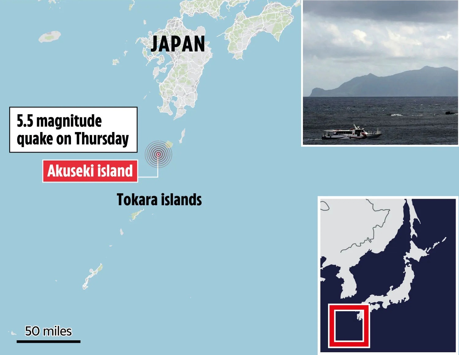
- 07 Jul 2025
In News:
In an unusual seismic episode, over 1,000 earthquakes have struck the Tokara Islands in southern Japan since June 1, 2025, triggering panic, evacuation orders, and heightened concerns about a potential larger earthquake. The persistent tremors—several of which registered magnitudes of 5.5 or higher—have had a significant psychological and logistical impact on the island's residents.
About Tokara Islands:
- Located south of Kyushu and north of the Amami Islands, the Tokara archipelago (also called Toshima Islands) consists of seven inhabited and five uninhabited islands.
- The inhabited islands include Kuchinoshima, Nakanoshima, Suwanosejima, Tairajima, Akusekijima, Kodakarajima, and Takarajima.
- Administered by Toshima Village, it is Japan’s longest village, stretching over 160 km.
- Nakanoshima is the largest and most populated island; it is dominated by Mount Otake (979 m).
- The islands lie in a subtropical-temperate climate zone, receiving around 2,700 mm of rainfall annually.
- Geologically, they are situated in one of the most earthquake-prone zones globally.
Roll Cloud

- 06 Jul 2025
In News:
A striking atmospheric event unfolded over Portugal’s coastline during a severe European heatwave, where beachgoers and weather enthusiasts witnessed a rare roll cloud. The phenomenon occurred as cooler Atlantic air met the hot, dry continental air, producing a visually stunning and scientifically intriguing cloud formation.
What is a Roll Cloud?
A roll cloud is an uncommon, tube-shaped, low-altitude cloud formation that appears to rotate horizontally along its axis. Unlike funnel clouds, it is not connected to any thunderstorm base or rotating system.
Typical Occurrence Zones:
- Frequently spotted in coastal areas, particularly where oceanic and continental air masses interact
- Notably seen in regions like:
- U.S. Great Plains
- Gulf of Carpentaria, Australia (famous for “Morning Glory” clouds)
- Atlantic coasts of Europe
Formation Mechanism:
- Air Mass Interaction: Roll clouds develop when cool, moist maritime air confronts hot, dry air from land, creating instability.
- Temperature Inversion: A thermal inversion layer traps cooler air beneath a warmer layer, suppressing vertical air movement.
- Gravity Waves: As dense cool air undercuts warm air, it creates gravity waves—oscillations within the lower atmosphere.
- Adiabatic Cooling: The ascending portion of the wave cools rapidly, leading to condensation and cloud formation.
- Detached Structure: The cloud remains independent of any parent cloud system, often forming a long, horizontal roll.
Cloud Characteristics:
- Shape: Long, tubular, and low-lying—can stretch over hundreds of kilometers
- Motion: Appears to roll horizontally like a barrel
- Timing: Often forms during early morning hours
- Orientation: Aligns with low-level wind flow, sometimes influenced by sea breeze or nocturnal land breeze fronts
Why are Roll Clouds important?
- Serve as visual indicators of atmospheric instability and changing weather conditions
- Though not hazardous, they reflect mesoscale meteorological processes
- May signal localized shifts in temperature or wind that could precede storm activity in some environments
- Their presence also highlights the interplay between land-sea thermal contrasts, especially relevant in the context of climate variability
Subarnarekha River
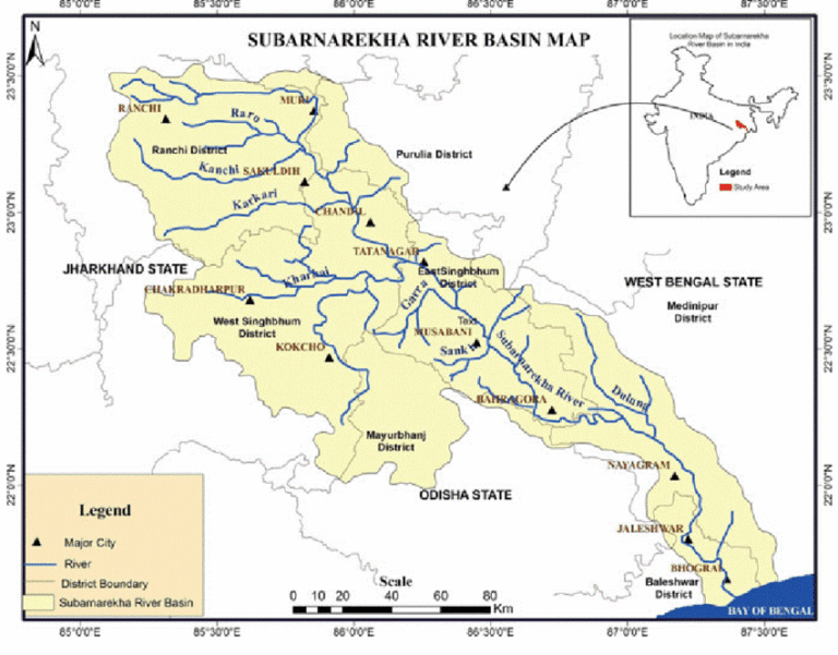
- 24 Jun 2025
In News:
A flash flood in the Subarnarekha River affected over 50,000 people in Balasore district, Odisha. The flooding was triggered by heavy rainfall and the release of water from Chandil Dam in Jharkhand.
About Subarnarekha River
Origin:
- Arises near Piska/Nagri, close to Ranchi, in Jharkhand.
- The name "Subarnarekha" means “Streak of Gold”, referring to traces of gold once found in the river’s origin area.
Geographical Course:
- States Covered: Jharkhand, West Bengal, Odisha.
- Mouth: Empties into the Bay of Bengal near Talsari, in Odisha.
- Total Length: Approx. 395 km.
- Drainage Basin Area: 18,951 sq. km, making it a relatively small multi-state river basin.
- Course Details: Flows through Paschim Medinipur (WB) and Balasore (Odisha) after originating in Jharkhand.
Key Features:
- Hundru Falls: A well-known waterfall on Subarnarekha, located in Jharkhand, with a drop of 98 metres.
- The river system is independent, not a tributary of any larger river.
- Known for its historical and cultural significance due to gold particles in its sands.
Major Tributaries:
- Kharkai (joins at Jamshedpur)
- Kanchi, Roro, Harmu Nadi, Dulunga, Karru, Karakari, Singaduba, Kodia, Dhamra
About Chandil Dam
Location:
- Situated in Chandil, Seraikela Kharsawan district, Jharkhand.
- Built near the confluence of the Subarnarekha River and Karkori River (originating from Hundru Falls).
Purpose:
- Multi-purpose project serving irrigation, flood control, and tourism.
- Plays a significant role in managing water flow in the Subarnarekha basin.
Kerch Strait and Recent Developments
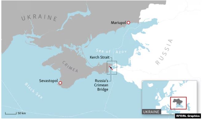
- 07 Jun 2025
In News:
Ukraine has claimed responsibility for a recent underwater explosion that damaged the Kerch Bridge, a critical transport link connecting mainland Russia to occupied Crimea. The attack underscores the strategic importance of the Kerch Strait in the ongoing Russia-Ukraine conflict.
Kerch Strait: Geographical and Strategic Overview
- Location: The Kerch Strait forms the only maritime passage between the Black Sea and the Sea of Azov.
- Geographical Boundaries:
- West: Kerch Peninsula (Crimea)
- East: Taman Peninsula (Russia)
- Width: Narrows to 3–5 km at its tightest point near the Chushka Spit.
- Nearby City: Kerch, located on the Crimean side, lies near the strait’s midsection.
- Strategic Importance:
- A vital shipping lane for transporting goods and military supplies.
- Gained heightened geopolitical importance after Russia's annexation of Crimea in 2014.
- Frequently features in Russia–Ukraine maritime tensions.
Kerch Strait Bridge (Crimean Bridge)
- Length: 19 km, making it the longest bridge in Europe.
- Completed: In 2018
- Connectivity: Includes dual road and railway tracks, linking the Russian mainland to Crimea.
- Symbolism: Considered a symbol of Russia’s control over Crimea post-2014 annexation.
- Strategic Use: Facilitates military logistics and civilian transit; crucial for sustaining Russian presence in Crimea.
Stromatolites in India
- 30 May 2025
In News:
600-million-year-old stromatolites in the Himalayas tell the story of an ocean lost and Earth’s first breath.
What are Stromatolites?
Stromatolites are organo-sedimentary structures formed by the entrapment of calcium carbonate precipitates by cyanobacteria (blue-green algae) in shallow marine environments. These layered, dome-shaped mounds represent some of the earliest evidence of life on Earth, with their formation driven by photosynthetic microbial mats.
- Composition: Typically found in limestone, shale, and sandstone.
- Structure: Characterized by laminated layers that may appear flat, dome-shaped, or columnar.
- Habitat (Ancient & Modern): Mostly marine; some ancient forms inhabited freshwater and intertidal zones. Today, living stromatolites survive in limited saline lagoons and bays.
Latest Discovery: Chambaghat, Himachal Pradesh
A major stromatolite outcrop, dating back 600 million years, was recently found in Chambaghat, Solan district, Himachal Pradesh. These structures lie within the Krol Group of sedimentary rocks — a part of the ancient Tethys Sea that existed before the Indian plate collided with Eurasia.
- Elevation: Found at 5,000–6,000 ft above sea level, showcasing tectonic uplift.
- Age Significance: Though not the oldest globally or in India, these are among the younger but well-preserved stromatolites, possibly from the Precambrian-Cambrian boundary (~543–548 million years ago).
Scientific Importance
- Geological Record: Stromatolites document Earth's atmospheric shift from a greenhouse gas-rich to an oxygen-rich environment — a transformation driven by photosynthetic cyanobacteria.
- The Great Oxidation Event (GOE): Occurred ~2.4 billion years ago, when oxygen produced by cyanobacteria began accumulating in the atmosphere, enabling the evolution of multicellular life.
- Tectonic History: Their presence in the Himalayas illustrates the story of the Gondwana supercontinent, India’s northward drift, and the closure of the Tethys Sea.
Global and Indian Context
- Oldest Stromatolites (Global): ~3.6 billion years old from Western Australia.
- Oldest in India: ~2.5 billion years old in the Dharwar Supergroup, Karnataka.
Prominent Stromatolite Sites in India:
Region Geological Feature
Chitrakoot, Uttar Pradesh Columnar stromatolites in Vindhyan limestones
Morni Hills, Haryana Preserved stromatolites in dolomite
Mussoorie & Nainital, Uttarakhand Precambrian marine stromatolites in Krol Belt
Jaisalmer Fossil Park, Rajasthan Protected Mesozoic marine fossil site
Dharwar Supergroup, Karnataka Neoarchean stromatolites (~2.6 billion years old)
Bhima Basin, Karnataka Precambrian stromatolites in shallow marine limestones
Preservation and Geoheritage
Geologists and experts advocate for declaring Chambaghat as a Geoheritage Park, involving local communities and schools to foster awareness. The goal is to integrate science with tourism, conservation, and education.
- Challenge: Many stromatolitic sites across India face neglect or risk from mining and construction, despite their scientific and educational potential.
- Appeal: Proposal for UNESCO Geoheritage status to protect and promote this prehistoric legacy.
India’s Coastline Redefined
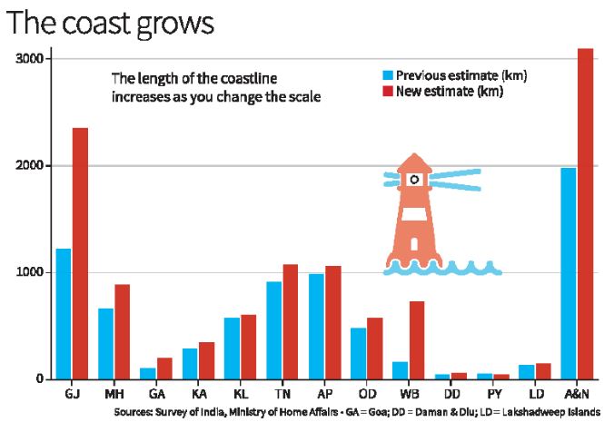
- 26 May 2025
In News:
The Ministry of Home Affairs, in its 2023–24 annual report (Dec 2024), announced a significant update to India’s coastline length — revised from 7,516.6 km to 11,098.8 km. This change was not due to any new territorial acquisition or geological activity but resulted from improved measurement techniques, reflecting the "coastline paradox" in geography.
What Is the Coastline Paradox?
The coastline paradox, first explained by British mathematician Lewis Fry Richardson and later expanded by Benoît Mandelbrot, shows that the length of a coastline increases with finer measurement scales. This is because coastlines, like fractals, reveal more detail (creeks, estuaries, inlets) the more closely they are examined.
- Using large-scale maps (e.g., 1:4,500,000), previous estimates missed finer details.
- Modern tools allow capturing every tidal creek, sandbar, and estuarine curve, dramatically increasing measured length.
Measurement Methodology (2024 Update)
Aspect Details
Agencies Involved National Hydrographic Office (NHO), Survey of India
Previous Map Scale 1:4,500,000 (1970s)
New Map Scale 1:250,000 (electronic navigation charts)
Key Technologies GIS, LIDAR-GPS, satellite altimetry, drone imaging
Reference Line Used Highwater Line (based on 2011 data)
Mapped Features Included Tidal creeks, sandbars, estuaries, low-tide islands
Review Frequency Every 10 years from 2024–25
Geographical and Strategic Overview
- India’s New Coastline Length: 11,098.8 km
- No New Land Added: No change in land boundaries or annexation.
- Coastal States & UTs: 11 coastal States + 2 UTs (Andaman & Nicobar Islands, Lakshadweep)
- State with Longest Coastline: Gujarat (~1,600 km)
Why This Matters
1. Maritime Security
- Longer coast = More area to monitor and protect.
- Post-26/11, India enhanced coastal surveillance (radar grid, coastal police).
- Navy and Coast Guard deployment strategies need updates.
2. Disaster Management
- Accurate coastline data helps in cyclone, tsunami early warning systems (e.g., Odisha).
- Supports better Coastal Regulation Zone (CRZ) mapping.
3. Economic and Strategic Planning
- Affects Exclusive Economic Zone (EEZ) and fishing rights.
- Informs infrastructure development: ports, shipping, Sagarmala, tourism.
- Boosts India’s aspirations in the Blue Economy.
Mount Marapi Eruption

- 06 Apr 2025
In News:
In May 2025, Mount Marapi, one of Indonesia’s most active volcanoes, erupted, spewing a column of volcanic ash 1.5 km into the sky. The event has once again highlighted the seismic vulnerability of the Pacific Ring of Fire, where tectonic activity frequently triggers volcanic eruptions and earthquakes.
About Mount Marapi
- Location: Situated in the Padang Highlands of western Sumatra, Indonesia.
- Type: A stratovolcano (composite volcano), consisting of successive layers of lava, ash, and pyroclastic material.
- Elevation: Rises to 2,891 meters (9,485 feet) above sea level, making it the highest peak in the region.
- Summit Feature: Contains the Bancah caldera (approx. 1.4 km wide), with multiple overlapping craters.
- Tectonic Setting: Lies on the Pacific Ring of Fire, a highly seismically active zone encircling the Pacific Ocean.
- Notable Eruption: In 1979, a deadly eruption-induced lahar (volcanic mudflow) caused by intense rainfall resulted in 60 fatalities.
Naini Lake
- 04 Apr 2025
In News:
Naini Lake record-low water levels in 2025.
Geographical and Environmental Significance
- Location: Heart of Nainital, Uttarakhand.
- Type: Natural, kidney-shaped freshwater lake.
- Surroundings: Enclosed by seven hills.
- Deepest Point: 89 feet.
- Gauge Level: 12 feet (normal level).
- Water Level (2025): 4.7 feet – lowest in 5 years, nearing “zero level”.
- Zero Level Meaning: Water level below normal gauge, not fully dry.
Ecological & Civic Importance
- Water Source: Supplies 10 million litres/day of drinking water.
- 2024 Dependence: Met 76% of Nainital’s water demand.
- Aquifer Recharge:Sukhatal Lake is a major recharge zone.
Factors Behind Depletion
1. Climate Variability
- Rising Temperatures: +1.5°C rise in Uttarakhand (1970–2022).
- Rainfall Data:
- 2022: 2400 mm (good year).
- 2024: Dropped to 2000 mm.
- Winter Rainfall (Jan–Mar 2025): 107 mm.
- Snowfall Days:
- 2022: Four.
- 2025: None.
2. Anthropogenic Pressures
- Urbanisation& Encroachment:
- Concrete construction → low rainwater infiltration.
- Encroachments on wetlands and recharge zones.
- Pollution Issues:
- Untreated wastewater discharge.
- Improper solid waste disposal.
- Overflowing sewage into stormwater drains.
- Tourism & Homestays:
- High tourist influx.
- Rise in homestays; ~1 in 3 houses converted.
Institutional & Governance Challenges
- Overlapping Jurisdictions:
- Inadequate coordination among agencies.
- Aging Infrastructure:
- Old water distribution system, unable to meet demand.
- Reports Highlighting Issues:
- USCST 2017:Naini Lake most manipulated among Kumaon lakes.
- 2024 Research (CEDAR): Faulty water governance exacerbating stress.
Legal and Civic Interventions
- SC Intervention (1993): Ban on commercial complex projects.
- Uttarakhand HC (2022): Stay on Sukhatal beautification project.
- Petitions Filed: Alleging degradation due to construction on recharge areas.
Way Forward
- Ecosystem-Based Approach: Recognize catchment area, slope vulnerability, and recharge zones.
- Rejuvenation Focus:Prioritisenatural hydrological restoration over tourism promotion.
- Sustainable Urban Planning: Regulation of construction, homestays, and infrastructure development.
Strength of Cloud Bands and their role in Indian Monsoon
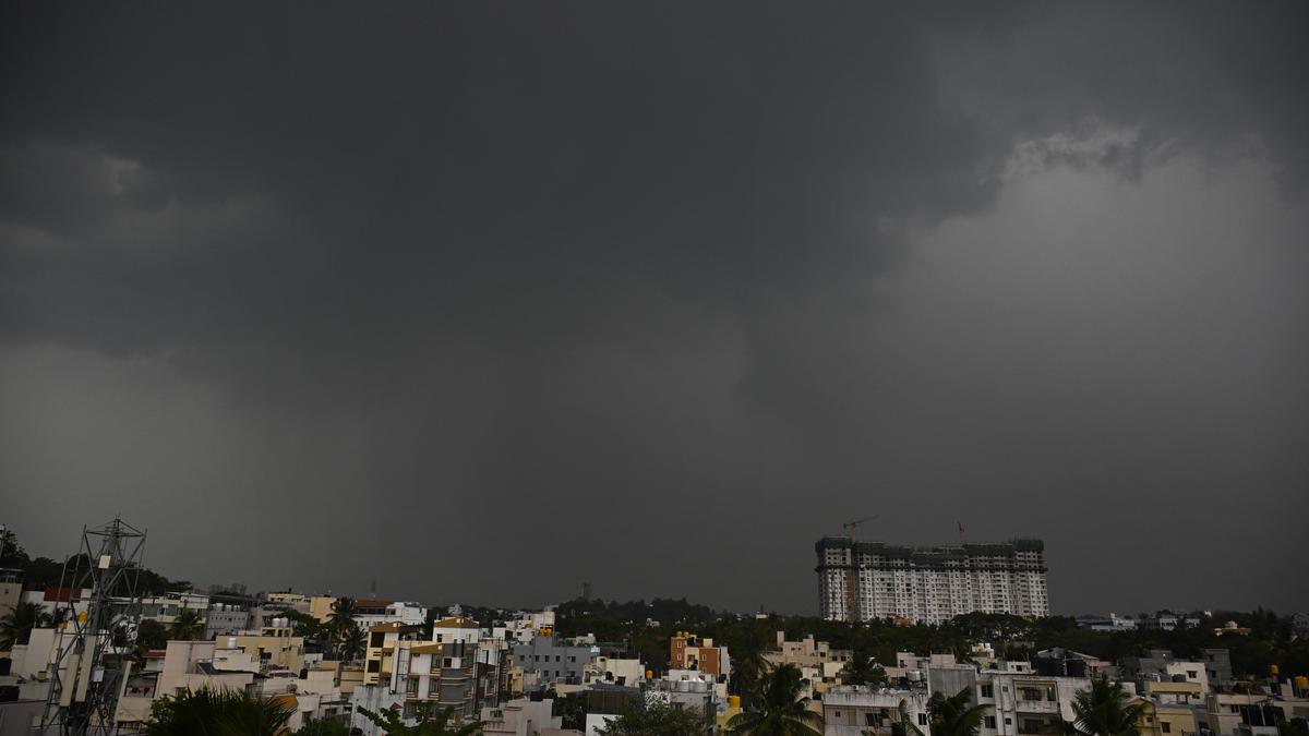
- 01 Apr 2025
In News:
A recent study by the Indian Institute of Science (IISc) has shed new light on the role of equatorial cloud bands in determining the movement and intensity of monsoon rainfall over India. These insights could enhance the accuracy of seasonal and sub-seasonal climate models.
Key Findings of the Study:
- Importance of Cloud Band Strength:
- The northward movement of monsoon cloud bands—crucial for triggering wet spells in India—is not guaranteed. Only strong cloud bands originating near the equator successfully propagate northward.
- Weak cloud bands fail to initiate wet spells, countering earlier assumptions that all cloud bands move north regardless of strength.
- Role of BSISO:
- The Boreal Summer Intraseasonal Oscillation (BSISO) governs alternating wet and dry spells during the monsoon. It helps transport convection (cloud activity and heat) from the Indian Ocean towards the Indian subcontinent.
- The size and strength of the cloud band influenced by BSISO determine the duration and intensity of wet phases.
- Air-Sea Interaction:
- Moisture buildup and wind strength, both vital for rain formation, are heavily influenced by air-sea interaction in the equatorial Indian Ocean.
- Strong coupling between the ocean and atmosphere enhances atmospheric moisture, aiding cloud formation and monsoon intensity.
- Impact of Climate Change:
- With rising global temperatures, background atmospheric moisture is expected to increase.
- This is projected to lead to a 42%–63% rise in rainfall during wet spells across India and surrounding seas in the future.
- Modeling and Forecasting:
- The study's findings help address gaps in current climate models, improving forecasts for monsoon rains at both seasonal and sub-seasonal scales.
What is BSISO?
- A large-scale monsoon phenomenon active between June and September.
- Alternates between active (rainy) and break (dry) spells.
- Modulated by global oceanic phenomena such as:
- El Niño: Weakens northward propagation of BSISO.
- La Niña: Enhances BSISO movement towards India.
Key Facts About Indian Monsoon:
- Monsoon Etymology: Derived from Arabic "mausim", meaning season.
Types of Monsoons in India:
- Southwest Monsoon (June–September):
- Also called the advancing monsoon.
- Brings 80% of India's annual rainfall.
- Driven by low pressure over the Indian subcontinent and high pressure over the Indian Ocean.
- Northeast Monsoon (October–December):
- Known as the retreating monsoon.
- Affects southeastern coastal regions, especially Tamil Nadu and Andhra Pradesh.
Key Influencing Factors:
- Inter-Tropical Convergence Zone (ITCZ): Moves northward in summer, attracting moisture-laden winds.
- Tibetan Plateau Heating: Generates the Tropical Easterly Jet, enhancing monsoon inflow.
- Somali Jet: Strengthens monsoon winds from the Arabian Sea.
- Indian Ocean Dipole (IOD):
- Positive IOD (warmer west): Enhances monsoon.
- Negative IOD (warmer east): Weakens it.
- ENSO (El Niño–Southern Oscillation):
- El Niño: Linked with weaker monsoons and droughts.
- La Niña: Associated with stronger and prolonged monsoon spells.
Maasai Tribe and the Carbon Credit Conflict in Tanzania
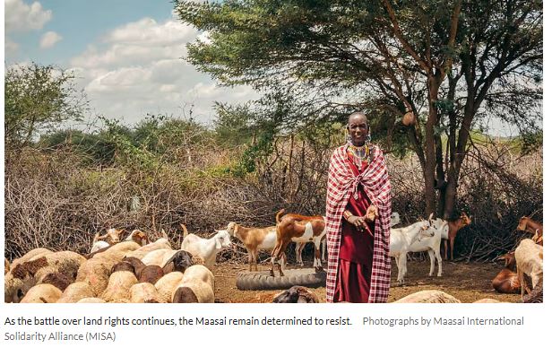
- 01 Apr 2025
In News:
The Maasai, a prominent indigenous community in East Africa, are resisting international carbon credit projects in Tanzania. They fear these initiatives may lead to land dispossession and the erosion of their traditional pastoralist lifestyle.
Who are the Maasai?
- Ethnic Group: Semi-nomadic pastoralists found primarily in Tanzania and Kenya, especially in the Great Rift Valley and semi-arid savannas.
- Language:Maa (Eastern Sudanic branch, Nilo-Saharan family).
- Cultural Identity:
- Known for distinct attire, beadwork, and warrior traditions.
- Socially organized through patrilineal clans, divided into moieties and age-sets (from junior warriors to senior elders).
- Youth (Morans) undergo bush training for resilience and discipline.
- Livelihood:
- Rely on cattle, sheep, and goats for milk, meat, and blood.
- Practice transhumance, moving seasonally for water and pasture.
- Reside in kraals—circular enclosures with mud-dung houses and thorn fences.
Carbon Credit Projects and Rising Tensions
- Projects Involved:
- Longido and Monduli Rangelands Carbon Project (Volkswagen ClimatePartners).
- Resilient Tarangire Ecosystem Project (The Nature Conservancy).
- Area Affected: Nearly 2 million hectares of Maasai grazing land.
- Project Goal: Store soil carbon and sell offsets to polluters globally.
Maasai Concerns and Resistance
- Forced Land-Use Changes:Carbon projects impose structured rotational grazing (e.g., 14-day grazing cycles), disrupting centuries-old mobility practices.
- Lack of Consultation:Research by the Maasai International Solidarity Alliance (MISA) shows widespread violations of Free, Prior, and Informed Consent (FPIC).
- Women and youth were excluded from consultations.
- Some communities unknowingly entered 30–40 year contracts.
- Payments were often tokenistic and poorly explained.
- Economic and Legal Risks:
- Villages lack clarity on revenue shares from credits.
- Contracts lock communities into rigid systems despite village land-use plans being reviewed every 10 years.
- Intermediaries—not end buyers—dominate the agreements.
Government and Global Dimensions
- Tanzania’s Push:The government expects $1 billion/year from carbon credit sales and is streamlining the sector through the National Carbon Monitoring Centre (NCMC).
- Global Scrutiny:
- Investigations reveal over 90% of rainforest offsets by some certifiers are ineffective.
- Soil carbon in semi-arid areas (like Maasai rangelands) is volatile and hard to quantify.
Grassroots Resistance and Legal Action
- Cultural and Spiritual Attachment:Land is integral to Maasai identity, beyond livestock rearing—it holds spiritual and cultural significance.
- Legal Mobilization:Young warriors, once defending livestock from predators, now advocate legally to protect ancestral land.MISA, formed after violent evictions in 2022 (Ngorongoro, Loliondo), spearheads resistance against exploitative schemes.
Mount Kenya’s Rapid Glacier Retreat due to Climate Change
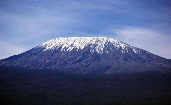
- 01 Apr 2025
In News:
Mount Kenya, Africa’s second-highest peak after Kilimanjaro, is witnessing a dramatic loss of its glacial cover due to accelerating climate change. Scientists warn that the mountain may become completely ice-free by 2030.
Key Findings:
- The Lewis Glacier, once one of the most prominent ice bodies on Mount Kenya, has experienced substantial shrinkage.
- A 2011 study by the University of Innsbruck (Austria) reported a 90% volume loss in Lewis Glacier between 1934 and 2010.
- A 2023 satellite analysis revealed that only 4.2% of the ice present in 1900 remains today.
About Mount Kenya:
- Location: Central Kenya, just south of the Equator.
- Elevation:5,199 meters (17,058 feet) at its highest peak, Batian.
- Geological Nature: An extinct stratovolcano, heavily eroded over millennia.
- Glaciers: Includes Lewis Glacier and Tyndall Glacier, among the last surviving tropical glaciers in Africa.
- UNESCO Status: Declared a World Heritage Site in 1997 for its ecological and cultural value.
National Centre for Polar and Ocean Research (NCPOR)
- 24 May 2025
In News:
To mark its 25th anniversary, the Union Minister of Earth Sciences inaugurated two landmark facilities—Polar Bhavan and Sagar Bhavan—at the NCPOR campus in Vasco da Gama, Goa.
About NCPOR
- Established: 25 May 1998 (originally as the National Centre for Antarctic and Ocean Research – NCAOR).
- Status: Autonomous R&D institute under the Ministry of Earth Sciences (MoES).
- Headquarters: Vasco da Gama, Goa.
- Governing Body: Includes 13 members; the Secretary of MoES serves as the ex-officio Chairman.
Mandate and Key Functions
- Polar Research Leadership:
- Manages India's scientific stations:
- Antarctica: Maitri and Bharati
- Arctic: Himadri
- Himalayas: Himansh
- Coordinates India’s Antarctic, Arctic, Southern Ocean, and Himalayan expeditions.
- Manages India's scientific stations:
- Oceanic Research:
- Implements projects under the Deep Ocean Mission.
- Conducts Exclusive Economic Zone (EEZ) mapping and continental shelf surveys.
- Explores deep-sea minerals, gas hydrates, and metal sulphides.
- Policy Implementation:
- Supports India’s Arctic Policy (2022) and Indian Antarctic Act (2022):
- Antarctic Act: Provides legal framework for governance and environmental protection via CAG-EP (Committee on Antarctic Governance and Environmental Protection).
- Arctic Policy: Based on six pillars—science, environment, development, connectivity, governance, and capacity building.
- Supports India’s Arctic Policy (2022) and Indian Antarctic Act (2022):
- Scientific Logistics and Collaboration:
- Operates research vessels (e.g., ORV Sagar Kanya).
- Engages in international polar networks and climate monitoring programs.
- Maintains India’s Antarctic Data Centre and conducts climate modelling.
New Facilities at NCPOR
Polar Bhavan:
- Area: 11,378 sq. m | Cost: ?55 crore
- Features:
- Advanced polar and ocean research laboratories
- Science on Sphere (SOS) 3D visualization platform
- Accommodation for 55 scientists
- Conference halls, library
- Home to India’s first Polar and Ocean Museum
Sagar Bhavan:
- Area: 1,772 sq. m | Cost: ?13 crore
- Features:
- Two -30°C ice core laboratories
- +4°C storage units for biological and sediment samples
- Class 1000 clean room for trace metal and isotope studies
Significance for India
- Strengthens India’s strategic presence in polar regions.
- Enhances research capacity in ocean and climate sciences.
- Enables India to fulfill international obligations under polar treaties.
- Promotes science diplomacy and public outreach through the upcoming museum.
Weather Balloons and Global Forecasting Concerns

- 24 May 2025
Background:
Weather balloons, crucial for upper atmospheric observations, are facing reduced deployment in the United States due to recent budget cuts. The National Oceanic and Atmospheric Administration (NOAA) has significantly scaled back balloon launches since March 2025 following a 25% budget reduction. This has raised global concerns among meteorologists over the potential decline in forecast accuracy.
What are Weather Balloons?
- Inventor: Léon Teisserenc de Bort (France), first launched them in 1896; discovered the tropopause and stratosphere.
- Composition: Latex balloons filled with helium or hydrogen.
- Altitude: Can ascend up to 1,15,000 feet (35 km) in approximately 2 hours.
- Instrument Carried: Radiosonde – a small device suspended ~66 feet below the balloon that transmits real-time atmospheric data (temperature, pressure, humidity, wind) via radio signals.
- Technology: Modern radiosondes are lightweight, GPS-enabled, and energy-efficient.
Historical Context:
- Initial upper-air measurements in the 18th century used kites with meteorographs.
- Weather balloons replaced kites due to higher altitude capability and improved data reliability.
- The introduction of radiosondes in the 1930s revolutionized weather forecasting by enabling real-time data transmission.
Importance of Upper Air Observations
- Upper atmosphere (>5,000 feet) plays a vital role in generating surface-level weather conditions like rain, storms, and drought.
- Weather balloons help bridge the data gap between surface stations and satellites by offering vertical atmospheric profiles.
- Twice-daily launches at 0000 UTC and 1200 UTC (~5:30 AM and 5:30 PM IST) are globally coordinated at over 900 stations, including 56 in India.
India’s Scenario
- The India Meteorological Department (IMD) conducts routine balloon launches for weather forecasting.
- The National Balloon Facility (NBF) in Hyderabad, jointly managed by ISRO and TIFR, supports high-altitude atmospheric research.
Impact of Reduced Launches
- NOAA’s scaling down has sparked fears of reduced forecast accuracy globally.
- A similar move by Russia in 2015 led to a measurable decline in forecast quality across Europe, highlighting the critical role radiosondes play.
- NOAA plans to replace some balloon data with AI-powered alternatives developed by private firms to reduce costs.
Why Weather Balloons Still Matter in the Satellite Era
- Satellites provide large-scale imagery but lack the granularity of vertical atmospheric data.
- Weather balloons offer crucial insights into lower- and mid-atmospheric layers where storms and climate dynamics form.
- Radiosonde data is essential for calibrating satellite measurements, ensuring reliability in climate modeling and forecasting systems.
Blue Talks

- 23 May 2025
In News:
Recently, India successfully hosted the Second Blue Talks in New Delhi, organised by the Ministry of Earth Sciences (MoES) in collaboration with the Embassies of France and Costa Rica. This high-level consultation platform aims to contribute to the upcoming 3rd United Nations Ocean Conference (UNOC3) scheduled from June 9–13, 2025 in Nice, France.
About Blue Talks
- Purpose: A multilateral platform for dialogue among governments, scientists, civil society, and stakeholders to promote the sustainable use of ocean resources and accelerate progress on Sustainable Development Goal (SDG) 14 – Life Below Water.
- Key Objectives:
- Promote marine sustainability, research, and education.
- Facilitate global scientific cooperation on ocean-related challenges.
- Share best practices and strategic knowledge tools.
- Strengthen consensus and policy alignment in the lead-up to UNOC3.
- Thematic Focus Areas of 2nd Blue Talks:
- Conservation and Restoration of Marine and Coastal Ecosystems.
- Scientific Cooperation, Marine Technology, and Ocean Literacy.
- Reduction of Marine Pollution from land and sea-based sources.
- Interlinkages among Oceans, Climate, and Biodiversity.
Highlights of the Event:
- White Paper Released: Transforming India’s Blue Economy: Investment, Innovation, and Sustainable Growth.
- Aim: To align government action, mobilize investments, and promote sustainable ocean development.
- Notable Themes:
- Mapping of marine resources.
- Promotion of offshore wind and deep-sea exploration.
- Technology and data-sharing gaps.
- Women-led seaweed farming, smart ports, and green ship recycling as success models.
About the 3rd United Nations Ocean Conference (UNOC3)
Feature Details
Host Countries France and Costa Rica
Venue & Dates Nice, France; June 9–13, 2025
Organiser United Nations
Theme “Accelerating action and mobilizing all actors to conserve and
sustainably use the ocean.”
Goal Strengthen global efforts under SDG 14
Key Outcome Nice Ocean Action Plan – a non-binding but politically influential declaration.
Focus Areas Marine conservation, pollution reduction, global partnerships, and
BBNJ ratification.
UN Ocean Conference Series
- 1st UNOC (2017): New York, USA – Raised awareness and voluntary commitments.
- 2nd UNOC (2022): Lisbon, Portugal – Focused on innovation and science-driven approaches.
- 3rd UNOC (2025): Nice, France – Aims to intensify action and collaboration.
India’s Blue Economy Vision
- India's Blue Economy is a critical pillar of the Viksit Bharat 2047 vision.
- MoES is the nodal agency for national ocean governance.
- The white paper integrates efforts from 25 ministries and all coastal states/UTs.
- Builds on India’s G20 Presidency and Chennai High-Level Principles for a Sustainable and Resilient Blue Economy.
Sakurajima Volcano Eruption
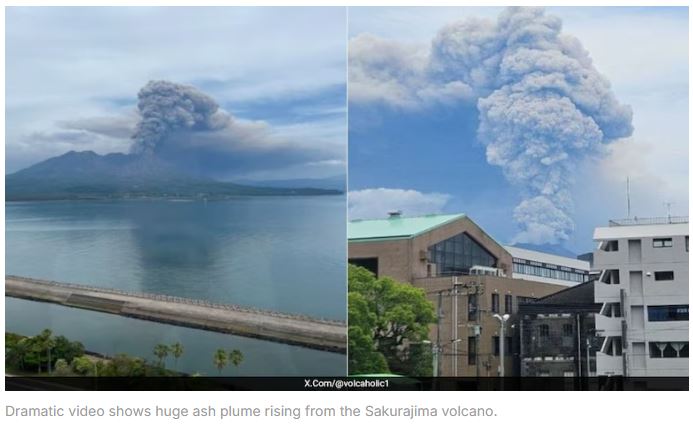
- 17 May 2025
In News:
Japan’s Sakurajima volcano, located in Kagoshima Prefecture on the southern island of Kyushu, recently erupted sending a dense ash plume 3,000 metres into the sky. The eruption originated from the Minamidake summit crater and was accompanied by a Level 3 volcanic alert, advising people to stay away from the vicinity.
Key Features of Sakurajima Volcano:
- Type: Stratovolcano (composite volcano)
- Geological Setting: Situated on a convergent plate boundary, formed from subduction-related volcanic activity.
- Structure: Comprises North Peak and South Peak, and lies on the southwestern rim of the Aira Caldera.
- Historical Significance: Was an island until the 1914 eruption, which connected it to the ?sumi Peninsula.
- Frequent Activity: One of Japan's most active volcanoes, experiencing daily minor eruptions and emitting continuous volcanic smoke.
Volcanic Characteristics:
- Lava Type:Andesitic – high in gas content and viscosity, leading to explosive eruptions.
- Hazards: Produces ash fall, pyroclastic flows, volcanic bombs, and toxic gases.
- Proximity to Populated Areas: Only 4 km from Kagoshima City, making it a high-risk volcano with strict monitoring by the Japan Meteorological Agency (JMA).
Impact and Preparedness:
- No injuries or major damages have been reported as of now.
- Ash fall warnings were issued for Kagoshima, Kumamoto, and Miyazaki prefectures.
- The eruption highlights Japan’s robust disaster preparedness and early warning systems, essential due to the country's location on the Pacific Ring of Fire.
Shear-Wave Splitting
- 06 May 2025
In News:
Scientists from the University of Oxford have proposed a new method to monitor volcanic eruptions by using the seismic phenomenon of shear-wave splitting, demonstrated at Mount Ontake in Japan.
What is Shear-Wave Splitting?
- Shear-wave splitting is a seismic phenomenon where shear (S) waves split into two components that travel at different speeds based on their polarisation.
- Occurs when waves pass through aligned cracks or fractures in subsurface rocks.
- Movement of magma and volcanic fluids changes stress conditions, causing rock cracks to open or close.
- These changes influence the speed and direction of shear waves.
- Increased shear-wave splitting can indicate rising internal pressure, serving as a potential early warning for volcanic eruptions.
Mount Ontake – Key Facts
- Type: Active stratovolcano
- Location: Honsh? Island, Central Japan, near Tokyo
- Status: Japan’s second-highest volcano
- Part of the Pacific Ring of Fire
- Major Eruption:
- Year: 2014
- Type: Phreatic eruption (steam-driven)
- Casualties: 60+ people, mainly hikers
- Notably occurred without significant seismic warning
- Phreatic Eruptions:
- Caused by steam pressure from heated underground water
- Do not involve new magma
- Difficult to predict using conventional methods
IISc Study on Monsoon Cloud Bands and Rainfall Intensity
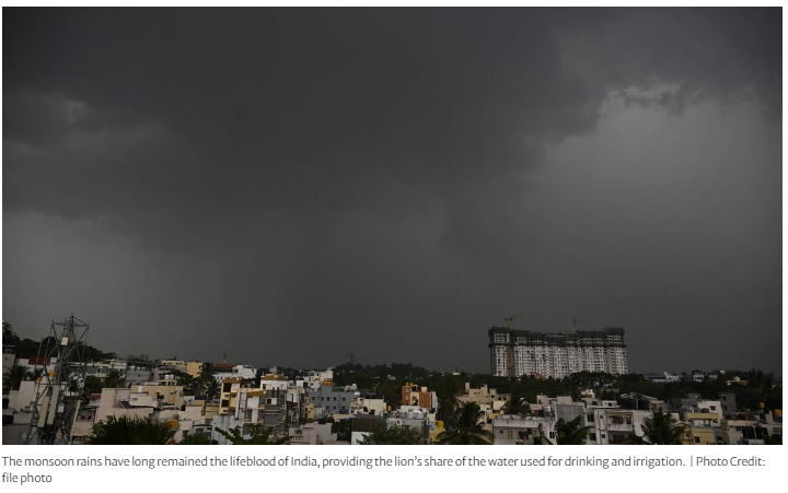
- 28 Mar 2025
In News:
A recent study by the Indian Institute of Science (IISc) has challenged the conventional understanding of monsoon dynamics by highlighting the critical role of cloud band strength in determining the movement and intensity of rainfall during the Indian monsoon season.
Key Findings of the Study:
- Strength Determines Propagation: Only strong equatorial cloud bands are capable of northward movement, initiating wet spells over the Indian subcontinent. Weak cloud bands fail to propagate, contradicting earlier models that assumed uniform northward movement.
- Role of BSISO: The Boreal Summer Intraseasonal Oscillation (BSISO) governs alternating wet and dry spells by transporting cloud bands from the equator to India. The duration and intensity of wet spells are influenced by the size and strength of these cloud bands.
- Air-Sea Interaction: Interaction between the equatorial Indian Ocean’s sea surface and atmosphere significantly influences moisture buildup and wind strength. A stronger ocean-atmosphere coupling enhances moisture transport, intensifying the monsoon.
- Impact of Climate Change:
- Warmer atmosphere → Increased background moisture.
- Future wet spells may see 42%–63% more rainfall over India and adjoining seas.
- Improving Forecast Models: These insights will enhance the accuracy of seasonal and sub-seasonal monsoon prediction models, crucial for agriculture and disaster preparedness.
Understanding BSISO (Boreal Summer Intraseasonal Oscillation)
- A dominant monsoon variability pattern active from June to September.
- Modulates ‘active’ (rainy) and ‘break’ (dry) phases of the monsoon.
- Moves cloud activity and convection from the Indian Ocean towards the Western Pacific.
- ENSO link:
- La Niña enhances BSISO propagation → stronger monsoon.
- El Niño suppresses it → weaker monsoon.
Key Facts about the Indian Monsoon
Aspect Details
Definition “Monsoon” comes from Arabic mausim meaning season.
Southwest Monsoon June–September; moist winds from Indian Ocean bring ~80% of India’s
annual rainfall.
Northeast Monsoon October–December; brings rain to Tamil Nadu, coastal Andhra Pradesh.
Key Drivers ITCZ shift, Tibetan heating, Tropical Easterly Jet, Somali Jet.
Oceanic Influences IOD (positive enhances, negative weakens monsoon), ENSO (El Niño
weakens,La Niña strengthens monsoon).
Monsoon Importance Critical for agriculture, water supply, economy; affects ~50% of India’s
population directly.
Urban Heat Island Effect in Hyderabad

- 25 Mar 2025
In News:
The Telangana Socio-Economic Outlook 2025 highlights a concerning rise in night-time temperatures in Hyderabad, attributed to the Urban Heat Island (UHI) effect. This growing urban microclimatic issue has critical public health and environmental implications.
What is Urban Heat Island (UHI)?
- Definition: UHI is a climatic phenomenon where urban areas record significantly higher temperatures than surrounding rural or peri-urban regions, particularly at night.
- Cause: Result of urbanization and human activities that alter land surfaces and trap heat.
Key Factors Contributing to UHI
- Reduced green cover: Shrinking vegetation limits natural cooling via shade and evapotranspiration.
- High density of concrete structures: Buildings and roads absorb solar radiation during the day and release heat slowly at night.
- Urban layout: Tall buildings and narrow streets trap warm air, reducing air circulation.
- Anthropogenic heat: Emissions from vehicles, air conditioners, and industries contribute to localized warming.
- Surface characteristics: Dark tarred roads absorb more heat and release it at night, worsening night-time UHI.
Hyderabad Case Study: Telangana Socio-Economic Outlook 2025
- Temperature Difference:
- Night-time: Core city is 1.9°C warmer than surrounding peri-urban and outer zones.
- Daytime: Interestingly, the core is 0.7°C cooler due to shade from tall buildings.
- Peak UHI Season: March to August.
- Most Affected Zones: High-rise, concrete-dense city centers with low vegetation.
Health Impacts of UHI
According to medical experts:
- Physical Effects:
- Heat exhaustion & heat strokes
- Dehydration, skin issues
- Cardiovascular and kidney stress
- Vulnerable Groups: Elderly, children, and those with pre-existing conditions.
- Biological Mechanism: Prolonged exposure increases pro-inflammatory cytokines, leading to immune suppression and chronic fatigue.
- Mental Health: UHI contributes to sleep disturbances, psychological stress, and anxiety.
Government Response
- Clean and Green Energy Policy 2025: Telangana aims to promote cooler, greener cities.
- Recommended Actions:
- Interdisciplinary collaboration among urban planners, healthcare professionals, and community experts.
- Urban design incorporating green infrastructure and heat-resilient materials.
Mount Erebus
- 10 Mar 2025
In News:
- Volcanic ice caves beneath Mount Erebus host thriving microbial life, offering insights into extremophile survival and potential life on alien planets.
About Mount Erebus:
- Location: Ross Island, Antarctica, in the Ross Sea.
- Type:Glaciated intraplate stratovolcano; part of the Pacific Ring of Fire.
- Altitude:3,794 meters (12,448 feet) above sea level.
- Rank:Second tallest volcano in Antarctica (after Mount Sidley).
- Discovered: In 1841 by British explorer Sir James Clark Ross.
- Name Origin: Named after Ross’s ship, HMS Erebus.
Volcanic Activity:
- Southernmost active volcano on Earth.
- Continuously active since 1972.
- Eruptions are Strombolian in nature — small, explosive, with lava bombs ejected onto crater rim.
- Contains a persistent lava lake with alkalic lava, typical of rift volcanoes.
Proximity to Human Activity:
- Near McMurdo Station, the largest Antarctic research base, just ~40 km away.
Scientific Significance:
- The microbial ecosystems in volcanic ice caves could help understand:
- Life in extreme environments
- Astrobiological prospects on Mars or Europa
Zagros Mountains and Iraq’s Tectonic Subsidence
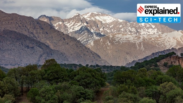
- 27 Feb 2025
In News:
Recent geological studies have found that the hilly region around the Zagros Mountains in northern Iraq is slowly sinking into the Earth, a process attributed to ancient tectonic dynamics. This discovery has implications for earthquake prediction and geothermal energy potential.
Zagros Mountains
- Location: Stretches ~1,500 km from eastern Turkey and northern Iraq across the Iranian Plateau to the Strait of Hormuz.
- Highest Peak: Mount Dena (4,409 m / 14,465 ft).
- Geological Composition: Primarily limestone and shale from the Mesozoic Era and Paleogene Period.
- Climate: Semi-arid temperate – cold winters and dry, arid summers.
- Vegetation: Dominated by oak and pistachio trees with steppe vegetation.
Geological Process Behind Iraq’s Sinking
- The Zagros region is influenced by the tectonic collision between the Arabian and Eurasian Plates.
- A sinking oceanic slab, part of the ancient Neotethys Ocean floor (over 66 million years old), is pulling the region down.
- This slab is subducting beneath the Eurasian Plate, a process occurring over tens of millions of years, making it imperceptible in human timescales.
Research Insights
- The studyused rock records, sediment analysis, and deep-earth imaging to understand the tectonic architecture of the region.
- The findings explain why the depressions around the Zagros Mountains are deeper than the current topography would suggest.
Significance of the Study
- Helps develop precise geological models critical for:
- Earthquake prediction – by understanding fault depths and configurations.
- Geothermal energy exploration – estimating areas with high geothermal gradients.
- Especially relevant in a region prone to seismic activity (e.g., 2023 Turkey-Syria earthquakes).
Mount Etna Eruption 2025
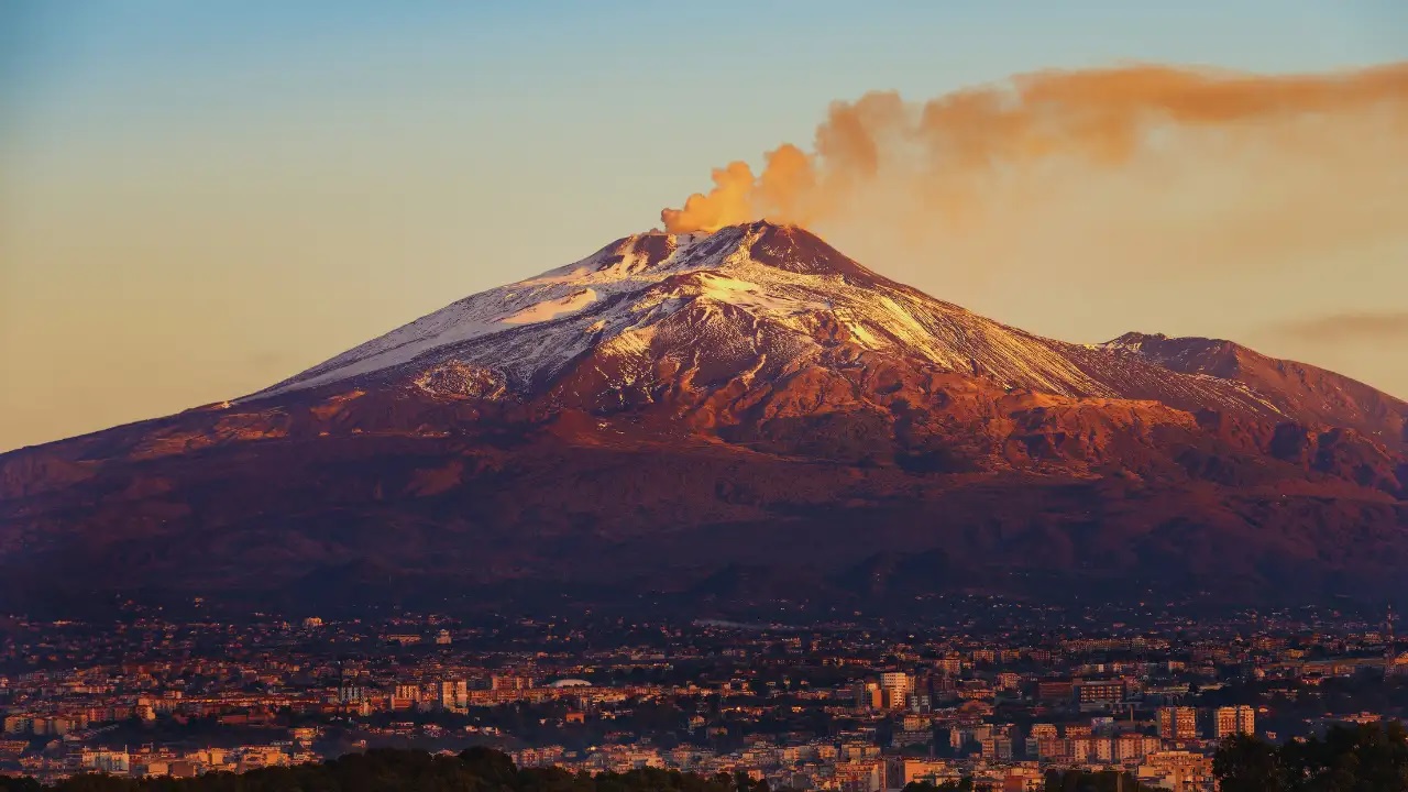
- 18 Feb 2025
In News:
On February 12, 2025, Mount Etna, Europe's tallest and most active volcano, erupted once again, spewing lava flows and dense ash clouds into the atmosphere. The event drew attention not just due to its visual spectacle, but also because of the geological, environmental, and socio-economic implications it carries.
About Mount Etna
- Location: Eastern coast of Sicily, Italy — the largest island in the Mediterranean Sea.
- Type:Active stratovolcano, known for frequent eruptions.
- Height & Size: Highest peak south of the Alps and tallest active volcano in Europe; rises over 3,300 meters and covers 1,190 sq. km with a basal circumference of 140 km.
- Tectonic Setting: Lies above the convergent boundary of the African and Eurasian tectonic plates, making it a hotspot for seismic and volcanic activity.
- Eruption History: Recorded to have erupted over 200 times since 1500 BCE, with persistent volcanic activity.
- UNESCO Recognition: Declared a UNESCO World Heritage Site in 2013 for its exceptional geological features, cultural relevance, and continuous scientific monitoring.
- Decade Volcano Status: Designated a Decade Volcano by the United Nations due to its proximity to densely populated areas, including the city of Catania, and the potential risk it poses, warranting special scientific attention.
FulaniCommunity

- 17 Feb 2025
In News:
The Fulani, one of Africa’s largest and most dispersed ethnic communities, trace their ancestry to the ‘Green Sahara’ period (12,000–5,000 years ago), according to recent genetic and anthropological research. This period, when the Sahara was a fertile, habitable landscape, marks the early development of African pastoralism.
The Fulani population is estimated at 40 million, spread across West and Central Africa, from Senegal and Guinea in the west to Lake Chad in the east. They are particularly concentrated in Nigeria, Mali, Guinea, Senegal, and Niger, and inhabit the Sahel-Savannah belt, straddling arid and semi-arid regions.
Nomadic Lifestyle and Social Structure
Traditionally known for their nomadic pastoralism, the Fulani have maintained a unique socio-cultural identity despite centuries of migration and contact with other African populations. Their society is internally diverse, divided into three main groups:
- Makiyaya: Nomadic herders
- FulaninSoro: Town dwellers
- Bararo: Forest dwellers, with strong ties to ancestral rituals and nature-based belief systems
Fulani communities are largely egalitarian, with a deep emphasis on kinship, family structure, and communal responsibility. Polygamy is widely practiced, and marriage ceremonies are elaborate, often involving intricate rituals and festive celebrations.
Women’s Role and Cultural Expression
Fulani women are recognized for their weaving, artisanal craftsmanship, and particularly their hairstyles, which are often elaborately styled and adorned with beads and cowrie shells—symbols of both identity and aesthetic tradition.
Linguistic and Religious Identity
The Fulani speak Fula (also called Fulfulde or Pulaar), a language belonging to the Atlantic branch of the Niger-Congo language family. Though largely Muslim, many retain spiritual connections with nature-based traditions, particularly among the Bararo groups.
Genetic Heritage and Historical Significance
A recent multinational study led by Uppsala University and Charles University analyzed biological and anthropological data from 460 Fulani individuals across 18 locations in seven African countries. It confirmed a complex genetic history, shaped by:
- Ancient North African ancestry, particularly linked to populations akin to modern-day Berbers of Morocco
- Historical interactions with West, Central, and East African communities
- A shared ancestral genetic component, likely rooted in early pastoral communities of the Green Sahara era
The research underscores that despite their high mobility and limited archaeological footprint, the Fulani have preserved a distinct genetic and cultural identity for millennia.
Cayman Islands
- 12 Feb 2025
In News:
A magnitude 7.6 earthquake recently struck the Caribbean Sea southwest of the Cayman Islands, as reported by the U.S. Geological Survey. While no tsunami warning was issued, tremors were felt across the region, and assessments of damage are ongoing.
Geographical and Geopolitical Overview
- The Cayman Islands is a British Overseas Territory located in the western Caribbean Sea, south of Cuba and northwest of Jamaica.
- It comprises three islands:
- Grand Cayman (largest and most populous)
- Cayman Brac
- Little Cayman
- The islands are part of the Cayman Ridge, an underwater mountain range, with the islands themselves being the emergent peaks of this ridgeline.
- Area: Only 264 sq. km
- Capital: George Town, located on Grand Cayman
- Official Language: English
- Currency: Cayman Islands Dollar (KYD)
- Ethnic Composition:
- Afro-European: 40%
- African: 20%
- European: 20%
- Other: 20%
Seismic and Climatic Features
- The islands are near the Cayman Trench, a deep subduction zone formed by the interaction between the North American and Caribbean Plates.
- Although major earthquakes are rare, the region is seismically active, and moderate to high seismic events are possible, such as the recent 7.6 magnitude quake.
- Climate: Tropical marine with a distinct wet and dry season; vulnerable to hurricanes, especially during the Atlantic hurricane season (June–November).
Ecological Significance
- Known for crystal-clear waters, coral reefs, and white sand beaches, the Cayman Islands are a global hub for marine biodiversity.
- Key ecological features include:
- Coral reefs, seagrass beds, and mangroves
- Famous dive sites like the Great Blue Hole and Bloody Bay Wall
- Terrestrial biodiversity is limited due to the islands’ small limestone-based land area, but they are home to endemic species such as the Grand Cayman Blue Iguana, which has recovered from critical endangerment through conservation efforts.
Economic Importance: A Global Financial Hub
- The Cayman Islands is renowned as a major offshore financial center and global tax haven.
- Zero taxation: No corporate, income, or capital gains tax
- Home to:
- Offshore banks
- Hedge funds
- Multinational corporations
- The islands offer a favorable regulatory environment and strict financial confidentiality laws, although they now comply with international transparency norms.
Mount Taranaki
- 08 Feb 2025
In News:
In a significant legal and environmental development, Mount Taranaki—officially now known by its M?ori name Taranaki Maunga—has been granted legal personhood by the government of New Zealand.
This move marks it as the third natural feature in the country to receive such status, following the Te Urewera National Park (2014) and the Whanganui River (2017).
This recognition reflects an increasing global trend toward acknowledging the intrinsic rights of natural entities and respecting the spiritual beliefs of indigenous communities.
About Taranaki Maunga
- Location: Situated in Egmont National Park, North Island, New Zealand.
- Dual Naming: Historically known as Mount Egmont, it is now officially referred to by its indigenous name, Taranaki Maunga, as part of decolonization and cultural revival efforts.
- Elevation: Stands at 8,261 feet, making it the second-highest peak in the North Island of New Zealand.
- Geological Type: It is a stratovolcano (composite cone) with a nearly perfect symmetrical shape—one of the most symmetrical volcanic cones in the world.
- Formation: Formed due to the subduction of the Pacific Plate beneath the Australian Plate. The magma source lies deeper than that of the Taupo Volcanic Zone volcanoes.
- Topography: Surrounded by a circular ring plain formed from lahars (volcanic mudflows) and landslides.
- Status: A snow-capped dormant volcano and culturally revered natural landmark.
- Cultural Significance: The M?ori, indigenous people of New Zealand, regard Taranaki Maunga as a sacred ancestor, embedding it deeply in their oral traditions and spirituality.
Legal Personhood and Its Significance
Granting legal personhood to Taranaki Maunga means it now holds rights, duties, and liabilities akin to a legal human being, and its interests will be represented by appointed guardians—often including indigenous representatives.
This legal framework recognizes:
- The spiritual and cultural relationship that the M?ori have with the mountain.
- The need to protect natural ecosystems not merely for utility but as living entities deserving of rights and dignity.
Comparative Insights: India’s Legal Approach to Natural Entities
India has witnessed similar developments:
- Uttarakhand High Court (2017–18): Granted legal personhood to the Ganga and Yamuna rivers, along with the Gangotri and Yamunotri glaciers. However, the Supreme Court later stayed this ruling.
- Punjab and Haryana High Court (2020): Recognized Sukhna Lake (Chandigarh) as a living entity for environmental protection.
- These decisions stem from the Doctrine of Parens Patriae, which allows the state to act as a guardian for those who cannot protect themselves—extending this protection to natural entities such as rivers, forests, and wildlife.
Ocean Coordination Mechanism (OCM)
- 02 Feb 2025
In News:
Recently, the Intergovernmental Oceanographic Commission of UNESCO (UNESCO-IOC) announced the signature of a Memorandum of Understanding (MoU) enabling the creation of the Ocean Coordination Mechanism (OCM).
What is the Ocean Coordination Mechanism (OCM)?
- It is a collaborative governance initiative aimed at the sustainable management of marine resources in the Caribbean and North Brazil Shelf region.
- Conceived under the 10-year CLME+ Strategic Action Programme (SAP)—endorsed in 2014—it represents a transformative step toward integrated ocean governance.
Key Objectives of OCM:
- Promote sustainable fisheries
- Advance ecosystem restoration and marine spatial planning
- Establish marine protected areas (MPAs)
- Encourage pollution control and blue carbon development
- Foster cross-country and cross-institutional cooperation
It builds on lessons from earlier efforts like the Pacific Islands Regional Ocean Policy (PIROP), aiming to avoid past pitfalls such as vague targets, lack of integration, and funding shortfalls.
Significance of the Caribbean and North Brazil Shelf Region:
- Coral reefs and fisheries contribute ~$610 million annually to local economies
- The North Brazil Shelf is home to over 500 fish species
- Acts as a natural barrier against storms, crucial for climate resilience
Blue Carbon and Climate Action:
The OCM promotes blue carbon projects that utilize coastal ecosystems (like mangroves and seagrasses) for carbon storage, enhancing climate resilience and providing livelihoods to local communities.
Funding Details:
- $15 million from Global Environment Facility (GEF) via the UNDP/GEF PROCARIBE+ Project (2024–2028)
- Additional $126.02 million in co-financing mobilized
- However, the funding is modest compared to initiatives like the Global Fund for Coral Reefs (targeting $3 billion by 2030), raising concerns about OCM's long-term financial sustainability.
Role of IOC-UNESCO:
Established in 1961, the IOC of UNESCO promotes international cooperation in ocean science and policy. Key functions include:
- Marine scientific research (climate, biodiversity, sustainability)
- Tsunami warning systems
- Oceanographic data collection and dissemination
- Leading the UN Ocean Decade (2021–2030) for global marine conservation
Why OCM Matters:
- Addresses the Ocean–Climate–Biodiversity nexus
- Aims to ensure equitable access to marine resources
- Prioritizes local and vulnerable communities
- Integrates traditional knowledge with scientific research for culturally inclusive conservation
Resumption of Kailash Mansarovar Yatra
- 29 Jan 2025
In News:
After a four-year hiatus due to the COVID-19 pandemic and the 2020 Galwan Valley clash, India and China have agreed to resume the Kailash Mansarovar Yatra in June 2025, along with other confidence-building measures.
This decision aligns with the 75th anniversary of India-China diplomatic relations, symbolizing an attempt to stabilize and recalibrate bilateral ties through people-centric initiatives.
Key Highlights:
Key announcements include:
- Resumption of the Kailash Mansarovar Yatra
- Restoration of direct air services
- Visa issuance for journalists and think tanks
- Hydrological data sharing and cooperation on trans-border rivers
- Enhanced people-to-people exchanges and academic/media dialogues
About the Yatra
- The Yatra involves a pilgrimage to Mount Kailash and Lake Mansarovar in the Tibetan Autonomous Region (Xizang).
- Organised by India’s Ministry of External Affairs between June–September, via two routes:
- Lipulekh Pass (Uttarakhand)
- Nathu La Pass (Sikkim)
- Supported by the state governments of Uttarakhand, Sikkim, and Delhi, and coordinated with the Indo-Tibetan Border Police.
- Open only to Indian citizens with valid passports; no financial subsidy is provided by the Government of India.
Geographical and Religious Significance:
- Mount Kailash, located in the Kailash Range (Transhimalaya), is the source of four major rivers: Sutlej, Brahmaputra, Indus, and Karnali.
- Revered across religions:
- Hindus consider it the abode of Lord Shiva; Mansarovar is one of the 51 Shaktipeeths.
- Buddhists and Tibetans regard it as the ‘Stairway to Heaven’.
- Jains believe Rishabhanatha attained enlightenment here—referred to as Ashtapada.
Diplomatic Interpretations and Differences
- India’s Position: Emphasized a step-by-step, cautious approach focusing on rebuilding trust and resolving contentious issues, particularly the border situation. India sought policy predictability and transparency in trade, and reaffirmed the importance of mutual respect and interests.
- China’s Position: Took a more optimistic and strategic stance, stressing the need to avoid "mutual suspicion" and to advance cooperation based on long-term national interests. It emphasized early action, including the swift resumption of the Yatra and flights.
Ongoing Concerns in Bilateral Relations
- Unresolved Border Disputes:
- Tensions persist along the Line of Actual Control (LAC)—notably in Galwan (2020) and Tawang (2022).
- India and China have made limited progress in resolving issues in Depsang and Demchok.
- Trade Imbalance:
- Bilateral trade in 2023–24 stood at USD 118.4 billion, with India facing a trade deficit of USD 85 billion.
- India raised concerns on market access and non-tariff barriers.
- China-Pakistan Axis:
- The China-Pakistan Economic Corridor (CPEC) runs through Pakistan-occupied Kashmir, violating India’s territorial sovereignty.
- China’s support for Pakistan in multilateral forums remains a thorn in bilateral ties.
- China’s Regional Assertiveness:
- Expanding influence in South Asia and the Indian Ocean through the String of Pearls, strategic presence in Maldives, Sri Lanka, and strong claims in the South China Sea, contribute to regional unease.
Significance of the Current Diplomatic Thaw
- The resumption of the Kailash Mansarovar Yatra reflects a symbolic softening in ties, emphasizing religious diplomacy and people-to-people connection.
- Restoration of direct flights and journalistic presence can aid in reducing mistrust.
- Hydrological cooperation, particularly over the Brahmaputra River, is essential for India’s water security, especially with China constructing mega-dams upstream.
Way Forward
- Rebuild Trust Through Engagement: Maintain diplomatic dialogues via platforms like BRICS, SCO, and G20, while holding to core national interests.
- Resolve Border Disputes: Pursue early finalization of the LAC through confidence-building agreements and military disengagement.
- Diversify Economic Strategy: Reduce dependency on Chinese imports by strengthening domestic manufacturing and regional trade alternatives.
- Enhance Cultural Diplomacy: Use platforms like the Kailash Yatra to foster mutual understanding rooted in shared civilizational values.
- Promote Transparency and Reciprocity: Especially in media, trade, and information sharing, to ensure balanced bilateral engagement.
PKC-ERCP: Rajasthan’s River-Linking Project
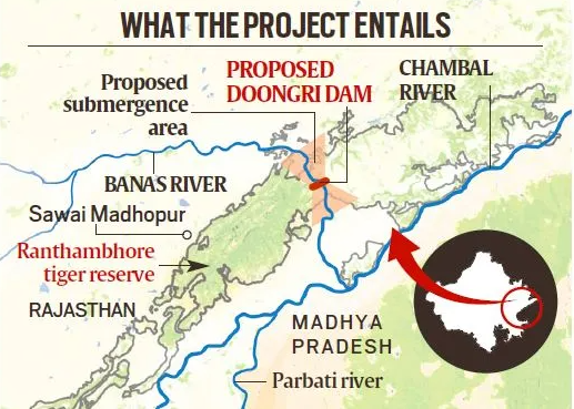
- 25 Jan 2025
In News:
The Parbati-Kalisindh-Chambal-Eastern Rajasthan Canal Project (PKC-ERCP), part of the National Interlinking of Rivers (ILR) programme, aims to address water scarcity in 23 districts of Rajasthan, potentially benefiting 3.45 crore people. However, it has raised serious concerns over its ecological impact, particularly on the Ranthambore Tiger Reserve.
About the PKC-ERCP Project:
Aspect Details
Objective To channel surplus water from the Chambal basin for irrigation, drinking, and industrial use in Rajasthan and Madhya Pradesh
Estimated Cost ?72,000 crore (90% funded by the Central Government)
Water Allocation 4,100 MCM to Rajasthan and 3,000 MCM to Madhya Pradesh
Rivers Involved Chambal, Parbati, Kalisindh, Banas, and tributaries
Major Structure 39 m high, 1.6 km long dam across the Banas River, a Chambal tributary, near Doongri village, ~30 km from Sawai Madhopur
Submergence and Environmental Concerns:
- Total Submergence: ~408.86 sq km in Rajasthan.
- Reservoir Impact: 227 sq km to be submerged under the proposed dam across Banas River.
- Impact on Tiger Reserve:
- 37.03 sq km of the Ranthambore Tiger Reserve (total area: 1,133 sq km) to be submerged.
- This includes parts of Ranthambore National Park (392 sq km) and Keladevi Wildlife Sanctuary (674 sq km).
- May fragment the reserve, disrupting wildlife corridors and tiger movement.
- Ranthambore’s Significance:
- Home to ~57 tigers, it is one of India’s most prominent conservation areas.
- Situated at the Aravalli-Vindhya junction, with rich biodiversity, including leopards, hyenas, sloth bears, and iconic flora like Dhok trees.
- Encompasses the UNESCO-listed Ranthambore Fort and the Great Boundary Fault.
Arguments For the Project:
- Addresses chronic water scarcity in eastern Rajasthan.
- Promotes agricultural productivity, drinking water security, and industrial development.
- Aims to optimize water use by diverting surplus flows.
Arguments Against the Project:
- Biodiversity loss due to habitat submergence and reserve fragmentation.
- Risks to tiger conservation efforts.
- Potential violation of environmental safeguards under the Wildlife Protection Act and Forest Conservation norms.
Long-term ecological costs may outweigh short-term developmental gains.
India’s Deep Ocean Mission

- 24 Jan 2025
In News:
India is set to deploy its first human-operated deep-sea submersible as part of the Deep Ocean Mission (DOM), marking a significant leap in the country’s marine research and technological capability.
Key Highlights:
- Submersible Deployment (2024):
- India will operate its first human submersible at a depth of 500 meters this year.
- The goal is to reach a depth of 6,000 meters by 2025.
- The project aligns with the timelines of Gaganyaan, India’s first human space mission—showcasing parallel progress in marine and space technology.
- Indigenous Technology:
- The mission is powered by 100% indigenous technology, underlining India’s growing self-reliance in high-end scientific infrastructure.
About Deep Ocean Mission (DOM):
- Launched: 2021
- Nodal Ministry: Ministry of Earth Sciences (MoES)
- Budget: ?4,077 crore over five years
- Framework: One of nine key missions under PM-STIAC (Prime Minister’s Science, Technology, and Innovation Advisory Council)
Core Objectives:
- Develop deep-sea technologies, including a manned submersible for ocean exploration.
- Explore and harness ocean resources such as: Polymetallic nodules, Hydrothermal sulphides & Rare earth metals
- Study marine biodiversity for sustainable fisheries and conservation.
- Support India’s blue economy through innovation and research.
- Monitor ocean climate change and develop advisory services.
- Promote marine biology and biotechnology via dedicated marine research stations.
- Harvest renewable energy and freshwater from ocean sources.
Key Components and Technologies:
Matsya6000 Submersible:
- India’s first manned deep-sea vehicle.
- Designed to reach 6,000 meters depth.
- Crew Capacity: Three members
- Developed by: National Institute of Ocean Technology (NIOT), Chennai
- Structure: Made of titanium alloy, withstanding 6,000 bar pressure
- Equipped with: Scientific sensors, tools for sampling, viewports, propellers, and acoustic communication systems.
- Combines capabilities of ROVs (Remotely Operated Vehicles) and AUVs (Autonomous Underwater Vehicles).
Varaha Deep-Ocean Mining System:
- Developed by NIOT
- Successfully conducted trials at 5,270 meters
- Key to India’s future in deep-sea mining of critical minerals
Strategic Importance:
- Scientific Advancement: DOM places India among a select group of nations (USA, Russia, China, France, Japan) with human-crewed deep-ocean exploration capacity.
- Economic Potential: Unlocks access to underwater mineral wealth, critical for electronics, defense, and energy sectors.
- Environmental Sustainability: Supports marine biodiversity conservation and promotes sustainable use of oceanic resources.
- Geopolitical Significance: Enhances India’s presence and influence in the Indian Ocean Region (IOR).
- Technological Leap: Strengthens India’s capabilities in underwater robotics, materials engineering, and ocean sciences.
Mount McKinley

- 22 Jan 2025
In News:
In a controversial move, President Donald Trump (2025) signed an executive order to rename Denali (North America’s highest peak) back to Mount McKinley, and also proposed renaming the Gulf of Mexico to the Gulf of America, citing the need to "honor American greatness."
About Denali / Mount McKinley:
Feature Description
Location Alaska Range, South-Central Alaska, USA
Height 20,310 feet (6,190 meters) – Highest in North America
Geology Giant granite block uplifted by tectonic activity ~60 million years ago
Glaciers Feeds major glaciers: Kahiltna, Muldrow, Peters, Ruth, Traleika
Tectonics Lies along the Denali Fault, a major right-lateral strike-slip fault
National Park Forms the core of Denali National Park and Preserve
Historical Background of the Name:
- Original Name: Denali, meaning “The High One” in the Athabascan language of the Koyukon people.
- 1897: Renamed Mount McKinley by a gold prospector in honor of President William McKinley (1897–1901).
- 1917: Official federal recognition with the creation of Mount McKinley National Park.
- 1980: Park renamed Denali National Park and Preserve; mountain's name remained McKinley federally.
- 2015: Obama administration officially renamed the peak Denali through the U.S. Department of the Interior.
- 2025: Trump issued executive order to revert the name to Mount McKinley, stating McKinley “deserves” the honor.
Rationale Behind Trump’s Renaming Order:
- Claims it honors McKinley’s legacy: economic growth, leadership in Spanish-American War, and tariff reforms.
- Declares Obama’s 2015 decision an “affront” to American heritage.
- Connects the move to his broader theme of “Restoring Names that Honor American Greatness.”
Opposition & Cultural Sensitivity:
- Alaska’s bipartisan leadership, including Senators Lisa Murkowski (R) and Scott Kawasaki (D), oppose the move.
- Indigenous groups maintain that Denali is the rightful and culturally authentic name.
- Critics argue it undermines native heritage and local identity.
Renaming the Gulf of Mexico to “Gulf of America”:
- Also part of Trump’s 2025 executive order.
- Geographic Facts:
- Borders the US, Mexico, and Cuba.
- Crucial to the US energy sector:
- 14% of US crude oil
- 5% of US natural gas
- 48% of refining capacity
- International Validity: The International Hydrographic Organization (IHO) allows local name usage but retains “Gulf of Mexico” in global records.
- Not binding on Mexico or Cuba.
International & Historical Parallels in Naming Disputes:
- Persian Gulf vs. Arabian Gulf (Iran vs. Arab states)
- Sea of Japan vs. East Sea (Japan vs. South Korea)
- South China Sea: Multiple nations claim different names and areas.
About the Denali Fault:
- Major strike-slip fault running through Alaska.
- Responsible for extensive tectonic movement and uplift of Denali.
- Evidence of horizontal displacement (~483 km) over millions of years.
- Marked the final suturing of tectonic plates in North American geological history.
Mount Ibu Eruption
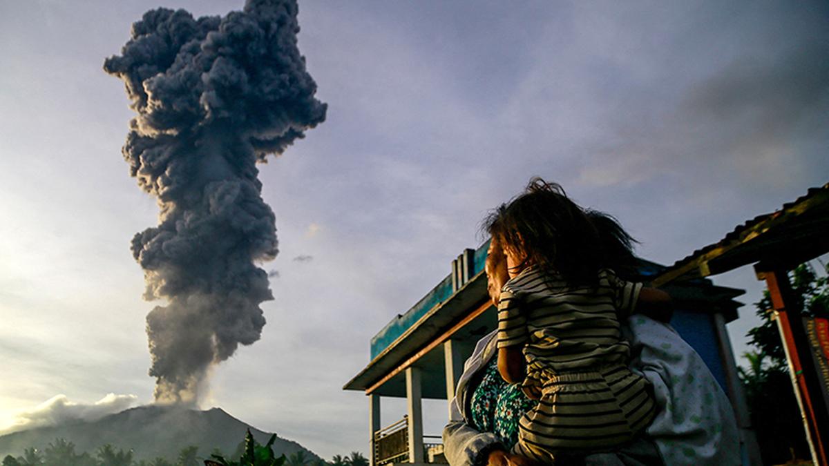
- 21 Jan 2025
In News:
Indonesia’s Mount Ibu erupted 1,000 times this month.
Overview:
- Location: Mount Ibu, Halmahera Island, North Maluku province, Indonesia.
- Volcano Type: Stratovolcano (composite volcano) – steep-sided, conical structure formed by successive layers of lava, ash, and pyroclastic material.
- Tectonic Setting: Located on the Pacific Ring of Fire, a major area of subduction zones with high volcanic and seismic activity.
Volcanic Context – Indonesia:
- Pacific Ring of Fire: Indonesia's location makes it one of the most volcanically active regions globally.
- Other Recent Eruptions:
- Mount Lewotobi Laki-Laki (twin-peaked volcano)
- Mount Ruang
- Both have shown heightened activity, triggering mass evacuations.
Indian Coffee Sector

- 21 Jan 2025
In News:
India is now the seventh-largest coffee producer globally with exports reaching $1.29 billion in FY 2023-24, almost double the $719.42 million in 2020-21.
Historical Background
- Origin: Coffee was introduced to India in the 17th century by Baba Budan, a Sufi saint, who brought seven Mocha beans from Yemen and planted them in Baba Budan Giri hills, Karnataka.
- This act laid the foundation for India’s coffee cultivation, which has since evolved into a robust agro-industry.
India’s Global Coffee Status
- 7th largest coffee producer globally (FY 2023–24).
- Exports: Reached $1.29 billion in FY 2023–24, nearly double the $719.42 million in FY 2020–21.
- Major export destinations: Italy, Belgium, Russia.
- Export Share: Over 70% of India's coffee is exported, mostly in unroasted (green bean) form.
Types of Coffee Cultivated
- Arabica: Mild flavor, higher market value.
- Robusta: Strong flavor, more robust; often used in instant coffee.
- India's production: Around 75% is a mix of Arabica and Robusta.
Geographical Distribution
- Major Coffee-Growing Regions:
- Karnataka: Leads with over 70% of national production (~248,020 MT in 2022–23).
- Kerala and Tamil Nadu follow.
- Other contributors: Andhra Pradesh, Odisha, and parts of Northeast India
- Agro-climatic Conditions:
- Altitude: 600–1600 meters
- Temperature: 15°C–28°C
- Rainfall: 150–250 cm annually
- Soil: Well-drained, loamy, rich in humus and minerals
Economic & Environmental Significance
- Coffee is largely grown in the Western and Eastern Ghats, biodiversity-rich zones with shade-grown plantations.
- These plantations:
- Conserve ecology and biodiversity
- Support sustainable agriculture
- Contribute to rural livelihoods
Domestic Trends
- Rising café culture, urbanization, and higher disposable incomes have led to increased coffee consumption.
- Domestic consumption rose from 84,000 tonnes (2012) to 91,000 tonnes (2023).
- Preference for coffee over tea is growing, especially in urban and semi-urban India.
Government Initiatives
- Coffee Board of India initiatives under the Integrated Coffee Development Project (ICDP) aim to:
- Enhance yields
- Expand to non-traditional areas
- Promote sustainable practices
- Araku Valley Model:
- Involves 150,000 tribal families
- 20% increase in production
- Backed by Girijan Co-operative Corporation (GCC) and Integrated Tribal Development Agency (ITDA)
- Aligned with Aatmanirbhar Bharat and rural empowerment
Current Challenges and Future Outlook
- Challenges: Climate change impacts, pest attacks, price volatility in global markets.
- Opportunities:
- Rising global demand for value-added products (roasted & instant coffee)
- Export incentives and improved logistics
- Potential for agri-tourism and organic branding
Cyclone Dikeledi
- 15 Jan 2025
Cyclone Dikeledi struck Mayotte, a French overseas territory in the Indian Ocean, located in the Mozambique Channel. The cyclone caused severe flooding and damage, following closely after Cyclone Chido, which had hit the region in December 2024.
About Mayotte:
- Comprises two islands from the Comoros archipelago: Mayotte (Grande Terre) and Pamandzi (Petite Terre).
- It is the poorest region in both France and the European Union.
- Colonized by France in 1843 and annexed along with the Comoros in 1904.
- In a 1974 referendum, while 95% of Comoros opted for independence, 63% of Mayotte voted to remain French.
- While Comoros declared independence in 1975, Mayotte continues to be governed by France.
Cyclone Chido, which struck in December 2024, was recorded as the most severe storm to hit Mayotte in 90 years.
India’s Recalculated Coastline
- 09 Jan 2025
In News:
India’s coastline has grown significantly over the past five decades, now extending 11,098 km in 2023-24, compared to 7,516 km in 1970. This marks an increase of 47.6% in just over five decades, attributed to a more precise methodology for measuring coastlines.
Key Factors Behind the Growth:
New Methodology for Measuring Coastlines:
- The old methodology used straight-line distances to measure the coastline, a method that didn't capture the complexity of India’s coastlines.
- The updated approach incorporates bays, estuaries, inlets, and other geomorphological features, offering a more accurate and detailed representation of the coastline.
- Advanced technologies like geospatial mapping have been used to ensure greater precision.
State-wise Recalculated Coastline Changes:
- Gujarat:
- Old coastline (1970): 1,214 km
- New coastline (2023-24): 2,340 km
- Growth: The largest absolute increase in coastline, nearly doubling its size.
- West Bengal:
- Old coastline: 157 km
- New coastline: 721 km
- Growth: A dramatic 357% increase, marking the highest percentage rise.
- Tamil Nadu:
- Old coastline: 906 km
- New coastline: 1,068 km
- Growth: Revised length now exceeds Andhra Pradesh’s coastline, which was 1,053 km.
- Puducherry:
- Old coastline: No major shift, but the updated data shows a contraction of 4.9 km (-10.4%), due to erosion and recalculations.
- Kerala:
- Old coastline: Relatively small increase of 30 km (5%), the smallest among the states.
Notable Observations:
- Andhra Pradesh is developing new ports like Ramayapatnam, Krishnapatnam, and Kakinada Gateway, aiming to boost economic growth and employment by leveraging its expanding coastline.
- The recalculated coastline helps in better maritime planning, focusing on port development, tourism, biodiversity conservation, and coastal erosion.
Impact of Coastline Expansion:
- Economic Growth:
- Coastal states, particularly Gujarat and West Bengal, benefit from an expanded coastline that improves maritime trade, port infrastructure, and tourism.
- The expansion supports industrialization, with growing logistics and transportation activities along the coast.
- Environmental Considerations:
- The new data aids biodiversity conservation, helping to track coastal erosion and accretion (land buildup), especially in areas like the West Coast.
- Understanding these changes is essential for disaster preparedness and sustainable coastal management.
- Coastlines of Emergence and Submergence:
- Emerging Coastlines: Land rising due to uplift or falling sea levels, such as along the Tamil Nadu Coast.
- Submerged Coastlines: Land that has sunk or been submerged due to rising sea levels, particularly noticeable along parts of Kerala’s coast.
Geographical Significance of the Expanded Coastline:
- India’s coast touches three major bodies of water: the Bay of Bengal (east), the Indian Ocean (south), and the Arabian Sea (west).
- The expansion reflects more than just geography—accurate coastline data is crucial for policy planning, maritime security, and resource management.
Kilauea Volcano
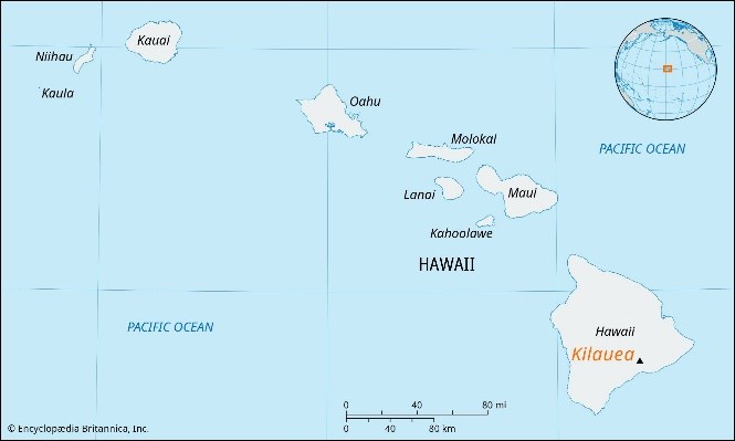
- 24 Dec 2024
In News:
Kilauea volcano erupts on Hawaii's Big Island.
Location:
- Kilauea is located on the southeastern shore of Hawaii’s Big Island, within Hawaii Volcanoes National Park.
Type of Volcano:
- Active Shield Volcano – Kilauea is a shield volcano, meaning it has broad, gentle slopes due to the eruption of fluid lava, which flows easily across large areas. Its eruptions tend to be less explosive than those of other types of volcanoes, creating a relatively safe environment for research and tourism compared to more volatile volcanoes.
Key Features:
- Summit Caldera: Kilauea has a large caldera at its summit, Halema'uma'u, which is a major volcanic feature. The caldera formed from the partial collapse of the volcano after the eruption of large amounts of magma. The caldera spans around 3 miles in length and 2 miles in width, covering an area of over 4 square miles.
- Rift Zones: Kilauea has two active rift zones stretching to the east and southwest, which are areas where lava can erupt and spread across the island. These rift zones are responsible for much of the volcanic activity.
- Lava Flows: Over the last 1,000 years, Kilauea has covered 90% of its surface with lava flows, making it one of the most active volcanoes in the world. It is known for producing highly fluid lava, which allows the lava to travel long distances from the eruption site.
- Historical Activity: Kilauea has had near-continuous eruptions in modern history, particularly between 1983 and 2018, with 34 eruptions since 1952. The volcano has remained active with frequent eruptions, and its lava lake was visible at the summit until 1924.
- Mythological Significance: The volcano is considered the home of Pele, the Hawaiian goddess of fire, lightning, and volcanoes. The Halema'uma'u crater is especially sacred, as it is believed to be the goddess's dwelling place.
Why is Kilauea Significant?
- Active and Young: Kilauea is one of the youngest volcanic products of the Hawaiian hotspot, a series of volcanic islands formed by the movement of the Pacific plate over a stationary plume of hot material beneath the Earth’s crust.
- Continuous Eruptions: It has been erupting regularly, with the exception of a quiet period between 1924 and 1952. Its eruptions are a significant natural phenomenon that scientists and visitors closely monitor.
- Proximity to Mauna Loa: Kilauea is located near Mauna Loa, another active shield volcano. Together, these two volcanoes form a large volcanic region, and their slopes merge seamlessly, making this area home to two of the world's most active volcanoes.
Shield Volcanoes and Kilauea
- Shield Volcanoes: A shield volcano is characterized by its broad, gentle slopes. These slopes are formed by repeated eruptions of fluid basalt lava, which spreads easily over large areas. Unlike composite volcanoes, which have steep, conical shapes, shield volcanoes like Kilauea have a much wider, dome-like appearance.
- Low Explosivity: Eruptions from shield volcanoes are generally low in explosivity, and lava flows are typically slow-moving. However, explosive events can occur if water interacts with lava, but this is relatively rare in Kilauea's eruptions.
Kilauea's Current Activity
In December 2024, Kilauea began erupting again, continuing its pattern as one of the most active volcanoes in the world. This eruption has once again drawn attention to the ongoing volcanic activity on the Big Island of Hawaii, as the volcano regularly contributes to the reshaping of the island and its landscape.
Other Volcanoes in India:
While Kilauea is known for its active status, India also has volcanic features, although most are dormant or extinct:
- Barren Island (Andaman Islands) – India’s only active volcano.
- Narcondam (Andaman Islands) – A dormant volcano.
- Baratang (Andaman Islands) – Known for mud volcanoes.
- Deccan Traps (Maharashtra) – A vast volcanic plateau formed by ancient eruptions.
- Dhinodhar Hills (Gujarat) – Extinct volcano.
- Dhosi Hill (Haryana) – An ancient volcanic site with historical significance.
Dark Comets

- 20 Dec 2024
In News:
Dark comets are a newly identified class of celestial objects that challenge our traditional understanding of comets and asteroids. Unlike regular comets, these objects exhibit characteristics that blur the lines between comets and asteroids, leading astronomers to closely study their nature, origin, and significance.
Discovery and Background
The first hint of dark comets appeared in 2016, when asteroid 2003 RM exhibited strange orbital deviations that suggested it might be a comet in disguise. NASA further fueled this interest in 2017 when it discovered ‘Oumuamua, an interstellar object that entered our Solar System. Though initially classified as an asteroid, its erratic motion and lack of a visible tail led scientists to consider it a dark comet. Since then, several more objects with similar characteristics have been discovered, and astronomers now identify these objects as a new class—dark comets.
Characteristics of Dark Comets
- Appearance: Dark comets do not exhibit the brilliant, glowing tails typically associated with comets. Instead, they resemble asteroids, appearing as faint points of light in space. Unlike bright comets, they do not have a visible coma (a cloud of gas and dust) or a tail, making them much harder to detect.
- Size: Dark comets are typically small, ranging from a few meters to a few hundred meters in diameter. Due to their small size, there is less surface area for material to escape, preventing the formation of the iconic tails seen in traditional comets.
- Orbital Path: These objects follow elongated, elliptical orbits. While some of them travel close to the Sun, they can also venture to the outer reaches of the Solar System, far beyond Pluto, and even into the Oort Cloud—the distant region where long-period comets are believed to originate.
- Spin and Gas Dispersion: Dark comets often rotate rapidly, dispersing gas and dust in all directions. This rapid spin contributes to their invisibility, as the gas and dust are scattered evenly, making it more difficult for astronomers to detect their presence.
- Composition: The composition of dark comets may also play a role in their lack of visibility. Over time, the materials that form the bright tails of comets may be depleted, especially for older objects. As a result, dark comets may not release enough gas to produce a visible coma or tail.
Types of Dark Comets
There are two main categories of dark comets:
- Inner Dark Comets: These are smaller objects that reside closer to the Sun and typically travel in nearly circular orbits. They are often just a few meters in size, with less surface area for gas and dust to escape.
- Outer Dark Comets: These larger objects, measuring over 100 meters in diameter, travel in highly eccentric orbits, similar to Jupiter-family comets. These dark comets follow elliptical paths that bring them close to the Sun and then send them back toward the outer reaches of the Solar System.
Importance of Studying Dark Comets
Dark comets may hold critical clues about the early Solar System and the formation of Earth. Studying these objects can provide insights into the origins of water on Earth, as well as the ingredients necessary for life. Their unique composition and orbits also offer potential for understanding the processes that led to the formation of planets.
Recent Discoveries and Advancements
Astronomers recently discovered 10 new dark comets with the help of the Dark Energy Camera (DECam) on a large telescope in Chile. The DECam, designed to study distant galaxies and stars, has enabled researchers to detect these faint objects by analyzing images of the night sky. Further progress is expected with the upcoming Vera C. Rubin Observatory, which will feature the largest digital camera ever built. This new instrument will allow astronomers to capture more detailed images of the night sky and detect fainter objects, potentially doubling or even tripling the number of known dark comets in the next decade.
Key Facts:
- Dark comets lack the characteristic glowing tails of typical comets, instead resembling asteroids.
- They exhibit erratic motions and follow elliptical orbits, often extending beyond Pluto and into the Oort Cloud.
- They are typically small (a few meters to hundreds of meters wide) and spin rapidly.
- The first dark comet was identified in 2016, with more discoveries made in the years since.
- The Dark Energy Camera (DECam) in Chile has been instrumental in detecting these elusive objects, with a new Vera C. Rubin Observatory expected to further enhance detection in the future.
- Studies suggest that between 0.5% and 60% of Near-Earth Objects (NEOs) could be dark comets, many originating from the asteroid belt between Mars and Jupiter.
Cyclone Chido
- 18 Dec 2024
In News:
Cyclone Chido makes landfall in Mozambique after leaving trail of destruction in French-administered Mayotte.
About Cyclone Chido:
- Location and Impact:
- Cyclone Chido struck Mayotte, a French overseas territory in the Indian Ocean, in December 2024.
- It is the strongest storm to hit Mayotte in at least 90 years.
- Cyclone Characteristics:
- Wind speeds exceeded 200 km/h (124 mph), with gusts surpassing 225 km/h (140 mph).
- The cyclone caused significant devastation to the region, prompting expressions of condolences from global leaders.
- Cyclone Classification:
- According to the Indian Meteorological Department (IMD), cyclones are classified based on wind speed:
- Depression: 31–49 km/h
- Deep Depression: 50–61 km/h
- Cyclonic Storm: 62–88 km/h
- Severe Cyclonic Storm: 89–117 km/h
- Very Severe Cyclonic Storm: 118–166 km/h
- Extremely Severe Cyclonic Storm: 167–221 km/h
- Super Cyclonic Storm: Above 222 km/h
- Cyclone Chido was classified as a Super Cyclonic Storm, based on its wind speeds exceeding 222 km/h.
- According to the Indian Meteorological Department (IMD), cyclones are classified based on wind speed:
About Mayotte:
- Geography:
- Mayotte is an archipelago in the Mozambique Channel, between Madagascar and the coast of Mozambique.
- It consists of two main islands: Grande Terre (the larger main island) and Petite Terre (the smaller island of Pamandzi).
- Political and Economic Context:
- Mayotte is an overseas department of France, and it is the poorest territory in both France and the European Union.
- France colonized Mayotte in 1843 and annexed the entire Comoros archipelago in 1904.
- A 1974 referendum showed that 95% of Comoros voters favored independence, but 63% of Mayotte's population voted to remain part of France. Subsequently, Grande Comore, Anjouan, and Moheli declared independence in 1975.
- Mayotte remains administratively under French governance.
- Biodiversity:
- Mayotte is renowned for its rich biodiversity, particularly for having one of the world’s largest enclosed lagoons.
Cyclones
- What is a Cyclone?
- A cyclone is a large-scale, rotating system of air that forms around a low-pressure area, bringing violent storms and extreme weather conditions.
- In the Northern Hemisphere, cyclones rotate anticlockwise, while in the Southern Hemisphere, they rotate clockwise due to the Coriolis effect.
- Tropical Cyclone Characteristics:
- Calm Centre (Eye): The cyclone’s center, or "eye," experiences relatively calm weather with low air pressure.
- High Wind Speed: Cyclones generally have average wind speeds around 120 km/h.
- Closed Isobars: Isobars (lines of equal atmospheric pressure) are tightly packed, leading to high wind velocities.
- Formation Over Oceans: Cyclones typically form over warm ocean waters.
- East-to-West Movement: Influenced by trade winds, cyclones usually move from east to west.
- Seasonal Nature: Cyclones occur during specific seasons based on regional climatic conditions.
How La Niña Affects India's Climate?
- 28 Dec 2024
In News:
La Niña, a phase of the El Niño Southern Oscillation (ENSO), occurs when the Pacific Ocean region between Indonesia and South America is cooler than usual. This phenomenon influences global weather patterns, including those in India. Here’s how La Niña specifically affects India’s climate:
Monsoon Rainfall:
- La Niña typically results in normal to above-normal rainfall during the monsoon season in India. This is due to the cooling of sea surface temperatures in the central Pacific, which affects atmospheric circulation and strengthens the monsoon winds.
- In contrast, El Niño usually brings below-average rainfall and droughts to India, leading to agricultural stress.
- Recent La Niña years (2020-2022) saw above-normal monsoon rains, which benefited agricultural productivity, while the El Niño year of 2023 resulted in below-normal rains, impacting water availability and agriculture.
Winter Temperatures:
- During La Niña, winter temperatures in India are generally colder in the north, with cooler nights but relatively warmer days compared to El Niño winters. The planetary boundary layer height (PBLH) tends to be lower, trapping pollutants close to the surface. However, higher wind speeds during La Niña help to disperse air pollution, improving air quality.
- South India may experience colder-than-usual winters during La Niña, but current meteorological data suggests the ongoing winter in India is not strongly influenced by La Niña, as its expected onset has been delayed.
Impact on Summer Heat:
- La Niña generally provides relief from extreme summer heat, as it reduces the frequency and intensity of heatwaves. In contrast, El Niño summers are typically hotter and bring record-breaking heat waves.
- For example, April 2023 saw intense heatwaves across India, attributed to the El Niño phase, but if a La Niña forms and persists into the summer of 2025, it could help moderate the extreme heat.
The "Triple Dip" La Niña Phenomenon:
- A Triple Dip La Niña refers to a rare occurrence where three consecutive La Niña events happen, as was the case from 2020 to 2022. This is significant because these prolonged events can lead to stronger climatic impacts. In contrast, the current El Niño (2023) follows this period, potentially contributing to an irregular transition between La Niña and El Niño phases, which may intensify extreme weather patterns.
Global Climate Changes and La Niña:
- Climate change is believed to be increasing the frequency and intensity of both La Niña and El Niño events. Rising sea and land temperatures are disrupting the balance of the Pacific Ocean and could exacerbate extreme La Niña events, which might lead to harsher winters in India and other regions.
Forecast for 2024-2025:
- As of December 2024, the India Meteorological Department (IMD) and global meteorological bodies predict a weak La Niña event to emerge by late 2024 or early 2025. This could lead to colder winters and above-normal rainfall in the 2025 monsoon season, offering some relief from the heatwaves and dry conditions of the previous years.
Conclusion:
If a La Niña forms by the end of 2024, it is likely to bring cooler winters, a relief from extreme summer heat, and above-normal monsoon rainfall in 2025. Given the delayed onset and weakening of the current La Niña, the overall impact on India’s climate in the immediate future might be milder compared to previous La Niña years, but it still holds potential for more favorable conditions for agriculture and air quality.
Cyclone Fengal
- 27 Nov 2024
In News:
- A deep depression in the Southwest Bay of Bengal, 800 km south of Chennai and 500 km from Nagapattinam, is expected to become Cyclone Fengal within the next 24 hours.
- It is anticipated to move north-northwest towards Tamil Nadu and Puducherry.
Key Highlights:
Cyclone Fengal Naming:
- If the depression intensifies into a cyclone, it will be named Fengal, as suggested by Saudi Arabia.
- Fengal will follow Cyclone Dana, which made landfall in Odisha in October 2024.
Cyclone Naming Process:
- Panel Members: Cyclones in the North Indian Ocean are named by a panel of 13 countries under the World Meteorological Organization (WMO) and United Nations Economic and Social Commission for Asia and the Pacific (UNESCAP).
- Member countries include Bangladesh, India, Iran, Maldives, Myanmar, Oman, Pakistan, Qatar, Saudi Arabia, Sri Lanka, Thailand, the UAE, and Yemen.
- Process: Each member submits a list of 13 names, creating a rotational naming system. Names are assigned sequentially as cyclones form. Once used, a name is retired and not reused.
Cyclone Fengal’s Potential Impact:
- Fengal is expected to bring strong winds, heavy rainfall, and possible coastal flooding.
- The system’s trajectory is being closely monitored, and preparedness measures are being implemented.
Terminology of Tropical Cyclones:
Terminology Region Impact Areas
Typhoons China Sea, Pacific Ocean Japan, China, Philippines
Hurricanes Caribbean Sea, Atlantic Ocean United States, Mexico,
Caribbean nations
Tornadoes Guinea Lands (West Africa), Southern USA Southern USA, West Africa
Willy-willies Northwestern Australia Australia (especially
Northwestern region)
Chinar Boat Race 2024
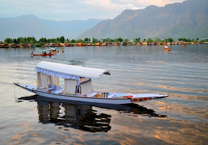
- 24 Nov 2024
In News:
- The Chinar Boat Race 2024 was successfully organized in Dal Lake, Srinagar, Jammu and Kashmir.
Key Highlights:
- Organizers:The event was hosted by the Indian Army in collaboration with White Globe NGO and the Lake Conservation and Management Authority (LCMA).
- Purpose:The race aimed to celebrate Kashmir’s culture and traditions while promoting conservation of Dal Lake.The event emphasized the ecological importance of Dal Lake and the need for its protection.
- Cultural Impact:The race attracted a large crowd of both locals and tourists, highlighting the vibrant culture of Kashmir.The event fostered a sense of community and unity, with people cheering for the participants.
- Military Engagement:The Army organizes sports and cultural events in the region to strengthen Army-public relationships, engage local youth, and promote an honourable profession in the military.
Dal Lake Overview:
- Location: Situated in Srinagar, Jammu and Kashmir, surrounded by the PirPanjal mountains.
- Area: 18 sq. km (lake); part of a 21.1 sq. km wetland.
- Islands: Includes 3 islands, two marked by Chinar trees: Roph Lank (Silver Island) and Sone Lank (Gold Island).
- Significance: Known as the “Jewel in the crown of Kashmir” or “Srinagar’s Jewel”.
- Floating Market: Famous for its floating market where vendors use wooden boats (Shikaras) to sell goods.
- Temperature: Can drop to −11°C in winter, sometimes freezing the lake.
Hong Kong Discovers Dinosaur Fossils
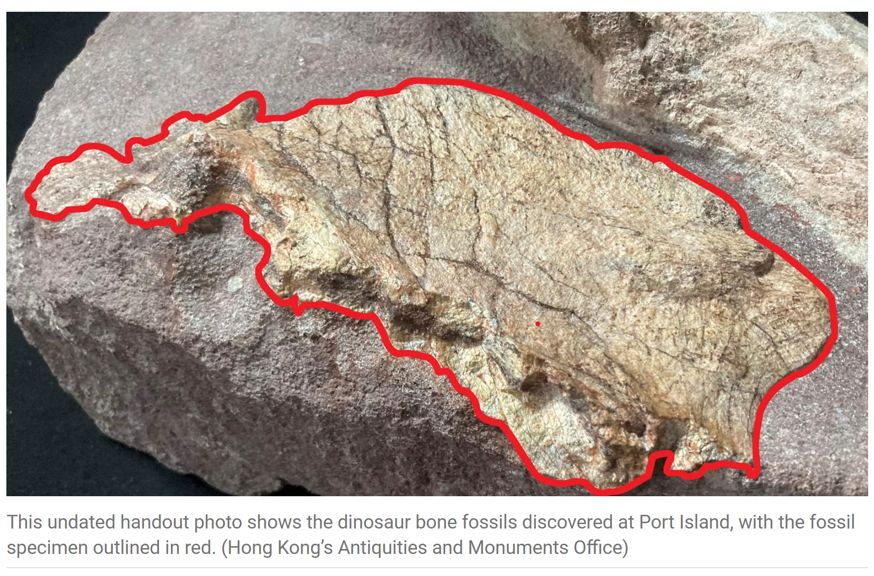
- 28 Oct 2024
In News:
Hong Kong discovers dinosaur fossils for the first time
Key Details:
-
- Significance: This marks the first-ever discovery of dinosaur fossils in Hong Kong.
- Time Period:The fossils date back to the Cretaceous Period, approximately 145 million to 66 million years ago.
- Fossil Details:The fossils belong to a large dinosaur, but further studies are required to determine the exact species.Initial analysis suggests the dinosaur may have been buried by sand and gravel after death, later being washed to the surface by a flood before being buried again.
- Site and Protection:Port Island, part of a geopark, is closed to the public to facilitate ongoing fossil investigations and excavation work.
- Geological and Archaeological Importance:The discovery underscores the significance of Hong Kong's geoparks and its role in preserving and showcasing natural history.This finding contributes to global understanding of prehistoric life, especially in the Cretaceous period.
India's Mission Mausam and the Cloud Chamber
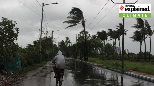
- 23 Oct 2024
In News:
Mission Mausamaims to not just improve weather forecasting in the country but also ‘manage’ certain weather events, and on demand, enhance or suppress rainfall, hail, fog and, later, lightning strikes.
- Focus Areas:
- Enhancing or suppressing rainfall, hail, fog, and later, lightning strikes on demand.
- Strengthening cloud physics research to better understand and modify weather conditions.
- Establishment of Cloud Chamber:
- Location: The cloud chamber is being built at the Indian Institute of Tropical Meteorology (IITM) in Pune.
- Purpose: To study cloud physics in detail and develop methods for weather modification.
- Key Feature: It will be a convective cloud chamber, capable of simulating conditions specific to Indian monsoon clouds.
What is a Cloud Chamber?
- A scientific apparatus that mimics the conditions required for cloud formation.
- Function: Water vapour, aerosols, and other particles are injected into the chamber, and under controlled temperature and humidity conditions, clouds can be formed.
- Global Context: While many countries have cloud chambers, India is building one with convection properties, which are essential for studying monsoon clouds. Only a few such chambers exist globally.
Why India Needs a Convective Cloud Chamber?
- Cloud Physics: The chamber will allow scientists to study various phenomena such as:
- Cloud behaviour under normal and extreme conditions.
- Formation of rain droplets and ice particles.
- Influence of moisture from cyclones or low-pressure systems.
- Interactions between different cloud layers.
- Objective: To gain insights into cloud formation specific to the Indian monsoon and develop strategies for weather modification.
Applications for Weather Modification:
- The cloud chamber will help scientists simulate and understand how to influence weather events like rain and fog, particularly in monsoon systems.
- It will allow testing of new ideas and theories under controlled conditions, adjusting temperature, humidity, and convection parameters to suit Indian weather conditions.
India’s Experience with Cloud Seeding:
- Cloud Seeding: A technique tested in India to enhance rainfall by introducing particles (seeds) into clouds.
- CAIPEEX Program: India conducted the Cloud Aerosol Interaction and Precipitation Enhancement Experiment (CAIPEEX) over a decade to study cloud seeding's effectiveness.
- Findings: Cloud seeding increased rainfall by up to 46% in some regions, showing its potential under specific conditions.
- Limitations: Cloud seeding is not a one-size-fits-all solution and is effective only under certain conditions.
Significance for India’s Weather Forecasting:
- Improved Weather Modification: The cloud chamber and insights from it could lead to better management of weather events, especially in regions affected by monsoon rains, cyclones, and droughts.
- Tailored Strategies: India will be able to implement targeted weather interventions, especially in agricultural regions, to reduce the negative impacts of extreme weather.
???????Global and Regional Relevance:
- Cloud Chamber: The Pune facility will be one of the few globally with the specific focus on convective properties needed to study Indian monsoon systems.
- Role in Climate Science: India’s investment in cloud physics research positions it at the forefront of developing technologies to manage climate variability and extreme weather events.
Ladakh's Aurorae
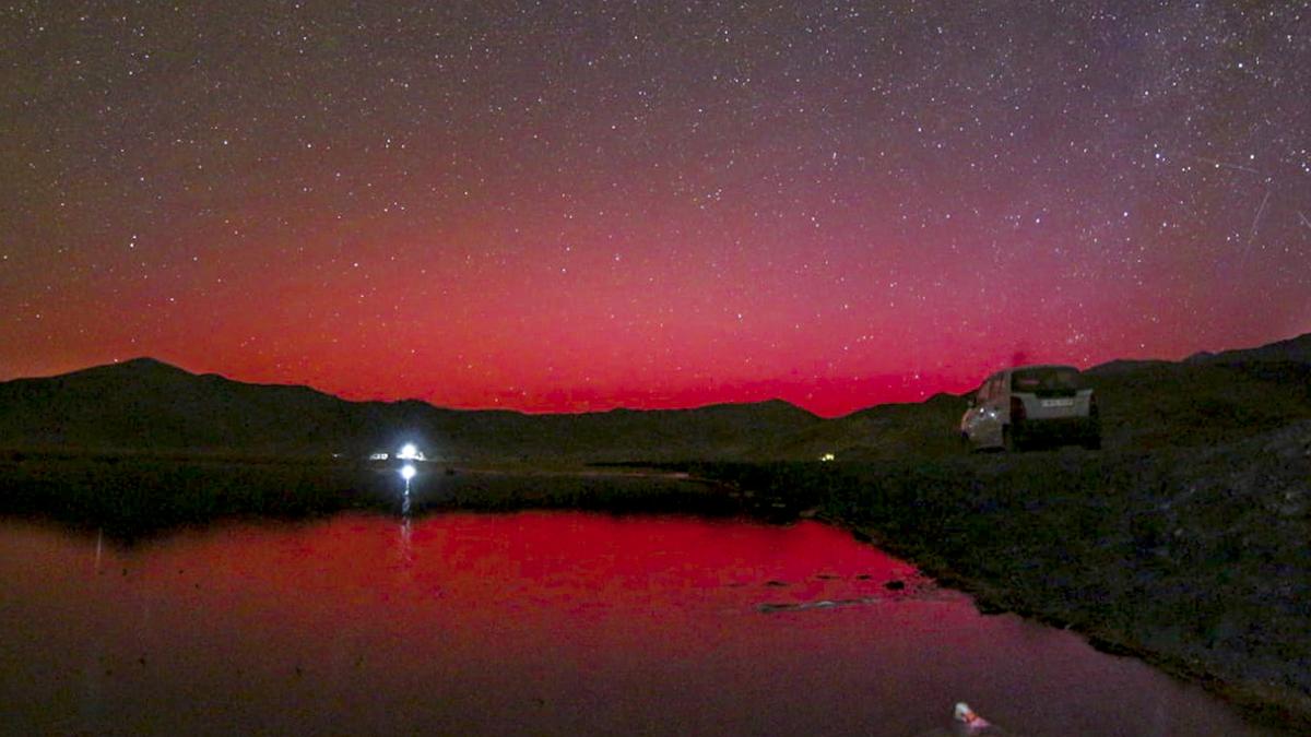
- 14 Oct 2024
In News:
In October 2024, Ladakh witnessed spectacular auroras, typically seen in higher latitudes, indicating increased solar activity. This phenomenon was reported following intense solar storms, with red and green lights observed in the night sky. The auroras were captured by all-sky cameras operated by the Indian Institute of Astrophysics (IIA) in Hanle and Merak.
What Are Auroras?
Auroras are vibrant displays of light caused by interactions between charged particles from the Sun and Earth's magnetosphere. When solar winds—streams of charged particles—collide with atoms in the upper atmosphere, they create visible light, similar to how neon lights function.
Causes of Recent Auroras
The recent auroras in Ladakh were linked to several strong solar storms, particularly coronal mass ejections (CMEs), which are significant bursts of solar wind and magnetic fields rising above the solar corona. The storms, emanating from active solar regions, traveled towards Earth at remarkable speeds, disrupting the normal space weather and allowing auroras to be visible at lower latitudes, including Mexico and Germany.
Implications of Solar Activity
Astrophysicists at the Center of Excellence in Space Sciences India (CESSI) noted that these auroras validate ongoing efforts in space weather monitoring. The increased solar activity is part of the solar cycle, which peaks approximately every 11 years. Current predictions indicate that Solar Cycle 25 may reach its peak in 2024.
Monitoring Space Weather
Organizations like the National Oceanic and Atmospheric Administration (NOAA) closely monitor space weather to provide timely warnings about solar events that could disrupt satellite communications and other services. The CESSI team successfully predicted the occurrence of solar storms, enhancing confidence in their ability to forecast space weather and its potential impacts.
Potential Hazards
While auroras are visually striking, intense solar storms can have detrimental effects, including:
- Satellite Disruption: Increased drag and radiation can damage satellites in low Earth orbit, affecting navigation, communications, and military operations.
- Communication Blackouts: Severe storms can interfere with radio and satellite communications, impacting daily life and services.
Little Prespa Lake's Decline
- 03 Oct 2024
In News:
Little Prespa Lake on Albanian-Greek border slowly dying.
Overview of Little Prespa Lake's Decline
- Location and Geography:
- Little Prespa Lake is situated on the Albanian-Greek border, primarily in Greece with a southern tip extending into Albania.
- It covers approximately 450 hectares in Albania, now largely transformed into swamps or dry land.
- Ecological Changes:
- Once a crystal-clear lake, it has degraded into a marshy area, with about 430 hectares in Albania suffering from significant drying.
- Local wildlife has shifted; cows now roam where fish once thrived.
- Historical Context:
- The lake's decline began in the 1970s when Albanian authorities diverted the Devoll River to irrigate surrounding agricultural lands, severely limiting water inflow.
- Climate Change Impact:
- Rising temperatures, mild winters, and decreased precipitation have intensified the lake’s ecological crisis.
- Local experts warn that continued dry winters and hot summers could lead to irreversible damage.
La Nina and North India’s pollution
- 01 Oct 2024
In News:
Recent research by scientists at the National Institute of Advanced Science (NIAS) has underlined the links between climate change, La Niña and air quality.
Key Points on Air Quality Outlook for Delhi and North India
- Delayed La Niña & Monsoon Retreat:
- Erosion of optimism for improved air quality this winter in Delhi.
- Significant pollution challenges anticipated in early winter months.
- Possible relief in December and January, contingent on La Niña strengthening.
- Impact of Stubble Burning:
- If stubble burning occurs at half the intensity of previous years, November air quality may deteriorate.
- Research Insights:
- Study by National Institute of Advanced Science (NIAS) links climate change, La Niña, and air quality.
- Notable air quality improvement in winter 2022-23 was linked to La Niña conditions.
- Late onset of La Niña contributes to air quality uncertainty.
- Changing Pollution Dynamics:
- Shift from local emission-centric views to broader climatological factors is necessary.
- Air quality in Delhi worsens during winter due to high humidity, calm winds, and poor pollutant dispersion.
- La Niña Delays:
- Delayed La Niña onset means weak winds and stagnant conditions, worsening pollution.
- Expected development between September and November 2024.
- Effects of Stubble Burning:
- North-north-westerly winds could carry pollution from stubble burning in Punjab and Haryana into Delhi.
- Potential Outcomes of Late La Niña Onset:
- If La Niña develops in December or January, may improve air quality slightly.
- However, a longer, severe winter could exacerbate pollution issues due to lower inversion layers.
- NIAS-SAFAR Model Predictions:
- Early La Niña could have worsened air quality in the peninsular region.
- Early onset might have improved northern air quality.
- Link to Climate Change:
- Evidence suggests extreme air pollution correlates with climate change.
- Emphasizes the need for rigorous mitigation efforts and broader airshed management.
- Call for Rethinking Air Quality Strategies:
- Focus on integrating larger climatic factors into air quality policies.
- Prioritize health-centric measures through collaborative efforts with scientific bodies.
What is La Niña?
- La Niña (or ‘The Little Girl’ in Spanish) is a phase of what climatologists refer to as the El Niño Southern Oscillation (ENSO), a phenomenon that is a key driver of global natural climate variability.
- ENSO is characterised by changes in sea temperatures along the tropical Pacific Ocean due to atmospheric fluctuations overhead. These changes alter and interfere with the global atmospheric circulation, and influence weather worldwide.
- Occurring in irregular cycles of anywhere between two to seven years, ENSO has three phases — warm (El Niño or ‘The Little Boy’ in Spanish), cool (La Niña), and neutral.
- During the neutral phase, the eastern Pacific (off the northwestern coast of South America) is cooler than the western Pacific (around Philippines and Indonesia). This is because prevailing trade winds — caused by Earth’s rotation, between 30 degrees north and south of the equator — move east to west, sweeping warmer surface water along with them. The relatively cool waters from below rise to the surface to replace the displaced water.
- These wind systems weaken in the El Niño phase, leading to lesser displacement of warmer waters off the American coasts. Consequently, the eastern Pacific becomes warmer than usual. The opposite happens in the La Niña phase i.e. trade winds become stronger than usual and push larger quantities of water to the western Pacific.
Uncommon Cyclones in the Arabian Sea
- 09 Sep 2024
Cyclones are intense weather systems with low atmospheric pressure and rotating winds, forming over warm tropical waters. These storms cause severe weather, including heavy rainfall, strong winds, and storm surges. Cyclones are categorized based on wind speeds, from tropical depressions to severe cyclonic storms. Warm ocean surfaces and high humidity fuel these storms, with atmospheric conditions like wind shear and moisture influencing their strength and formation.
The North Indian Ocean plays a key role in global weather systems, particularly the summer monsoon. Warm waters from the Arabian Sea and Bay of Bengal are crucial for moisture generation during monsoon seasons. However, despite the warm ocean surfaces that typically promote cyclones, this region has fewer cyclones compared to other tropical oceans. A mix of factors—both promoting and suppressing cyclone formation—makes the North Indian Ocean a unique and less cyclone-prone area.
The Indian Ocean stands out due to its monsoonal circulation, marked by seasonal wind reversals north of the equator. It also has "oceanic tunnels" connecting it to the Pacific and Southern Oceans, which influence its weather. The Pacific tunnel introduces warm water into the upper layers, while the Southern Ocean brings cooler waters into deeper levels. These oceanographic features contribute to distinct weather patterns, including influencing the formation and behavior of cyclones.
As the pre-monsoon season begins and the Sun moves into the northern hemisphere, the Arabian Sea rapidly warms. The Bay of Bengal, typically warmer, heats further, driving atmospheric convection and rainfall. These warming patterns make the Bay of Bengal more prone to cyclones, while the Arabian Sea, with its cooler waters and stronger wind shear, experiences less cyclone activity. These conditions contribute to significant differences in cyclone formation between the two seas.
Impact of Climate Change on Cyclones in the Indian Ocean
Climate change is amplifying the Indian Ocean’s warming, bringing in more heat from the Pacific Ocean while the Southern Ocean pushes warmer waters into deeper layers. These changes, combined with shifts in winds and atmospheric humidity, are causing the Indian Ocean to warm at a rapid pace. This warming is affecting cyclone formation, increasing the frequency and intensity of storms. The Indian Ocean acts as a "clearinghouse" for ocean warming, impacting global weather patterns and intensifying cyclone activity.
Monsoon and Cyclone Seasons in the North Indian Ocean
- The monsoon heavily influences cyclone activity in the region. During the monsoon, strong winds cool the Arabian Sea, reducing the likelihood of cyclone formation. In contrast, the Bay of Bengal sees more low-pressure systems, although many do not become cyclones due to wind shear that weakens their energy.
- The North Indian Ocean experiences two distinct cyclone seasons—pre-monsoon and post-monsoon—unlike other regions that typically have just one. Cooler temperatures and stronger wind shear keep cyclone numbers low in the Arabian Sea, compared to the Bay of Bengal.
- Cyclone Asna, formed in August 2023, was a rare cyclone for this time of year. It developed from a land-based depression that moved over the Arabian Sea, marking the first August cyclone in the region since 1981. This rare occurrence highlights how rapidly warming oceans, influenced by climate change and El Niño, can drive unexpected cyclone formations.
Typhoon Yagi
- 10 Sep 2024
In News:
A devastating series of events unfolded in Vietnam, as a bridge collapsed and a bus was swept away by severe flooding, raising the death toll to at least 65. The fatalities are attributed to Typhoon Yagi and the subsequent heavy rains, which have wreaked havoc across the Southeast Asian country.
In Depth:
- The typhoon made landfall in Vietnam’s northern coastal provinces of Quang Ninh and Haiphong with wind speeds of up to 149 kilometers per hour (92 miles per hour) on Saturday afternoon.
- It raged for roughly 15 hours before gradually weakening into a tropical depression early Sunday morning.
- Vietnam’s meteorological department predicted heavy rain in northern and central provinces and warned of floods in low-lying areas, flash floods in streams and landslides on steep slopes.
What is a cyclone?
- The term 'Cyclone' is derived from the Greek word 'Cyclos' which means 'Coiling of the Snake'.
- Cyclones are created by atmospheric disturbances around a low-pressure area and are usually accompanied by violent storms and severe weather conditions. Basically, a tropical cyclone is a deep low-pressure area.
Tropical Cyclone Remal
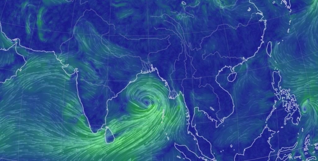
- 24 May 2024
Why is it in the News?
The first cyclone in the Bay of Bengal this pre-monsoon season, Cyclone Remal, is expected to make landfall between Sagar Island in West Bengal and Bangladesh's Khepupara on Sunday midnight.
About Cyclone Remal:
- The IMD has forecasted that a depression in the Bay of Bengal is likely to concentrate into a severe cyclonic storm and make landfall between Sagar Island in West Bengal and Khepupara in Bangladesh around May 26 midnight.
Name of the cyclone:
- If the cyclone is formed, it will be named 'Remal', which means 'sand' in Arabic.
- The cyclone has been named ‘Remal’, according to a system of naming cyclones in the Indian Ocean region.
- A standard naming convention is followed for tropical cyclones forming in the North Indian Ocean, including the Arabian Sea and the Bay of Bengal.
- As the IMD is a part of the Regional Specialised Meteorological Centres (RSMCs), it gives names to the tropical cyclones after consulting 12 other countries in the region.
- The name 'Remal' has been suggested by Oman which means 'sand' in Arabic.
What is a Tropical Cyclone?
- A tropical cyclone is a rapidly rotating storm system characterized by a low-pressure centre, strong winds, and a spiral arrangement of thunderstorms that produce heavy rain.
- These cyclones develop over warm tropical or subtropical waters and can cause significant damage due to high winds, heavy rainfall, and storm surges.
How a Tropical Cyclone is Formed?
- Tropical cyclones form over warm ocean waters near the equator.
- The process begins when warm, moist air rises from the ocean surface, creating an area of low pressure.
- This causes surrounding air with higher pressure to move toward the low-pressure area, warming up and rising as well.
- As this air rises and cools, the moisture condenses to form clouds.
- The system of clouds and wind starts to spin and grow, fueled by the ocean's heat.
- When the wind speeds increase sufficiently, an eye forms in the centre of the cyclone.
Characteristics of a Tropical Cyclone:
- Calm Center: The eye of the cyclone is calm and clear, with very low air pressure.
- High Wind Speeds: The average wind speed of a tropical cyclone is around 120 km/h.
- Closed Isobars: These are lines on a weather map that connect areas of equal atmospheric pressure, leading to greater wind velocity.
- Oceanic Origin: Tropical cyclones develop over oceans and seas.
- Movement: They typically move from east to west under the influence of trade winds.
- Seasonal: Tropical cyclones are seasonal phenomena.
How are Cyclones Classified?
- The Indian Meteorological Department (IMD) classifies cyclones based on wind speeds:
- Depression: Wind speeds between 31–49 km/h
- Deep Depression: Wind speeds between 50-61 km/h
- Cyclonic Storm: Wind speeds between 62–88 km/h
- Severe Cyclonic Storm: Wind speeds between 89-117 km/h
- Very Severe Cyclonic Storm: Wind speeds between 118-166 km/h
- Extremely Severe Cyclonic Storm: Wind speeds between 166-221 km/h
- Super Cyclonic Storm: Wind speeds above 222 km/h
El Niño and La Nina
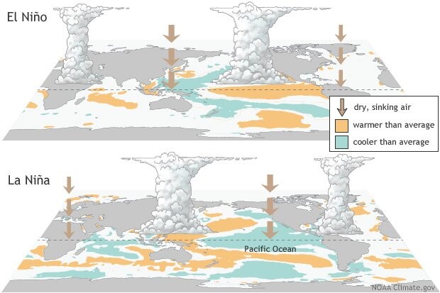
- 23 May 2024
Why is it in the News?
Last month, the India Meteorological Department (IMD) forecasted above-normal rain in the upcoming monsoon season in India, with “favourable” La Nina conditions expected to set in by August-September.
What are El Niño and La Nina?
- El Niño (meaning “little boy” in Spanish) and La Nina (meaning “little girl” in Spanish) are climate phenomena that are a result of ocean-atmosphere interactions, which impact the temperature of waters in the central and eastern tropical Pacific Ocean which affects global weather.
- The Earth’s east-west rotation causes all winds blowing between 30 degrees to the north and south of the equator to slant in their trajectory.
- As a result, winds in the region flow towards a southwesterly direction in the northern hemisphere and a northwesterly direction in the southern hemisphere which is known as the Coriolis Effect.
- Due to this, winds in this belt (called trade winds) blow westwards on either side of the equator.
- Under normal ocean conditions, these trade winds travel westwards along the equator from South America towards Asia.
- Wind movement over the ocean results in a phenomenon called upwelling, where cold water beneath the ocean surface rises and displaces the warm surface waters.
- At times, the weak trade winds get pushed back towards South America and there is no upwelling.
- Thus, warmer-than-usual sea surface temperatures are recorded along the equatorial Pacific Ocean, and this is known as the emergence of El Niño conditions.
- Conversely, during La Nina, strong trade winds push warm water towards Asia.
- Greater upwelling gives rise to cold and nutrient-rich water towards South America.
- Thus, climatologically, El Niño and La Nina are opposite phases of what is collectively called the El Niño Southern Oscillation (ENSO) cycle.
- It also includes a third neutral phase.
- El Niño events are far more frequent than La Nina ones.
- Once every two to seven years, neutral ENSO conditions get interrupted by either El Niño or La Nina.
- Recently, La Nina conditions prevailed between 2020 and 2023.
How could the incoming La Nina impact global weather?
- La Niña, driven by the cooling of ocean waters due to the ENSO (El Niño-Southern Oscillation) cycle, can significantly influence global weather patterns.
- The air circulation loop in the region, affected by these temperature changes, impacts precipitation levels in neighbouring areas and can alter the Indian monsoon.
- Currently, the El Niño event that began in June last year has significantly weakened.
- Neutral ENSO conditions are expected to be established by June.
- Following this, La Niña conditions are anticipated to emerge, with its effects likely becoming apparent from August.
La Nina’s Impact on India:
- With above normal rain forecast, the seasonal rainfall is expected to be 106 per cent of the Long Period Average (LPA), which is 880mm (1971-2020 average).
- Except in east and northeast India, all remaining regions are expected to receive normal or above-seasonal rainfall.
- Heavy rains could result in some regions witnessing riverine and urban flooding, mudslides, landslides and cloudbursts.
- East and northeast India region, during La Nina years, receive below average seasonal rainfall.
- Therefore, there may be a shortfall in water reserves there this year.
- During La Nina years, incidents of thunderstorms generally increase.
- “The east and northern India regions could experience thunderstorms accompanied by lightning.
- With increased farming activities undertaken during the July and August rainy months, which coincides with the season’s enhanced lightning and thunderstorms, there is a high risk of fatalities in these regions.
- In addition to ENSO, there are other parameters that can impact the monsoon.
- However, in a La Nina year, a deficit monsoon over India can be easily ruled out.
La Nina’s Impact on the World:
- Similar to India, Indonesia, the Philippines, Malaysia and their neighbouring countries receive good rainfall during a La Nina year.
- This year, Indonesia has already witnessed floods.
- On the other hand, droughts are common in southern regions of North America, where winters become warmer than usual.
- Canada and the northwestern coast of the United States see heavy rainfall and flooding.
- Southern Africa receives higher than usual rainfall, whereas eastern regions of the continent suffer below-average rainfall.
- ENSO has a huge impact on hurricane activity over the Atlantic Ocean.
- During a La Nina year, the hurricane activity here increases.
- For instance, the Atlantic Ocean churned out a record 30 hurricanes during the La Nina year 2021.
Is Climate Change Affecting ENSO?
- Over India, El Niño is known to suppress the southwest monsoon rainfall and drive higher temperatures and intense heat waves, like the present summer season.
- In the past, monsoon seasons during years following an El Niño were 1982-1983 and 1987-1988, with both 1983 and 1988 recording bountiful rainfall.
- At present too, a similar situation could play out.
- The 2020-2023 period witnessed the longest La Nina event of the century.
- Thereafter, ENSO neutral conditions developed, which soon gave way to El Niño by June 2023 which has been weakening since December last year.
- Scientists say that climate change is set to impact the ENSO cycle.
- Many studies suggest that global warming tends to change the mean oceanic conditions over the Pacific Ocean and trigger more El Niño events.
- The World Meteorological Organization (WMO) has also said that climate change is likely to affect the intensity and frequency of extreme weather and climate events linked to El Niño and La Nina.
Oceanic Niño Index (ONI)
- 08 Apr 2024
Why is it in the News?
The US National Oceanic and Atmospheric Administration (NOAA) has recently forecasted an 83% likelihood that the Oceanic Niño Index (ONI) will move into a neutral range between April and June 2024.
What is the Oceanic Niño Index?
- The Oceanic Niño Index (ONI) is the National Oceanic and Atmospheric Administration's (NOAA) primary indicator for monitoring El Niño and La Niña, which are opposite phases of the climate pattern called the El Niño-Southern Oscillation, or “ENSO” for short.
- NOAA is a US governmental agency responsible for monitoring and researching the Earth's oceans, atmosphere, and climate, and providing weather forecasts and environmental data.
- The ONI is the difference between a three-month running average of the sea surface temperature averaged over an area of the ocean from 120 West to 170 West longitude along the equator and the long-term average for the same three months.
- NOAA considers El Niño conditions to be present when the Oceanic Niño Index is +0.5 or higher, indicating the east-central tropical Pacific is significantly warmer than usual.
- La Niña conditions exist when the Oceanic Niño Index is -0.5 or lower, indicating the region is cooler than usual.
What is El Niño and La Niña?
- El Niño and La Niña are two natural climate phenomena that occur in the Pacific Ocean, characterized by fluctuations in ocean surface temperatures.
- They are part of the El Niño-Southern Oscillation (ENSO) cycle, which impacts global weather patterns.
- El Niño refers to the warming of ocean surface temperatures in the eastern tropical Pacific.
- This warming causes changes in atmospheric pressure and wind patterns, which can lead to drought conditions in parts of South America and heavy rainfall in other regions, such as the southern United States.
- La Niña is the opposite phase of the ENSO cycle, characterized by cooler-than-average ocean surface temperatures in the eastern tropical Pacific.
- This results in the strengthening of normal trade winds, causing increased rainfall in some regions, such as Indonesia and northern Australia, and drier conditions in other areas, including the southwestern United States.
- El Niño refers to the warming of ocean surface temperatures in the eastern tropical Pacific.
Effects of El Niño and La Niña on India:
- Both El Niño and La Niña have significant impacts on India's climate, particularly during the monsoon season.
- El Niño events often lead to weaker monsoon winds and reduced rainfall in India, causing droughts and impacting agricultural production.
- On the other hand, La Niña events typically result in stronger monsoon winds and higher rainfall, leading to better agricultural yields.
- However, excessive rainfall can also cause floods and landslides in some regions.
- Monitoring and predicting the occurrence of El Niño and La Niña events is crucial for India's weather forecasting and agricultural planning.
- Accurate predictions enable authorities to take necessary measures to mitigate potential adverse effects on agriculture and infrastructure.
Netravati River
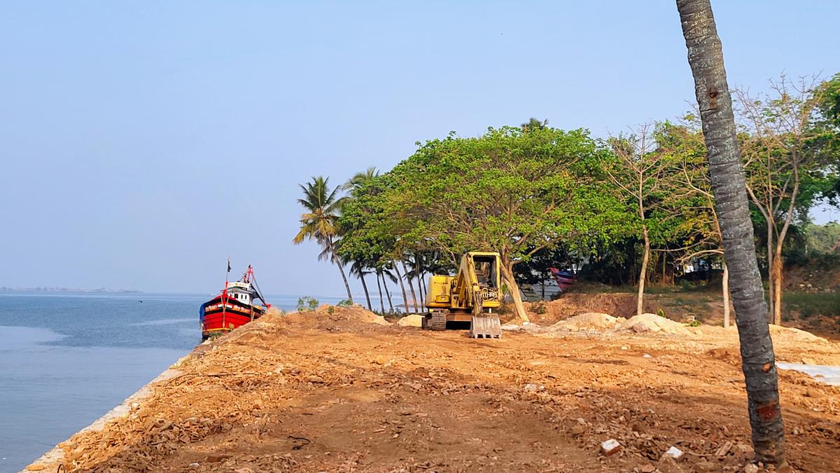
- 23 Mar 2024
Why is it in the News?
The principal bench of the National Green Tribunal (NGT) in New Delhi has initiated action on the Netravati Waterfront Promenade Development Project in Mangaluru.
About the Netravati River:
- The Netravati River, also known as Netravathi Nadi, originates from the Bangrabalige valley, Yelaneeru Ghat in Kudremukh, Chikkamagaluru district, Karnataka, India.
- It passes through the revered pilgrimage site Dharmasthala, earning recognition as one of India's sacred rivers.
- Converging with the Kumaradhara River at Uppinangadi, it eventually flows into the Arabian Sea, south of Mangalore city, serving as the primary water source for Bantwal and Mangalore.
- The Netravati railway bridge, a prominent structure, acts as the gateway to Mangalore.
- Historically known as the Bantwal River, it was documented as unfordable during the South-West Monsoon in the 1855 Gazetteer of Southern India.
- The river's navigability by small country craft and its influence on local geography and transport, including the naming of the Netravati Express train, underscores its significance in the region's history.
- Instances of flooding, notably in 1928 and 1974, have shaped the lives of residents, prompting relocations and resilience
About the National Green Tribunal:
- The National Green Tribunal (NGT) was established under the National Green Tribunal Act of 2010.
- While its principal seat is located in New Delhi, it also holds sessions in Bhopal, Pune, Kolkata, and Chennai.
- The NGT is entrusted with the responsibility of adjudicating applications or appeals, ensuring their final disposition within six months of filing.
Composition:
- The tribunal comprises a Chairperson, Judicial Members, and Expert Members, each serving a non-renewable term of five years.
- The appointment of the Chairperson is made by the Central Government in consultation with the Chief Justice of India (CJI).
- A Selection Committee, constituted by the Central Government, is responsible for appointing both Judicial and Expert Members.
- The tribunal can accommodate a minimum of 10 and a maximum of 20 full-time Judicial and Expert Members.
Powers & Jurisdiction:
- Established to efficiently handle cases concerning environmental protection and conservation of natural resources, including forests.
- It possesses appellate jurisdiction akin to a court.
- While not bound by the procedural formalities outlined in the Code of Civil Procedure, 1908, the NGT operates based on the principles of natural justice.
Earth’s early evolution: Fresh insights from rocks formed 3.5 billion years ago
- 23 Feb 2024
Why is it in the News?
Exploring ancient cratons such as the Singhbhum Craton in India, alongside similar formations in South Africa and Australia, provides unparalleled insights into the early stages of our planet's development, reaching back approximately 3.5 billion years.
What is Singhbhum Craton?
- The Singhbhum Craton encompasses a vast expanse of rugged terrain, primarily spanning regions in Jharkhand and Odisha, situated between the Chhota Nagpur plateau and the Eastern Ghats.
- Dating back approximately 3.5 billion years, this ancient segment of the Earth's crust offers valuable insights into early geological processes.
- Its oldest rock formations consist predominantly of volcanic and sedimentary rocks, referred to as greenstone successions.
- Greenstones are characterised by submarine volcanic rocks with minor sedimentary components.
- Geologically akin to greenstone belts in South Africa's Barberton and Nondweni regions and the Pilbara Craton in Western Australia, these areas experienced extensive submarine mafic volcanic activity, rich in magnesium oxide, between 3.5 and 3.3 billion years ago, with preserved features like pillowed lava and komatiites.
Significance:
- The Singhbhum Craton sheds light on early tectonic activities during the Archaean era, enhancing our understanding of the Earth's formative stages.
- Its distinctive geological characteristics, particularly the presence of greenstone belts, yield invaluable data on surface and atmospheric processes crucial for theorising about early habitable conditions and the emergence of life on Earth.
What are Cratons?
- A craton is a stable and ancient part of Earth's lithosphere that has experienced long-term tectonic and geomorphic stability.
- It is considered to be the nucleus of a continent and is characterised by its thick and cold lithosphere.
- Cratons can undergo destruction, which is defined as a geological process resulting in the loss of craton stability due to changes in its physical and chemical properties.
- The mechanisms responsible for craton destruction include oceanic plate subduction, rollback and retreat of subducting plates, stagnation and dehydration of subducting plates in the mantle transition zone, melting of the mantle caused by dehydration of stagnant slabs, non-steady flow in the upper mantle induced by melting, and changes like the lithospheric mantle.
- Craton destruction can lead to crustal thinning, surface uplift, and the concentration of mineral deposits.