Lab to monitor seawater quality and testbed to track monsoon systems inaugurated
- 14 Mar 2024
Why is it in the News?
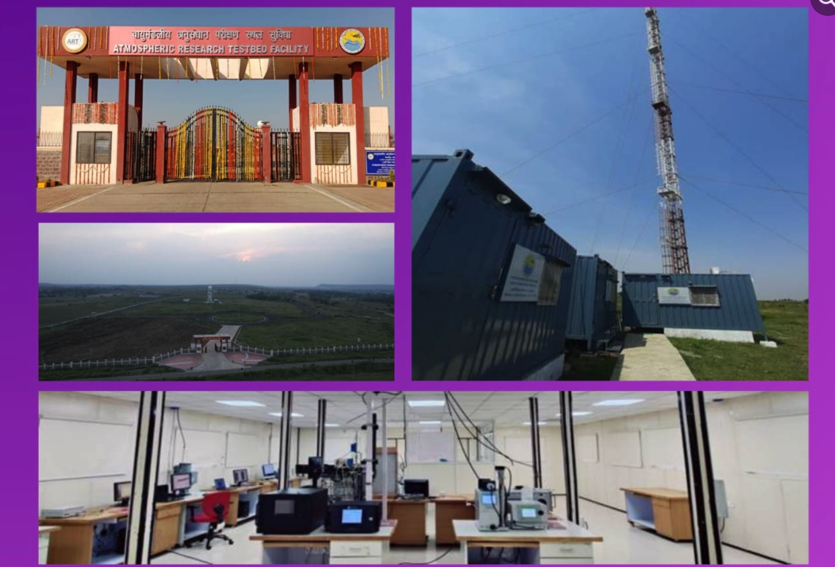
Recently India commissioned the atmospheric testbed facility near Bhopal, equipped with high-end instruments to record vital parameters for enhancing weather models and conducting advanced studies on the Indian monsoons, with construction commencing in early 2018.
What is the Atmospheric Research Testbed (ART)?
- The ART is an open-field, focused observational and analytical research programme at Silkheda.
- The facility aims to conduct ground-based observations of weather parameters like temperature, wind speeds, etc., and in-situ (on-site) observations of the transient synoptic systems – like low-pressure areas and depressions that form in the Bay of Bengal – during the southwest monsoon season from June to September.
- Studying these systems and their associated cloud parameters will be used to generate high volumes of data over a long period.
- It can then be compared with the existing weather models so that improvements can be made to obtain accurate rainfall predictions.
- The setup at ART will also be used for calibrating and validating various satellite-based observations, part of weather predictions and forecasting.
- Spread over 100 acres, the ART has been developed by the Ministry of Earth Sciences for Rs 125 crore.
- The Indian Institute of Tropical Meteorology (IITM), Pune, is in charge of the operations.
- Under the first phase, remote sensing-based and in-situ measurements using 25 meteorological instruments have commenced.
- In the second phase, ART will deploy instruments such as a radar wind profiler and balloon-bound radiosonde, and soil moisture and temperature measuring equipment.
What instruments are ART equipped with?
- To obtain continuous observations of convection, clouds, and precipitation, and monitor the major modes of variabilities, the ART is equipped with over two dozen high-end instruments, radars, and more.
- At 72 meters, ART will house India’s tallest meteorological tower.
- Some of the instruments deployed are an aethalometer for performing aerosol studies, a cloud condensation nuclei counter, a laser ceilometer to measure cloud sizes, a micro rain radar to calculate raindrop size and its distribution, and a Ka-band cloud radar and a C-band Doppler weather radar to help track the movement of rain-bearing systems over this zone.
Why is having an Atmospheric Research Testbed important?
- At present, 45% of India’s labor force is employed in the agriculture sector and much of Indian agriculture is rain-fed.
- Cultivation along the Monsoon Core Zone (MCZ), which spans the central India region from Gujarat to West Bengal, is primarily rainfall-fed.
- The southwest monsoon season accounts for 70 percent of the country’s annual average rainfall (880mm).
- Throughout India, the majority of Kharif cultivation is undertaken between July and August, which see an average monthly rainfall of 280.4mm and 254.9mm (1971–2020 average), respectively.
- During this four-month-long season, several rain-bearing synoptic systems, namely the low pressures or depressions, develop in the Bay of Bengal.
- Inherently, these systems move westwards/northwestwards over to the Indian mainland and pass through the MCZ, causing bountiful rainfall.
Why is it important to have data about monsoons over central India?
- Studies have correlated the all-India rainfall performance to the rainfall received over the central India region, highlighting its importance.
- The India Meteorological Department (IMD) issues rainfall forecasts for the country’s four homogeneous regions – north, west, east, and south peninsular India.
- In addition, it issues a special rainfall forecast for the MCZ, which is considered India’s food bowl.
- However, there is still limited understanding of the role of these synoptic systems, their associated cloud physics, cloud properties, and their overall role in enhancing the monsoon rainfall.
- Central India, therefore, acts as a natural laboratory for scientists and meteorologists to perform a hands-on study of the Indian monsoons.
- They can record data and make observations about the allied systems, clouds, and other associated physical and atmospheric parameters.
- Additionally, climate change is driving erratic rainfall patterns in tropical regions, like India.
- It has also strengthened the low-pressure systems, which are aided by high temperatures.
- This results in very heavy rainfall recorded along their trajectory during the monsoons.
- Now, with ART, scientists will be able to generate and obtain long-term observations on cloud microphysics, precipitation, convection, and land-surface properties, among a host of other parameters.
- This information will be assimilated and fed into the numerical weather models to enhance forecast output, especially the rainfall forecasts.
- More accurate forecasts will ultimately help the farming community plan their activities better.
Why Madhya Pradesh?
- The ART has been established at Silkheda, a location that falls directly in line with the path of major rain-bearing synoptic systems.
- This will facilitate direct monitoring and tracking.
- Besides, the locality is pristine and free of anthropogenic and other pollutants, making it the best site in central India for setting up sensitive, high-end meteorological instruments and observatories for recording data.
Exclusive-World on brink of fourth mass coral reef bleaching event- NOAA
- 06 Mar 2024
Why is it in the News?
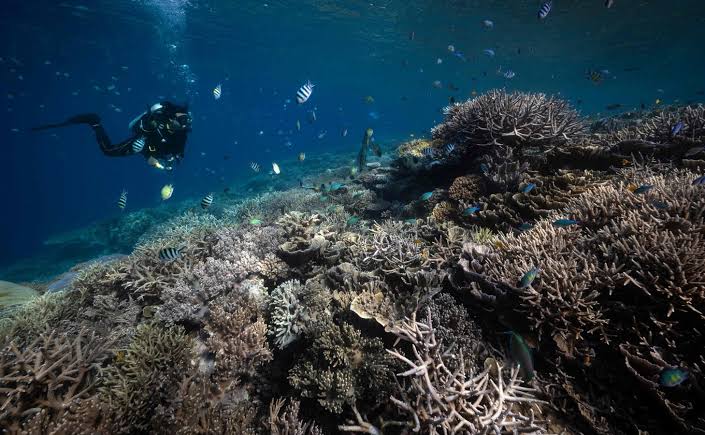
The world stands on the brink of witnessing its fourth mass coral bleaching event, a phenomenon that threatens to hit vast expanses of tropical reefs, including significant portions of Australia's iconic Great Barrier Reef.
Key Findings from the National Oceanic and Atmospheric Administration (NOAA):
- Impending Fourth Mass Coral Bleaching Event: The world is on the brink of a fourth mass coral bleaching event, following those in 1998, 2010, and 2014.
- To classify as global, widespread bleaching must occur across three ocean basins: the Atlantic, Pacific, and Indian.
- Impact of Previous Events: The last global mass coral bleaching event occurred from 2014 to 2017, resulting in the loss of nearly a third of the Great Barrier Reef's corals.
- Preliminary data indicates that approximately 15% of the world's reefs experienced significant coral die-offs during this event.
- Current Situation: This year is witnessing even more severe bleaching events, with the Caribbean experiencing its worst coral bleaching on record following the Northern Hemisphere summer last year.
- Link to Climate Phenomena: Coral bleaching is often associated with the naturally occurring El Niño climate phenomenon, which leads to warmer ocean waters.
- Climate Change Impact: The world recently experienced its first 12-month period with an average temperature exceeding 1.5 degrees Celsius (2.7 degrees Fahrenheit) above pre-industrial levels.
- A temperature rise of 1.5°C is considered the tipping point for mass coral die-offs, with scientists estimating that 90% of the world's corals could be lost as a result.
About the Corals and Coral Reefs:
- Corals: Corals are animals known as polyps, which engage in a symbiotic relationship with tiny algae called zooxanthellae.
- These algae provide corals with food and oxygen, while corals offer them a safe habitat.
- Coral Reefs: Coral reefs are limestone structures formed by thousands of tiny coral animals and are predominantly found in tropical climates.
Coral Bleaching and Its Concerns:
- Coral bleaching occurs when corals are exposed to stressful conditions like high temperatures, pollution, or changes in water chemistry, leading them to expel the zooxanthellae.
- Without these algae, corals lose their color and turn white, hence the term 'bleaching,' and cannot survive for long in this state.
- Recovery Potential: Despite its severity, coral bleaching doesn't necessarily mean the end of the reef; timely removal of stressors can facilitate the return of zooxanthellae and coral recovery.
- Ecological Importance: Coral reefs serve as habitats and food sources for numerous fish and marine species.
- They also offer coastal protection from erosion and storms and play a critical role in regulating the Earth's climate by absorbing and storing carbon dioxide.
- Cultural and Aesthetic Value: Beyond their ecological functions, coral reefs represent stunning biodiversity and natural beauty, making their loss a tragic prospect for future generations.
- Impacts: When coral reefs suffer, so do the ecosystems and communities reliant on them, underscoring the far-reaching consequences of coral degradation.
Prithvi Vigyan Scheme to Bolster Earth Science Research Approved by Cabinet (Indian Express)

- 08 Feb 2024
Why is it in the News?
The Union Cabinet has approved a Rs 4,797 crore research scheme to boost and maintain research momentum in the fields of ocean, atmospheric and polar sciences.
What is PRITHvi VIgyan (PRITHVI)?:
- The PRITHvi VIgyan (PRITHVI) will be an umbrella scheme spearheaded by the Ministry of Earth Sciences to help continue many of the ongoing research projects covering the period from 2021 to 2026.
- This scheme encompasses five existing sub-schemes:
- Atmosphere & Climate Research-Modelling Observing Systems & Services (ACROSS)
- Ocean Services, Modelling Application, Resources and Technology (O-SMART)
- Polar Science and Cryosphere Research (PACER)
- Seismology and Geosciences (SAGE)
- Research, Education, Training and Outreach (REACHOUT)
- The principal objectives of the comprehensive PRITHVI Scheme are as follows:
- Enhancing and maintaining long-term observations across the atmosphere, hydrosphere, geosphere, cryosphere, and biosphere to monitor critical indicators of the Earth System and its changes.
- Developing modelling systems to comprehend and forecast weather patterns, ocean dynamics, and climate-related hazards, while advancing the understanding of climate change science.
- Exploring the polar and high seas regions to uncover new phenomena and resources.
- Innovating technology for the exploration and sustainable utilization of oceanic resources benefits society at large.
- Translating insights from Earth systems science into services that contribute to societal well-being, environmental preservation, and economic prosperity.
- This scheme is poised to foster the development of integrated, multidisciplinary earth science research and innovative initiatives across various institutes under the MoES umbrella.
Significance of the PRITHVI Scheme:
- Under the PRITHVI Scheme, the Ministry of Earth Sciences (MoES) plays a pivotal role in delivering vital services concerning weather, climate, oceanography, coastal conditions, hydrology, seismology, and natural hazards.
- These services play a crucial role in issuing forecasts, warnings, and alerts for a wide array of natural disasters, including tropical cyclones, floods, tsunamis, and earthquakes.
- By facilitating disaster preparedness and risk mitigation, they contribute significantly to safeguarding lives and property.
- Earth System Sciences encompass a comprehensive study of the interconnected components of the Earth, including the atmosphere, hydrosphere, geosphere, cryosphere, and biosphere, along with their intricate interactions.
- The PRITHVI Scheme is designed to address these components comprehensively, enhancing our understanding of Earth System Sciences and delivering dependable services for the nation's benefit.
- Through integrated research and development endeavours across diverse MoES institutes, the scheme is poised to tackle major challenges in weather forecasting, climate science, oceanography, cryospheric studies, and seismology.
- These efforts aim to explore sustainable methods for harnessing both biological and non-biological resources, ensuring responsible utilization of our planet's resources.
“Pineapple Express” Sweeps California, Atmospheric River Leaves State In Distress (India Today)
- 05 Feb 2024
Why is it in the News?
A strong and grievous atmospheric river storm is predicted to hit California during the later part of Saturday, leaving over another storm, which resulted in extreme flooding in the last week.
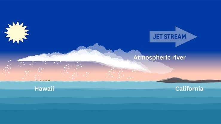
What is an Atmospheric River?
- Atmospheric rivers are long and relatively narrow bands of water vapor that form over an ocean and flow through the sky, transporting much of the moisture from the tropics to northern latitudes.
- They occur globally but are especially significant on the West Coast of the United States, where they create 30% to 50% of annual precipitation and are vital to water supplies but also can cause storms that produce flooding and mudslides.
- While they are an incredibly important source of rainfall, they can also bring flash flooding, mudslides, and landslides, sometimes killing people and destroying property.
- Formation: Formed by winds associated with cyclones, atmospheric rivers typically range from 250 miles to 375 miles (400 to 600 kilometers) in width and move under the influence of other weather.
- Many atmospheric river events are weak. But the powerful ones can transport extraordinary amounts of moisture.
- Studies have shown that they can carry seven to 15 times the average amount of water discharged daily by the Mississippi River.
- Forty-six atmospheric rivers made landfall in the U.S. West Coast during the water year 2023.
- Nine were categorized as strong, two were extreme and one was exceptional.
- California experienced extensive flooding and massive snowfall.
What Happens When an Atmospheric River Reaches Land?
- When the moisture-laden air moves over mountain ranges such as the Sierra Nevada along the California-Nevada line, the water vapor rises and cools, becoming heavy precipitation that falls as rain or snow.
- While traditional cold winter storms out of the north Pacific build the Sierra snowpack, atmospheric rivers tend to be warm.
- Snow may still fall at the highest elevations but rain usually falls on the snowpack at lower elevations.
- That can quickly prompt melting, runoff and flooding and decrease the snowpack needed for California’s water supply.
What is a Pineapple Express?
- It is a nickname for a strong atmospheric river in the tropical Pacific near Hawaii.
Where did the Term Atmospheric River Come From?
- The name came from research published in the 1990s by scientists Yong Zhu and Reginald E. Newell of the Massachusetts Institute of Technology.